Randall's Island
Park · Manhattan
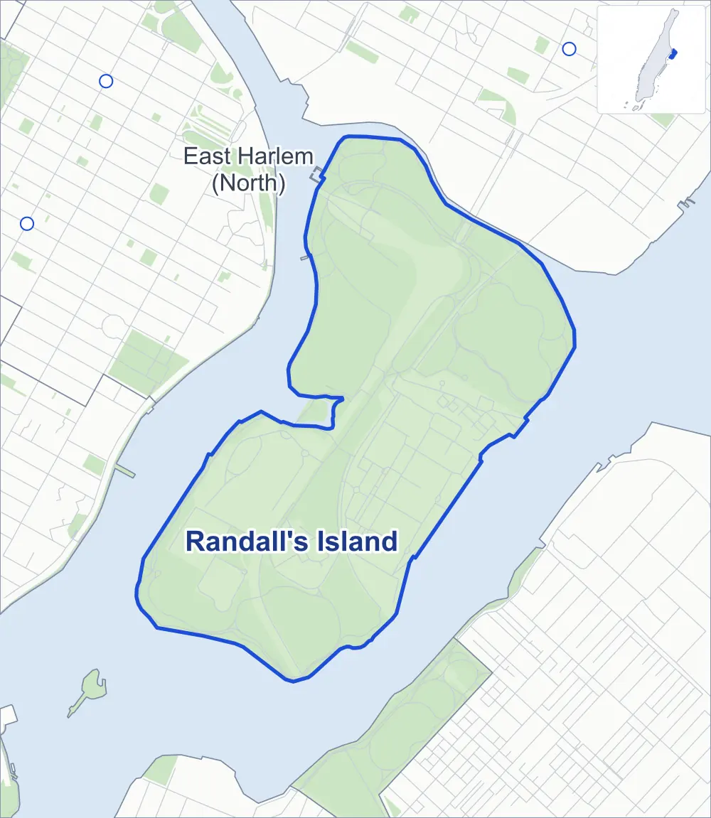
Randall's Island Park covers Randall's and Wards Islands, joined by landfill where the Harlem and East Rivers meet, between Manhattan, the Bronx and Queens.
- 0.84 square miles
- 90 street corners
- 1 bus route
Randall's Island is named for Jonathan Randel, who bought it in 1784, and Wards Island for the brothers Jaspar and Bartholomew Ward, who took it over after 1783; the state transferred the islands to the Parks Department in 1933, and the Triborough Bridge and a stadium opened there on July 11, 1936. Run in partnership with the nonprofit Randall's Island Park Alliance, the park is known for more than 60 baseball and softball fields, waterfront paths and a restored salt marsh.
Sources: History of the Island (Randall's Island Park Alliance); About Us (Randall's Island Park Alliance); Wards Island Park (NYC Parks).
Randall's Island borders one area, and Triborough Bridge holds more of its corners than any other street, 12 of 90.
- Randall's Island
- A neighboring area
- Park
- Another station
Neighborhood areas and streets: NYC Department of City Planning. Parks: NYC Parks. Stations: MTA.
Neighboring areas
- East Harlem (North) north
Getting around
One bus route stops in or at the edge of Randall's Island.
- 1 local bus route
Local bus route
- M35
Safety record
Between 2021 and 2025, its corners averaged fewer police-reported crashes than the average Manhattan corner.
- 1 police-reported crash at its corners
- 0.0 a corner, on average
- 13.4 the average Manhattan corner
- 89 corners with a clean record
Camera tickets
In 2025 the Department of Finance recorded no red-light, school-zone speed or bus-lane camera ticket at its corners.
Parks
- Parkland
- 310.3 acres of NYC Parks property
- The largest pieces
- Randall's Island Park (203.8 acres) and Wards Island Park (106.5 acres)
Streets and trees
- Trees
- 4,334 in NYC Parks' records, most often apple, mulberry and swamp white oak
- Street with the most corners
- Triborough Bridge, with 12 of the area's 90
- Height above sea level
- From 8 feet at 6th Drive & 8th Drive to 35 feet at Hell Gate Circle & Rivers Edge Road
Bike share and public art
By the station list of October 3, 2026, four bike-share stations stand in Randall's Island. The City's public art inventory lists one work in the area: Discus Thrower (1926).
- 4 bike-share stations
- 1 work of public art
Street corners
- 1st Drive & E Road
- 1st Drive & F Road
- 1st Drive & I Road
- 2nd Drive & B Road
- 2nd Drive & C Road
- 2nd Drive & E Road
- 2nd Drive & F Road
- 3rd Drive & B Road
- 3rd Drive & C Road
- 3rd Drive & D Road
- 3rd Drive & G Road
- 3rd Drive & H Road
- 3rd Drive & I Road
- 4th Drive & B Road
- 4th Drive & D Road
- 4th Drive & G Road
- 4th Drive & H Road
- 4th Drive & J Road
- 4th Drive & K Road
- 6th Drive & 8th Drive (north-east)
- 6th Drive & 8th Drive (south-west)
- 6th Drive & A Road
- 6th Drive & D Road
- 6th Drive & H Road
- 8th Drive & H Road
- A Road & 4th Drive
- Anaya Place & Kelly Street
- B Road & Laguardia Circle
- Berry Place & Rodriguez Place
- Bronx Shore Road & RFK Bridge Manhattan
- Bronx Shore Road & RFK Bridge Queens
- Cammarata Avenue & McCarron Drive
- Central Road & Hell Gate Circle
- Central Road & Reilly Boulevard
- Central Road & RFK Bridge Bronx (north)
- Central Road & RFK Bridge Bronx (south)
- Central Road & RFK Bridge Bronx Pedestrian and Bike Path
- Central Road & RFK Bridge Manhattan (north)
- Central Road & RFK Bridge Manhattan (south)
- Central Road & Sunken Meadow Loop
- D'Auria Street & Galanaugh Lane
- D'Auria Street & Kehayas Court
- Finley Place & Kelly Street
- Finley Place & Sears Street
- H Road & 7th Drive
- Hell Gate Circle & 2nd Drive
- Hell Gate Circle & C Road
- Hell Gate Circle & RFK Bridge Pedestrian and Bike Path
- Hell Gate Circle & RFK Bridge Queens
- Hell Gate Circle & RFK Bridge Queens Pedestrian and Bike Path
- Hell Gate Circle & Rivers Edge Road
- Hell Gate Circle & Sunken Garden Loop
- Hell Gate Circle & Wards Meadow Loop
- Higgins Avenue & Kelly Street
- Higgins Avenue & Sears Street
- J Road & 5th Drive
- J Road & 7th Drive
- K Road & 1st Drive
- Kaminsky Road & Allen Drive
- Kaminsky Road & Anaya Place
- Kaminsky Road & Brunn Street
- Kehayas Court & Rodriguez Place
- Kelly Street & Allen Drive
- McGinty Circle & Carl Lee Place
- Reilly Boulevard & Cammarata Avenue
- Reilly Boulevard & Carl Lee Place
- Reilly Boulevard & Kaminsky Road
- Reilly Boulevard & Kehayas Court
- Reilly Boulevard & Kelly Street
- Reilly Boulevard & Priore Road
- Reilly Boulevard & Sears Street
- RFK Bridge Pedestrian and Bike Path & RFK Bridge Queens Pedestrian and Bike Path
- Rivers Edge Road & Recovery Road
- Sunken Garden Loop & Charles Gay Loop (north-west)
- Sunken Garden Loop & Charles Gay Loop (south-east)
- Tepper Avenue & Berry Place
- Tepper Avenue & Priore Road
- Triborough Bridge & Bronx Shore Road
- Triborough Bridge & Central Road
- Triborough Bridge & RFK Bridge
- Triborough Bridge & RFK Bridge Bronx
- Triborough Bridge & RFK Bridge Manhattan
- Triborough Bridge & RFK Bridge Manhattan Randalls Island Ramp
- Triborough Bridge & RFK Bridge Queens (Ramp Randalls Island)
- Triborough Bridge & RFK Bridge Queens (Ramp)
- Triborough Bridge & Rivers Edge Road
- Triborough Bridge & Sunken Garden Loop
- Triborough Bridge & Wards Meadow Loop (north-west)
- Triborough Bridge & Wards Meadow Loop (south-east)
- Wards Meadow Loop & East River Lane
How the figures above are measured: Methodology.