The Bronx
The Bronx is the northernmost borough and, apart from a sliver of Manhattan, the only part of the city on the mainland.
- 6,052 street corners
- 37 residential neighborhoods
- 42.7 square miles of land
- 1,406,332 residents Census Bureau estimate, July 1, 2025
It is named for Jonas Bronck, a sea captain born in Sweden who settled there in 1639, and it became a county of its own, Bronx County, in 1914.
Neighborhoods
Open the map full sizeThe Bronx's corners lie in 48 neighborhood areas, and Throgs Neck-Schuylerville holds the most, 522.
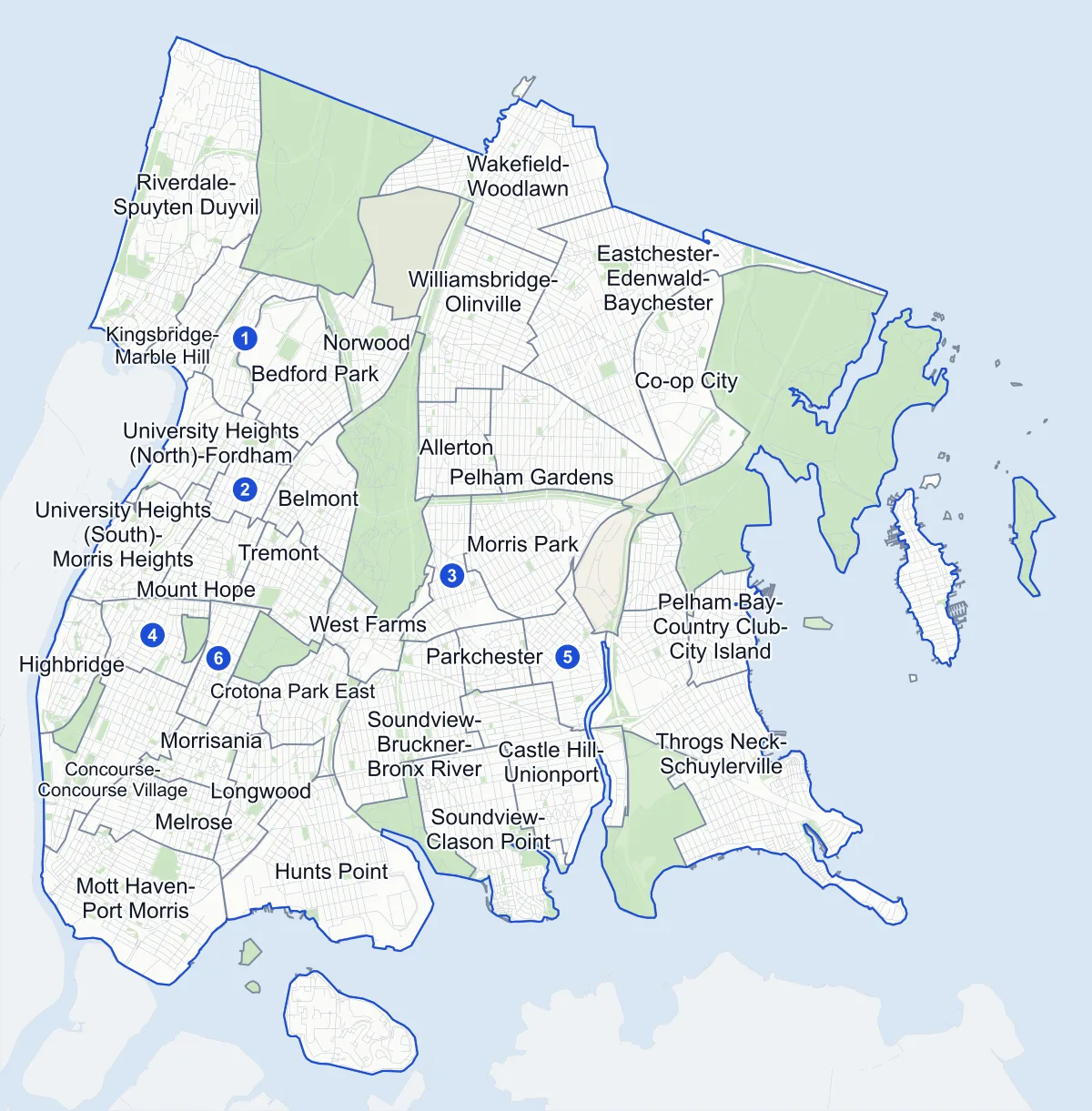
- Neighborhood
- Park
- Cemetery
- Other area
- Another borough
- Name in the list
Neighborhood areas and streets: NYC Department of City Planning. Parks: NYC Parks.
Residential neighborhoods
- Allerton 111 corners
- Bedford Park 105 corners
- Belmont 115 corners
- Castle Hill-Unionport 165 corners
- Claremont Village-Claremont (East) 66 corners
- Co-op City 80 corners
- Concourse-Concourse Village 183 corners
- Crotona Park East 118 corners
- Eastchester-Edenwald-Baychester 320 corners
- Fordham Heights 62 corners
- Highbridge 118 corners
- Hunts Point 194 corners
- Kingsbridge Heights-Van Cortlandt Village 85 corners
- Kingsbridge-Marble Hill 64 corners
- Longwood 108 corners
- Melrose 137 corners
- Morris Park 179 corners
- Morrisania 108 corners
- Mott Haven-Port Morris 266 corners
- Mount Eden-Claremont (West) 116 corners
- Mount Hope 103 corners
- Norwood 107 corners
- Parkchester 47 corners
- Pelham Bay-Country Club-City Island 251 corners
- Pelham Gardens 204 corners
- Pelham Parkway-Van Nest 120 corners
- Riverdale-Spuyten Duyvil 315 corners
- Soundview-Bruckner-Bronx River 196 corners
- Soundview-Clason Point 209 corners
- Throgs Neck-Schuylerville 522 corners
- Tremont 138 corners
- University Heights (North)-Fordham 97 corners
- University Heights (South)-Morris Heights 147 corners
- Wakefield-Woodlawn 264 corners
- West Farms 98 corners
- Westchester Square 137 corners
- Williamsbridge-Olinville 217 corners
Parks, cemeteries and other areas
11 areas
- Bronx Park 49 corners
- Crotona Park one corner
- Ferry Point Park-St. Raymond Cemetery three corners
- Hart Island eight corners
- Hutchinson Metro Center 34 corners
- Pelham Bay Park 51 corners
- Rikers Island 15 corners
- Soundview Park four corners
- Van Cortlandt Park 13 corners
- Woodlawn Cemetery one corner
- Yankee Stadium-Macombs Dam Park one corner
Parks and trees
Pelham Bay Park is the largest park in New York City.
- 340 parks
- 138,047 trees in NYC Parks' records
Van Cortlandt Park and Bronx Park are the next largest of the borough's parks.
Getting around
- 68 subway station complexes
- 7 subway lines
- 61 bus routes with stops in the Bronx
The lines that stop inside the Bronx are the 1, 2, 4, 5, 6, B and D.
Safety record
Half of the Bronx's corners had four or fewer police-reported crashes between 2021 and 2025, and almost one in five had none.
- 48,495 police-reported crashes in all
- 1,247 corners with a signal or safety change, in the Department of Transportation's records
Public safety
How complaints are countedThe NYPD recorded 30,327 major felonies in 2025 across the Bronx's precincts, leaving out those in the Department of Correction's jurisdiction.
The 50th Precinct's count includes Marble Hill, which is part of Manhattan.
Camera tickets
Bruckner Boulevard & White Plains Road had 53,903 school-zone speed camera tickets in 2025, more than any corner in the city but one.
- 69,186 red-light camera tickets at 20 corners on the list
- 600,619 school-zone speed camera tickets at 318 corners on the list
- 100,817 bus-lane camera tickets at 31 corners on the list
The Bronx's corners on the city-wide camera-ticket lists: Red-light camera tickets · School-zone speed camera tickets · Bus-lane camera tickets
Elevation
The Bronx's highest corner stands above every corner outside Staten Island.
- Highest
- Grosvenor Avenue & Goodridge Avenue, in Riverdale-Spuyten Duyvil, 276 feet above sea level
- Lowest
- 1st Avenue & Sound View Street, in Throgs Neck-Schuylerville, 4 feet above sea level
Streets
There are 1,311 streets in the Bronx with two or more intersections, each listing its corners in order along the road.
Questions about the Bronx
How many neighborhoods are in the Bronx? The Bronx has 37 residential neighborhood areas on City Planning's 2020 map, and 50 areas in all, counting parks, cemeteries, an island and one other non-residential area.
What is the biggest park in the Bronx? Pelham Bay Park, which is also the largest in the city.
What is the population of the Bronx? By the Census Bureau's latest estimate, 1,406,332 people lived in the Bronx on July 1, 2025; the 2020 Census counted 1,472,654.
Sources: New York City: The boroughs (Encyclopaedia Britannica); Bronx Park Highlights (NYC Parks).