Bedford Park
Neighborhood · Bronx
Bedford Park sits in the northwest Bronx beside the Jerome Park Reservoir, with Mosholu Parkway to the north and Webster Avenue to the east.
- 0.88 square miles
- 55,521 residents, 2020 Census
- 105 street corners
- 4 subway stations
- 17 bus routes
Developers built a planned suburb of 40 villas here in the late 19th century, and the Jerome Park Racetrack, opened in 1866, gave way to the reservoir, completed in 1906. The Grand Concourse was finished in 1914 and the Jerome Avenue subway arrived in 1917, and the area became known for its schools, among them the Bronx High School of Science and Lehman College, whose campus, then Hunter College's Bronx branch, briefly hosted the United Nations in 1946.
Sources: Bedford Park, Bronx (Wikipedia); Bedford Park (Bronx Community Board 7).
Bedford Park borders four areas, and Jerome Avenue holds more of its corners than any other street, 16 of 105.
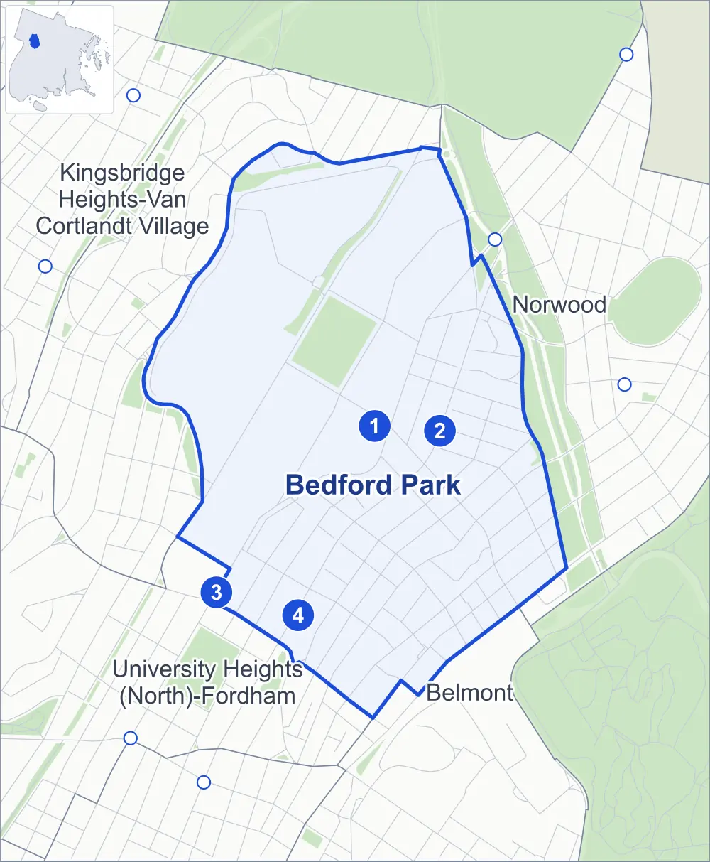
- Bedford Park
- A neighboring area
- Park
- A station in the list
- Another station
Neighborhood areas and streets: NYC Department of City Planning. Parks: NYC Parks. Stations: MTA.
Neighboring areas
- Norwood east
- Belmont south
- University Heights (North)-Fordham southwest
- Kingsbridge Heights-Van Cortlandt Village northwest
Subway stations
- Bedford Park Blvd-Lehman College lines 4
- Bedford Park Blvd lines B D accessible
- Kingsbridge Rd lines 4
- Kingsbridge Rd lines B D accessible
Getting around
Four subway stations and buses on 17 routes stop in or at the edge of Bedford Park.
- 4 subway stations
- 2 of them listed by the MTA as fully accessible
- 15 local bus routes
- 2 express bus routes
Local bus routes
- Bx1
- Bx2
- Bx3
- Bx9
- Bx10
- Bx22
- Bx25
- Bx26
- Bx28
- Bx32
- Bx34
- Bx38
- Bx41
- Bx41-SBS
- BX95
Express bus routes
- BxM3
- BxM4
Safety record
Between 2021 and 2025, its corners averaged more police-reported crashes than the average Bronx corner.
- 1,115 police-reported crashes at its corners
- 10.6 a corner, on average
- 8.0 the average Bronx corner
- 1 corner with a clean record
Signal or safety changes on City record, at 23 of its corners
- Leading pedestrian intervals
- 20
- Accessible pedestrian signals
- 16
- Turn calming
- 2
- Safety Improvement Projects
- 1
Camera tickets
In 2025 its corners had more school-zone speed camera tickets than red-light or bus-lane tickets.
- 0 red-light camera tickets
- 18,001 school-zone speed camera tickets at six corners
- 0 bus-lane camera tickets
- Most speed tickets
- Sedgwick Avenue & Saxon Avenue, 11,705
People and homes
The 2020 Census counted 55,521 residents in Bedford Park, about 63,100 per square mile.
- 21,029 homes, 2020 Census
- 4,091 homes added since April 2010, net, by City Planning's count
Half of its 1,119 residential lots hold buildings from 1920 or earlier, and 83% of them date from before 1940, by the City's tax lot records.
Parks and landmarks
- Parkland
- 22.9 acres of NYC Parks property
- The largest pieces
- Harris Park (14.6 acres), Jerome Park (4.2 acres) and Fort Independence Playground (2.7 acres)
- Designated landmarks
- The Bedford Park Congregational Church and the High Pumping Station
- Historic district
- Perry Avenue Historic District, wholly or partly within Bedford Park
Streets and trees
- Trees
- 2,876 in NYC Parks' records, most often thornless honeylocust, pin oak and London planetree
- Street with the most corners
- Jerome Avenue, with 16 of the area's 105
- Height above sea level
- From 58 feet at Webster Avenue & East 195th Street to 160 feet at East 206th Street & St Georges Crescent
- Honorary street names
- 9 at its corners, enacted by local law
Schools
The City lists 23 schools in Bedford Park.
- Public schools
- 16
- Charter and private schools
- 7
Bike share
By the station list of October 3, 2026, 25 bike-share stations stand in Bedford Park.
- 25 bike-share stations
Public safety
How complaints are countedIn 2025 the NYPD recorded 786 major felonies at places in Bedford Park.
Recorded by the NYPD at places in Bedford Park
- 675 major felonies in 2024
- 2,251 other felonies, misdemeanors and violations in 2025
In 2025, on the streets along the edge of Bedford Park, the NYPD recorded another 273 major felonies. Counting the streets along its edge, in 2025 the NYPD recorded 19.1 major felonies for every thousand residents the 2020 Census counted in Bedford Park.
- Police precincts
- 52nd (most of the area), 50th
From January to June 2026 the NYPD recorded 374 major felonies at places in Bedford Park, against 359 in the same months of 2025.
Sources: the NYPD's Complaint Data Historic, updated April 28, 2026, and Complaint Data Current (Year To Date), updated July 27, 2026, on NYC Open Data. Figures to June 30, 2026.
Street corners
- Bainbridge Avenue & Bedford Park Boulevard
- Bainbridge Avenue & East 196th Street
- Bainbridge Avenue & East 197th Street (north-east)
- Bainbridge Avenue & East 197th Street (south-west)
- Bainbridge Avenue & East 198th Street
- Bainbridge Avenue & East 199th Street
- Bainbridge Avenue & East 201st Street
- Bedford Park Boulevard & Villa Avenue
- Bedford Park Boulevard West & Paul Avenue
- Briggs Avenue & Bedford Park Boulevard
- Briggs Avenue & East 196th Street
- Briggs Avenue & East 197th Street
- Briggs Avenue & East 198th Street
- Briggs Avenue & East 199th Street
- Briggs Avenue & East 201st Street
- Briggs Avenue & East 202nd Street
- Briggs Avenue & East Mosholu Parkway South
- Creston Avenue & East 196th Street
- Creston Avenue & East 197th Street
- Creston Avenue & East 198th Street
- Creston Avenue & Minerva Place
- Decatur Avenue & Bedford Park Boulevard
- Decatur Avenue & East 197th Street
- Decatur Avenue & East 198th Street
- Decatur Avenue & East 199th Street
- Decatur Avenue & East 201st Street
- Decatur Avenue & East Mosholu Parkway South
- Decatur Avenue & Oliver Place
- East 196th Street & Parkview Terrace
- East 197th Street & Pond Place
- East 198th Street & Pond Place
- East 204th Street & Villa Avenue
- East 205th Street & Lisbon Place
- East 205th Street & Villa Avenue
- East 206th Street & St Georges Crescent
- East Mosholu Parkway South & East 204th Street
- East Mosholu Parkway South & Lisbon Place
- Goulden Avenue & Bedford Park Boulevard West
- Goulden Avenue & Jerome Park Reservoir Path
- Goulden Avenue & West 197th Street
- Goulden Avenue & West 205th Street
- Grand Concourse & Bedford Park Boulevard
- Grand Concourse & East 196th Street
- Grand Concourse & East 198th Street
- Grand Concourse & East 204th Street
- Grand Concourse & East Kingsbridge Road
- Grand Concourse & Van Cortlandt Avenue East
- Jerome Avenue & Bedford Park Boulevard West
- Jerome Avenue & East 196th Street
- Jerome Avenue & East 198th Street
- Jerome Avenue & East 199th Street
- Jerome Avenue & East 204th Street
- Jerome Avenue & East 205th Street
- Jerome Avenue & Kingsbridge Road
- Jerome Avenue & Minerva Place
- Jerome Avenue & Morris Avenue
- Jerome Avenue & Mosholu Parkway South
- Jerome Avenue & Parkview Terrace
- Jerome Avenue & Paul Avenue
- Jerome Avenue & Van Cortlandt Avenue East
- Jerome Avenue & West 195th Street
- Jerome Avenue & West 205th Street
- Jerome Avenue & West Mosholu Parkway South
- Marion Avenue & Bedford Park Boulevard
- Marion Avenue & East 195th Street
- Marion Avenue & East 196th Street
- Marion Avenue & East 197th Street
- Marion Avenue & East 198th Street
- Marion Avenue & East 199th Street
- Marion Avenue & East 201st Street
- Marion Avenue & East Mosholu Parkway South
- Marion Avenue & Oliver Place
- Morris Avenue & East 196th Street
- Morris Avenue & Parkview Terrace
- Paul Avenue & West 205th Street
- Perry Avenue & Bedford Park Boulevard
- Perry Avenue & East 201st Street
- Perry Avenue & East Mosholu Parkway South
- Reservoir Avenue & Claflin Avenue
- Reservoir Avenue & West 195th Street
- Sedgwick Avenue & Fort Independence Street
- Sedgwick Avenue & Giles Place
- Sedgwick Avenue & Hillman Avenue
- Sedgwick Avenue & Saxon Avenue
- Valentine Avenue & Bedford Park Boulevard
- Valentine Avenue & East 196th Street
- Valentine Avenue & East 197th Street
- Valentine Avenue & East 198th Street
- Valentine Avenue & East 199th Street
- Valentine Avenue & East 201st Street
- Valentine Avenue & East 202nd Street
- Valentine Avenue & East 203rd Street
- Valentine Avenue & East 204th Street
- Valentine Avenue & East Kingsbridge Road at East 194th Street
- Valentine Avenue & Miriam Street
- Van Cortlandt Avenue East & Risse Street
- Van Cortlandt Avenue East & St Georges Crescent
- Van Cortlandt Avenue East & Villa Avenue
- Webster Avenue & Botanical Square South
- Webster Avenue & East 195th Street
- Webster Avenue & East 197th Street
- Webster Avenue & East 198th Street
- Webster Avenue & East 199th Street
- Webster Avenue & East Mosholu Parkway South
- Webster Avenue & Oliver Place
How the figures above are measured: Methodology.