Queens
Queens is the largest of the five boroughs, and it has more street corners than any other.
- 16,388 street corners
- 59 residential neighborhoods
- 109.1 square miles of land
- 2,358,182 residents Census Bureau estimate, July 1, 2025
Its county was established in 1683 and named for Catherine of Braganza, queen consort of Charles II, and it became part of Greater New York in 1898.
Neighborhoods
Open the map full sizeSt. Albans has more corners than any other neighborhood area in Queens: 579.
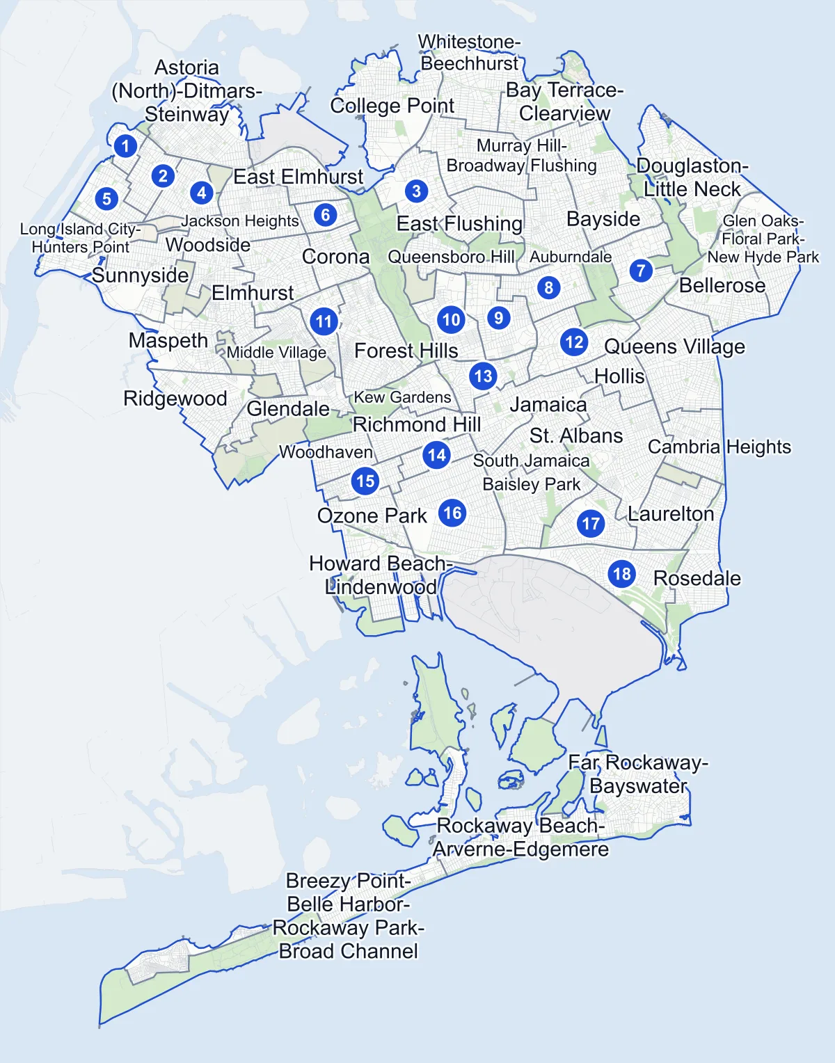
- Neighborhood
- Park
- Cemetery
- Airport
- Other area
- Another borough
- Name in the list
Neighborhood areas and streets: NYC Department of City Planning. Parks: NYC Parks.
Residential neighborhoods
- Astoria (Central) 124 corners
- Astoria (East)-Woodside (North) 152 corners
- Astoria (North)-Ditmars-Steinway 330 corners
- Auburndale 436 corners
- Baisley Park 331 corners
- Bay Terrace-Clearview 177 corners
- Bayside 464 corners
- Bellerose 284 corners
- Breezy Point-Belle Harbor-Rockaway Park-Broad Channel 429 corners
- Cambria Heights 230 corners
- College Point 318 corners
- Corona 220 corners
- Douglaston-Little Neck 428 corners
- East Elmhurst 177 corners
- East Flushing 208 corners
- Elmhurst 335 corners
- Far Rockaway-Bayswater 407 corners
- Flushing-Willets Point 227 corners
- Forest Hills 439 corners
- Fresh Meadows-Utopia 179 corners
- Glen Oaks-Floral Park-New Hyde Park 219 corners
- Glendale 232 corners
- Hollis 186 corners
- Howard Beach-Lindenwood 317 corners
- Jackson Heights 253 corners
- Jamaica 350 corners
- Jamaica Estates-Holliswood 227 corners
- Jamaica Hills-Briarwood 205 corners
- Kew Gardens 135 corners
- Kew Gardens Hills 171 corners
- Laurelton 299 corners
- Long Island City-Hunters Point 212 corners
- Maspeth 414 corners
- Middle Village 295 corners
- Murray Hill-Broadway Flushing 396 corners
- North Corona 98 corners
- Oakland Gardens-Hollis Hills 208 corners
- Old Astoria-Hallets Point 66 corners
- Ozone Park 215 corners
- Ozone Park (North) 141 corners
- Pomonok-Electchester-Hillcrest 201 corners
- Queens Village 537 corners
- Queensboro Hill 190 corners
- Queensbridge-Ravenswood-Dutch Kills 159 corners
- Rego Park 121 corners
- Richmond Hill 203 corners
- Ridgewood 288 corners
- Rockaway Beach-Arverne-Edgemere 292 corners
- Rosedale 314 corners
- South Jamaica 308 corners
- South Ozone Park 488 corners
- South Richmond Hill 94 corners
- Springfield Gardens (North)-Rochdale Village 220 corners
- Springfield Gardens (South)-Brookville 336 corners
- St. Albans 579 corners
- Sunnyside 276 corners
- Whitestone-Beechhurst 335 corners
- Woodhaven 185 corners
- Woodside 284 corners
Parks, cemeteries, airports and other areas
14 areas
- Alley Pond Park 15 corners
- Astoria Park one corner
- Calvary & Mount Zion Cemeteries one corner
- Cunningham Park ten corners
- Flushing Meadows-Corona Park 153 corners
- Forest Park ten corners
- Fort Totten 40 corners
- Highland Park-Cypress Hills Cemeteries (North) nine corners
- Jacob Riis Park-Fort Tilden-Breezy Point Tip 23 corners
- John F. Kennedy International Airport 101 corners
- LaGuardia Airport 29 corners
- Mount Hebron & Cedar Grove Cemeteries one corner
- Sunnyside Yards (North) 18 corners
- Sunnyside Yards (South) 18 corners
Areas drawn in Brooklyn
six areas
City Planning draws these areas in Brooklyn, but some of their street corners are in Queens.
- Bushwick (East) four corners
- Bushwick (West) three corners
- Cypress Hills three corners
- East New York-City Line two corners
- East Williamsburg one corner
- Highland Park-Cypress Hills Cemeteries (South) two corners
Getting around
- 79 subway station complexes
- 13 subway lines
- 135 bus routes with stops in Queens
Safety record
More than one Queens corner in five had a clean record, with no police-reported crash between 2021 and 2025.
- 3,690 corners with a clean record
- 85,687 police-reported crashes in all
- 3 crash count at the median corner
- 1,901 corners with a signal or safety change
The change made most often is a leading pedestrian interval, which lets people on foot start crossing before cars move: 1,356 Queens corners have one.
Public safety
How complaints are countedFor 2025, the NYPD recorded 26,418 major felonies across Queens's precincts, other than those in the Department of Correction's jurisdiction.
Roosevelt Island, in Manhattan, is counted in the 114th Precinct.
Camera tickets
In 2025 Queens had more school-zone speed camera and bus-lane camera tickets than any other borough, and the second most red-light tickets.
- 180,082 red-light camera tickets at 66 corners on the list Second to Brooklyn
- 1,316,399 school-zone speed camera tickets at 605 corners on the list Most of any borough
- 351,811 bus-lane camera tickets at 31 corners on the list Most of any borough
The busiest corners
- North Conduit Avenue & 88th Street
- 101,974 school-zone speed camera tickets, the most of any corner in New York
- Jamaica Avenue & 149th Street
- 91,989 bus-lane camera tickets, also the city's most
Queens's corners on the city-wide camera-ticket lists: Red-light camera tickets · School-zone speed camera tickets · Bus-lane camera tickets
Parks and trees
Queens has more trees in NYC Parks' records than any other borough.
- 298,346 trees in NYC Parks' records
- 407 parks
Of the parks in Queens, Flushing Meadows Corona Park is the largest, with Alley Pond Park and Forest Park next in size.
Elevation
In Queens, street corners range from 2 feet to 246 feet above sea level.
- Highest
- Grand Central Parkway & 267th Street, in Glen Oaks-Floral Park-New Hyde Park
- Lowest
- 1st Street & Meyer Avenue, in Rosedale
Streets
There are 2,276 streets in Queens with two or more intersections, each listing its corners in order along the road.
Questions about Queens
How many neighborhoods are in Queens? Of the 82 areas City Planning draws in Queens, 59 are residential neighborhoods; the rest are parks, cemeteries, two airports and other non-residential areas.
What is the population of Queens? About 2.36 million. The Census Bureau's July 1, 2025 estimate is 2,358,182, down from 2,405,464 in the 2020 Census.
What is the largest park in Queens? Flushing Meadows Corona Park, the biggest of the 407 parks in the borough.
Sources: Queens (Encyclopaedia Britannica); Traffic Signals (NYC Department of Transportation).