Elmhurst
Neighborhood · Queens
Elmhurst lies between Roosevelt Avenue and the Long Island Expressway, west of Junction Boulevard, on the site of the colonial village that served as seat of the town of Newtown.
- 1.51 square miles
- 107,864 residents, 2020 Census
- 335 street corners
- 7 subway stations
- 22 bus routes
Settlers founded it as Middleburgh in 1652, it was renamed Newtown after the English took over the colony in 1664, and in 1896 Cord Meyer gave it the name Elmhurst, a nod to its many elm trees. Landmarks include St. James Church, built in 1735-36 and the city's oldest and only surviving vernacular mission church of the Church of England, and Newtown High School, built in 1920-21 and designated a city landmark in 2003.
Sources: National Register of Historic Places Registration Form: St. James Church (National Park Service); Newtown High School (LP-2131), designation report, June 24, 2003 (NYC Landmarks Preservation Commission); Elmhurst, Queens (Wikipedia).
Elmhurst borders six areas, and 94th Street holds more of its corners than any other street, 29 of 335.
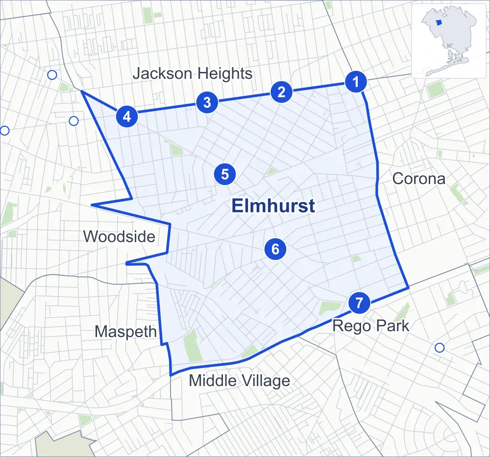
- Elmhurst
- A neighboring area
- Park
- A station in the list
- Another station
Neighborhood areas and streets: NYC Department of City Planning. Parks: NYC Parks. Stations: MTA.
Neighboring areas
- Jackson Heights north
- Corona east
- Rego Park southeast
- Middle Village south
- Maspeth southwest
- Woodside west
Subway stations
- Junction Blvd lines 7 accessible
- 90 St-Elmhurst Av lines 7
- 82 St-Jackson Hts lines 7
- 74 St-Broadway / Jackson Hts-Roosevelt Av lines 7 E F M R accessible
- Elmhurst Av lines M R
- Grand Av-Newtown lines M R
- Woodhaven Blvd lines M R
Getting around
Seven subway stations and buses on 22 routes stop in or at the edge of Elmhurst.
- 7 subway stations
- 2 of them listed by the MTA as fully accessible
- 17 local bus routes
- 5 express bus routes
Local bus routes
- Q11
- Q14
- Q29
- Q32
- Q33
- Q47
- Q49
- Q52-SBS
- Q53-SBS
- Q58
- Q59
- Q60
- Q70-SBS
- Q72
- Q88
- Q98
- T320
Express bus routes
- QM10
- QM11
- QM12
- QM40
- QM42
Safety record
Between 2021 and 2025, its corners averaged more police-reported crashes than the average Queens corner.
- 2,793 police-reported crashes at its corners
- 8.3 a corner, on average
- 5.2 the average Queens corner
- 28 corners with a clean record
Signal or safety changes on City record, at 80 of its corners
- Leading pedestrian intervals
- 59
- Turn calming
- 33
- Accessible pedestrian signals
- 27
- Safety Improvement Projects
- 6
- Barnes Dance all-way crossings
- 4
- Enhanced crossings
- 2
Camera tickets
In 2025 its corners had more school-zone speed camera tickets than red-light or bus-lane tickets.
- 5,241 red-light camera tickets at two corners
- 9,143 school-zone speed camera tickets at ten corners
- 3,346 bus-lane camera tickets at two corners
- Most red-light tickets
- Queens Boulevard & Broadway, 5,233
- Most speed tickets
- Queens Boulevard & 51st Avenue, 3,979
- Most bus-lane tickets
- Queens Boulevard & Broadway, 2,821
People and homes
The 2020 Census counted 107,864 residents in Elmhurst, about 71,400 per square mile.
- 35,849 homes, 2020 Census
- 2,632 homes added since April 2010, net, by City Planning's count
Half of its 6,730 residential lots hold buildings from 1940 or earlier, and 47% of them date from before 1940, by the City's tax lot records.
Parks and landmarks
- Parkland
- 16.5 acres of NYC Parks property
- The largest pieces
- Elmhurst Park (6.1 acres), Hoffman Park (2.9 acres) and Moore Homestead Playground (2 acres)
- Designated landmarks
- The Newtown High School; the Benevolent and Protective Order of Elks, Lodge Number 878; the Reformed Dutch Church of Newtown; and the Reformed Dutch Church of Newtown (Fellowship Hall), among others
Streets and trees
- Trees
- 5,109 in NYC Parks' records, most often thornless honeylocust, pin oak and London planetree
- Street with the most corners
- 94th Street, with 29 of the area's 335
- Height above sea level
- From 15 feet at Horace Harding Expressway & Junction Boulevard to 101 feet at 74th Street & Grand Avenue
- Honorary street names
- 15 at its corners, enacted by local law
Schools and libraries
The City lists 21 schools and one library in Elmhurst.
- Public schools
- 11
- Charter and private schools
- 10
- Library
- Elmhurst Library
Bike share
By the station list of October 3, 2026, 35 bike-share stations stand in Elmhurst.
- 35 bike-share stations
Public safety
How complaints are countedIn 2025 the NYPD recorded 1,175 major felonies at places in Elmhurst.
Recorded by the NYPD at places in Elmhurst
- 1,473 major felonies in 2024
- 3,791 other felonies, misdemeanors and violations in 2025
In 2025, on the streets along the edge of Elmhurst, the NYPD recorded another 346 major felonies.
- Police precincts
- 110th (most of the area), 104th, 115th, 108th
From January to June 2026 the NYPD recorded 545 major felonies at places in Elmhurst, against 562 in the same months of 2025.
Sources: the NYPD's Complaint Data Historic, updated April 28, 2026, and Complaint Data Current (Year To Date), updated July 27, 2026, on NYC Open Data. Figures to June 30, 2026.
Street corners
- 40th Road & Warren Street
- 41st Avenue & 72nd Street
- 41st Avenue & 73rd Street
- 41st Avenue & 74th Street
- 41st Avenue & 75th Street
- 41st Avenue & 76th Street
- 41st Avenue & 77th Street
- 41st Avenue & 78th Street
- 41st Avenue & 81st Street
- 41st Avenue & 94th Street
- 41st Avenue & 95th Street
- 41st Avenue & Broadway
- 41st Avenue & Judge Street
- 41st Avenue & Junction Boulevard
- 41st Avenue & Warren Street
- 42nd Avenue & Junction Boulevard
- 42nd Avenue & Warren Street
- 43rd Avenue & 74th Street
- 43rd Avenue & 76th Street
- 43rd Avenue & 88th Street
- 43rd Avenue & 91st Place
- 43rd Avenue & 94th Street
- 43rd Avenue & 94th Street at Elbertson Street
- 43rd Avenue & 95th Street
- 43rd Avenue & Forley Street
- 43rd Avenue & Gleane Street
- 43rd Avenue & Hampton Street
- 43rd Avenue & Ithaca Street
- 43rd Avenue & Judge Street
- 43rd Avenue & Junction Boulevard
- 43rd Avenue & Whitney Avenue
- 44th Avenue & Junction Boulevard
- 45th Avenue & 70th Street
- 45th Avenue & 72nd Street
- 45th Avenue & 74th Street
- 45th Avenue & 76th Street
- 45th Avenue & 77th Street
- 45th Avenue & 81st Street
- 45th Avenue & 82nd Street
- 45th Avenue & 83rd Street
- 45th Avenue & 94th Street
- 45th Avenue & Broadway
- 46th Avenue & 74th Street
- 46th Avenue & 94th Street
- 46th Avenue & Junction Boulevard
- 47th Avenue & 76th Street
- 47th Avenue & 82nd Street
- 48th Avenue & 90th Street
- 48th Avenue & 91st Place
- 48th Avenue & 91st Street
- 48th Avenue & 92nd Street
- 48th Avenue & 93rd Street
- 48th Avenue & Corona Avenue
- 50th Avenue & 90th Street
- 50th Avenue & 91st Place
- 50th Avenue & 91st Street
- 50th Avenue & 92nd Street
- 50th Avenue & 93rd Street
- 50th Avenue & 94th Street
- 50th Avenue & O'Connell Court
- 51st Avenue & 73rd Place
- 51st Avenue & 87th Street
- 51st Avenue & 90th Street
- 51st Avenue & 92nd Street
- 51st Avenue & 93rd Street
- 51st Avenue & 94th Street
- 51st Avenue & Corona Avenue at Poyer Street
- 51st Avenue & Gorsline Street
- 51st Avenue & Hillyer Street
- 51st Avenue & Ireland Street
- 51st Avenue & Jacobus Street
- 51st Avenue & Manilla Street
- 51st Avenue & Poyer Street
- 51st Avenue & Reeder Street
- 51st Avenue & St James Avenue
- 52nd Avenue & Haspel Street
- 52nd Avenue & Justice Avenue
- 52nd Avenue & Van Horn Street
- 53rd Avenue & 90th Street
- 53rd Avenue & 92nd Street
- 53rd Avenue & 94th Street
- 53rd Avenue & Haspel Street
- 53rd Avenue & Junction Boulevard
- 53rd Avenue & Justice Avenue
- 53rd Avenue & Seabury Street
- 53rd Avenue & Van Horn Street
- 54th Avenue & Haspel Street
- 54th Avenue & Junction Boulevard
- 54th Avenue & Justice Avenue
- 54th Avenue & Seabury Street
- 54th Avenue & Van Horn Street
- 55th Avenue & Haspel Street
- 55th Avenue & Junction Boulevard
- 55th Avenue & Justice Avenue
- 55th Avenue & Madison Street
- 55th Avenue & Seabury Street
- 55th Avenue & Van Horn Street
- 55th Road & Haspel Street
- 56th Avenue & 85th Street
- 56th Avenue & 90th Street
- 56th Avenue & 92nd Street
- 56th Avenue & 94th Street
- 56th Avenue & Justice Avenue
- 56th Avenue & Madison Street
- 56th Avenue & Seabury Street
- 56th Avenue & Van Horn Street
- 57th Avenue & Hoffman Drive
- 57th Avenue & Junction Boulevard
- 57th Avenue & Seabury Street
- 57th Avenue & Van Horn Street
- 57th Road & Hoffman Drive
- 57th Road & Seabury Street
- 57th Road & Van Horn Street
- 58th Avenue & 94th Street
- 58th Avenue & Hoffman Drive
- 58th Avenue & Seabury Street
- 58th Avenue & Van Horn Street
- 59th Avenue & Junction Boulevard
- 73rd Street & Woodside Avenue
- 74th Street & 44th Avenue
- 74th Street & 52nd Avenue
- 74th Street & 52nd Road
- 74th Street & 57th Avenue
- 74th Street & Grand Avenue
- 74th Street & Woodside Avenue
- 75th Street & Woodside Avenue
- 76th Street & 44th Avenue
- 76th Street & 46th Avenue
- 76th Street & Woodside Avenue
- 77th Street & Woodside Avenue
- 78th Street & 45th Avenue
- 78th Street & 46th Avenue
- 78th Street & Broadway
- 78th Street & Woodside Avenue
- 79th Street & 41st Avenue
- 79th Street & 45th Avenue
- 79th Street & 46th Avenue
- 79th Street & 47th Avenue
- 79th Street & Ankener Avenue
- 79th Street & Calamus Avenue
- 79th Street & Elks Road
- 79th Street & Grand Avenue
- 79th Street & Woodside Avenue
- 80th Street & 41st Avenue
- 80th Street & 45th Avenue
- 80th Street & 47th Avenue
- 80th Street & 54th Avenue
- 80th Street & 57th Avenue
- 80th Street & Broadway
- 80th Street & Grand Avenue
- 80th Street & Woodside Avenue
- 82nd Street & 54th Avenue
- 82nd Street & Ankener Avenue
- 82nd Street & Baxter Avenue
- 82nd Street & Grand Avenue
- 82nd Street & Ithaca Street
- 83rd Street & 54th Avenue
- 83rd Street & 57th Avenue
- 83rd Street & Baxter Avenue
- 83rd Street & Grand Avenue
- 83rd Street & Whitney Avenue
- 84th Street & 54th Avenue
- 84th Street & 55th Avenue
- 84th Street & 55th Road
- 84th Street & 56th Avenue
- 84th Street & 57th Avenue
- 84th Street & 57th Avenue at Madison Street
- 84th Street & 57th Road
- 84th Street & Grand Avenue
- 85th Street & 55th Avenue
- 85th Street & 55th Road
- 85th Street & 57th Avenue
- 85th Street & 57th Road
- 87th Street & Corona Avenue
- 88th Street & 50th Avenue
- 88th Street & Corona Avenue
- 88th Street & Dongan Avenue
- 88th Street & St James Avenue
- 90th Street & 52nd Avenue
- 90th Street & 54th Avenue
- 90th Street & 55th Avenue
- 90th Street & 57th Avenue
- 90th Street & Corona Avenue
- 90th Street & Justice Avenue
- 90th Street & St James Avenue
- 92nd Street & 52nd Avenue
- 92nd Street & 54th Avenue
- 92nd Street & 55th Avenue
- 92nd Street & 57th Avenue
- 92nd Street & 59th Avenue
- 92nd Street & Corona Avenue
- 92nd Street & Long Island Expressway
- 93rd Street & 49th Avenue
- 93rd Street & Corona Avenue
- 94th Street & 40th Drive
- 94th Street & 40th Road
- 94th Street & 41st Road
- 94th Street & 42nd Avenue
- 94th Street & 44th Avenue
- 94th Street & 49th Avenue
- 94th Street & 52nd Avenue
- 94th Street & 54th Avenue
- 94th Street & 55th Avenue
- 94th Street & 57th Avenue
- 94th Street & 59th Avenue
- 94th Street & 60th Avenue
- 94th Street & Alstyne Avenue
- 94th Street & Aske Street
- 94th Street & Benham Street
- 94th Street & Corona Avenue
- 94th Street & Denman Street
- 94th Street & Lamont Avenue
- 95th Street & 40th Drive
- 95th Street & 40th Road
- 95th Street & 41st Road
- 95th Street & 42nd Avenue
- Barnwell Avenue & Albion Avenue
- Baxter Avenue & Ketcham Street
- Baxter Avenue & Layton Street
- Britton Avenue & Ketcham Street
- Britton Avenue & Layton Street
- Broadway & 51st Avenue
- Broadway & 74th Street
- Broadway & 75th Street
- Broadway & 76th Street
- Broadway & 77th Street
- Broadway & 81st Street
- Broadway & 82nd Street
- Broadway & Britton Avenue
- Broadway & Cornish Avenue
- Broadway & Corona Avenue
- Broadway & Dongan Avenue
- Broadway & Justice Avenue
- Broadway & St James Avenue
- Broadway & Vietor Avenue
- Broadway & Whitney Avenue
- Broadway & Woodside Avenue
- Calamus Avenue & Ankener Avenue
- Calamus Avenue & Calamus Circle
- Calamus Avenue & Elks Road
- Case Street & Lamont Avenue
- Codwise Place & Van Kleeck Street
- Cornish Avenue & Poyer Street
- Corona Avenue & 91st Place
- Denman Street & Lamont Avenue
- Dongan Avenue & Claremont Terrace
- Dongan Avenue & Poyer Street
- Elbertson Street & Britton Avenue
- Elbertson Street & Lamont Avenue
- Elmhurst Avenue & Case Street
- Elmhurst Avenue & Denman Street
- Elmhurst Avenue & Elbertson Street
- Elmhurst Avenue & Forley Street
- Elmhurst Avenue & Gleane Street
- Elmhurst Avenue & Hampton Street
- Elmhurst Avenue & Ithaca Street
- Elmhurst Avenue & Ketcham Street
- Elmhurst Avenue & Macnish Street
- Forley Street & Britton Avenue
- Forley Street & Lamont Avenue
- Gleane Street & Baxter Avenue
- Gleane Street & Britton Avenue
- Gleane Street & Lamont Avenue
- Grand Avenue & Haspel Street
- Grand Avenue & Kneeland Avenue
- Grand Avenue & Seabury Street
- Grand Avenue & Simonson Street
- Grand Avenue & Van Horn Street
- Grand Avenue & Van Horn Street at Goldsmith Street
- Grand Avenue & Van Kleeck Street
- Grand Avenue & Van Loon Street
- Hampton Street & Baxter Avenue
- Hampton Street & Britton Avenue
- Hampton Street & Lamont Avenue
- Horace Harding Expressway & Junction Boulevard
- Ithaca Street & Baxter Avenue
- Ithaca Street & Britton Avenue
- Ithaca Street & Pettit Avenue
- Judge Street & Britton Avenue
- Judge Street & Elmhurst Avenue
- Judge Street & Pettit Avenue
- Judge Street & Vietor Avenue
- Judge Street & Whitney Avenue
- Junction Boulevard & 40th Road
- Junction Boulevard & Alstyne Avenue
- Junction Boulevard & Corona Avenue
- Ketcham Street & Pettit Avenue
- Kneeland Avenue & Codwise Place
- Kneeland Avenue & Gorsline Street
- Kneeland Avenue & Hillyer Street
- Kneeland Avenue & Ireland Street
- Kneeland Avenue & Manilla Street
- Kneeland Avenue & Van Kleeck Street
- Madison Street & 55th Road
- Pettit Avenue & Layton Street
- Poyer Street & Barnwell Avenue
- Queens Boulevard & 51st Avenue
- Queens Boulevard & 55th Avenue
- Queens Boulevard & 56th Avenue
- Queens Boulevard & 57th Avenue
- Queens Boulevard & Broadway
- Queens Boulevard & Hillyer Street
- Queens Boulevard & Van Loon Street
- Queens Boulevard & Woodhaven Boulevard
- Roosevelt Avenue & 72nd Street
- Roosevelt Avenue & 73rd Street
- Roosevelt Avenue & 76th Street
- Roosevelt Avenue & 77th Street
- Roosevelt Avenue & 78th Street
- Roosevelt Avenue & 83rd Street
- Roosevelt Avenue & 84th Street
- Roosevelt Avenue & 85th Street
- Roosevelt Avenue & 86th Street
- Roosevelt Avenue & 87th Street
- Roosevelt Avenue & 89th Street
- Roosevelt Avenue & 90th Street
- Roosevelt Avenue & 94th Street
- Roosevelt Avenue & 95th Street
- Roosevelt Avenue & Aske Street
- Roosevelt Avenue & Broadway
- Roosevelt Avenue & Elmhurst Avenue
- Roosevelt Avenue & Warren Street
- Seabury Street & 55th Road
- St James Avenue & Poyer Street
- Van Horn Street & 55th Road
- Whitney Avenue & Aske Street
- Whitney Avenue & Benham Street
- Whitney Avenue & Case Street
- Whitney Avenue & Denman Street
- Whitney Avenue & Elbertson Street
- Whitney Avenue & Forley Street
- Whitney Avenue & Gleane Street
- Whitney Avenue & Hampton Street
- Whitney Avenue & Ithaca Street
- Whitney Avenue & Macnish Street
How the figures above are measured: Methodology.