Manhattan
Manhattan fits 121 subway station complexes, served by 22 lines, into a third of Brooklyn's land: more stations than any borough but Brooklyn.
- 4,050 street corners Fewest of any borough
- 32 residential neighborhoods
- 22.7 square miles of land
- 1,664,862 residents Census Bureau estimate, July 1, 2025
Its most crowded neighborhood area, Upper East Side-Yorkville, has about 171,500 people a square mile, more than any other in the city. The borough and New York County share the same boundaries.
Neighborhoods
Open the map full sizeOf the 39 neighborhood areas that hold Manhattan's corners, Financial District-Battery Park City has the most, 228.
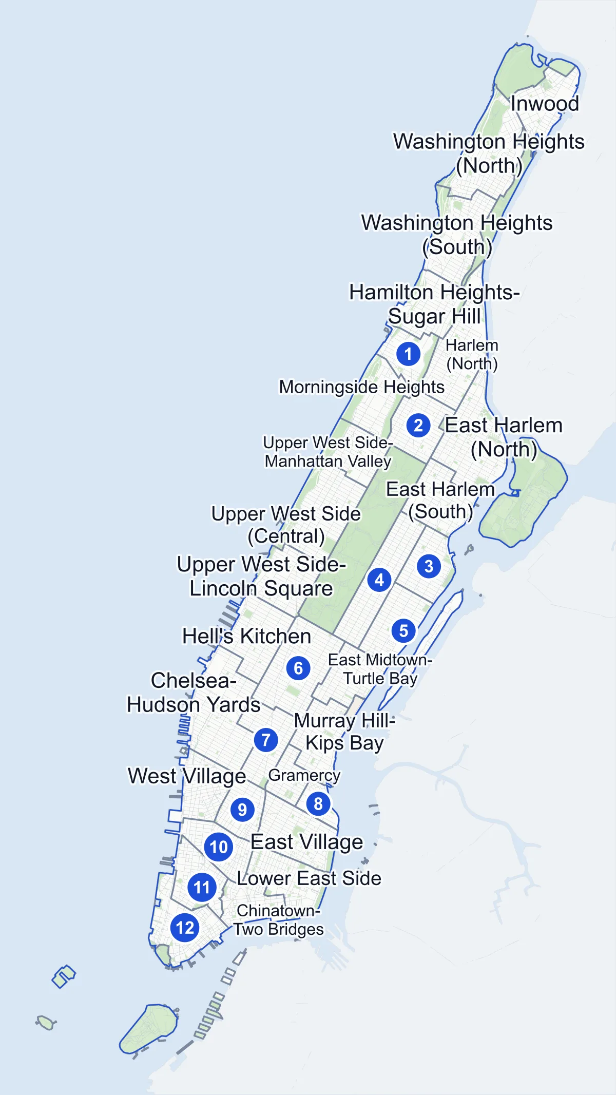
- Neighborhood
- Park
- Other area
- Another borough
- Name in the list
Neighborhood areas and streets: NYC Department of City Planning. Parks: NYC Parks.
Residential neighborhoods
- Chelsea-Hudson Yards 149 corners
- Chinatown-Two Bridges 112 corners
- East Harlem (North) 176 corners
- East Harlem (South) 113 corners
- East Midtown-Turtle Bay 91 corners
- East Village 123 corners
- Financial District-Battery Park City 228 corners
- Gramercy 62 corners
- Greenwich Village 97 corners
- Hamilton Heights-Sugar Hill 102 corners
- Harlem (North) 128 corners
- Harlem (South) 89 corners
- Hell's Kitchen 93 corners
- Inwood 89 corners
- Lower East Side 127 corners
- Manhattanville-West Harlem 67 corners
- Midtown South-Flatiron-Union Square 96 corners
- Midtown-Times Square 162 corners
- Morningside Heights 72 corners
- Murray Hill-Kips Bay 118 corners
- SoHo-Little Italy-Hudson Square 126 corners
- Stuyvesant Town-Peter Cooper Village 13 corners
- Tribeca-Civic Center 165 corners
- Upper East Side-Carnegie Hill 175 corners
- Upper East Side-Lenox Hill-Roosevelt Island 115 corners
- Upper East Side-Yorkville 72 corners
- Upper West Side (Central) 145 corners
- Upper West Side-Lincoln Square 107 corners
- Upper West Side-Manhattan Valley 77 corners
- Washington Heights (North) 166 corners
- Washington Heights (South) 172 corners
- West Village 162 corners
Parks and other areas
six areas
- Central Park 61 corners
- Highbridge Park 11 corners
- Inwood Hill Park one corner
- Randall's Island 90 corners
- The Battery-Governors Island-Ellis Island-Liberty Island 77 corners
- United Nations three corners
An area drawn in the Bronx
one area
City Planning draws this area in the Bronx, but some of its street corners are in Manhattan.
- Kingsbridge-Marble Hill 17 corners
Safety record
The median Manhattan corner had ten police-reported crashes between 2021 and 2025, the highest median of any borough.
- 54,233 police-reported crashes at Manhattan's corners
- 2,020 corners with a signal or safety change
- 261 Barnes Dance crossings Most of any borough
At a Barnes Dance crossing, traffic stops in all directions at once and people on foot get a time of their own to cross.
Public safety
How complaints are countedWithin Manhattan's precincts the NYPD recorded 30,291 major felonies in 2025, setting aside complaints that fall under the Department of Correction's jurisdiction.
Because the count follows the NYPD's precincts, Marble Hill is counted with the Bronx, in the 50th Precinct, and Roosevelt Island with Queens, in the 114th Precinct.
Camera tickets
In 2025, bus lanes took a larger share of Manhattan's camera tickets than of any other borough's.
- 18,678 red-light camera tickets at 15 corners on the list Fewest of any borough
- 276,538 school-zone speed camera tickets at 157 corners on the list
- 257,596 bus-lane camera tickets at 66 corners on the list Most corners of any borough
The busiest corners
- West Street & Leroy Street
- 17,918 school-zone speed camera tickets, the most of any Manhattan corner on the list
- 5th Avenue & 14th Street
- 29,462 bus-lane camera tickets, the most of any Manhattan corner on the list
Manhattan's corners on the city-wide camera-ticket lists: Red-light camera tickets · School-zone speed camera tickets · Bus-lane camera tickets
Parks and landmarks
Central Park is the largest of Manhattan's 371 parks, ahead of Randall's Island Park and Riverside Park.
- 59 historic districts drawn by the Landmarks Preservation Commission Most of any borough
- 98,465 trees in NYC Parks' records
Elevation
Manhattan's street corners stand between 3 feet and 257 feet above sea level.
- Highest
- Pinehurst Avenue & West 185th Street, in Washington Heights (North)
- Lowest, a tie
- South Street & Beekman Street in Financial District-Battery Park City and Grand Street & West Broadway in SoHo-Little Italy-Hudson Square
Streets
There are 957 streets in Manhattan with two or more intersections, each listing its corners in order along the road.
Questions about Manhattan
How many neighborhoods are in Manhattan? City Planning's 2020 map draws 38 neighborhood areas in Manhattan, 32 of them residential. Marble Hill, the part of Manhattan on the mainland, is mapped with the Bronx, in Kingsbridge-Marble Hill.
How many intersections are in Manhattan? This site counts 4,050 street corners in Manhattan, each with its own page.
What is Manhattan's population? The Census Bureau's estimate for July 1, 2025 is 1,664,862, a little below the 1,694,251 people the 2020 Census counted.
Sources: Manhattan (Encyclopaedia Britannica); Traffic Signals (NYC Department of Transportation); New York City: The boroughs (Encyclopaedia Britannica).
Places the City draws by name
Where a City line carries a neighborhood's name, a special zoning district or a historic district, the place has a page of its own.
- SoHo 33 corners
- NoHo 13 corners
- Little Italy 20 corners
- Hudson Square 14 corners
- Tribeca 55 corners
Elsewhere in Manhattan
One corner in Manhattan falls outside every Neighborhood Tabulation Area.