Financial District-Battery Park City
Neighborhood · Manhattan
At Manhattan's southern tip, Financial District-Battery Park City reaches from the East River and the South Street Seaport west to Battery Park City on the Hudson.
- 0.69 square miles
- 52,992 residents, 2020 Census
- 228 street corners
- 11 subway stations
- 34 bus routes
New York City began here as a Dutch settlement in the 1620s, and George Washington took the oath as the first president at Federal Hall on Wall Street, then the nation's first capitol. Battery Park City, developed under a state authority formed in 1968, sits on 1970s landfill made with soil and rock dug out for the World Trade Center, and over a third of its 92 acres is parkland. Trinity Church and One World Trade Center, opened in 2014, also stand here.
Sources: Financial District, Manhattan (Wikipedia); Federal Hall National Memorial (National Park Service); Battery Park City (Wikipedia).
Financial District-Battery Park City borders five areas, and Pearl Street holds more of its corners than any other street, 24 of 228.
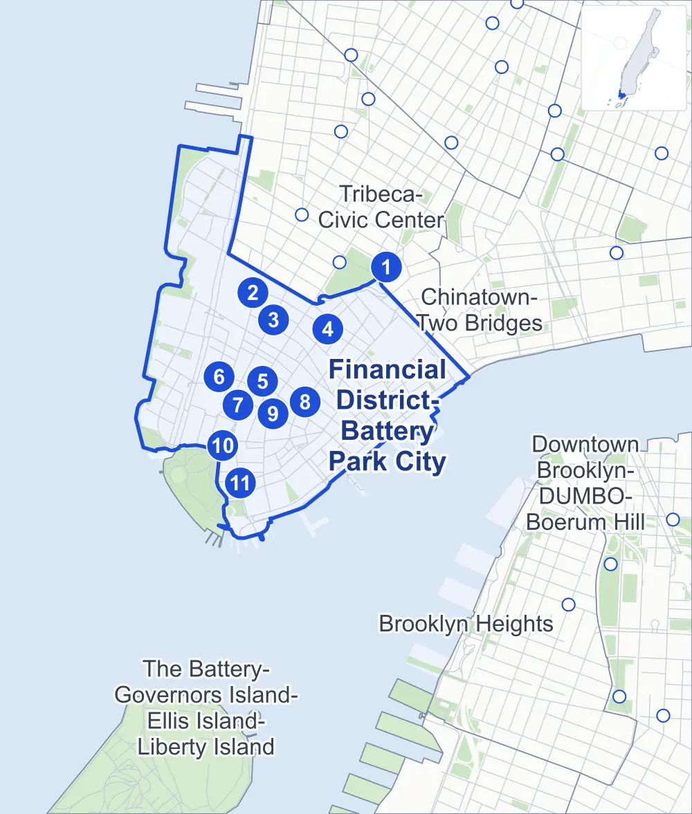
- Financial District-Battery Park City
- A neighboring area
- Park
- A station in the list
- Another station
Neighborhood areas and streets: NYC Department of City Planning. Parks: NYC Parks. Stations: MTA.
Neighboring areas
Subway stations
- Brooklyn Bridge-City Hall lines 4 5 6 accessible
- WTC Cortlandt lines 1 accessible
- Cortlandt St lines R W accessible
- Fulton St lines 2 3 4 5 A C J Z accessible
- Wall St lines 4 5
- Rector St lines 1
- Rector St lines R W
- Wall St lines 2 3
- Broad St lines J Z
- Bowling Green lines 4 5 accessible
- South Ferry / Whitehall St-South Ferry lines 1 R W
Getting around
Eleven subway stations and buses on 34 routes stop in or at the edge of Financial District-Battery Park City.
- 11 subway stations
- 5 of them listed by the MTA as fully accessible
- 7 local bus routes
- 27 express bus routes
Local bus routes
- M9
- M15
- M15-SBS
- M20
- M22
- M55
- M103
Express bus routes
- BM1
- BM2
- BM3
- BM4
- BxM18
- QM7
- QM8
- QM11
- QM25
- QM65
- SIM1
- SIM1C
- SIM2
- SIM3C
- SIM4
- SIM4C
- SIM5
- SIM7
- SIM9
- SIM15
- SIM32
- SIM33
- SIM33C
- SIM34
- SIM35
- X27
- X28
Safety record
Between 2021 and 2025, its corners averaged fewer police-reported crashes than the average Manhattan corner.
- 1,447 police-reported crashes at its corners
- 6.3 a corner, on average
- 13.4 the average Manhattan corner
- 41 corners with a clean record
Signal or safety changes on City record, at 57 of its corners
- Leading pedestrian intervals
- 28
- Accessible pedestrian signals
- 26
- Barnes Dance all-way crossings
- 25
- Safety Improvement Projects
- 4
- Turn calming
- 2
- Enhanced crossings
- 1
Camera tickets
In 2025 its corners had more school-zone speed camera tickets than bus-lane or red-light tickets.
- 0 red-light camera tickets
- 28,586 school-zone speed camera tickets at six corners
- 1,487 bus-lane camera tickets at one corner
- Most speed tickets
- West Street & Chambers Street, 11,244
- Most bus-lane tickets
- Broadway & Morris Street, 1,487
People and homes
The 2020 Census counted 52,992 residents in Financial District-Battery Park City, about 76,800 per square mile.
- 29,957 homes, 2020 Census
- 11,455 homes added since April 2010, net, by City Planning's count
Half of its 261 residential lots hold buildings from 1918 or earlier, and 67% of them date from before 1940, by the City's tax lot records.
Parks and landmarks
- Parkland
- 28.3 acres of NYC Parks property
- The largest pieces
- Battery Park City (20.5 acres), Battery Park City (1.6 acres) and the Battery (1.5 acres)
- Designated landmarks
- The J. & W. Seligman & Company Building, 90-94 Maiden Lane Building, the Delmonico's Building and the Beaver Building, among others
- Historic districts
- Fraunces Tavern Block, South Street Seaport, South Street Seaport Extension and Stone Street, wholly or partly within Financial District-Battery Park City
Streets and trees
- Trees
- 1,915 in NYC Parks' records, most often thornless honeylocust, Callery pear and littleleaf linden
- Street with the most corners
- Pearl Street, with 24 of the area's 228
- Height above sea level
- From 3 feet at South Street & Beekman Street to 39 feet at Park Row & Beekman Street
- Honorary street names
- 6 at its corners, enacted by local law
Schools and libraries
The City lists 30 schools and one library in Financial District-Battery Park City.
- Public schools
- 16
- Charter and private schools
- 14
- Library
- Battery Park City Library
Bike share and public art
By the station list of October 3, 2026, 33 bike-share stations stand in Financial District-Battery Park City. The City's public art inventory lists eight works in the area, among them Benjamin Franklin (1872), Coast Guard Memorial (1955) and Shadows and Flags (1978).
- 33 bike-share stations
- 8 works of public art
Public safety
How complaints are countedIn 2025 the NYPD recorded 654 major felonies at places in Financial District-Battery Park City.
Recorded by the NYPD at places in Financial District-Battery Park City
- 655 major felonies in 2024
- 2,145 other felonies, misdemeanors and violations in 2025
In 2025, on the streets along the edge of Financial District-Battery Park City, the NYPD recorded another 37 major felonies.
- Police precincts
- 1st (most of the area), 5th
From January to June 2026 the NYPD recorded 322 major felonies at places in Financial District-Battery Park City, against 337 in the same months of 2025.
Sources: the NYPD's Complaint Data Historic, updated April 28, 2026, and Complaint Data Current (Year To Date), updated July 27, 2026, on NYC Open Data. Figures to June 30, 2026.
Street corners
- Ann Street & Theater Alley
- Battery Park Underpass & South Street
- Battery Place & 1st Place
- Battery Place & 2nd Place
- Battery Place & 3rd Place
- Battery Place & Little West Street
- Battery Place & West Thames Street
- Beaver Street & Hanover Street
- Beaver Street & New Street
- Beekman Street & Theater Alley
- Broad Street & Beaver Street
- Broad Street & Bridge Street
- Broad Street & Exchange Place
- Broad Street & Marketfield Street
- Broad Street & Nassau Street
- Broad Street & South William Street
- Broad Street & Stone Street
- Broadway & Beaver Street
- Broadway & Cedar Street
- Broadway & Dey Street
- Broadway & Exchange Place
- Broadway & Fulton Street
- Broadway & John Street
- Broadway & Liberty Street
- Broadway & Maiden Lane
- Broadway & Morris Street
- Broadway & Pine Street
- Broadway & Rector Street
- Broadway & State Street
- Broadway & Thames Street
- Broadway & Wall Street
- Broadway & Whitehall Street
- Brooklyn Bridge & Brooklyn Bridge Pedestrian Path
- Brooklyn Bridge & East River Esplanade
- Brooklyn Bridge & FDR Drive at Brooklyn Bridge Pedestrian Path (Brooklyn Bridge)
- Brooklyn Bridge & FDR Drive at Brooklyn Bridge Pedestrian Path (Pearl Street)
- Brooklyn Bridge & FDR Drive at South Street
- Brooklyn Bridge & FDR Drive Entry Ramp
- Brooklyn Bridge & Frankfort Street
- Brooklyn Bridge & Park Row
- Brooklyn Bridge & Park Row at Brooklyn Bridge Pedestrian Path
- Brooklyn Bridge & Park Row at Spruce Street
- Brooklyn Bridge & Pearl Street
- Brooklyn Bridge & Rose Street
- Brooklyn Bridge & South Street
- Brooklyn-Battery Tunnel & Battery Place
- Chambers Street & North End Avenue
- Chambers Street & River Terrace
- Chambers Street & Tribeca Bridge
- Church Street & Cortlandt Street
- Church Street & Dey Street
- Church Street & Fulton Street
- Church Street & Liberty Street
- Church Street & Vesey Street
- East River Esplanade & Pedestrian and Bike Path Link
- Exchange Place & Hanover Street
- Exchange Place & New Street
- FDR Drive & Brooklyn Bridge
- FDR Drive Viaduct & South Street
- Frankfort Street & Gold Street
- Front Street & Beekman Street
- Front Street & Dover Street
- Front Street & Fletcher Street
- Front Street & Gouverneur Lane
- Front Street & Maiden Lane
- Front Street & Old Slip
- Front Street & Peck Slip
- Front Street & Pine Street
- Front Street & Wall Street
- Fulton Street & Cliff Street
- Fulton Street & Dutch Street
- Fulton Street & Front Street
- Fulton Street & Gold Street
- Fulton Street & Nassau Street
- Fulton Street & Ryders Alley
- Fulton Street & William Street
- Gold Street & Ann Street
- Gold Street & Beekman Street
- Gold Street & Edens Alley
- Gold Street & Platt Street
- Gold Street & Spruce Street
- Greenwich Street & Albany Street
- Greenwich Street & Battery Place
- Greenwich Street & Brooklyn Battery Tunnel Pedestrian Overpass
- Greenwich Street & Carlisle Street
- Greenwich Street & Cedar Street
- Greenwich Street & Cortlandt Way
- Greenwich Street & Edgar Street
- Greenwich Street & Fulton Street
- Greenwich Street & Liberty Street
- Greenwich Street & Rector Street
- Greenwich Street & Thames Street
- Greenwich Street & Trinity Place
- Greenwich Street & Vesey Street
- Hugh L Carey Tunnel Entrance & Albany Street
- John Street & Cliff Street
- John Street & Dutch Street
- John Street & Front Street
- John Street & Gold Street
- John Street & Nassau Street
- John Street & William Street
- Liberty Street & Liberty Place
- Liberty Street & Liberty Street Pedestrian Overpass
- Liberty Street & Maiden Lane
- Liberty Street & Nassau Street
- Liberty Street & South End Avenue
- Liberty Street & William Street
- Little West Street & 1st Place
- Little West Street & 2nd Place
- Maiden Lane & Liberty Place
- Murray Street & North End Avenue
- Murray Street & North End Way
- Murray Street & River Terrace
- Nassau Street & Ann Street
- Nassau Street & Beekman Street
- Nassau Street & Cedar Street
- Nassau Street & Maiden Lane
- Nassau Street & Pine Street
- Nassau Street & Spruce Street
- North Cove Bike Path & Battery Park City Greenway
- North End Avenue & Park Place West
- North End Avenue & River Terrace
- Park Row & Beekman Street
- Park Row & Frankfort Street
- Pearl Street & Beaver Street
- Pearl Street & Beekman Street
- Pearl Street & Broad Street
- Pearl Street & Brooklyn Bridge at FDR Drive Entry Ramp
- Pearl Street & Cedar Street
- Pearl Street & Coenties Alley
- Pearl Street & Coenties Slip
- Pearl Street & Fletcher Street
- Pearl Street & Frankfort Street
- Pearl Street & Fulton Street
- Pearl Street & Hanover Square
- Pearl Street & Hanover Street
- Pearl Street & John Street
- Pearl Street & Maiden Lane
- Pearl Street & Moore Street
- Pearl Street & Peck Slip
- Pearl Street & Pine Street
- Pearl Street & Platt Street
- Pearl Street & State Street
- Pearl Street & Wall Street
- Pearl Street & Water Street
- Pearl Street & Whitehall Street
- Pearl Street & William Street
- River Terrace & Park Place West
- South End Avenue & Albany Street
- South End Avenue & Rector Place
- South End Avenue & West Thames Street
- South Street & Beekman Street
- South Street & Broad Street
- South Street & Dover Street
- South Street & FDR Drive
- South Street & FDR Drive (Exit 1, east)
- South Street & FDR Drive (Exit 1, west)
- South Street & Fletcher Street
- South Street & Fulton Street
- South Street & Gouverneur Lane
- South Street & John Street
- South Street & Maiden Lane
- South Street & Old Slip
- South Street & Peck Slip
- South Street & Peter Minuit Place
- South Street & Pine Street
- South Street & Wall Street
- South William Street & Coenties Alley
- South William Street & Mill Lane
- State Street & Bridge Street
- State Street & Peter Minuit Place
- Stone Street & Coenties Alley
- Stone Street & Mill Lane
- Trinity Place & Cedar Street
- Trinity Place & Edgar Street
- Trinity Place & Exchange Alley
- Trinity Place & Rector Street
- Trinity Place & Thames Street
- Vesey Street & North End Avenue
- Vesey Street & North End Way
- Wall Street & Hanover Street
- Wall Street & New Street
- Warren Street & North End Avenue
- Warren Street & River Terrace
- Washington Street & Albany Street
- Washington Street & Battery Place
- Washington Street & Brooklyn Battery Tunnel Pedestrian Overpass
- Washington Street & Carlisle Street
- Washington Street & Rector Street
- Water Street & Beekman Street
- Water Street & Broad Street
- Water Street & Coenties Slip
- Water Street & Dover Street
- Water Street & Fletcher Street
- Water Street & Fulton Street
- Water Street & Gouverneur Lane
- Water Street & John Street
- Water Street & Maiden Lane
- Water Street & Moore Street
- Water Street & Old Slip
- Water Street & Old Slip at Hanover Square
- Water Street & Peck Slip
- Water Street & Pine Street
- Water Street & State Street
- Water Street & Wall Street
- West Street & Albany Street
- West Street & Battery Park Underpass
- West Street & Brooklyn-Battery Tunnel
- West Street & Chambers Street
- West Street & Liberty Street
- West Street & Liberty Street Pedestrian Overpass
- West Street & Murray Street
- West Street & Robert R Douglass Pedestrian Overpass
- West Street & Tribeca Bridge
- West Street & Vesey Street
- West Street & Warren Street
- West Thames Street & Robert R Douglass Pedestrian Overpass
- Whitehall Street & Bridge Street
- William Street & Ann Street
- William Street & Beaver Street
- William Street & Beekman Street
- William Street & Cedar Street
- William Street & Exchange Place
- William Street & Maiden Lane
- William Street & Pine Street
- William Street & Platt Street
- William Street & Spruce Street
- William Street & Wall Street
How the figures above are measured: Methodology.