The Battery-Governors Island-Ellis Island-Liberty Island
Park · Manhattan
Manhattan's southern tip and three islands make up The Battery-Governors Island-Ellis Island-Liberty Island, home to three national monuments.
- 0.43 square miles
- 77 street corners
- 2 subway stations
- 28 bus routes
Castle Clinton, built as a fort just off Manhattan's tip between 1808 and 1811, later became Castle Garden, where more than 8 million immigrants entered from 1855 to 1890, and now houses the Statue of Liberty ticket office. The statue, a gift from the people of France, was dedicated in 1886, and Ellis Island handled more than 12 million immigrants in its busiest years, 1892 to 1924. Governors Island, an Army post from 1794 to 1966, keeps Fort Jay and Castle Williams, both built between 1796 and 1811.
Sources: History & Culture - Castle Clinton National Monument (National Park Service); Statue of Liberty National Monument (National Park Service); Ellis Island Part of Statue of Liberty National Monument (National Park Service); History & Culture - Governors Island National Monument (National Park Service).
The Battery-Governors Island-Ellis Island-Liberty Island borders three areas, and Division Road holds more of its corners than any other street, 15 of 77.
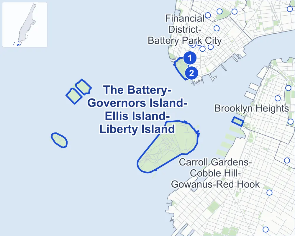
- The Battery-Governors Island-Ellis Island-Liberty Island
- A neighboring area
- Park
- A station in the list
- Another station
Neighborhood areas and streets: NYC Department of City Planning. Parks: NYC Parks. Stations: MTA.
Neighboring areas
Subway stations
- Bowling Green lines 4 5 accessible
- South Ferry lines 1 accessible
Getting around
Two subway stations and buses on 28 routes stop in or at the edge of The Battery-Governors Island-Ellis Island-Liberty Island.
- 2 subway stations
- 2 of them listed by the MTA as fully accessible
- 4 local bus routes
- 24 express bus routes
Local bus routes
- B63
- M15-SBS
- M20
- M55
Express bus routes
- BM1
- BM2
- BM3
- BM4
- BxM18
- QM7
- QM8
- QM11
- QM25
- QM65
- SIM1
- SIM1C
- SIM2
- SIM3C
- SIM4
- SIM4C
- SIM5
- SIM15
- SIM32
- SIM33C
- SIM34
- SIM35
- X27
- X28
Safety record
Between 2021 and 2025, its corners averaged fewer police-reported crashes than the average Manhattan corner.
- 6 police-reported crashes at its corners
- 0.1 a corner, on average
- 13.4 the average Manhattan corner
- 75 corners with a clean record
Camera tickets
In 2025 the Department of Finance recorded no red-light, school-zone speed or bus-lane camera ticket at its corners.
Parks and landmarks
- Parkland
- 25 acres of NYC Parks property
- The largest pieces
- The Battery (19.8 acres) and Brooklyn Bridge Park (5.2 acres)
- Designated landmarks
- The Castle Clinton; and the Interborough Rapid Transit System, Battery Park Control House
- Historic districts
- Ellis Island and Governors Island, wholly or partly within The Battery-Governors Island-Ellis Island-Liberty Island
Streets and trees
- Trees
- 461 in NYC Parks' records, most often London planetree, pin oak and willow oak
- Street with the most corners
- Division Road, with 15 of the area's 77
- Height above sea level
- From 5 feet at Craig Road North & Discovery Hill Path to 20 feet at Andes Road & Ferry Line Road
Bike share and public art
By the station list of October 3, 2026, three bike-share stations stand in The Battery-Governors Island-Ellis Island-Liberty Island. The City's public art inventory lists ten works in the area, among them John Ericsson Memorial (1903), Giovanni da Verrazzano (1909) and Battery Park Cannon (1914).
- 3 bike-share stations
- 10 works of public art
Street corners
- Andes Road & Ferry Line Road
- Andes Road & Hay Road
- Andes Road & Tampa Road
- Barry Road & Andes Road
- Barry Road & Evans Road
- Barry Road & Kimmel Road
- Battery Park Underpass & Battery Park Path
- Brooklyn-Battery Tunnel & Battery Park Underpass
- Carder Road & Ferry Line Road
- Carder Road & Hay Road
- Clayton Road & Cartigan Road
- Clayton Road & Earlybird Road
- Clayton Road & King Avenue
- Clayton Road & Owasco Road
- Clayton Road & Short Avenue
- Clayton Road & Wheeler Avenue
- Comfort Road & Evans Road
- Comfort Road & Hay Road
- Comfort Road & King Avenue
- Comfort Road & Owasco Road
- Comfort Road & Tampa Road
- Craig Road North & Absecon Road
- Craig Road North & Clayton Road
- Craig Road North & Discovery Hill Path
- Craig Road North & Division Road
- Craig Road North & East Way
- Craig Road North & Governors Island Path
- Craig Road North & Gresham Road
- Craig Road North & Outlook Way
- Craig Road South & Craig Road North
- Craig Road South & Division Road
- Craig Road South & Half Moon Road
- Craig Road South & Icarus Road
- Craig Road South & Yeaton Road
- Discovery Hill Path & Absecon Road
- Division Road & Cartigan Road
- Division Road & Center Way
- Division Road & Governors Island Path
- Division Road & Governors Island Path at Play Way
- Division Road & King Avenue
- Division Road & Owasco Road
- Division Road & Play Way (north-west)
- Division Road & Play Way (south-east)
- Division Road & Play Way at Center Way
- Division Road & Short Avenue
- Division Road & West Way
- Division Road & Wheeler Avenue
- Earlybird Road & Play Way
- Enright Road & Division Road
- Enright Road & Gresham Road
- Enright Road & Half Moon Road
- Enright Road & Icarus Road
- Enright Road & West Way
- Enright Road & Yeaton Road
- Governors Island Path & Center Way at East Way
- Governors Island Path & Center Way at The Oval
- Governors Island Path & East Way
- Governors Island Path & Hammock Grove Pedestrian Path
- Governors Island Path & Outlook Way
- Governors Island Path & The Oval
- Governors Island Path & West Way
- Gresham Road & Absecon Road
- Gresham Road & Discovery Hill Path
- Gresham Road & Outlook Hill Path
- Gresham Road & Outlook Way
- Hay Road & Clayton Road
- Hay Road & Earlybird Road
- Hay Road & Kimball Road
- Hay Road & Wheeler Avenue
- Kimmel Road & Andes Road
- Kimmel Road & Craig Road South
- Kimmel Road & Evans Road
- Outlook Way & Center Way
- Play Way & West Way
- Tampa Road & Kimball Road
- The Oval & West Way
- West Way & Hammock Grove Pedestrian Path
How the figures above are measured: Methodology.