Brooklyn Heights
Neighborhood · Brooklyn
Brooklyn Heights sits on a plateau above the East River, between Old Fulton Street, near the Brooklyn Bridge, and Atlantic Avenue.
- 0.36 square miles
- 25,092 residents, 2020 Census
- 112 street corners
- 2 subway stations
- 12 bus routes
Regular steam ferry service to Manhattan began in 1814, and from the 1820s its farms were divided into house lots, giving it a reputation as the first commuter suburb. Its Federal, Greek Revival, Gothic Revival and Anglo-Italianate houses and churches became New York City's first historic district in 1965, and the Promenade, built atop the Brooklyn-Queens Expressway, looks out on the Manhattan skyline, the Brooklyn Bridge and the Statue of Liberty.
Sources: Brooklyn Heights (Wikipedia); Brooklyn Heights Historic District (Historic Districts Council); Brooklyn Heights Historic District (The Cultural Landscape Foundation).
Brooklyn Heights borders four areas, and Hicks Street holds more of its corners than any other street, 17 of 112.
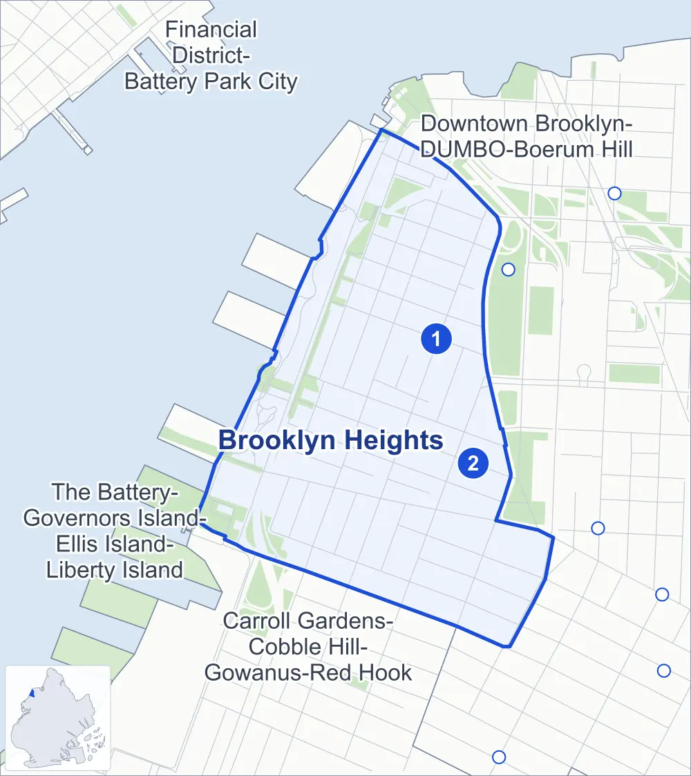
- Brooklyn Heights
- A neighboring area
- Park
- A station in the list
- Another station
Neighborhood areas and streets: NYC Department of City Planning. Parks: NYC Parks. Stations: MTA.
Neighboring areas
Subway stations
- Clark St lines 2 3
- Borough Hall / Court St lines 4 5 R
Getting around
Two subway stations and buses on 12 routes stop in or at the edge of Brooklyn Heights.
- 2 subway stations
- 12 local bus routes
Local bus routes
- B25
- B26
- B38
- B41
- B45
- B52
- B57
- B61
- B63
- B65
- B93
- B103
Safety record
Between 2021 and 2025, its corners averaged fewer police-reported crashes than the average Brooklyn corner.
- 865 police-reported crashes at its corners
- 7.7 a corner, on average
- 10.5 the average Brooklyn corner
- 19 corners with a clean record
Signal or safety changes on City record, at 21 of its corners
- Accessible pedestrian signals
- 13
- Leading pedestrian intervals
- 8
- Barnes Dance all-way crossings
- 3
- Safety Improvement Projects
- 3
- Turn calming
- 2
Camera tickets
In 2025 its corners had more school-zone speed camera tickets than red-light or bus-lane tickets.
- 0 red-light camera tickets
- 10,254 school-zone speed camera tickets at four corners
- 0 bus-lane camera tickets
- Most speed tickets
- Furman Street & Montague Street, 5,857
People and homes
The 2020 Census counted 25,092 residents in Brooklyn Heights, about 69,700 per square mile.
- 13,810 homes, 2020 Census
- 1,342 homes added since April 2010, net, by City Planning's count
Half of its 1,264 residential lots hold buildings from 1860 or earlier, and 95% of them date from before 1940, by the City's tax lot records.
Parks and landmarks
- Parkland
- 12.8 acres of NYC Parks property
- The largest pieces
- Brooklyn Bridge Park (5.1 acres), Adam Yauch Park (1.4 acres) and Hillside Dog Park (1.3 acres)
- Designated landmarks
- The Brooklyn Trust Company Building, the National Title Guaranty Company, the People's Trust Company Building and the Brooklyn Union Gas Company Building
- Historic districts
- Borough Hall Skyscraper and Brooklyn Heights, wholly or partly within Brooklyn Heights
Streets and trees
- Trees
- 1,897 in NYC Parks' records, most often thornless honeylocust, London planetree and maidenhair tree
- Street with the most corners
- Hicks Street, with 17 of the area's 112
- Height above sea level
- From 6 feet at Joralemon Street & Bridge Park Drive to 88 feet at Henry Street & Love Lane
- Honorary street name
- 1 at its corners, enacted by local law
Schools and libraries
The City lists 11 schools and two libraries in Brooklyn Heights.
- Public school
- 1
- Charter and private schools
- 10
- Libraries
- Brooklyn Heights Library and Center for Brooklyn History
Bike share
By the station list of October 3, 2026, 12 bike-share stations stand in Brooklyn Heights.
- 12 bike-share stations
Public safety
How complaints are countedIn 2025 the NYPD recorded 250 major felonies at places in Brooklyn Heights.
Recorded by the NYPD at places in Brooklyn Heights
- 244 major felonies in 2024
- 470 other felonies, misdemeanors and violations in 2025
In 2025, on the streets along the edge of Brooklyn Heights, the NYPD recorded another 73 major felonies. Counting the streets along its edge, in 2025 the NYPD recorded 12.9 major felonies for every thousand residents the 2020 Census counted in Brooklyn Heights.
- Police precinct
- 84th
From January to June 2026 the NYPD recorded 100 major felonies at places in Brooklyn Heights, against 129 in the same months of 2025.
Sources: the NYPD's Complaint Data Historic, updated April 28, 2026, and Complaint Data Current (Year To Date), updated July 27, 2026, on NYC Open Data. Figures to June 30, 2026.
Street corners
- Atlantic Avenue & Boerum Place
- Atlantic Avenue & Brooklyn-Queens Expressway
- Atlantic Avenue & Brooklyn-Queens Expressway (Exit 27)
- Atlantic Avenue & Columbia Street
- Atlantic Avenue & Columbia Street at Furman Street
- Atlantic Avenue & Furman Street
- Bridge Park Drive & Brooklyn Bridge Park Path
- Brooklyn-Queens Expressway & Atlantic Avenue
- Brooklyn-Queens Expressway & Columbia Heights
- Brooklyn-Queens Expressway & Joralemon Street
- Brooklyn-Queens Expressway & Middagh Street
- Brooklyn-Queens Expressway & Vine Street
- Cadman Plaza West & Middagh Street
- Cadman Plaza West & Pierrepont Street
- Clark Street & Brooklyn Heights Promenade
- Clark Street & Monroe Place
- Clark Street & Willow Street
- Clinton Street & Joralemon Street
- Clinton Street & Livingston Street
- Clinton Street & Montague Street
- Clinton Street & Pierrepont Street
- Clinton Street & Remsen Street
- Clinton Street & Schermerhorn Street
- Clinton Street & State Street
- College Place & Love Lane
- Columbia Heights & Brooklyn Heights Promenade
- Columbia Heights & Clark Street
- Columbia Heights & Cranberry Street
- Columbia Heights & Doughty Street
- Columbia Heights & Middagh Street
- Columbia Heights & Orange Street
- Columbia Heights & Pierrepont Street
- Columbia Heights & Pineapple Street
- Columbia Heights & Squibb Park and Bridge Path
- Columbia Heights & Vine Street
- Court Street & Cadman Plaza West
- Court Street & Joralemon Street
- Court Street & Livingston Street
- Court Street & Remsen Street
- Court Street & Schermerhorn Street
- Court Street & State Street
- Doughty Street & Elizabeth Place
- Doughty Street & McKenny Street
- Front Street & Old Fulton Street
- Front Street & Old Fulton Street at Brooklyn-Queens Expressway
- Fulton Street & Adams Street
- Furman Street & Doughty Street
- Furman Street & Joralemon Street
- Furman Street & Montague Street
- Furman Street & Old Fulton Street
- Furman Street & Squibb Park Bridge
- Henry Street & Clark Street
- Henry Street & Cranberry Street
- Henry Street & Hunts Lane
- Henry Street & Joralemon Street
- Henry Street & Love Lane
- Henry Street & Middagh Street
- Henry Street & Montague Street
- Henry Street & Orange Street
- Henry Street & Pierrepont Street
- Henry Street & Pineapple Street
- Henry Street & Poplar Street
- Henry Street & Remsen Street
- Henry Street & State Street
- Hicks Street & Brooklyn-Queens Expressway
- Hicks Street & Brooklyn-Queens Expressway at Doughty Street
- Hicks Street & Clark Street
- Hicks Street & Cranberry Street
- Hicks Street & Grace Court
- Hicks Street & Grace Court Alley
- Hicks Street & Joralemon Street
- Hicks Street & Love Lane
- Hicks Street & Middagh Street
- Hicks Street & Montague Street
- Hicks Street & Old Fulton Street
- Hicks Street & Orange Street
- Hicks Street & Pierrepont Street
- Hicks Street & Pineapple Street
- Hicks Street & Poplar Street
- Hicks Street & Remsen Street
- Hicks Street & State Street
- Joralemon Street & Borough Hall Pedestrian Path
- Joralemon Street & Bridge Park Drive
- Joralemon Street & Columbia Place
- Joralemon Street & Garden Place
- Joralemon Street & Sidney Place
- Joralemon Street & Willow Place
- Livingston Street & Boerum Place
- Montague Street & Brooklyn Heights Promenade
- Montague Street & Pierrepont Place
- Old Fulton Street & Brooklyn-Queens Expressway
- Pierrepont Street & Brooklyn Heights Promenade
- Pierrepont Street & Monroe Place
- Pierrepont Street & Pierrepont Place
- Pierrepont Street & Willow Street
- Pineapple Street & Brooklyn Heights Promenade
- Remsen Street & Brooklyn Heights Promenade
- Remsen Street & Montague Terrace
- Schermerhorn Street & Boerum Place
- Sidney Place & Aitken Place
- Squibb Park and Bridge Path & Squibb Park Bridge
- State Street & Boerum Place
- State Street & Columbia Place
- State Street & Garden Place
- State Street & Sidney Place
- State Street & Willow Place
- Tillary Street & Cadman Plaza West
- Water Street & Old Fulton Street
- Willow Street & Cranberry Street
- Willow Street & Middagh Street
- Willow Street & Orange Street
- Willow Street & Pineapple Street
How the figures above are measured: Methodology.