Staten Island
Staten Island is the one borough whose population has grown since the 2020 Census, when it counted 495,747 residents.
- 7,067 street corners
- 16 residential neighborhoods
- 58.2 square miles of land
- 501,290 residents Census Bureau estimate, July 1, 2025
It was named for the States General of the Dutch Republic, joined New York City in 1898 as the borough of Richmond, and took the name Staten Island in 1975.
Neighborhoods
Open the map full sizeThe island's street corners are spread over 21 neighborhood areas. Annadale-Huguenot-Prince's Bay-Woodrow has more of them than any neighborhood area in the city: 792.
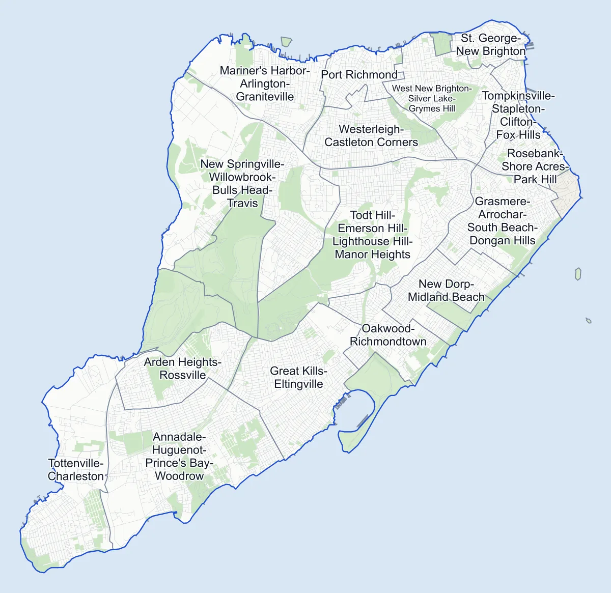
- Neighborhood
- Park
- Other area
Neighborhood areas and streets: NYC Department of City Planning. Parks: NYC Parks.
Residential neighborhoods
- Annadale-Huguenot-Prince's Bay-Woodrow 792 corners
- Arden Heights-Rossville 356 corners
- Grasmere-Arrochar-South Beach-Dongan Hills 475 corners
- Great Kills-Eltingville 752 corners
- Mariner's Harbor-Arlington-Graniteville 337 corners
- New Dorp-Midland Beach 414 corners
- New Springville-Willowbrook-Bulls Head-Travis 503 corners
- Oakwood-Richmondtown 370 corners
- Port Richmond 260 corners
- Rosebank-Shore Acres-Park Hill 298 corners
- St. George-New Brighton 184 corners
- Todt Hill-Emerson Hill-Lighthouse Hill-Manor Heights 633 corners
- Tompkinsville-Stapleton-Clifton-Fox Hills 187 corners
- Tottenville-Charleston 367 corners
- West New Brighton-Silver Lake-Grymes Hill 488 corners
- Westerleigh-Castleton Corners 584 corners
Parks and other areas
five areas
- Fort Wadsworth 48 corners
- Freshkills Park (North) three corners
- Freshkills Park (South) five corners
- Great Kills Park five corners
- Snug Harbor six corners
Elevation
Three corners on Ocean Terrace, in Todt Hill-Emerson Hill-Lighthouse Hill-Manor Heights, stand 396 feet above sea level, higher than any other corner in the City's elevation survey.
- The three highest
- Ocean Terrace at Elmhurst Avenue, Dresden Place and Tiber Place
- The three lowest
- Seaver Avenue & Quincy Avenue, Quincy Avenue & Sioux Street and Patterson Avenue & Graham Boulevard, in New Dorp-Midland Beach, 1 foot above sea level
Getting around
The Staten Island Railway is the island's train line, running from St. George to Tottenville.
- 21 Staten Island Railway stations
- 58 bus routes with stops on the island Express routes to Manhattan among them
Safety record
Almost half of the island's corners went without a police-reported crash between 2021 and 2025, the largest share of any borough.
- 46% of its corners with a clean record
- 15,656 police-reported crashes in all
- 1 crash count at the median corner
- 581 corners with a signal or safety change
Accessible pedestrian signals, which sound and vibrate for people who are blind or have low vision, are the change made most often.
Public safety
How complaints are countedOn Staten Island the NYPD recorded 3,466 major felonies in 2025.
Camera tickets
Bus-lane camera tickets are rare on Staten Island: in 2025 the lists named two corners, both on Hylan Boulevard.
- 60,840 red-light camera tickets at 28 corners on the list
- 411,855 school-zone speed camera tickets at 250 corners on the list
- 1,461 bus-lane camera tickets at two corners on the list
Forest Avenue & Willow Road West had the island's most school-zone speed camera tickets on the list: 28,036.
Staten Island's corners on the city-wide camera-ticket lists: Red-light camera tickets · School-zone speed camera tickets · Bus-lane camera tickets
Parks and trees
Freshkills Park is the island's largest park, followed by LaTourette Park & Golf Course and the Franklin D. Roosevelt Boardwalk and Beach.
- 139 parks
- 125,403 trees in NYC Parks' records
Streets
There are 2,530 streets in Staten Island with two or more intersections, each listing its corners in order along the road.
Questions about Staten Island
How many neighborhoods are on Staten Island? On City Planning's 2020 map the island has 23 areas, 16 of them residential neighborhoods.
What is the highest street corner on Staten Island? Ocean Terrace has three, tied at 396 feet, and no corner in the city is higher.
Is Staten Island's population growing? Yes, slightly. The island had 495,747 residents in the 2020 Census and 501,290 in the bureau's estimate for July 1, 2025.
Sources: Staten Island (Encyclopaedia Britannica); Traffic Signals (NYC Department of Transportation).