Grasmere-Arrochar-South Beach-Dongan Hills
Neighborhood · Staten Island
Grasmere-Arrochar-South Beach-Dongan Hills runs along Staten Island's East Shore just south of the Verrazzano-Narrows Bridge, taking in Arrochar, South Beach, Grasmere, Concord, Old Town and Dongan Hills.
- 2.87 square miles
- 36,259 residents, 2020 Census
- 475 street corners
- 3 Staten Island Railway stations
- 23 bus routes
Arrochar was named in the 1840s by an estate owner for his hometown in Scotland, and Dongan Hills honors Thomas Dongan, an Irish-born governor of colonial New York. By the mid-1880s South Beach had become a resort with a boardwalk, a carousel and rides, and in the 1930s the Works Progress Administration built a 2.5-mile boardwalk along the shore, dedicated to Franklin D. Roosevelt in 1939.
Sources: F.D.R. Boardwalk - Staten Island NY (The Living New Deal); South Beach, Staten Island (Wikipedia); Arrochar, Staten Island (Wikipedia); Dongan Hills, Staten Island (Wikipedia).
Grasmere-Arrochar-South Beach-Dongan Hills borders four areas, and Hylan Boulevard holds more of its corners than any other street, 43 of 475.
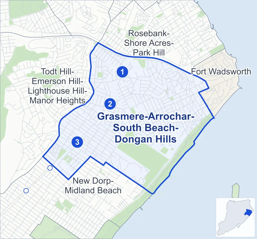
- Grasmere-Arrochar-South Beach-Dongan Hills
- A neighboring area
- Park
- A station in the list
- Another station
Neighborhood areas and streets: NYC Department of City Planning. Parks: NYC Parks. Stations: MTA.
Neighboring areas
Staten Island Railway stations
- Grasmere lines SIR
- Old Town lines SIR
- Dongan Hills lines SIR accessible
Getting around
The Staten Island Railway stops at Dongan Hills, Grasmere and Old Town, and buses on 23 routes stop in or at the edge of Grasmere-Arrochar-South Beach-Dongan Hills.
- 3 Staten Island Railway stations
- 1 of them listed by the MTA as fully accessible
- 11 local bus routes
- 12 express bus routes
Local bus routes
- S51
- S52
- S53
- S74
- S76
- S78
- S79-SBS
- S81
- S84
- S86
- S93
Express bus routes
- SIM1
- SIM1C
- SIM3C
- SIM5
- SIM6
- SIM7
- SIM9
- SIM10
- SIM11
- SIM15
- SIM33C
- SIM35
Safety record
Between 2021 and 2025, its corners averaged more police-reported crashes than the average Staten Island corner.
- 1,445 police-reported crashes at its corners
- 3.0 a corner, on average
- 2.2 the average Staten Island corner
- 171 corners with a clean record
Signal or safety changes on City record, at 44 of its corners
- Accessible pedestrian signals
- 43
- Leading pedestrian intervals
- 15
- Turn calming
- 2
- Safety Improvement Projects
- 2
- Barnes Dance all-way crossings
- 1
- Enhanced crossings
- 1
Camera tickets
In 2025 its corners had more school-zone speed camera tickets than red-light or bus-lane tickets.
- 6,053 red-light camera tickets at two corners
- 30,132 school-zone speed camera tickets at 22 corners
- 0 bus-lane camera tickets
- Most red-light tickets
- Hylan Boulevard & Narrows Road South at Staten Island Expressway, 4,212
- Most speed tickets
- Seaview Avenue & Mason Avenue, 7,186
People and homes
The 2020 Census counted 36,259 residents in Grasmere-Arrochar-South Beach-Dongan Hills, about 12,600 per square mile.
- 13,492 homes, 2020 Census
- 517 homes added since April 2010, net, by City Planning's count
Half of its 7,660 residential lots hold buildings from 1965 or earlier, and 19% of them date from before 1940, by the City's tax lot records.
NYCHA developments
NYCHA's Berry and South Beach developments lie wholly or partly within Grasmere-Arrochar-South Beach-Dongan Hills.
Parks and landmarks
- Parkland
- 259.1 acres of NYC Parks property
- The largest pieces
- Ocean Breeze Park (136.6 acres), Franklin D. Roosevelt Boardwalk and Beach (94.8 acres) and Bradys Pond Park (6.4 acres)
- Designated landmark
- The Pierre Billiou House
Streets and trees
- Trees
- 7,395 in NYC Parks' records, most often Callery pear, London planetree and pin oak
- Street with the most corners
- Hylan Boulevard, with 43 of the area's 475
- Height above sea level
- From 3 feet at Alex Circle & Doty Avenue to 148 feet at Vista Place & Piedmont Avenue
- Honorary street names
- 40 at its corners, enacted by local law
Schools and libraries
The City lists 15 schools and one library in Grasmere-Arrochar-South Beach-Dongan Hills.
- Public schools
- 7
- Charter and private schools
- 8
- Library
- South Beach Library
Public art
The City's public art inventory lists three works in Grasmere-Arrochar-South Beach-Dongan Hills: Concord World War II Memorial (1947), Father Capodanno Memorial (1976) and Fountain of the Dolphins (1998).
- 3 works of public art
Public safety
How complaints are countedIn 2025 the NYPD recorded 245 major felonies at places in Grasmere-Arrochar-South Beach-Dongan Hills.
Recorded by the NYPD at places in Grasmere-Arrochar-South Beach-Dongan Hills
- 239 major felonies in 2024
- 1,215 other felonies, misdemeanors and violations in 2025
In 2025, on the streets along the edge of Grasmere-Arrochar-South Beach-Dongan Hills, the NYPD recorded another 40 major felonies. Counting the streets along its edge, in 2025 the NYPD recorded 7.9 major felonies for every thousand residents the 2020 Census counted in Grasmere-Arrochar-South Beach-Dongan Hills.
- Police precinct
- 122nd
From January to June 2026 the NYPD recorded 106 major felonies at places in Grasmere-Arrochar-South Beach-Dongan Hills, against 129 in the same months of 2025.
Sources: the NYPD's Complaint Data Historic, updated April 28, 2026, and Complaint Data Current (Year To Date), updated July 27, 2026, on NYC Open Data. Figures to June 30, 2026.
Street corners
- Alex Circle & Doty Avenue
- Allendale Road & Normalee Road
- Alter Avenue & Bear Street
- Alter Avenue & Hancock Street
- Alter Avenue & Henry Place
- Alter Avenue & Jefferson Street
- Alter Avenue & Plattsburg Street
- Arthur Avenue & Cedar Avenue
- Atlantic Avenue & Bear Street
- Atlantic Avenue & Henry Place
- Atlantic Avenue & Johnson Place
- Austin Avenue & Retner Street
- Benton Avenue & Cooper Avenue
- Benton Avenue & Hurlbert Street
- Benton Avenue & Jerome Road
- Beverly Road & Allendale Road
- Beverly Road & Briarcliff Road
- Bionia Avenue & Foch Avenue
- Bionia Avenue & Kramer Street
- Britton Avenue & Alan Loop
- Britton Avenue & Baltic Avenue
- Britton Avenue & Hay Street
- Buel Avenue & Husson Street
- Buel Avenue & Jefferson Street
- Buel Avenue & Zoe Street
- Burgher Avenue & Adele Street
- Burgher Avenue & Bear Street
- Burgher Avenue & Henry Place
- Burgher Avenue & Johnson Place
- Burgher Avenue & Remsen Street
- Cameron Avenue & Oberlin Street
- Cedar Avenue & Austin Avenue
- Cedar Avenue & Conger Street
- Cedar Avenue & Railroad Avenue
- Cedar Avenue & Wallace Avenue
- Cedar Avenue & Windom Avenue
- Chicago Avenue & Columbia Avenue
- Cleveland Place & Brown Place
- Cleveland Place & Garson Avenue
- Cleveland Place & St John Villa Academy Driveway
- Clove Road & Britton Avenue
- Clove Road & Crist Street
- Clove Road & Elbe Avenue
- Clove Road & Fayette Avenue
- Clove Road & Giles Place
- Clove Road & Hanover Avenue
- Clove Road & Hillcrest Terrace
- Clove Road & Lakeview Terrace
- Clove Road & Leslie Avenue
- Clove Road & Mosel Avenue
- Clove Road & Neckar Avenue
- Clove Road & Normalee Road
- Clove Road & Oder Avenue
- Clove Road & Rhine Avenue
- Clove Road & Targee Street
- Clove Road & Weser Avenue
- Clove Road & West Fingerboard Road
- Clove Road & Whitney Avenue
- Clove Road & Windermere Road
- Columbia Avenue & Chicago Alley
- Cornelia Street & Minna Street
- Cromwell Avenue & Hancock Street
- Cromwell Avenue & Henry Place
- Cromwell Avenue & Jefferson Street
- Cromwell Avenue & Plattsburg Street
- Dawson Place & Academy of St Dorothy Driveway
- Delaware Avenue & Bear Street
- Delaware Avenue & Henry Place
- Delaware Avenue & Plattsburg Street
- Dongan Hills Avenue & Cletus Street
- Dongan Hills Avenue & Husson Street
- Dongan Hills Avenue & Jefferson Street
- Dongan Hills Avenue & Vera Street
- Dongan Hills Avenue & Zoe Street
- Dumont Avenue & Oregon Road
- Elbe Avenue & Sable Avenue
- Evergreen Avenue & Adele Street
- Evergreen Avenue & Hurlbert Street
- Evergreen Avenue & Jerome Road
- Evergreen Avenue & Minna Street
- Evergreen Avenue & Remsen Street
- Father Capodanno Boulevard & Doty Avenue
- Father Capodanno Boulevard & Drury Avenue
- Father Capodanno Boulevard & Ocean Avenue
- Father Capodanno Boulevard & Sand Lane
- Father Capodanno Boulevard & Seaview Avenue
- Fayette Avenue & Woodlawn Avenue
- Fingerboard Road & Cleveland Place
- Fingerboard Road & Columbia Avenue
- Fingerboard Road & Grasmere Drive
- Fingerboard Road & Hillbrook Drive
- Fingerboard Road & Impala Court
- Foch Avenue & Hickory Avenue
- Foch Avenue & Linwood Avenue
- Foch Avenue & Piave Avenue
- Garretson Avenue & Hancock Street
- Garretson Avenue & Henry Place
- Garretson Avenue & Jefferson Street
- Garretson Avenue & Magnolia Avenue
- Garretson Avenue & Plattsburg Street
- Garretson Avenue & Simpson Street
- Garretson Lane & Cobblers Lane
- Garretson Lane & Grasmere Avenue
- Gateway Drive & Pamela Lane
- Grasmere Avenue & Crist Street
- Grasmere Avenue & Giles Place
- Grasmere Drive & Claradon Lane
- Grasmere Drive & Dogwood Lane
- Grasmere Drive & Joseph Lane
- Henry Place & Perine Avenue
- Hillbrook Drive & Claradon Lane
- Hillbrook Drive & Dogwood Lane
- Hillcrest Terrace & Hillcrest Court
- Hurlbert Street & McDermott Avenue
- Hurlbert Street & Ruth Place
- Hurlbert Street & Xenia Street
- Hylan Boulevard & Academy of St Dorothy Driveway (north-east)
- Hylan Boulevard & Academy of St Dorothy Driveway (south-west)
- Hylan Boulevard & Alter Avenue
- Hylan Boulevard & Bath Avenue
- Hylan Boulevard & Benton Avenue
- Hylan Boulevard & Bionia Avenue
- Hylan Boulevard & Briarcliff Road
- Hylan Boulevard & Buel Avenue
- Hylan Boulevard & Burgher Avenue
- Hylan Boulevard & Clove Road at Norway Avenue
- Hylan Boulevard & Clove Road at Woodlawn Avenue
- Hylan Boulevard & Cooper Avenue
- Hylan Boulevard & Cromwell Avenue
- Hylan Boulevard & Delaware Avenue
- Hylan Boulevard & Evergreen Avenue
- Hylan Boulevard & Fingerboard Road
- Hylan Boulevard & Garretson Avenue
- Hylan Boulevard & Hickory Avenue
- Hylan Boulevard & Kramer Street
- Hylan Boulevard & Liberty Avenue
- Hylan Boulevard & Linwood Avenue
- Hylan Boulevard & Manorville Court
- Hylan Boulevard & Narrows Road South
- Hylan Boulevard & Narrows Road South at Staten Island Expressway
- Hylan Boulevard & Olga Place (east)
- Hylan Boulevard & Olga Place (west)
- Hylan Boulevard & Parkinson Avenue
- Hylan Boulevard & Piedmont Avenue
- Hylan Boulevard & Quintard Street
- Hylan Boulevard & Raritan Avenue
- Hylan Boulevard & Reid Avenue
- Hylan Boulevard & Roderick Avenue
- Hylan Boulevard & Sand Lane
- Hylan Boulevard & Seaver Avenue
- Hylan Boulevard & Seaview Avenue
- Hylan Boulevard & St Joseph Hill Academy Driveway
- Hylan Boulevard & Staten Island Expressway
- Hylan Boulevard & Steuben Street at Kensington Avenue
- Hylan Boulevard & Steuben Street at Olga Place
- Hylan Boulevard & Stobe Avenue
- Hylan Boulevard & West Fingerboard Road
- Hylan Boulevard & West Fingerboard Road at Sand Lane
- Hylan Boulevard & Windermere Road
- Jackson Avenue & Cedar Avenue
- Jackson Avenue & Retner Street
- Jefferson Avenue & Husson Street
- Jerome Avenue & Foch Avenue
- Jerome Avenue & Kramer Street
- Kensington Avenue & Foch Avenue
- Kensington Avenue & Kramer Street
- Laconia Avenue & Alter Avenue
- Laconia Avenue & Atlantic Avenue
- Laconia Avenue & Benton Avenue
- Laconia Avenue & Burgher Avenue
- Laconia Avenue & Cromwell Avenue
- Laconia Avenue & Delaware Avenue
- Laconia Avenue & Evergreen Avenue
- Laconia Avenue & Garretson Avenue
- Laconia Avenue & Quintard Street
- Laconia Avenue & Raritan Avenue
- Laconia Avenue & Reid Avenue
- Lakeview Terrace & Hillcrest Court
- Lakeview Terrace & Lakeside Place
- Lamport Boulevard & Foch Avenue
- Lamport Boulevard & Kramer Street
- Landis Avenue & Cleveland Place
- Landis Avenue & Knauth Place
- Landis Avenue & Pickersgill Avenue
- Landis Avenue & St John Villa Academy Driveway
- Lansing Street & Balfour Street
- Lansing Street & Orlando Street
- Lansing Street & South Beach Avenue
- Liberty Avenue & Husson Street
- Liberty Avenue & Jefferson Street
- Liberty Avenue & Magnolia Avenue
- Liberty Avenue & Simpson Street
- Liberty Avenue & Zoe Street
- Lily Pond Avenue & Galesville Court
- Lily Pond Avenue & Verrazzano-Narrows Bridge (north)
- Lily Pond Avenue & Verrazzano-Narrows Bridge (south)
- Linwood Avenue & Cambria Street
- Linwood Avenue & Diaz Street
- Linwood Avenue & Pershing Street
- Macfarland Avenue & Hastings Street
- Macfarland Avenue & Linwood Avenue
- Macfarland Avenue & Wallace Avenue
- Major Avenue & Duer Avenue
- Major Avenue & Florida Avenue
- Major Avenue & Hastings Street
- Major Avenue & Hastings Street at Landis Avenue
- Major Avenue & Lily Pond Avenue
- Major Avenue & Linwood Avenue
- Major Avenue & Sand Lane
- Major Avenue & Savo Lane
- Major Avenue & St Joseph Hill Academy Driveway
- Major Avenue & Wallace Avenue
- Mallory Avenue & Foch Avenue
- Mallory Avenue & Kramer Street
- Mallory Avenue & Lava Street
- Mason Avenue & Alter Avenue
- Mason Avenue & Burgher Avenue
- Mason Avenue & Cromwell Avenue
- Mason Avenue & Dea Court
- Mason Avenue & Delaware Avenue
- Mason Avenue & Garretson Avenue
- Mason Avenue & Quintard Street
- Mason Avenue & Raritan Avenue
- Mason Avenue & Ruth Place
- Mason Avenue & Xenia Street
- McClean Avenue & Arthur Avenue
- McClean Avenue & Bionia Avenue
- McClean Avenue & Conger Street
- McClean Avenue & Florida Avenue
- McClean Avenue & Hastings Street
- McClean Avenue & Hickory Avenue
- McClean Avenue & Jackson Avenue
- McClean Avenue & Jerome Avenue
- McClean Avenue & Kensington Avenue
- McClean Avenue & Lamport Boulevard
- McClean Avenue & Lily Pond Avenue
- McClean Avenue & Linwood Avenue
- McClean Avenue & Mallory Avenue
- McClean Avenue & Mills Avenue
- McClean Avenue & Norway Avenue
- McClean Avenue & Norway Avenue at Reid Avenue
- McClean Avenue & Ocean Avenue
- McClean Avenue & Pebble Lane
- McClean Avenue & Piave Avenue
- McClean Avenue & Railroad Avenue
- McClean Avenue & Sand Lane
- McClean Avenue & Wallace Avenue
- Mills Avenue & Cedar Avenue
- Mosel Avenue & Grasmere Avenue
- Mosel Avenue & Sable Avenue
- Mosel Avenue & Sheridan Avenue
- Narrows Road South & Britton Avenue
- Narrows Road South & Fingerboard Road
- Narrows Road South & Grasmere Drive
- Narrows Road South & Hanover Avenue
- Narrows Road South & Hastings Street
- Narrows Road South & Legion Place
- Narrows Road South & Lily Pond Avenue
- Narrows Road South & Mosel Avenue
- Narrows Road South & Neckar Avenue
- Narrows Road South & Oder Avenue
- Narrows Road South & Savo Lane
- Narrows Road South & Staten Island Expressway
- Narrows Road South & Verrazzano-Narrows Bridge
- Narrows Road South & Weser Avenue
- Naughton Avenue & Cletus Street
- Naughton Avenue & Husson Street
- Naughton Avenue & Joyce Street
- Naughton Avenue & Vera Street
- Naughton Avenue & Zoe Street
- Newberry Avenue & Bank Place
- Newberry Avenue & Remsen Street
- North Railroad Avenue & Alter Avenue
- North Railroad Avenue & Atlantic Avenue
- North Railroad Avenue & Buel Avenue
- North Railroad Avenue & Burgher Avenue
- North Railroad Avenue & Cobblers Lane
- North Railroad Avenue & Cromwell Avenue
- North Railroad Avenue & Delaware Avenue
- North Railroad Avenue & Evergreen Avenue
- North Railroad Avenue & Garretson Avenue
- North Railroad Avenue & Garretson Lane
- North Railroad Avenue & Glendale Avenue
- North Railroad Avenue & Jefferson Avenue
- North Railroad Avenue & Liberty Avenue
- North Railroad Avenue & Old Town Road
- North Railroad Avenue & Raritan Avenue
- North Railroad Avenue & Seaview Avenue
- North Railroad Avenue & Stobe Avenue
- North Railroad Avenue & Tacoma Street
- North Railroad Avenue & West Fingerboard Road
- Norway Avenue & Cameron Avenue
- Norway Avenue & Foch Avenue
- Norway Avenue & Kermit Avenue
- Norway Avenue & Kramer Street
- Norway Avenue & Reid Avenue
- Norway Avenue & Scott Avenue
- Nugent Avenue & Norway Avenue
- Nugent Avenue & Quintard Street
- Nugent Avenue & Tony Court
- Nugent Avenue & Vulcan Street
- Nugent Avenue & Winfield Street
- Ocean Avenue & Cedar Avenue
- Ocean Avenue & Guilford Street
- Oceanside Avenue & Arthur Avenue
- Oceanside Avenue & Mills Avenue
- Oder Avenue & Baltic Avenue
- Oder Avenue & Hay Street
- Old Town Road & Albright Street
- Old Town Road & Carmel Court
- Old Town Road & Durgess Street
- Old Town Road & Oregon Road
- Old Town Road & Providence Street
- Old Town Road & Savin Court
- Old Town Road & Wilson Street
- Olympia Boulevard & Andrews Street
- Olympia Boulevard & Balfour Street
- Olympia Boulevard & Bionia Avenue
- Olympia Boulevard & Hickory Avenue
- Olympia Boulevard & Jerome Avenue
- Olympia Boulevard & Kensington Avenue
- Olympia Boulevard & Lamport Boulevard
- Olympia Boulevard & Lansing Street
- Olympia Boulevard & Mallory Avenue
- Olympia Boulevard & McLaughlin Street
- Olympia Boulevard & Norway Avenue
- Olympia Boulevard & Orlando Street
- Olympia Boulevard & Pearsall Street
- Olympia Boulevard & Piave Avenue
- Olympia Boulevard & Quintard Street
- Olympia Boulevard & Sand Lane
- Olympia Boulevard & Seaview Avenue
- Olympia Boulevard & South Beach Avenue
- Olympia Boulevard & Vulcan Street
- Olympia Boulevard & Wentworth Avenue
- Olympia Boulevard & Winfield Street
- Oregon Road & Dawson Place
- Parkinson Avenue & Cameron Avenue
- Parkinson Avenue & Fayette Avenue
- Parkinson Avenue & Kermit Avenue
- Parkinson Avenue & Kramer Street
- Parkinson Avenue & Ledyard Place
- Parkinson Avenue & Leslie Avenue
- Parkinson Avenue & Marie Street
- Parkinson Avenue & McCormick Place
- Parkinson Avenue & Reid Avenue
- Parkinson Avenue & Whitney Avenue
- Parkinson Avenue & Winfield Avenue
- Patterson Avenue & Winfield Street
- Pearsall Street & Agnes Place
- Piave Avenue & Argonne Street
- Piave Avenue & Cambria Street
- Piave Avenue & Diaz Street
- Piave Avenue & Humbert Street
- Piave Avenue & Pershing Street
- Pouch Terrace & Olga Place
- Pouch Terrace & Piedmont Avenue
- Providence Street & Scranton Street
- Providence Street & Tacoma Street
- Providence Street & Urbana Street
- Quincy Avenue & McLaughlin Street
- Quincy Avenue & Vulcan Street
- Quintard Street & Appleby Avenue
- Quintard Street & Hurlbert Street
- Quintard Street & Jerome Road
- Quintard Street & Ledyard Place
- Quintard Street & Reid Avenue
- Quintard Street & Scott Avenue
- Radcliff Road & Allendale Road
- Radcliff Road & Beverly Road
- Radcliff Road & Briarcliff Road
- Raritan Avenue & Bear Street
- Raritan Avenue & Henry Place
- Raritan Avenue & Johnson Place
- Reid Avenue & Hurlbert Street
- Reid Avenue & Jerome Road
- Reid Avenue & Oberlin Street
- Remsen Street & Cornelia Street
- Rhine Avenue & Baltic Avenue
- Richmond Road & Baltic Avenue
- Richmond Road & Buel Avenue
- Richmond Road & Clove Road
- Richmond Road & Columbus Avenue
- Richmond Road & Dongan Hills Avenue
- Richmond Road & Hasbrouck Road
- Richmond Road & Mark Street
- Richmond Road & Newberry Avenue
- Richmond Road & Raritan Avenue
- Richmond Road & Roosevelt Street
- Richmond Road & Seaver Avenue
- Richmond Road & Seaview Avenue
- Richmond Road & Sophia Lane
- Richmond Road & Spring Street
- Richmond Road & Targee Street
- Richmond Road & Venice Avenue
- Robin Road & Arthur Avenue
- Robin Road & Austin Avenue
- Robin Road & Doty Avenue
- Robin Road & Jackson Avenue
- Robin Road & Linda Avenue
- Robin Road & Mills Avenue
- Robin Road & Ocean Avenue
- Robin Road & Seaside Lane
- Robin Road & Windom Avenue
- Sand Lane & Cedar Avenue
- Sand Lane & Humbert Street
- Sand Lane & Macfarland Avenue
- Sand Lane & Oceanside Avenue
- Sand Lane & Quincy Avenue
- Sand Lane & Robin Road
- Sand Lane & Sunnymeade Village
- Seaver Avenue & Jefferson Street
- Seaver Avenue & Joyce Street
- Seaver Avenue & Vera Street
- Seaver Avenue & Zoe Street
- Seaview Avenue & Hancock Street
- Seaview Avenue & Jefferson Street
- Seaview Avenue & Magnolia Avenue
- Seaview Avenue & Mason Avenue
- Seaview Avenue & Patterson Avenue
- Seaview Avenue & Plattsburg Street
- Seaview Avenue & Simpson Street
- Sheridan Avenue & Crist Street
- Sheridan Avenue & Giles Place
- South Railroad Avenue & Bath Avenue
- South Railroad Avenue & Burgher Avenue
- South Railroad Avenue & Cooper Avenue
- South Railroad Avenue & Evergreen Avenue
- South Railroad Avenue & Jefferson Avenue
- South Railroad Avenue & Reid Avenue
- Stanwich Street & Pamela Lane
- Stanwich Street & Rome Avenue
- Steuben Street & Windermere Road
- Stobe Avenue & Husson Street
- Stonegate Drive & Alan Loop
- Stonegate Drive & Gateway Drive
- Targee Street & Baltic Avenue
- Targee Street & Columbus Avenue
- Targee Street & Hay Street
- Targee Street & Naples Street
- Targee Street & Narrows Road South
- Targee Street & Ralph Place
- Targee Street & Rome Avenue
- Targee Street & Venice Avenue
- Tompkins Avenue & Major Avenue
- Tompkins Avenue & McClean Avenue
- Urbana Street & Durgess Street
- Vista Place & Piedmont Avenue
- Vista Place & Roderick Avenue
- West Fingerboard Road & Allendale Road
- West Fingerboard Road & Briarcliff Road
- West Fingerboard Road & Columbus Avenue
- West Fingerboard Road & Glendale Avenue
- West Fingerboard Road & Grasmere Court
- West Fingerboard Road & Marie Street
- West Fingerboard Road & Radcliff Road
- West Fingerboard Road & Scranton Street
- West Fingerboard Road & Sheridan Avenue
- West Fingerboard Road & Stanwich Street
- West Fingerboard Road & Steuben Street
- West Fingerboard Road & Stonegate Drive
- West Fingerboard Road & Tacoma Street
- West Fingerboard Road & Windermere Road
- West Fingerboard Road & Woodlawn Avenue
- Whitaker Place & Divine Street
- Whitaker Place & Savin Court
- Wilson Street & Cornelia Street
- Wilson Street & Newberry Avenue
- Wilson Street & Urbana Street
- Wilson Street & Whitaker Place
- Windermere Road & Delphine Terrace
- Windermere Road & Overlook Terrace
- Windermere Road & Pouch Terrace
- Woodlawn Avenue & Grasmere Court
- Woodlawn Avenue & Winfield Avenue
How the figures above are measured: Methodology.