New Dorp-Midland Beach
Neighborhood · Staten Island
Along the east-central shore of Staten Island, New Dorp-Midland Beach takes in New Dorp, Grant City, New Dorp Beach and Midland Beach.
- 2.23 square miles
- 29,083 residents, 2020 Census
- 414 street corners
- 3 Staten Island Railway stations
- 19 bus routes
New Dorp, from the Dutch for new village, was settled in 1671 south of the earlier Dutch community at Oude Dorp, and part of its farmland later became Miller Field. Midland Beach had grown into a seaside resort by the 1890s, with a pier reaching 1,700 feet into the ocean, rides and a boardwalk. Today New Dorp is one of the island's most thriving commercial centers, with a Staten Island Railway station on New Dorp Lane.
Sources: Norway Triangle (NYC Parks marker) (The Historical Marker Database); A Detailed History of Miller Field - Gateway National Recreation Area (National Park Service); New Dorp, Staten Island (Wikipedia); Midland Beach, Staten Island (Wikipedia).
New Dorp-Midland Beach borders four areas, and Lincoln Avenue holds more of its corners than any other street, 25 of 414.
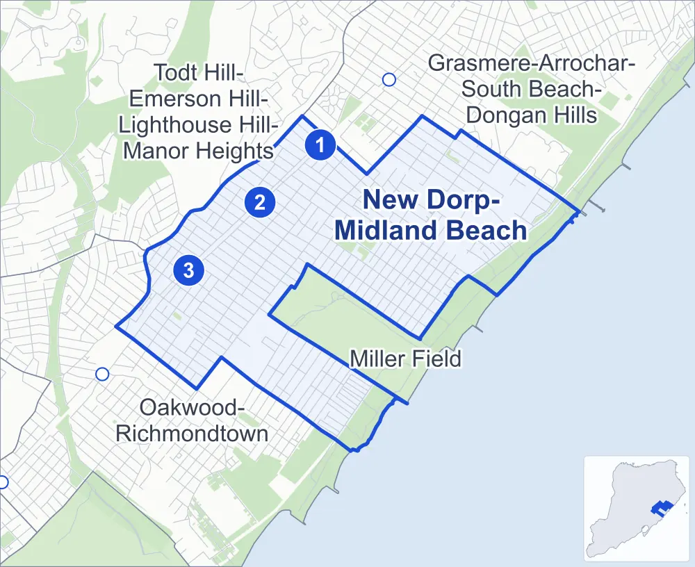
- New Dorp-Midland Beach
- A neighboring area
- Park
- A station in the list
- Another station
Neighborhood areas and streets: NYC Department of City Planning. Parks: NYC Parks. Stations: MTA.
Neighboring areas
- Grasmere-Arrochar-South Beach-Dongan Hills northeast
- Miller Field southeast
- Oakwood-Richmondtown southwest
- Todt Hill-Emerson Hill-Lighthouse Hill-Manor Heights northwest
Staten Island Railway stations
- Jefferson Av lines SIR
- Grant City lines SIR
- New Dorp lines SIR accessible
Getting around
The Staten Island Railway stops at Grant City, Jefferson Av and New Dorp, and buses on 19 routes stop in or at the edge of New Dorp-Midland Beach.
- 3 Staten Island Railway stations
- 1 of them listed by the MTA as fully accessible
- 10 local bus routes
- 9 express bus routes
Local bus routes
- S51
- S52
- S57
- S74
- S76
- S78
- S79-SBS
- S81
- S84
- S86
Express bus routes
- SIM1
- SIM1C
- SIM5
- SIM6
- SIM7
- SIM9
- SIM10
- SIM11
- SIM15
Safety record
Between 2021 and 2025, its corners averaged more police-reported crashes than the average Staten Island corner.
- 1,339 police-reported crashes at its corners
- 3.2 a corner, on average
- 2.2 the average Staten Island corner
- 162 corners with a clean record
Signal or safety changes on City record, at 36 of its corners
- Accessible pedestrian signals
- 35
- Leading pedestrian intervals
- 16
- Turn calming
- 4
Camera tickets
In 2025 its corners had more school-zone speed camera tickets than red-light or bus-lane tickets.
- 10,082 red-light camera tickets at four corners
- 15,114 school-zone speed camera tickets at 13 corners
- 1,461 bus-lane camera tickets at two corners
- Most red-light tickets
- Richmond Road & New Dorp Lane, 7,337
- Most speed tickets
- South Railroad Avenue & Princeton Avenue, 6,013
- Most bus-lane tickets
- Hylan Boulevard & Jefferson Avenue, 1,009
People and homes
The 2020 Census counted 29,083 residents in New Dorp-Midland Beach, about 13,000 per square mile.
- 10,822 homes, 2020 Census
- 347 homes added since April 2010, net, by City Planning's count
Half of its 7,780 residential lots hold buildings from 1965 or earlier, and 24% of them date from before 1940, by the City's tax lot records.
Parks
- Parkland
- 105.2 acres of NYC Parks property
- The largest pieces
- Franklin D. Roosevelt Boardwalk and Beach (54.7 acres), Great Kills Park (33.7 acres) and Midland Field (7.5 acres)
Streets and trees
- Trees
- 8,598 in NYC Parks' records, most often London planetree, Callery pear and pin oak
- Street with the most corners
- Lincoln Avenue, with 25 of the area's 414
- Height above sea level
- From 1 foot at Patterson Avenue & Graham Boulevard to 66 feet at Richmond Road & Otis Avenue
- Honorary street names
- 37 at its corners, enacted by local law
Schools and libraries
The City lists eight schools and one library in New Dorp-Midland Beach.
- Public schools
- 5
- Charter and private schools
- 3
- Library
- New Dorp Library
Public safety
How complaints are countedIn 2025 the NYPD recorded 203 major felonies at places in New Dorp-Midland Beach.
Recorded by the NYPD at places in New Dorp-Midland Beach
- 196 major felonies in 2024
- 974 other felonies, misdemeanors and violations in 2025
In 2025, on the streets along the edge of New Dorp-Midland Beach, the NYPD recorded another 39 major felonies.
- Police precinct
- 122nd
From January to June 2026 the NYPD recorded 80 major felonies at places in New Dorp-Midland Beach, against 111 in the same months of 2025.
Sources: the NYPD's Complaint Data Historic, updated April 28, 2026, and Complaint Data Current (Year To Date), updated July 27, 2026, on NYC Open Data. Figures to June 30, 2026.
Street corners
- 3rd Street & Beach Avenue
- 3rd Street & Burbank Avenue
- 3rd Street & Cloister Place
- 3rd Street & Locust Avenue
- 3rd Street & Rose Avenue
- 3rd Street & Ross Avenue
- 3rd Street & Steele Avenue
- 7th Street & Allison Avenue
- 8th Street & Allison Avenue
- 8th Street & Beach Avenue
- 8th Street & Cannon Boulevard
- 8th Street & Princeton Avenue
- 8th Street & Reno Avenue
- 8th Street & Ross Avenue
- 10th Street & Allison Avenue
- 10th Street & Beach Avenue
- 10th Street & Cannon Boulevard
- 10th Street & Coddington Avenue
- 10th Street & Lindbergh Avenue
- 10th Street & Princeton Avenue
- 10th Street & Reno Avenue
- 10th Street & Ross Avenue
- 10th Street & Sterling Avenue
- Adams Avenue & Boundary Avenue
- Adams Avenue & Bowden Street
- Adams Avenue & Cascade Street
- Adams Avenue & Haven Avenue
- Adams Avenue & Husson Street
- Adams Avenue & Idlease Place
- Allison Avenue & Colgate Place
- Amboy Road & 1st Street
- Amboy Road & 3rd Street
- Amboy Road & Arc Place
- Amboy Road & Belfast Avenue
- Amboy Road & Dale Avenue
- Baden Place & Graham Boulevard
- Baden Place & Hempstead Avenue
- Baden Place & Mapleton Avenue
- Bancroft Avenue & Kruser Street
- Beach Avenue & 7th Street
- Beach Avenue & 9th Street
- Beach Avenue & Behan Court
- Beach Avenue & New Dorp Plaza
- Beachview Avenue & Idlease Place
- Bedford Avenue & Boundary Avenue
- Bedford Avenue & Edison Street
- Bedford Avenue & Grimsby Street
- Bedford Avenue & Husson Street
- Bedford Avenue & Juniper Place
- Bedford Avenue & Kiswick Street
- Bedford Avenue & Laconia Avenue
- Bedford Avenue & Lisbon Place
- Bedford Avenue & Moreland Street
- Bedford Avenue & Nugent Avenue
- Boundary Avenue & Beachview Avenue
- Boundary Avenue & Hull Avenue
- Boundary Avenue & Maplewood Place
- Boundary Avenue & Zwicky Avenue
- Bryant Avenue & Allison Place
- Bryant Avenue & Kruser Street
- Buel Avenue & Laconia Avenue
- Buel Avenue & Mason Avenue
- Buel Avenue & Nugent Avenue
- Buel Avenue & Oceanside Avenue
- Buel Avenue & Quincy Avenue
- Cannon Boulevard & Colgate Place
- Cedar Grove Avenue & Cedar Grove Court
- Cedar Grove Avenue & Center Place
- Cedar Grove Avenue & Garibaldi Avenue
- Cedar Grove Avenue & Maple Terrace
- Cedar Grove Avenue & Marine Way
- Cedar Grove Avenue & Milbank Road
- Cedar Grove Avenue & Neptune Street
- Cedar Grove Avenue & Neutral Avenue
- Cedar Grove Avenue & Seafoam Street
- Cedar Grove Avenue & Topping Street
- Cedar Grove Avenue & Waterside Street
- Cedar Grove Avenue & Wavecrest Street
- Clawson Street & Allison Avenue
- Clawson Street & Bache Avenue
- Clawson Street & Bancroft Avenue
- Clawson Street & Beach Avenue
- Clawson Street & Bryant Avenue
- Clawson Street & Burbank Avenue
- Clawson Street & Cannon Boulevard
- Clawson Street & Coddington Avenue
- Clawson Street & Colfax Avenue
- Clawson Street & Fremont Avenue
- Clawson Street & Greeley Avenue
- Clawson Street & Jacques Avenue
- Clawson Street & Lincoln Avenue
- Clawson Street & Lindbergh Avenue
- Clawson Street & Locust Avenue
- Clawson Street & Midland Avenue
- Clawson Street & New Dorp Lane
- Clawson Street & Otis Avenue
- Clawson Street & Prescott Avenue
- Clawson Street & Princeton Avenue
- Clawson Street & Reno Avenue
- Clawson Street & Rose Avenue
- Clawson Street & Ross Avenue
- Clawson Street & Sterling Avenue
- Colfax Avenue & Lisbon Place
- Colony Avenue & Graham Boulevard
- Colony Avenue & Hempstead Avenue
- Colony Avenue & Mapleton Avenue
- Cuba Avenue & Celtic Place
- Cuba Avenue & Clayboard Street
- Cuba Avenue & Ina Street
- Dongan Hills Avenue & Nugent Avenue
- Dustan Street & Beacon Place
- Dustan Street & Center Place
- Dustan Street & Maple Terrace
- Dustan Street & Neptune Street
- Dustan Street & Seafoam Street
- Dustan Street & Waterside Street
- Ebbitts Street & Cuba Avenue
- Ebbitts Street & Titus Avenue
- Ebbitts Street & Winham Avenue
- Edison Street & Bache Avenue
- Edison Street & Bancroft Avenue
- Edison Street & Bryant Avenue
- Edison Street & Burbank Avenue
- Edison Street & Colfax Avenue
- Edison Street & Fremont Avenue
- Edison Street & Jacques Avenue
- Edison Street & Locust Avenue
- Edison Street & Otis Avenue
- Edison Street & Prescott Avenue
- Father Capodanno Boulevard & Buel Avenue
- Father Capodanno Boulevard & Graham Boulevard
- Father Capodanno Boulevard & Hunter Avenue
- Father Capodanno Boulevard & Iona Street
- Father Capodanno Boulevard & Jefferson Avenue
- Father Capodanno Boulevard & Lincoln Avenue
- Father Capodanno Boulevard & Midland Avenue
- Father Capodanno Boulevard & Naughton Avenue
- Father Capodanno Boulevard & Peggy Lane
- Father Capodanno Boulevard & Slater Boulevard
- Finley Avenue & Beacon Place
- Finley Avenue & Marine Way
- Francine Court & Arc Place
- Francine Court & Behan Court
- Freeborn Street & Graham Boulevard
- Freeborn Street & Hempstead Avenue
- Freeborn Street & Mapleton Avenue
- Fremont Avenue & Kruser Street
- Greeley Avenue & Baden Place
- Greeley Avenue & Boundary Avenue
- Greeley Avenue & Colony Avenue
- Greeley Avenue & Edison Street
- Greeley Avenue & Freeborn Street
- Greeley Avenue & Grant Place
- Greeley Avenue & Grimsby Street
- Greeley Avenue & Kiswick Street
- Greeley Avenue & Kruser Street
- Greeley Avenue & Moreland Street
- Greeley Avenue & Nugent Avenue
- Greeley Avenue & Oldfield Street
- Greeley Avenue & Patterson Avenue
- Greeley Avenue & Poultney Street
- Greeley Avenue & Rudyard Street
- Greeley Avenue & Sanilac Street
- Grimsby Street & Graham Boulevard
- Grimsby Street & Mapleton Avenue
- Hamden Avenue & Boundary Avenue
- Hamden Avenue & Husson Street
- Hamden Avenue & Idlease Place
- Hamden Avenue & Juniper Place
- Hett Avenue & Beacon Place
- Hett Avenue & Marine Way
- Hunter Avenue & Baden Place
- Hunter Avenue & Boundary Avenue
- Hunter Avenue & Bowden Street
- Hunter Avenue & Cascade Street
- Hunter Avenue & Colony Avenue
- Hunter Avenue & Freeborn Street
- Hunter Avenue & Grimsby Street
- Hunter Avenue & Haven Avenue
- Hunter Avenue & Husson Street
- Hunter Avenue & Idlease Place
- Hunter Avenue & Juniper Place
- Hunter Avenue & Kiswick Street
- Hunter Avenue & Moreland Street
- Hunter Avenue & Nugent Avenue
- Hunter Avenue & Patterson Avenue
- Husson Street & Hull Avenue
- Hylan Boulevard & Adams Avenue
- Hylan Boulevard & Allison Avenue
- Hylan Boulevard & Beach Avenue
- Hylan Boulevard & Bedford Avenue
- Hylan Boulevard & Bryant Avenue
- Hylan Boulevard & Burbank Avenue
- Hylan Boulevard & Dongan Hills Avenue
- Hylan Boulevard & Hamden Avenue
- Hylan Boulevard & Hull Avenue
- Hylan Boulevard & Hunter Avenue
- Hylan Boulevard & Jacques Avenue
- Hylan Boulevard & Jefferson Avenue
- Hylan Boulevard & Lincoln Avenue
- Hylan Boulevard & Locust Avenue
- Hylan Boulevard & Midland Avenue
- Hylan Boulevard & Naughton Avenue
- Hylan Boulevard & New Dorp Lane
- Hylan Boulevard & Otis Avenue
- Hylan Boulevard & Ross Avenue
- Hylan Boulevard & Slater Boulevard
- Hylan Boulevard & Tysens Lane
- Hylan Boulevard & Zwicky Avenue
- Jefferson Avenue & Boundary Avenue
- Jefferson Avenue & Haven Avenue
- Jefferson Avenue & Meadow Place
- Jefferson Avenue & Patterson Avenue
- Laconia Avenue & Adams Avenue
- Laconia Avenue & Hamden Avenue
- Laconia Avenue & Jefferson Avenue
- Laconia Avenue & Liberty Avenue
- Laconia Avenue & Naughton Avenue
- Laconia Avenue & Rowan Avenue
- Laconia Avenue & Seaver Avenue
- Laconia Avenue & Slater Boulevard
- Laconia Avenue & Stobe Avenue
- Liberty Avenue & Oceanside Avenue
- Liberty Avenue & Patterson Avenue
- Liberty Avenue & Quincy Avenue
- Lincoln Avenue & Baden Place
- Lincoln Avenue & Boundary Avenue
- Lincoln Avenue & Colony Avenue
- Lincoln Avenue & Edison Street
- Lincoln Avenue & Freeborn Street
- Lincoln Avenue & Grant Place
- Lincoln Avenue & Grimsby Street
- Lincoln Avenue & Hylan Place
- Lincoln Avenue & Kiswick Street
- Lincoln Avenue & Lisbon Place
- Lincoln Avenue & Mason Avenue
- Lincoln Avenue & Moreland Street
- Lincoln Avenue & Nugent Avenue
- Lincoln Avenue & Oldfield Street
- Lincoln Avenue & Patterson Avenue
- Lincoln Avenue & Poultney Street
- Lincoln Avenue & Rudyard Street
- Lincoln Avenue & Sanilac Street
- Mason Avenue & Adams Avenue
- Mason Avenue & Bedford Avenue
- Mason Avenue & Dongan Hills Avenue
- Mason Avenue & Greeley Avenue
- Mason Avenue & Hamden Avenue
- Mason Avenue & Jefferson Avenue
- Mason Avenue & Liberty Avenue
- Mason Avenue & Naughton Avenue
- Mason Avenue & Seaver Avenue
- Mason Avenue & Slater Boulevard
- Mason Avenue & Stobe Avenue
- Midland Avenue & Baden Place
- Midland Avenue & Boundary Avenue
- Midland Avenue & Colony Avenue
- Midland Avenue & Edison Street
- Midland Avenue & Freeborn Street
- Midland Avenue & Grant Place
- Midland Avenue & Grimsby Street
- Midland Avenue & Husson Street
- Midland Avenue & Kiswick Street
- Midland Avenue & Lisbon Place
- Midland Avenue & Mason Avenue
- Midland Avenue & Moreland Street
- Midland Avenue & Nugent Avenue
- Midland Avenue & Olympia Boulevard
- Midland Avenue & Patterson Avenue
- Midland Avenue & Stacey Lane
- Mill Road & Dartmouth Loop
- Mill Road & Ina Street
- Mill Road & Windmill Court
- Milton Avenue & Beacon Place
- Milton Avenue & Ebbitts Street
- Milton Avenue & Marine Way
- Naughton Avenue & Oceanside Avenue
- Naughton Avenue & Quincy Avenue
- New Dorp Lane & 2nd Street
- New Dorp Lane & 3rd Street
- New Dorp Lane & 4th Street
- New Dorp Lane & 8th Street
- New Dorp Lane & 9th Street
- New Dorp Lane & 10th Street
- New Dorp Lane & Cuba Avenue
- New Dorp Lane & Edison Street
- New Dorp Lane & Finley Avenue
- New Dorp Lane & Hett Avenue
- New Dorp Lane & Milton Avenue
- New Dorp Lane & New Dorp Plaza
- New Dorp Lane & Roma Avenue
- New Dorp Lane & Shore Road
- New Dorp Lane & Titus Avenue
- New Dorp Lane & Weed Avenue
- New Dorp Lane & Winham Avenue
- New Dorp Plaza & Ross Avenue
- North Railroad Avenue & Adams Avenue
- North Railroad Avenue & Bancroft Avenue
- North Railroad Avenue & Barton Avenue
- North Railroad Avenue & Bedford Avenue
- North Railroad Avenue & Bryant Avenue
- North Railroad Avenue & Burbank Avenue
- North Railroad Avenue & Colfax Avenue
- North Railroad Avenue & Fremont Avenue
- North Railroad Avenue & Greeley Avenue
- North Railroad Avenue & Hamden Avenue
- North Railroad Avenue & Hull Avenue
- North Railroad Avenue & Hunter Avenue
- North Railroad Avenue & Lincoln Avenue
- North Railroad Avenue & Locust Avenue
- North Railroad Avenue & Midland Avenue
- North Railroad Avenue & New Dorp Plaza
- North Railroad Avenue & Otis Avenue
- North Railroad Avenue & Prescott Avenue
- North Railroad Avenue & Steele Avenue
- Nugent Avenue & Adams Avenue
- Nugent Avenue & Jefferson Avenue
- Nugent Avenue & Liberty Avenue
- Nugent Avenue & Naughton Avenue
- Nugent Avenue & Slater Boulevard
- Olympia Boulevard & Dongan Hills Avenue
- Olympia Boulevard & Graham Boulevard
- Olympia Boulevard & Greeley Avenue
- Olympia Boulevard & Hempstead Avenue
- Olympia Boulevard & Hunter Avenue
- Olympia Boulevard & Liberty Avenue
- Olympia Boulevard & Lincoln Avenue
- Olympia Boulevard & Mapleton Avenue
- Olympia Boulevard & Naughton Avenue
- Olympia Boulevard & Slater Boulevard
- Olympia Boulevard & Wahler Place
- Otis Avenue & Allison Place
- Otis Avenue & Kruser Street
- Patterson Avenue & Graham Boulevard
- Patterson Avenue & Hempstead Avenue
- Patterson Avenue & Jason Court
- Patterson Avenue & Mapleton Avenue
- Patterson Avenue & Peggy Lane
- Prescott Avenue & Kruser Street
- Princeton Avenue & Colgate Place
- Quincy Avenue & Cherokee Street
- Quincy Avenue & Graham Boulevard
- Quincy Avenue & Iona Street
- Quincy Avenue & Sioux Street
- Reno Avenue & Ella Place
- Reno Avenue & Isora Place
- Reno Avenue & Thomas Place
- Richmond Road & Colfax Avenue
- Richmond Road & Fremont Avenue
- Richmond Road & Hunter Avenue
- Richmond Road & Lincoln Avenue
- Richmond Road & New Dorp Lane
- Richmond Road & Otis Avenue
- Richmond Road & Prescott Avenue
- Richmond Road & Steele Avenue
- Richmond Road & Todt Hill Road
- Roma Avenue & Beacon Place
- Roma Avenue & Garibaldi Avenue
- Roma Avenue & Marine Way
- Rose Avenue & 1st Street
- Rose Avenue & 2nd Street
- Rose Avenue & 4th Street
- Rose Avenue & 8th Street
- Rose Avenue & 9th Street
- Rose Avenue & 10th Street
- Rose Avenue & New Dorp Plaza
- Ross Avenue & 1st Street
- Ross Avenue & 2nd Street
- Ross Avenue & 4th Street
- Ross Avenue & 7th Street
- Ross Avenue & 9th Street
- Sanchez Drive & New Dorp Lane
- Seaver Avenue & Quincy Avenue
- Seaview Avenue & Nugent Avenue
- Seaview Avenue & Oceanside Avenue
- Seaview Avenue & Quincy Avenue
- Seaview Avenue & S Beach Behavioral Health Center Driveway
- Slater Boulevard & Quincy Avenue
- Smiths Lane & Ebbitts Street
- South Railroad Avenue & Adams Avenue
- South Railroad Avenue & Allison Avenue
- South Railroad Avenue & Bache Avenue
- South Railroad Avenue & Bancroft Avenue
- South Railroad Avenue & Beach Avenue
- South Railroad Avenue & Bedford Avenue
- South Railroad Avenue & Bryant Avenue
- South Railroad Avenue & Burbank Avenue
- South Railroad Avenue & Cannon Boulevard
- South Railroad Avenue & Colfax Avenue
- South Railroad Avenue & Fremont Avenue
- South Railroad Avenue & Greeley Avenue
- South Railroad Avenue & Hamden Avenue
- South Railroad Avenue & Hull Avenue
- South Railroad Avenue & Hunter Avenue
- South Railroad Avenue & Lincoln Avenue
- South Railroad Avenue & Locust Avenue
- South Railroad Avenue & Midland Avenue
- South Railroad Avenue & New Dorp Plaza
- South Railroad Avenue & Otis Avenue
- South Railroad Avenue & Prescott Avenue
- South Railroad Avenue & Princeton Avenue
- South Railroad Avenue & Reno Avenue
- Stobe Avenue & Meadow Place
- Titus Avenue & Ina Street
- Tysens Lane & 8th Street
- Tysens Lane & Ella Place
- Tysens Lane & Isora Place
- Tysens Lane & Thomas Place
- Wavecrest Street & Dustan Street
- Weed Avenue & Celtic Place
- Weed Avenue & Clayboard Street
- Winham Avenue & Celtic Place
- Winham Avenue & Clayboard Street
- Zwicky Avenue & Stacey Lane
How the figures above are measured: Methodology.