Oakwood-Richmondtown
Neighborhood · Staten Island
Oakwood-Richmondtown reaches from Richmondtown, near the geographic center of Staten Island, east through Oakwood to Oakwood Beach on Lower New York Bay.
- 2.01 square miles
- 22,388 residents, 2020 Census
- 370 street corners
- 2 Staten Island Railway stations
- 17 bus routes
Richmondtown, first known as Coccles Town for the shells in nearby waters, took its present name in 1728 and long served as the seat of Richmond County. Its historic core is preserved as Historic Richmond Town, a living history village and museum begun in 1958 by the Staten Island Historical Society and the City, with more than 30 buildings and sites. Oakwood, where farms once covered the higher ground and a resort lined the shore, was largely built up after the Verrazzano-Narrows Bridge opened in 1964.
Sources: Historic Richmond Town; Historic Richmond Town (Wikipedia); Richmondtown, Staten Island (Wikipedia); Oakwood, Staten Island (Wikipedia).
Oakwood-Richmondtown borders four areas, and Amboy Road holds more of its corners than any other street, 28 of 370.
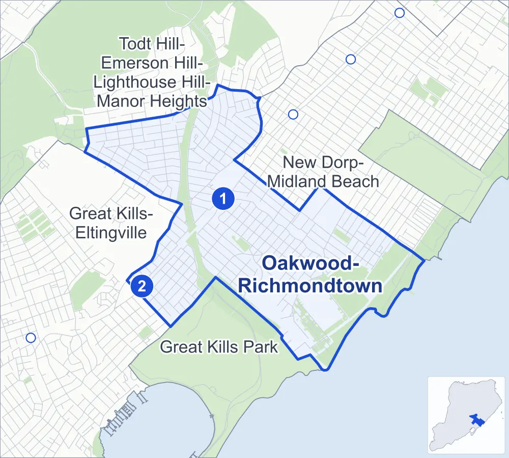
- Oakwood-Richmondtown
- A neighboring area
- Park
- A station in the list
- Another station
Neighborhood areas and streets: NYC Department of City Planning. Parks: NYC Parks. Stations: MTA.
Neighboring areas
- New Dorp-Midland Beach northeast
- Great Kills Park south
- Great Kills-Eltingville west
- Todt Hill-Emerson Hill-Lighthouse Hill-Manor Heights northwest
Staten Island Railway stations
- Oakwood Heights lines SIR
- Bay Terrace lines SIR
Getting around
The Staten Island Railway stops at Bay Terrace and Oakwood Heights, and buses on 17 routes stop in or at the edge of Oakwood-Richmondtown.
- 2 Staten Island Railway stations
- 8 local bus routes
- 9 express bus routes
Local bus routes
- S54
- S57
- S74
- S76
- S78
- S79-SBS
- S84
- S86
Express bus routes
- SIM1
- SIM1C
- SIM5
- SIM6
- SIM7
- SIM9
- SIM10
- SIM11
- SIM15
Safety record
Between 2021 and 2025, its corners averaged fewer police-reported crashes than the average Staten Island corner.
- 502 police-reported crashes at its corners
- 1.4 a corner, on average
- 2.2 the average Staten Island corner
- 202 corners with a clean record
Signal or safety changes on City record, at 21 of its corners
- Accessible pedestrian signals
- 20
- Leading pedestrian intervals
- 6
- Safety Improvement Projects
- 2
- Turn calming
- 1
Camera tickets
In 2025 its corners had more school-zone speed camera tickets than red-light or bus-lane tickets.
- 0 red-light camera tickets
- 8,427 school-zone speed camera tickets at ten corners
- 0 bus-lane camera tickets
- Most speed tickets
- Hylan Boulevard & Guyon Avenue, 2,334
People and homes
The 2020 Census counted 22,388 residents in Oakwood-Richmondtown, about 11,100 per square mile.
- 8,568 homes, 2020 Census
- 57 homes added since April 2010, net, by City Planning's count
Half of its 5,818 residential lots hold buildings from 1965 or earlier, and 7% of them date from before 1940, by the City's tax lot records.
Parks and landmarks
- Parkland
- 157.2 acres of Great Kills Park, as NYC Parks maps it within Oakwood-Richmondtown
- Designated landmark
- Saint Patrick's Church
Streets and trees
- Trees
- 5,690 in NYC Parks' records, most often London planetree, Callery pear and pin oak
- Street with the most corners
- Amboy Road, with 28 of the area's 370
- Height above sea level
- From 3 feet at Cedar Grove Avenue & Tarlton Street to 88 feet at Amboy Road & Benton Court
- Honorary street names
- 14 at its corners, enacted by local law
Schools
The City lists five schools in Oakwood-Richmondtown.
- Public schools
- 2
- Charter and private schools
- 3
Public art
The City's public art inventory lists one work in Oakwood-Richmondtown: Egbertville World War Memorial (1920).
- 1 work of public art
Public safety
How complaints are countedIn 2025 the NYPD recorded 83 major felonies at places in Oakwood-Richmondtown.
Recorded by the NYPD at places in Oakwood-Richmondtown
- 88 major felonies in 2024
- 365 other felonies, misdemeanors and violations in 2025
In 2025, on the streets along the edge of Oakwood-Richmondtown, the NYPD recorded another 20 major felonies. Counting the streets along its edge, in 2025 the NYPD recorded 4.6 major felonies for every thousand residents the 2020 Census counted in Oakwood-Richmondtown.
- Police precinct
- 122nd
From January to June 2026 the NYPD recorded 32 major felonies at places in Oakwood-Richmondtown, against 44 in the same months of 2025.
Sources: the NYPD's Complaint Data Historic, updated April 28, 2026, and Complaint Data Current (Year To Date), updated July 27, 2026, on NYC Open Data. Figures to June 30, 2026.
Street corners
- 8th Street & Clarence Place
- 8th Street & Peter Avenue
- 10th Street & Peter Avenue
- Adelaide Avenue & Amherst Avenue
- Adelaide Avenue & Elmira Street
- Adelaide Avenue & Falcon Avenue
- Adelaide Avenue & Flint Street
- Adelaide Avenue & Lynn Street
- Adelaide Avenue & Pendale Street
- Adelaide Avenue & Platt Street
- Adelaide Avenue & Riga Street
- Adelaide Avenue & Tarring Street
- Adelaide Avenue & Whitehall Street
- Amber Street & Andrews Avenue
- Amber Street & Combs Avenue
- Amber Street & Shadow Lane
- Amber Street & West Cedarview Avenue
- Amber Street & Wilder Avenue
- Amboy Road & 2nd Street
- Amboy Road & Amber Street
- Amboy Road & Beach Avenue
- Amboy Road & Behan Court
- Amboy Road & Benton Court
- Amboy Road & Bishop Street
- Amboy Road & Buffalo Street
- Amboy Road & Cedarview Avenue
- Amboy Road & Clarke Avenue
- Amboy Road & East Broadway
- Amboy Road & Emmet Avenue
- Amboy Road & Erwin Court
- Amboy Road & Farrell Court
- Amboy Road & Gail Court
- Amboy Road & Guyon Avenue
- Amboy Road & Hopkins Avenue
- Amboy Road & Junction Court
- Amboy Road & Mobile Avenue
- Amboy Road & Oakley Place
- Amboy Road & Park Street
- Amboy Road & Prospect Place
- Amboy Road & Richmond Road
- Amboy Road & Riedel Avenue
- Amboy Road & Spratt Avenue
- Amboy Road & Thomas Street
- Amboy Road & Tysens Lane
- Amboy Road & Vincent Avenue
- Amboy Road & Wolverine Street
- Ardsley Street & Andrews Avenue
- Ardsley Street & Gilbert Street
- Ardsley Street & Kensico Street
- Ardsley Street & Maplewood Avenue
- Ardsley Street & McKinley Avenue
- Ardsley Street & Moore Street
- Ardsley Street & Riedel Avenue
- Ardsley Street & Wilder Avenue
- Aviston Street & Amherst Avenue
- Aviston Street & Brook Avenue
- Aviston Street & Lynn Street
- Aviston Street & Medina Street
- Aviston Street & Tarrytown Avenue
- Barbara Street & Andrews Avenue
- Barbara Street & Combs Avenue
- Barbara Street & East Broadway
- Barbara Street & Kensico Street
- Barbara Street & McKinley Avenue
- Barbara Street & Wilder Avenue
- Beach Avenue & Prospect Place
- Belfast Avenue & Coverly Street
- Belfast Avenue & Ebony Street
- Bishop Street & Cranford Avenue
- Bishop Street & Dalton Avenue
- Bishop Street & Ebony Street
- Brook Avenue & Ithaca Street
- Brown Boulevard & Smiths Lane
- Buffalo Street & Durant Avenue
- Buffalo Street & Emmet Avenue
- Buffalo Street & Hooper Avenue
- Buffalo Street & O'Gorman Avenue
- Buffalo Street & Sheridan Court
- Buffalo Street & Twombly Avenue
- Cedar Grove Avenue & Fox Beach Avenue
- Cedar Grove Avenue & Fox Lane
- Cedar Grove Avenue & Tarlton Street
- Center Street & Andrews Avenue
- Center Street & Kensico Street
- Center Street & McKinley Avenue
- Center Street & Moore Street
- Center Street & St Patricks Place
- Center Street & Wilder Avenue
- Champlain Avenue & Peel Place
- Champlain Avenue & Platt Street
- Chesterton Avenue & Grayson Street
- Chesterton Avenue & Pendale Street
- Chesterton Avenue & Platt Street
- Clarke Avenue & Amber Street
- Clarke Avenue & Combs Avenue
- Clarke Avenue & Dylan Way
- Clarke Avenue & Gilbert Street
- Clarke Avenue & Montreal Avenue
- Clarke Avenue & Savoy Street
- Clarke Avenue & Wolverine Street
- Clawson Street & Adelaide Avenue
- Clawson Street & Guyon Avenue
- Clawson Street & Isabella Avenue
- Clawson Street & Oak Avenue
- Clawson Street & Penn Avenue
- Clawson Street & Peter Avenue
- Clawson Street & Tysens Lane
- Combs Avenue & Altoona Avenue
- Cranford Avenue & Cranford Court
- Cranford Avenue & East Broadway
- Cranford Avenue & Hitchcock Avenue
- Cranford Avenue & Joel Place
- Cuba Avenue & Isernia Avenue
- Dalton Avenue & Belfast Avenue
- Dalton Avenue & Mobile Avenue
- Dalton Avenue & Morley Avenue
- Dalton Avenue & Vincent Avenue
- Dorothea Place & Dale Avenue
- Dorothea Place & Grace Road
- Dorothea Place & Ilion Place
- Dorothea Place & Oakley Place
- Dugdale Street & Merkel Place
- Durant Avenue & Bay Terrace
- Durant Avenue & Hopkins Avenue
- Durant Avenue & Justin Avenue
- Durant Avenue & Kelvin Avenue
- Durant Avenue & Spratt Avenue
- East Broadway & Shadow Lane
- Ebbitts Street & Finley Avenue
- Ebbitts Street & Hett Avenue
- Ebbitts Street & Manila Place
- Ebbitts Street & Roma Avenue
- Ebbitts Street & Weed Avenue
- Ebony Street & Ilion Place
- Ebony Street & Morley Avenue
- Emmet Avenue & Hooper Avenue
- Emmet Avenue & Sheridan Court
- Emmet Avenue & Twombly Avenue
- Fairbanks Avenue & Grayson Street
- Fairbanks Avenue & Pendale Street
- Fairbanks Avenue & Platt Street
- Falcon Avenue & Malden Place
- Finley Avenue & Finley Road
- Finley Avenue & Navesink Place
- Grace Road & Holly Place
- Guyon Avenue & Acorn Street
- Guyon Avenue & Amherst Avenue
- Guyon Avenue & Elmira Street
- Guyon Avenue & Falcon Avenue
- Guyon Avenue & Flint Street
- Guyon Avenue & Leeds Street
- Guyon Avenue & Lynn Street
- Guyon Avenue & Medina Street
- Guyon Avenue & Pendale Street
- Guyon Avenue & Riga Street
- Guyon Avenue & Stoneham Street
- Guyon Avenue & Tarring Street
- Guyon Avenue & Tarrytown Avenue
- Guyon Avenue & Whitehall Street
- Hett Avenue & Fox Beach Avenue
- Hett Avenue & Fox Lane
- Hett Avenue & Jennifer Lane
- Hett Avenue & Michelle Lane
- Hett Avenue & Navesink Place
- Hopkins Avenue & Block Street
- Hopkins Avenue & Hooper Avenue
- Hopkins Avenue & Sheridan Court
- Hopkins Avenue & Thollen Street
- Hopkins Avenue & Twombly Avenue
- Hylan Boulevard & Buffalo Street
- Hylan Boulevard & Chesterton Avenue
- Hylan Boulevard & Guyon Avenue
- Hylan Boulevard & Hopkins Avenue
- Hylan Boulevard & Justin Avenue
- Hylan Boulevard & Malden Place
- Hylan Boulevard & Pendale Street
- Hylan Boulevard & Peter Avenue
- Isabella Avenue & Amherst Avenue
- Isabella Avenue & Elmira Street
- Isabella Avenue & Falcon Avenue
- Isabella Avenue & Flint Street
- Isabella Avenue & Leeds Street
- Isabella Avenue & Lynn Street
- Isabella Avenue & Medina Street
- Isabella Avenue & Old Mill Road
- Isabella Avenue & Pendale Street
- Isabella Avenue & Riga Street
- Isabella Avenue & Stoneham Street
- Isabella Avenue & Tarring Street
- Isabella Avenue & Tarrytown Avenue
- Isabella Avenue & Whitehall Street
- Isernia Avenue & Manila Avenue
- Justin Avenue & Hooper Avenue
- Justin Avenue & Thollen Street
- Justin Avenue & Twombly Avenue
- Malden Place & Primrose Place
- Malone Avenue & Grayson Street
- Malone Avenue & Platt Street
- Manila Avenue & Eva Avenue
- Manila Avenue & Roberts Drive
- Manila Place & Diaz Place
- Michelle Lane & Jennifer Lane
- Mill Road & Adelaide Avenue
- Mill Road & Aviston Street
- Mill Road & Barry Court
- Mill Road & Delwit Avenue
- Mill Road & Ebbitts Street
- Mill Road & Fox Beach Avenue
- Mill Road & Fox Lane
- Mill Road & Guyon Avenue
- Mill Road & Isernia Avenue
- Mill Road & Oak Avenue
- Mill Road & Old Mill Road
- Mill Road & Penn Avenue
- Mill Road & Peter Avenue
- Mill Road & Roberts Drive
- Mill Road & Tarlton Street
- Milton Avenue & Finley Road
- Milton Avenue & Isernia Avenue
- Milton Avenue & Navesink Place
- Mobile Avenue & Coverly Street
- Montreal Avenue & General Street
- Montreal Avenue & Grayson Street
- Montreal Avenue & Pendale Street
- Montreal Avenue & Platt Street
- Natick Street & Andrews Avenue
- Natick Street & Connor Avenue
- Natick Street & Kensico Street
- Natick Street & Maplewood Avenue
- Natick Street & McKinley Avenue
- North Railroad Avenue & Benton Court
- North Railroad Avenue & Buffalo Street
- North Railroad Avenue & Cedarview Avenue
- North Railroad Avenue & Chesterton Avenue
- North Railroad Avenue & Emmet Avenue
- North Railroad Avenue & Fairbanks Avenue
- North Railroad Avenue & Guyon Avenue
- North Railroad Avenue & Hopkins Avenue
- North Railroad Avenue & Justin Avenue
- North Railroad Avenue & Montreal Avenue
- North Railroad Avenue & Riedel Avenue
- North Railroad Avenue & Spratt Avenue
- North Railroad Avenue & Windemere Avenue
- O'Gorman Avenue & Emmet Avenue
- O'Gorman Avenue & Hopkins Avenue
- O'Gorman Avenue & Justin Avenue
- O'Gorman Avenue & Kelvin Avenue
- O'Gorman Avenue & Spratt Avenue
- Oak Avenue & Acorn Street
- Oak Avenue & Amherst Avenue
- Oak Avenue & Elmira Street
- Oak Avenue & Falcon Avenue
- Oak Avenue & Flint Street
- Oak Avenue & Leeds Street
- Oak Avenue & Lynn Street
- Oak Avenue & Medina Street
- Oak Avenue & Pendale Street
- Oak Avenue & Riga Street
- Oak Avenue & Tarrytown Avenue
- Oak Avenue & Whitehall Street
- Oakley Place & Cubberly Place
- Oakley Place & Holly Place
- Old Mill Road & Kissam Avenue
- Old Mill Road & Pelican Circle
- Park Street & Andrews Avenue
- Park Street & Combs Avenue
- Park Street & Cranford Avenue
- Park Street & Dalton Avenue
- Park Street & East Broadway
- Park Street & Kensico Street
- Park Street & Pinewood Avenue
- Park Street & Shadow Lane
- Park Street & Wilder Avenue
- Park Street & Wiley Place
- Pendale Street & Malone Avenue
- Penn Avenue & 8th Street
- Penn Avenue & 10th Street
- Penn Avenue & Falcon Avenue
- Peter Avenue & Falcon Avenue
- Pinewood Avenue & Connor Avenue
- Pinewood Avenue & Maplewood Avenue
- Richmond Road & Andrews Avenue
- Richmond Road & Aultman Avenue
- Richmond Road & Cranford Avenue
- Richmond Road & Dorothea Place
- Richmond Road & Geldner Avenue
- Richmond Road & Kensico Street
- Richmond Road & Milburn Street
- Richmond Road & Morley Avenue at Enfield Place
- Richmond Road & Riedel Avenue
- Richmond Road & Santo Court
- Richmond Road & Summit Avenue
- Richmond Road & Tupelo Court
- Riedel Avenue & Amber Street
- Riedel Avenue & Barbara Street
- Riedel Avenue & Cedarview Avenue
- Riedel Avenue & Hitchcock Avenue
- Riedel Avenue & Joel Place
- Riedel Avenue & Park Street
- Riedel Avenue & Savoy Street
- Riedel Avenue & Thomas Street
- Riedel Avenue & Windemere Avenue
- Riedel Avenue & Wolverine Street
- Riga Street & Aviston Street
- Riga Street & Dugdale Street
- Roma Avenue & Jennifer Lane
- Roma Avenue & Navesink Place
- South Railroad Avenue & Bay Terrace
- South Railroad Avenue & Cedarview Avenue Footbridge
- South Railroad Avenue & Champlain Avenue
- South Railroad Avenue & Clarence Place
- South Railroad Avenue & Emmet Avenue
- South Railroad Avenue & Guyon Avenue
- South Railroad Avenue & Hopkins Avenue
- South Railroad Avenue & Justin Avenue
- South Railroad Avenue & Kelvin Avenue
- South Railroad Avenue & Malone Avenue
- South Railroad Avenue & Oak Avenue
- South Railroad Avenue & Penn Avenue
- South Railroad Avenue & Peter Avenue
- South Railroad Avenue & Spratt Avenue
- South Railroad Avenue & Tysens Lane
- Spratt Avenue & Block Street
- Spratt Avenue & Hooper Avenue
- Spratt Avenue & Sheridan Court
- Spratt Avenue & Thollen Street
- Spratt Avenue & Twombly Avenue
- Thollen Street & Ovis Place
- Thollen Street & Thayer Place
- Thomas Street & Amber Street
- Thomas Street & Combs Avenue
- Thomas Street & Gilbert Street
- Thomas Street & Kensico Street
- Thomas Street & McKinley Avenue
- Thomas Street & Natick Street
- Thomas Street & Wilder Avenue
- Thomas Street & Wolverine Street
- Titus Avenue & Isernia Avenue
- Tysens Lane & 10th Street
- Tysens Lane & Arc Place
- Tysens Lane & Ardsley Street
- Tysens Lane & Coverly Street
- Tysens Lane & Cranford Avenue
- Tysens Lane & Dalton Avenue
- Tysens Lane & Falcon Avenue
- Tysens Lane & Finley Avenue
- Tysens Lane & Hett Avenue
- Tysens Lane & Manila Avenue
- Tysens Lane & Mill Road
- Tysens Lane & Milton Avenue
- Tysens Lane & Primrose Place
- Tysens Lane & Riedel Avenue
- Tysens Lane & Roma Avenue
- Tysens Lane & Shadow Lane
- Tysens Lane & Weed Avenue
- Tysens Lane & Wiley Place
- Vincent Avenue & Coverly Street
- Weed Avenue & Diaz Place
- Weed Avenue & Isernia Avenue
- West Cedarview Avenue & Gilbert Street
- West Cedarview Avenue & Kensico Street
- West Cedarview Avenue & McKinley Avenue
- West Cedarview Avenue & St Patricks Place
- West Cedarview Avenue & Wilder Avenue
- Wilder Avenue & Natick Street
- Wilder Avenue & Pinewood Avenue
- Wilder Avenue & Rene Drive
- Wolverine Street & Combs Avenue
- Wolverine Street & West Cedarview Avenue
- Wolverine Street & Wilder Avenue
How the figures above are measured: Methodology.