Great Kills-Eltingville
Neighborhood · Staten Island
Great Kills-Eltingville groups Great Kills, Bay Terrace, Greenridge and Eltingville on Staten Island's South Shore, inland from Great Kills Harbor, built in the 1940s with Great Kills Park.
- 4.19 square miles
- 54,699 residents, 2020 Census
- 752 street corners
- 2 Staten Island Railway stations
- 23 bus routes
Its name comes from the Dutch kill, meaning creek or channel; a French settler called the area La Grand Kills in 1664, and it has been known as Great Kills since 1865. Eltingville is named for the Elting family, who settled there in the early 1800s, and its station was the Staten Island Railway's terminus until the line reached Tottenville in 1860. Mostly rural into the 1950s, the area filled with new homes after the Verrazzano-Narrows Bridge opened in 1964.
Sources: Great Kills Park (The Cultural Landscape Foundation); Great Kills, Staten Island (Wikipedia); Eltingville, Staten Island (Wikipedia).
Great Kills-Eltingville borders six areas, and Richmond Avenue holds more of its corners than any other street, 39 of 752.
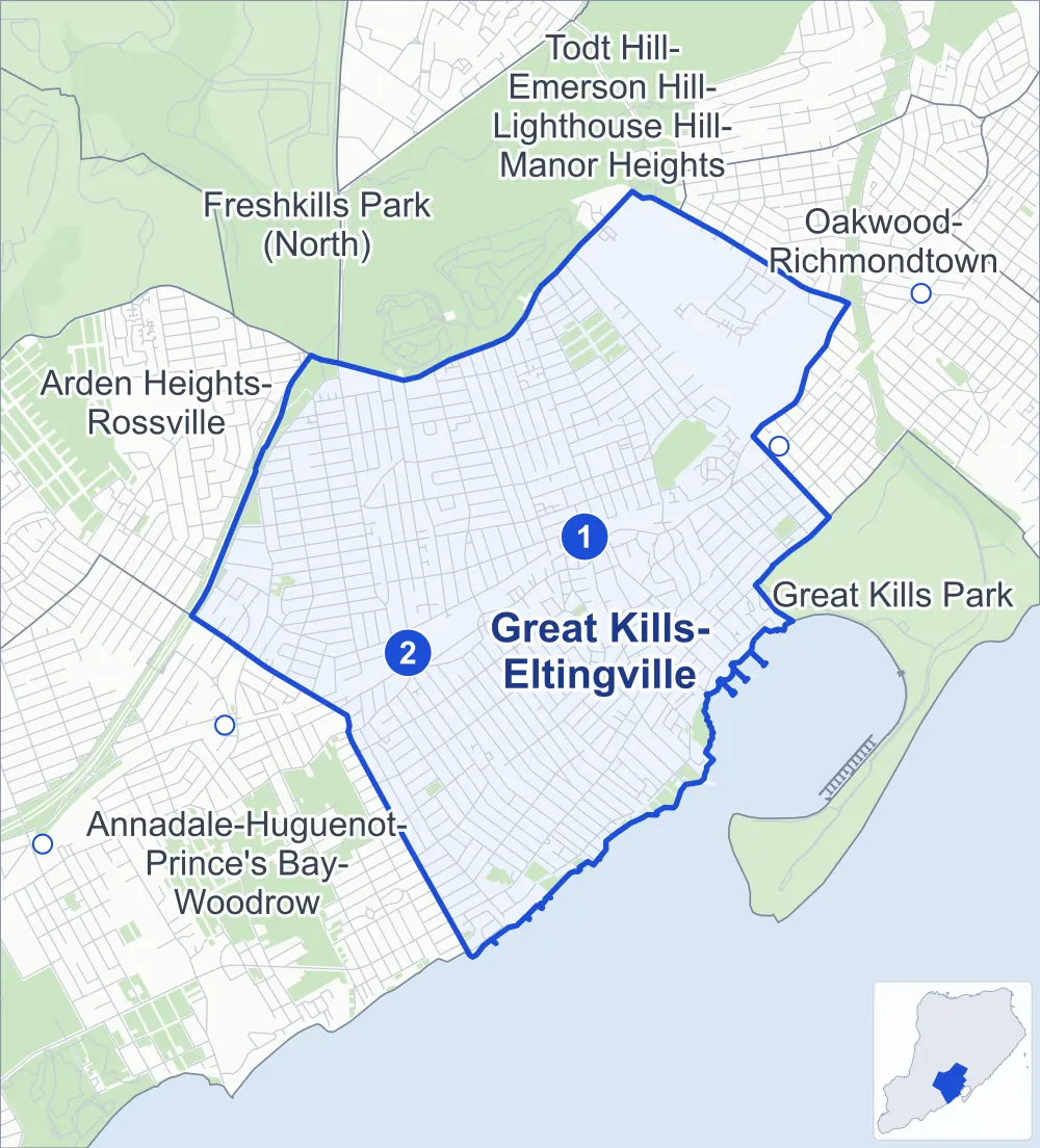
- Great Kills-Eltingville
- A neighboring area
- Park
- A station in the list
- Another station
Neighborhood areas and streets: NYC Department of City Planning. Parks: NYC Parks. Stations: MTA.
Neighboring areas
- Todt Hill-Emerson Hill-Lighthouse Hill-Manor Heights north
- Oakwood-Richmondtown northeast
- Great Kills Park east
- Annadale-Huguenot-Prince's Bay-Woodrow southwest
- Arden Heights-Rossville west
- Freshkills Park (North) northwest
Staten Island Railway stations
- Great Kills lines SIR accessible
- Eltingville lines SIR
Getting around
The Staten Island Railway stops at Eltingville and Great Kills, and buses on 23 routes stop in or at the edge of Great Kills-Eltingville.
- 2 Staten Island Railway stations
- 1 of them listed by the MTA as fully accessible
- 9 local bus routes
- 14 express bus routes
Local bus routes
- S54
- S55
- S56
- S59
- S74
- S78
- S79-SBS
- S84
- S89
Express bus routes
- SIM1
- SIM1C
- SIM4
- SIM4C
- SIM5
- SIM6
- SIM7
- SIM8
- SIM9
- SIM10
- SIM15
- SIM22
- SIM23
- SIM31
Safety record
Between 2021 and 2025, its corners averaged fewer police-reported crashes than the average Staten Island corner.
- 1,296 police-reported crashes at its corners
- 1.7 a corner, on average
- 2.2 the average Staten Island corner
- 362 corners with a clean record
Signal or safety changes on City record, at 44 of its corners
- Accessible pedestrian signals
- 44
- Leading pedestrian intervals
- 15
- Turn calming
- 5
Camera tickets
In 2025 its corners had more school-zone speed camera tickets than red-light or bus-lane tickets.
- 4,896 red-light camera tickets at one corner
- 40,923 school-zone speed camera tickets at 23 corners
- 0 bus-lane camera tickets
- Most red-light tickets
- Arthur Kill Road & Richmond Avenue, 4,896
- Most speed tickets
- Hylan Boulevard & Ainsworth Avenue, 13,882
People and homes
The 2020 Census counted 54,699 residents in Great Kills-Eltingville, about 13,100 per square mile.
- 21,100 homes, 2020 Census
- 633 homes added since April 2010, net, by City Planning's count
Half of its 15,529 residential lots hold buildings from 1975 or earlier, and 8% of them date from before 1940, by the City's tax lot records.
Parks and landmarks
- Parkland
- 77.4 acres of NYC Parks property
- The largest pieces
- Siedenburg Park (22.9 acres), King Fisher Park (16.8 acres) and Crescent Beach Park (15.6 acres)
- Designated landmarks
- Saint Alban's Episcopal Church and the Frederick Douglass Memorial Park Office Building
Streets and trees
- Trees
- 15,857 in NYC Parks' records, most often Callery pear, red maple and sweetgum
- Street with the most corners
- Richmond Avenue, with 39 of the area's 752
- Height above sea level
- From 4 feet at Tennyson Drive & Goodall Street to 123 feet at Sycamore Street & Woods of Arden Road
- Honorary street names
- 44 at its corners, enacted by local law
Schools and libraries
The City lists nine schools and two libraries in Great Kills-Eltingville.
- Public schools
- 7
- Charter and private schools
- 2
- Libraries
- Great Kills Library and Richmondtown Library
Public safety
How complaints are countedIn 2025 the NYPD recorded 191 major felonies at places in Great Kills-Eltingville.
Recorded by the NYPD at places in Great Kills-Eltingville
- 213 major felonies in 2024
- 870 other felonies, misdemeanors and violations in 2025
In 2025, on the streets along the edge of Great Kills-Eltingville, the NYPD recorded another 23 major felonies. Counting the streets along its edge, in 2025 the NYPD recorded 3.9 major felonies for every thousand residents the 2020 Census counted in Great Kills-Eltingville.
- Police precincts
- 122nd (most of the area), 123rd
From January to June 2026 the NYPD recorded 97 major felonies at places in Great Kills-Eltingville, against 89 in the same months of 2025.
Sources: the NYPD's Complaint Data Historic, updated April 28, 2026, and Complaint Data Current (Year To Date), updated July 27, 2026, on NYC Open Data. Figures to June 30, 2026.
Street corners
- Abingdon Avenue & Abingdon Court
- Abingdon Avenue & East Augusta Avenue
- Abingdon Avenue & East Brandis Avenue
- Abingdon Avenue & East Figurea Avenue
- Abingdon Avenue & East Macon Avenue
- Abingdon Avenue & East Reading Avenue
- Abingdon Avenue & East Scranton Avenue
- Abingdon Avenue & East Stroud Avenue
- Abingdon Avenue & Gurley Avenue
- Abingdon Court & Abbey Road
- Abingdon Court & Lennon Court
- Acacia Avenue & Oceanview Place
- Adrienne Place & Clovis Road
- Ainsworth Avenue & Maybury Avenue
- Amber Street & Boyce Avenue
- Amboy Road & Acacia Avenue
- Amboy Road & Adrienne Place
- Amboy Road & Armstrong Avenue
- Amboy Road & Bamberger Lane
- Amboy Road & Bay Terrace
- Amboy Road & Bovanizer Street
- Amboy Road & Brown Avenue
- Amboy Road & Chesterton Avenue
- Amboy Road & Colon Avenue
- Amboy Road & Cranford Street
- Amboy Road & Fairbanks Avenue
- Amboy Road & Fieldway Avenue
- Amboy Road & Giffords Lane
- Amboy Road & Greaves Avenue
- Amboy Road & Highland Road
- Amboy Road & Hillside Terrace
- Amboy Road & Justin Avenue
- Amboy Road & Keegans Lane
- Amboy Road & Lindenwood Road
- Amboy Road & Lyndale Avenue
- Amboy Road & Midland Road
- Amboy Road & Montreal Avenue
- Amboy Road & Nelson Avenue
- Amboy Road & Nolan Avenue
- Amboy Road & Old Amboy Road
- Amboy Road & Preston Avenue
- Amboy Road & Putnam Street
- Amboy Road & Retford Avenue
- Amboy Road & Richmond Avenue
- Amboy Road & Ridgecrest Avenue
- Amboy Road & Ross Lane
- Amboy Road & Saccheri Court
- Amboy Road & Seeley Lane
- Amboy Road & Seidman Avenue
- Amboy Road & Sherwood Place
- Amboy Road & South Railroad Avenue
- Amboy Road & South Railroad Avenue at Ainsworth Avenue
- Amboy Road & Timber Ridge Drive
- Annadale Road & Figurea Avenue
- Annadale Road & Genesee Avenue
- Annadale Road & Grantwood Avenue
- Annadale Road & Katan Avenue
- Annadale Road & Laredo Avenue
- Annadale Road & Leverett Avenue
- Annadale Road & Notus Avenue
- Annadale Road & Wolcott Avenue
- Arden Avenue & Blue Heron Drive
- Arden Avenue & Detroit Avenue
- Arden Avenue & Eylandt Street
- Arden Avenue & Jeannette Avenue
- Arden Avenue & Kinghorn Street
- Arden Avenue & Koch Boulevard
- Arden Avenue & Moffett Street
- Arden Avenue & Pompey Avenue
- Arden Avenue & Sandgap Street
- Arden Avenue & Shirley Avenue
- Arden Avenue & Van Brunt Street
- Arkansas Avenue & Lexington Lane
- Armstrong Avenue & Barlow Avenue
- Armstrong Avenue & Bennington Street
- Armstrong Avenue & East Augusta Avenue
- Armstrong Avenue & East Brandis Avenue
- Armstrong Avenue & East Figurea Avenue
- Armstrong Avenue & East Macon Avenue
- Armstrong Avenue & East Perkiomen Avenue
- Armstrong Avenue & East Reading Avenue
- Armstrong Avenue & Genesee Avenue
- Armstrong Avenue & Gurley Avenue
- Armstrong Avenue & Highland Lane
- Armstrong Avenue & Hillcrest Street
- Armstrong Avenue & Katan Avenue
- Armstrong Avenue & King Street
- Armstrong Avenue & Lamoka Avenue
- Armstrong Avenue & Leverett Avenue
- Armstrong Avenue & Middle Loop Road at East Scranton Avenue
- Armstrong Avenue & Middle Loop Road at East Stroud Avenue
- Armstrong Avenue & Oakdale Street
- Armstrong Avenue & Oceanview Place
- Armstrong Avenue & Old Amboy Road
- Armstrong Avenue & Sycamore Street
- Armstrong Avenue & Wilson Avenue
- Arthur Kill Road & Abbey Road
- Arthur Kill Road & Cortelyou Avenue
- Arthur Kill Road & Drumgoole Road West
- Arthur Kill Road & Eltingville Transit Center Driveway
- Arthur Kill Road & Elverton Avenue
- Arthur Kill Road & Getz Avenue
- Arthur Kill Road & Lennon Court
- Arthur Kill Road & Richmond Avenue
- Arthur Kill Road & Ridgewood Avenue
- Arthur Kill Road & Troy Street
- Augusta Avenue & Lovelace Avenue
- Baltimore Street & Hardy Place
- Baltimore Street & Rhett Avenue
- Barlow Avenue & Abingdon Avenue
- Barlow Avenue & Barlow Court
- Barlow Avenue & Bartlett Avenue
- Barlow Avenue & Brookfield Avenue
- Barlow Avenue & Colon Avenue
- Barlow Avenue & Corbin Avenue
- Barlow Avenue & Cortelyou Avenue
- Barlow Avenue & Doane Avenue
- Barlow Avenue & Eltingville Boulevard
- Barlow Avenue & Elverton Avenue
- Barlow Avenue & Fenway Circle
- Barlow Avenue & Getz Avenue
- Barlow Avenue & Giffords Lane
- Barlow Avenue & Greaves Avenue
- Barlow Avenue & Miles Avenue
- Barlow Avenue & Pompey Avenue
- Barlow Avenue & Ridgewood Avenue
- Barlow Avenue & Stieg Avenue
- Barlow Avenue & Wainwright Avenue
- Beach Road & Hillcrest Street
- Beach Road & St Albans Place
- Blythe Place & Dina Court
- Bovanizer Street & Gillard Avenue
- Boyce Avenue & Ilyse Court
- Boyce Avenue & Lyle Court
- Brandis Avenue & Brandis Lane
- Brookfield Avenue & Gurley Avenue
- Carlton Boulevard & Detroit Avenue
- Chess Loop & Knight Loop
- Chess Loop & Newvale Avenue
- Clarke Avenue & Cotter Avenue
- Clarke Avenue & Gianna Court
- Clarke Avenue & Joshua Court
- Clarke Avenue & Kensico Street
- Clarke Avenue & McKinley Avenue
- Clarke Avenue & Rene Drive
- Cleveland Avenue & Ackerman Street
- Cleveland Avenue & Cornish Street
- Cleveland Avenue & Grandview Terrace
- Cleveland Avenue & Hartford Street
- Cleveland Avenue & Locust Place
- Cleveland Avenue & Melrose Place
- Cleveland Avenue & Mercer Place
- Cleveland Avenue & Nash Court
- Cleveland Avenue & Rustic Place
- Cloverdale Avenue & Oceanview Place
- Colon Avenue & Dewey Avenue
- Colon Avenue & Gurley Avenue
- Colon Avenue & Katan Loop
- Colon Avenue & Margaret Street
- Corbin Avenue & Country Woods Lane
- Corbin Avenue & Daleham Street
- Corbin Avenue & Dewey Avenue
- Corbin Avenue & Elkhart Street
- Corbin Avenue & Fairfield Street
- Corbin Avenue & Ironwood Street
- Corbin Avenue & Jumel Street
- Corbin Avenue & Kennington Street
- Corbin Avenue & Nahant Street
- Corbin Avenue & Willowwood Lane
- Corona Avenue & Atmore Place
- Corona Avenue & Blythe Place
- Corona Avenue & Cotter Avenue
- Corona Avenue & Croft Court
- Corona Avenue & Elise Court
- Corona Avenue & Elk Court
- Corona Avenue & Fuller Court
- Corona Avenue & Garth Court
- Corona Avenue & Hart Loop (east)
- Corona Avenue & Hart Loop (west)
- Corona Avenue & Peck Court
- Cortelyou Avenue & East Brandis Avenue
- Cortelyou Avenue & East Figurea Avenue
- Cortelyou Avenue & East Macon Avenue
- Cotter Avenue & Blythe Place
- Cotter Avenue & Boyce Avenue
- Cotter Avenue & Dina Court
- Crispi Lane & Dockside Lane
- Daleham Street & Troy Street
- David Street & Osborne Avenue
- David Street & William Avenue
- Dewey Avenue & Dewey Place
- Dewey Avenue & Dunbar Street
- Dewey Avenue & Exeter Street
- Dewey Avenue & North Rhett Avenue
- Dewey Avenue & Sampson Avenue
- Dewey Avenue & Schley Avenue
- Dewey Avenue & Shafter Avenue
- Dewey Avenue & Tudor Street
- Dina Court & Ilyse Court
- Driggs Street & Osborne Avenue
- Driggs Street & William Avenue
- Drumgoole Road East & Andrea Court
- Drumgoole Road East & Annadale Road
- Drumgoole Road East & Barlow Avenue
- Drumgoole Road East & Brandis Avenue
- Drumgoole Road East & Genesee Avenue
- Drumgoole Road East & Kathy Court
- Drumgoole Road East & Lamont Avenue
- Drumgoole Road East & Lamont Avenue at Carlton Boulevard
- Drumgoole Road East & Macon Avenue
- Drumgoole Road East & Marne Avenue
- Drumgoole Road East & Monterey Avenue
- Drumgoole Road East & Notus Avenue
- Drumgoole Road East & Richmond Parkway
- Drumgoole Road East & Sally Court
- Drumgoole Road East & Wainwright Avenue
- Drumgoole Road East & Wolcott Avenue
- Durant Avenue & Ainsworth Avenue
- Durant Avenue & Bartow Street
- Durant Avenue & Cleveland Avenue
- Durant Avenue & Cranford Street
- Durant Avenue & Fieldway Avenue
- Durant Avenue & Hillside Terrace
- Durant Avenue & Keegans Lane
- Durant Avenue & Redgrave Avenue
- Durant Avenue & Taunton Street
- Edgegrove Avenue & Grantwood Avenue
- Eleanor Lane & Hilltop Place
- Elmwood Avenue & Oceanview Place
- Eltingville Boulevard & Coryn Court
- Eltingville Boulevard & Gurley Avenue
- Elverton Avenue & Arkansas Avenue
- Elverton Avenue & Eric Lane
- Elverton Avenue & Gurley Avenue
- Elverton Avenue & Lexington Lane
- Evergreen Street & Redwood Avenue
- Exeter Street & Howton Avenue
- Exeter Street & Nahant Street
- Fairlawn Loop & Fairlawn Avenue
- Fieldway Avenue & Keats Street
- Fieldway Avenue & Maybury Avenue
- Fieldway Avenue & Trent Street
- Figurea Avenue & Lovelace Avenue
- Fitzgerald Avenue & Morris Place
- Florence Street & Tarlee Place
- Genesee Avenue & Abingdon Avenue
- Genesee Avenue & Brookfield Avenue
- Genesee Avenue & Colon Avenue
- Genesee Avenue & Cortelyou Avenue
- Genesee Avenue & Eltingville Boulevard
- Genesee Avenue & Getz Avenue
- Genesee Avenue & Lovelace Avenue
- Genesee Avenue & Pompey Avenue
- Genesee Avenue & Ridgewood Avenue
- Genesee Avenue & Stanley Circle (east)
- Genesee Avenue & Stanley Circle (west)
- Genesee Avenue & Sweetbrook Road
- Getz Avenue & Gurley Avenue
- Getz Avenue & Opp Court
- Getz Avenue & Sweetbrook Road
- Gibson Avenue & Exeter Street
- Gibson Avenue & Sampson Avenue
- Giffords Glen & Nolan Avenue
- Giffords Lane & Baltimore Street
- Giffords Lane & Brower Court
- Giffords Lane & Daleham Street
- Giffords Lane & Dewey Avenue
- Giffords Lane & Dorit Court
- Giffords Lane & Elkhart Street
- Giffords Lane & Eric Lane
- Giffords Lane & Fairfield Street
- Giffords Lane & Gibson Avenue
- Giffords Lane & Gurley Avenue
- Giffords Lane & Hereford Street
- Giffords Lane & Howton Avenue
- Giffords Lane & Islington Street
- Giffords Lane & Jumel Street
- Giffords Lane & Margaret Street
- Giffords Lane & Michael Court
- Giffords Lane & Teresa Lane
- Giffords Lane & Woodland Avenue
- Grantwood Avenue & Detroit Avenue
- Great Kills Road & Coral Court
- Great Kills Road & Cottage Avenue
- Great Kills Road & Dent Road
- Great Kills Road & Mansion Avenue
- Great Kills Road & Maybury Avenue
- Great Kills Road & Ocean Road
- Greaves Avenue & Cromer Street
- Greaves Avenue & Daleham Street
- Greaves Avenue & Dewey Avenue
- Greaves Avenue & Dewey Place
- Greaves Avenue & Elkhart Street
- Greaves Avenue & Fairfield Street
- Greaves Avenue & Gibson Avenue
- Greaves Avenue & Greaves Court
- Greaves Avenue & Greaves Lane
- Greaves Avenue & Howton Avenue
- Greaves Avenue & Jumel Street
- Greaves Avenue & Kennington Street
- Greaves Avenue & Nahant Street
- Greaves Avenue & Oak Court
- Greaves Avenue & Stonecrest Court
- Greaves Court & Exeter Street
- Greaves Lane & Stern Court
- Greencroft Avenue & Ainsworth Avenue
- Greencroft Avenue & Bay Terrace
- Greencroft Avenue & Fieldway Avenue
- Greencroft Avenue & Great Kills Road
- Greencroft Avenue & Greencroft Lane
- Greencroft Avenue & Keegans Lane
- Greencroft Avenue & Redgrave Avenue
- Gurley Avenue & Bartlett Avenue
- Gurley Avenue & Doane Avenue
- Gurley Avenue & Pemberton Avenue
- Hales Avenue & Liss Street
- Hales Avenue & Oban Street
- Hales Avenue & Osage Lane
- Heinz Avenue & Filipe Lane
- Highland Lane & Point Street
- Highland Road & Dent Road
- Highland Road & Ocean Road
- Hillcrest Avenue & Eleanor Lane
- Hillcrest Avenue & Highmount Road
- Hillcrest Avenue & Park Terrace
- Hillcrest Street & Osborne Avenue
- Hillcrest Street & William Avenue
- Hillcrest Street & Wiman Avenue
- Hillside Terrace & Adrienne Place
- Hillside Terrace & Cottage Avenue
- Hillside Terrace & Dent Road
- Hillside Terrace & Grandview Terrace
- Hillside Terrace & Locust Place
- Hillside Terrace & Mansion Avenue
- Hillside Terrace & Rustic Place
- Holly Avenue & Beth Place
- Holly Avenue & Eleanor Lane
- Howton Avenue & Linton Place
- Hylan Boulevard & Ainsworth Avenue
- Hylan Boulevard & Armstrong Avenue
- Hylan Boulevard & Bay Terrace
- Hylan Boulevard & Cleveland Avenue
- Hylan Boulevard & Fieldway Avenue
- Hylan Boulevard & Glover Street
- Hylan Boulevard & Gravel Road Esplanade
- Hylan Boulevard & Groton Street
- Hylan Boulevard & Hales Avenue
- Hylan Boulevard & Heinz Avenue
- Hylan Boulevard & Hillside Terrace
- Hylan Boulevard & Jughandle
- Hylan Boulevard & Keegans Lane
- Hylan Boulevard & Nelson Avenue
- Hylan Boulevard & Pacific Avenue
- Hylan Boulevard & Preston Avenue
- Hylan Boulevard & Retford Avenue
- Hylan Boulevard & Richmond Avenue
- Hylan Boulevard & Robinson Avenue
- Hylan Boulevard & Seacrest Avenue
- Hylan Boulevard & Thornycroft Avenue
- Hylan Boulevard & Wiman Avenue
- Hylan Boulevard & Woods of Arden Road
- Hylan Boulevard & Yacht Club Cove
- Ilyse Court & Lyle Court
- Ionia Avenue & Carlton Boulevard
- Katan Avenue & Abingdon Avenue
- Katan Avenue & Bartlett Avenue
- Katan Avenue & Brookfield Avenue
- Katan Avenue & Colon Avenue
- Katan Avenue & Cortelyou Avenue
- Katan Avenue & Demopolis Avenue
- Katan Avenue & Eltingville Boulevard
- Katan Avenue & Exeter Street
- Katan Avenue & Fern Avenue
- Katan Avenue & Getz Avenue
- Katan Avenue & Giffords Lane
- Katan Avenue & Greaves Avenue
- Katan Avenue & Katan Loop
- Katan Avenue & Miles Avenue
- Katan Avenue & North Rhett Avenue
- Katan Avenue & Notre Dame Avenue
- Katan Avenue & Pompey Avenue
- Katan Avenue & Rhett Avenue
- Katan Avenue & Ridgewood Avenue
- Katan Avenue & Sampson Avenue
- Katan Avenue & Schley Avenue
- Katan Avenue & Shafter Avenue
- Katan Avenue & Wainwright Avenue
- Keegans Lane & Keats Street
- Keegans Lane & Trent Street
- King Street & Beach Road
- King Street & Hales Avenue
- King Street & Orchard Lane South
- King Street & Osborne Avenue
- King Street & Pacific Avenue
- King Street & William Avenue
- Kinghorn Street & Hales Avenue
- Knight Loop & Newvale Avenue
- Koch Boulevard & Hales Avenue
- Koch Boulevard & Lyndale Avenue
- Koch Boulevard & Preston Avenue
- Koch Boulevard & Retford Avenue
- Koch Boulevard & Seidman Avenue
- Koch Boulevard & Woods of Arden Road
- Korean War Vets Parkway & Annadale Road
- Lamoka Avenue & Abingdon Avenue
- Lamoka Avenue & Bartlett Avenue
- Lamoka Avenue & Brookfield Avenue
- Lamoka Avenue & Colon Avenue
- Lamoka Avenue & Cortelyou Avenue
- Lamoka Avenue & Demopolis Avenue
- Lamoka Avenue & Eltingville Boulevard
- Lamoka Avenue & Escanaba Avenue
- Lamoka Avenue & Exeter Street
- Lamoka Avenue & Fern Avenue
- Lamoka Avenue & Getz Avenue
- Lamoka Avenue & Memphis Avenue
- Lamoka Avenue & Notre Dame Avenue
- Lamoka Avenue & Pompey Avenue
- Lamoka Avenue & Ridgewood Avenue
- Lamoka Avenue & Sampson Avenue
- Lamoka Avenue & Wainwright Avenue
- Leverett Avenue & Abingdon Avenue
- Leverett Avenue & Bartlett Avenue
- Leverett Avenue & Brookfield Avenue
- Leverett Avenue & Colon Avenue
- Leverett Avenue & Cortelyou Avenue
- Leverett Avenue & Doane Avenue
- Leverett Avenue & Elverton Avenue
- Leverett Avenue & Giffords Lane
- Leverett Avenue & Greaves Avenue
- Leverett Avenue & Leverett Court
- Leverett Avenue & Linton Place
- Leverett Avenue & Lovelace Avenue
- Leverett Avenue & Miles Avenue
- Leverett Avenue & Pompey Avenue
- Leverett Avenue & Ridgewood Avenue
- Leverett Avenue & Stieg Avenue
- Leverett Avenue & Wainwright Avenue
- Lindenwood Road & Baltimore Street
- Lindenwood Road & Edgewood Road
- Lindenwood Road & Giffords Glen
- Lindenwood Road & Highmount Road
- Lindenwood Road & Hillcrest Avenue
- Lindenwood Road & Hilltop Place
- Lindenwood Road & Park Terrace
- Lindenwood Road & Pleasant Street
- Lindenwood Road & Scarsdale Street
- Lindenwood Road & School Street
- Lindenwood Road & Wiman Avenue
- Luke Court & Sable Loop
- Lyndale Avenue & King Street
- Lyndale Avenue & Lyndale Lane
- Lyndale Avenue & Shirley Avenue
- Mansion Avenue & McKee Avenue
- Mansion Avenue & Osprey Court
- Mansion Avenue & Whitman Avenue
- Margaret Street & Hardy Place
- Margaret Street & Rhett Avenue
- Mayberry Promenade & Blueberry Lane
- Mayberry Promenade & Strawberry Lane (north-east)
- Mayberry Promenade & Strawberry Lane (south-west)
- Maybury Avenue & Keegans Lane
- Meadow Lane & Willow Lane
- Midland Road & Clinton Road
- Midland Road & Dent Road
- Midland Road & Ocean Road
- Midland Road & Ramble Road
- Midland Road & Rustic Place
- Miles Avenue & Cromer Street
- Miles Avenue & Daleham Street
- Miles Avenue & Dewey Avenue
- Miles Avenue & Elkhart Street
- Miles Avenue & Fairfield Street
- Miles Avenue & Gibson Avenue
- Miles Avenue & Gurley Avenue
- Miles Avenue & Hereford Street
- Miles Avenue & Islington Street
- Miles Avenue & Jumel Street
- Miles Avenue & Kennington Street
- Mosely Avenue & Bamberger Lane
- Mosely Avenue & Bovanizer Street
- Mosely Avenue & Vanessa Lane
- Mosely Avenue & Waimer Place
- Nahant Street & Dunbar Street
- Nahant Street & Tudor Street
- Nelson Avenue & Belden Street
- Nelson Avenue & Brower Court
- Nelson Avenue & Crispi Lane
- Nelson Avenue & David Street
- Nelson Avenue & Dockside Lane
- Nelson Avenue & Driggs Street
- Nelson Avenue & Edgewood Road
- Nelson Avenue & Fitzgerald Avenue
- Nelson Avenue & Florence Street
- Nelson Avenue & Giffords Glen
- Nelson Avenue & Grandview Terrace
- Nelson Avenue & Hartford Street
- Nelson Avenue & Hillcrest Street
- Nelson Avenue & Locust Place
- Nelson Avenue & Nash Court
- Nelson Avenue & Nelson Avenue Footbridge
- Nelson Avenue & Presley Street
- Nelson Avenue & Rustic Place
- Nelson Avenue & Sweetwater Avenue
- Nelson Avenue & Tennyson Drive
- O'Gorman Avenue & Ainsworth Avenue
- O'Gorman Avenue & Bartow Street
- O'Gorman Avenue & Bay Terrace
- O'Gorman Avenue & Cranford Street
- O'Gorman Avenue & Fieldway Avenue
- O'Gorman Avenue & Keegans Lane
- O'Gorman Avenue & Redgrave Avenue
- O'Gorman Avenue & Taunton Street
- Oakdale Street & Acacia Avenue
- Oakdale Street & Beach Road
- Oakdale Street & Cloverdale Avenue
- Oakdale Street & Elmwood Avenue
- Oakdale Street & Holly Avenue
- Oakdale Street & Lyndale Avenue
- Oakdale Street & Montvale Place
- Oakdale Street & Pacific Avenue
- Oakdale Street & Preston Avenue
- Oakdale Street & Ramblewood Avenue
- Oakdale Street & Retford Avenue
- Oakdale Street & Ridgecrest Avenue
- Oakdale Street & Robinson Avenue
- Oakdale Street & Ross Lane
- Oakdale Street & Seeley Lane
- Oakdale Street & Seidman Avenue
- Oakdale Street & Thornycroft Avenue
- Oakdale Street & Winchester Avenue
- Oakdale Street & Woods of Arden Road
- Oceanview Place & Eleanor Lane
- Old Amboy Road & Greaves Lane
- Old Amboy Road & Timber Ridge Drive
- Old Amboy Road & Willow Lane
- Osage Lane & Orchard Lane
- Pacific Avenue & Beach Road
- Pacific Avenue & Hillcrest Street
- Pacific Avenue & St Albans Place
- Pemberton Avenue & Eric Lane
- Perona Lane & Dockside Lane
- Petrus Avenue & Bayard Street
- Petrus Avenue & Chesebrough Street
- Pompey Avenue & Adlai Circle
- Pompey Avenue & Augusta Avenue
- Pompey Avenue & Figurea Avenue
- Pompey Avenue & Laredo Avenue
- Pompey Avenue & Marne Avenue
- Pompey Avenue & Memphis Avenue
- Pompey Avenue & Monterey Avenue
- Pompey Avenue & Petrus Avenue
- Pompey Avenue & Ray Street
- Pompey Avenue & Rye Avenue
- Pompey Avenue & Scranton Avenue
- Pompey Avenue & Serrell Avenue
- Pompey Avenue & Stroud Avenue
- Preston Avenue & Berkley Street
- Preston Avenue & Eastman Street
- Preston Avenue & King Street
- Preston Avenue & Ogden Street
- Preston Avenue & Osborne Street
- Preston Avenue & Rankin Street
- Preston Avenue & Shirley Avenue
- Ramble Road & Adrienne Place
- Ramble Road & Dent Road
- Ramblewood Avenue & Oceanview Place
- Redgrave Avenue & Maybury Court
- Redwood Avenue & Ashwood Court
- Retford Avenue & King Street
- Retford Avenue & Shirley Avenue
- Retford Avenue & Tennyson Drive
- Richmond Avenue & Augusta Avenue
- Richmond Avenue & Barlow Avenue
- Richmond Avenue & Bartlett Avenue
- Richmond Avenue & Brandis Avenue
- Richmond Avenue & Drumgoole Road East
- Richmond Avenue & Eltingville Boulevard
- Richmond Avenue & Figurea Avenue
- Richmond Avenue & Gabrielle Court
- Richmond Avenue & Genesee Avenue
- Richmond Avenue & Hilltop Road
- Richmond Avenue & Katan Avenue
- Richmond Avenue & King Street
- Richmond Avenue & Koch Boulevard
- Richmond Avenue & Lamoka Avenue
- Richmond Avenue & Laredo Avenue
- Richmond Avenue & Leverett Avenue
- Richmond Avenue & Lyndale Lane
- Richmond Avenue & Macon Avenue
- Richmond Avenue & Memphis Avenue
- Richmond Avenue & Mosely Avenue
- Richmond Avenue & Oakdale Street
- Richmond Avenue & Park Road
- Richmond Avenue & Perkiomen Avenue
- Richmond Avenue & Petrus Avenue
- Richmond Avenue & Prol Place
- Richmond Avenue & Reading Avenue
- Richmond Avenue & Scranton Avenue
- Richmond Avenue & Serrell Avenue
- Richmond Avenue & Shirley Avenue
- Richmond Avenue & Star Court
- Richmond Avenue & Stroud Avenue
- Richmond Avenue & Sycamore Street
- Richmond Avenue & Sylvia Street
- Richmond Avenue & Tennyson Drive
- Richmond Avenue & Wainwright Avenue
- Richmond Avenue & Wilson Avenue
- Ridgecrest Avenue & Crest Loop
- Ridgecrest Avenue & Hilltop Road
- Ridgecrest Avenue & King Street
- Ridgecrest Avenue & Park Road
- Ridgewood Avenue & Frank Court
- Ridgewood Avenue & Gil Court
- Ridgewood Avenue & Maria Lane
- Ridgewood Avenue & Opp Court
- Ridgewood Avenue & Patty Court
- Ridgewood Avenue & Sweetbrook Road
- Robinson Avenue & Hillcrest Street
- Robinson Avenue & King Street
- Robinson Avenue & St Albans Place
- Russell Street & Lillian Place
- Russell Street & Osborne Avenue
- Russell Street & William Avenue
- Rye Avenue & Petrus Avenue
- Rye Avenue & Van Brunt Street
- Sandalwood Drive & Cherrywood Court
- Sandalwood Drive & Cottonwood Court
- Sandalwood Drive & Country Woods Lane
- Sandalwood Drive & Ironwood Street
- Sandalwood Drive & Redwood Avenue
- Sandalwood Drive & Willowwood Lane
- Scarsdale Street & School Street
- Scranton Avenue & Lovelace Avenue
- Seeley Lane & Pleasant Street
- Seeley Lane & Scarsdale Street
- Seeley Lane & School Street
- Serrell Avenue & Moffett Street
- Shafter Avenue & Gibson Avenue
- Shirley Avenue & Hales Avenue
- Shirley Avenue & Orchard Lane
- Shirley Avenue & Seidman Avenue
- South Railroad Avenue & Bartow Street
- South Railroad Avenue & Redgrave Avenue
- South Railroad Avenue & Taunton Street
- Stroud Avenue & Lovelace Avenue
- Sycamore Street & Acacia Avenue
- Sycamore Street & Beach Road
- Sycamore Street & Cloverdale Avenue
- Sycamore Street & Elmwood Avenue
- Sycamore Street & Hillcrest Avenue
- Sycamore Street & Holly Avenue
- Sycamore Street & Lyndale Avenue
- Sycamore Street & Pacific Avenue
- Sycamore Street & Preston Avenue
- Sycamore Street & Ramblewood Avenue
- Sycamore Street & Retford Avenue
- Sycamore Street & Ridgecrest Avenue
- Sycamore Street & Robinson Avenue
- Sycamore Street & Seidman Avenue
- Sycamore Street & Thornycroft Avenue
- Sycamore Street & Winchester Avenue
- Sycamore Street & Woods of Arden Road
- Sylvia Street & Stuyvesant Avenue
- Tanglewood Drive & Country Woods Lane
- Tanglewood Drive & Nutwood Court
- Tanglewood Drive & Teakwood Court
- Tennyson Drive & Filipe Lane
- Tennyson Drive & Glover Street
- Tennyson Drive & Goodall Street
- Tennyson Drive & Groton Street
- Tennyson Drive & Harbour Court
- Tennyson Drive & Littlefield Avenue
- Tennyson Drive & Oceanic Avenue
- Tennyson Drive & Perona Lane
- Tennyson Drive & Point Street
- Tennyson Drive & Prol Place
- Tennyson Drive & Seacrest Avenue
- Tennyson Drive & Thornycroft Avenue
- Tennyson Drive & Wiman Avenue
- Tennyson Drive & Winchester Avenue
- Thornycroft Avenue & Hillcrest Street
- Thornycroft Avenue & King Street
- Timber Ridge Drive & Cardinal Lane
- Timber Ridge Drive & Fawn Lane
- Timber Ridge Drive & Meadow Lane (north)
- Timber Ridge Drive & Meadow Lane (south)
- Timber Ridge Drive & Nancy Court
- Van Brunt Street & Bent Street
- Van Brunt Street & Ray Street
- Wainwright Avenue & Augusta Avenue
- Wainwright Avenue & Brandis Avenue
- Wainwright Avenue & Brandis Lane
- Wainwright Avenue & Eltingville Transit Center Driveway
- Wainwright Avenue & Figurea Avenue
- Wainwright Avenue & Genesee Avenue
- Wainwright Avenue & Laredo Avenue
- Wainwright Avenue & Macon Avenue
- Wainwright Avenue & Memphis Avenue
- Wainwright Avenue & Perkiomen Avenue
- Wainwright Avenue & Petrus Avenue
- Wainwright Avenue & Reading Avenue
- Wainwright Avenue & Rochelle Place
- Wainwright Avenue & Rye Avenue
- Wainwright Avenue & Scranton Avenue
- Wainwright Avenue & Serrell Avenue
- Wainwright Avenue & Stroud Avenue
- Wainwright Avenue & Sylvia Street
- Wainwright Avenue & Wilson Avenue
- Walnut Avenue & Highland Lane
- Whitman Avenue & Cornish Street
- Whitman Avenue & Melrose Place
- Whitman Avenue & Mercer Place
- Willow Lane & Cardinal Lane
- Wilson Avenue & Abingdon Avenue
- Wilson Avenue & Bayard Street
- Wilson Avenue & Chesebrough Street
- Wilson Avenue & Colon Avenue
- Wilson Avenue & Cortelyou Avenue
- Wilson Avenue & Demopolis Avenue
- Wilson Avenue & Eltingville Boulevard
- Wilson Avenue & Escanaba Avenue
- Wilson Avenue & Fern Avenue
- Wilson Avenue & Notre Dame Avenue
- Wilson Avenue & Pompey Avenue
- Wilson Avenue & Ridgewood Avenue
- Wilson Avenue & Stuyvesant Avenue
- Wilson Avenue & Van Brunt Street
- Wiman Avenue & David Street
- Wiman Avenue & Driggs Street
- Wiman Avenue & Presley Street
- Wiman Avenue & Russell Street
- Wiman Avenue & Sweetwater Avenue
- Winchester Avenue & Hillcrest Street
- Winchester Avenue & King Street
- Winchester Avenue & St Albans Place
- Woodcutters Lane & Nancy Court
- Woodland Avenue & Blaise Court
- Woods of Arden Road & Bathgate Street
- Woods of Arden Road & Berkley Street
- Woods of Arden Road & Eastman Street
- Woods of Arden Road & King Street
- Woods of Arden Road & Kinghorn Street
- Woods of Arden Road & Lenzie Street
- Woods of Arden Road & Liss Street
- Woods of Arden Road & Noel Street
- Woods of Arden Road & Oban Street
- Woods of Arden Road & Osborne Street
- Woods of Arden Road & Rankin Street
- Woods of Arden Road & Shirley Avenue
- Woods of Arden Road & Wakefield Road
- Yacht Club Cove & Mansion Avenue
How the figures above are measured: Methodology.