Annadale-Huguenot-Prince's Bay-Woodrow
Neighborhood · Staten Island
On the South Shore of Staten Island, Annadale-Huguenot-Prince's Bay-Woodrow includes Annadale, Huguenot, Prince's Bay, Pleasant Plains and part of Woodrow.
- 6.47 square miles
- 40,534 residents, 2020 Census
- 792 street corners
- 4 Staten Island Railway stations
- 13 bus routes
Huguenot is named for the French Huguenots who settled here in the late 1600s and early 1700s to escape religious persecution, and Annadale was named around 1860 for Anna Seguine; the Greek Revival Seguine mansion, built about 1840 with a view of the lower bay, is a city landmark. Prince's Bay oysters were once sought as far away as London, and the brownstone Prince's Bay Lighthouse of 1864 stands in the state's Mount Loretto Unique Area.
Sources: Seguine House Designation Report (LP-0389, May 25, 1967) (NYC Landmarks Preservation Commission); Prince's Bay Lighthouse Complex Designation Report (LP-0392, June 28, 2016) (NYC Landmarks Preservation Commission); Huguenot, Staten Island (Wikipedia); Annadale, Staten Island (Wikipedia).
Annadale-Huguenot-Prince's Bay-Woodrow borders three areas, and Amboy Road holds more of its corners than any other street, 60 of 792.
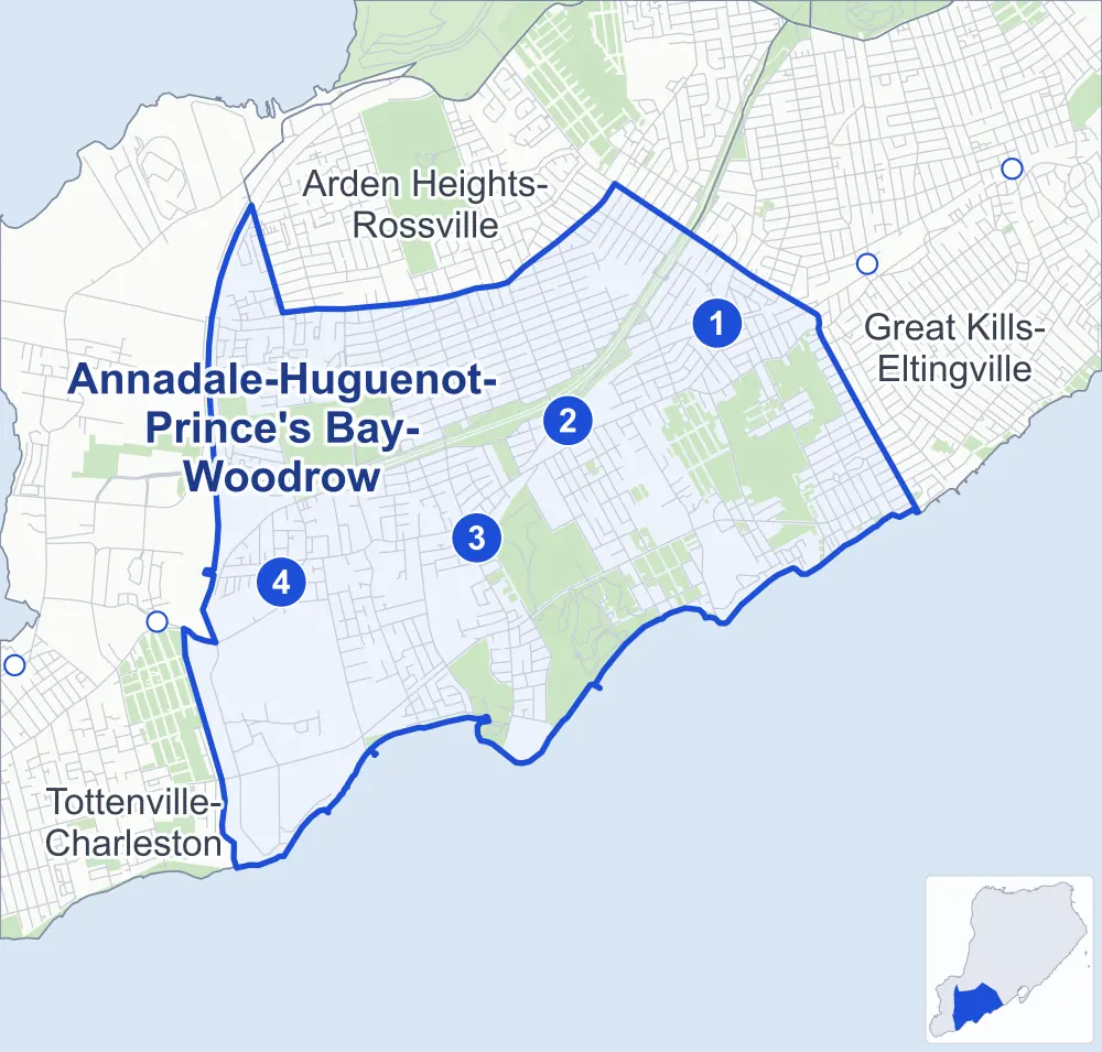
- Annadale-Huguenot-Prince's Bay-Woodrow
- A neighboring area
- Park
- A station in the list
- Another station
Neighborhood areas and streets: NYC Department of City Planning. Parks: NYC Parks. Stations: MTA.
Neighboring areas
- Arden Heights-Rossville north
- Great Kills-Eltingville northeast
- Tottenville-Charleston west
Staten Island Railway stations
- Annadale lines SIR
- Huguenot lines SIR
- Prince's Bay lines SIR
- Pleasant Plains lines SIR
Getting around
The Staten Island Railway stops at Annadale, Huguenot, Pleasant Plains and Prince's Bay, and buses on 13 routes stop in or at the edge of Annadale-Huguenot-Prince's Bay-Woodrow.
- 4 Staten Island Railway stations
- 6 local bus routes
- 7 express bus routes
Local bus routes
- S55
- S56
- S59
- S74
- S78
- S84
Express bus routes
- SIM2
- SIM4C
- SIM8
- SIM23
- SIM24
- SIM25
- SIM26
Safety record
Between 2021 and 2025, its corners averaged fewer police-reported crashes than the average Staten Island corner.
- 895 police-reported crashes at its corners
- 1.1 a corner, on average
- 2.2 the average Staten Island corner
- 476 corners with a clean record
Signal or safety changes on City record, at 51 of its corners
- Accessible pedestrian signals
- 48
- Leading pedestrian intervals
- 16
- Turn calming
- 4
Camera tickets
In 2025 its corners had more school-zone speed camera tickets than red-light or bus-lane tickets.
- 35 red-light camera tickets at one corner
- 64,200 school-zone speed camera tickets at 25 corners
- 0 bus-lane camera tickets
- Most red-light tickets
- Hylan Boulevard & Luten Avenue, 35
- Most speed tickets
- Amboy Road & Queensdale Street, 12,028
People and homes
The 2020 Census counted 40,534 residents in Annadale-Huguenot-Prince's Bay-Woodrow, about 6,300 per square mile.
- 15,428 homes, 2020 Census
- 1,633 homes added since April 2010, net, by City Planning's count
Half of its 11,239 residential lots hold buildings from 1986 or earlier, and 7% of them date from before 1940, by the City's tax lot records.
Parks and landmarks
- Parkland
- 706.7 acres of NYC Parks property
- The largest pieces
- Wolfe's Pond Park (248.9 acres), Blue Heron Park (217.6 acres) and Bloomingdale Park (137.9 acres)
- Designated landmarks
- The Reformed Church of Huguenot Park, the Manee-Seguine Homestead and the Rossville AME Zion Church
Streets and trees
- Trees
- 20,054 in NYC Parks' records, most often Callery pear, sweetgum and red maple
- Street with the most corners
- Amboy Road, with 60 of the area's 792
- Height above sea level
- From 4 feet at Johnston Terrace & Broken Shell Road to 147 feet at Stafford Avenue & Marcy Avenue
- Honorary street names
- 21 at its corners, enacted by local law
Schools and libraries
The City lists nine schools and one library in Annadale-Huguenot-Prince's Bay-Woodrow.
- Public schools
- 6
- Charter and private schools
- 3
- Library
- Huguenot Park Library
Public art
The City's public art inventory lists two works in Annadale-Huguenot-Prince's Bay-Woodrow: Pleasant Plains Memorial (1923) and Battle of the Bulge (2001).
- 2 works of public art
Public safety
How complaints are countedIn 2025 the NYPD recorded 148 major felonies at places in Annadale-Huguenot-Prince's Bay-Woodrow.
Recorded by the NYPD at places in Annadale-Huguenot-Prince's Bay-Woodrow
- 168 major felonies in 2024
- 784 other felonies, misdemeanors and violations in 2025
In 2025, on the streets along the edge of Annadale-Huguenot-Prince's Bay-Woodrow, the NYPD recorded another six major felonies. Counting the streets along its edge, in 2025 the NYPD recorded 3.8 major felonies for every thousand residents the 2020 Census counted in Annadale-Huguenot-Prince's Bay-Woodrow.
- Police precinct
- 123rd
From January to June 2026 the NYPD recorded 100 major felonies at places in Annadale-Huguenot-Prince's Bay-Woodrow, against 71 in the same months of 2025.
Sources: the NYPD's Complaint Data Historic, updated April 28, 2026, and Complaint Data Current (Year To Date), updated July 27, 2026, on NYC Open Data. Figures to June 30, 2026.
Street corners
- 4th Court & Oceanview Avenue
- Admiralty Loop & Commodore Drive (north-west)
- Admiralty Loop & Commodore Drive (south-east)
- Admiralty Loop & Marine Drive
- Albee Avenue & Bennett Avenue
- Albee Avenue & Buffington Avenue
- Albee Avenue & Downes Avenue
- Albee Avenue & Tenafly Place
- Albourne Avenue & Clearmont Avenue
- Albourne Avenue & Minturn Avenue
- Albourne Avenue & Parkwood Avenue
- Albourne Avenue & Queensdale Street
- Allen Place & 2nd Court
- Amboy Road & Addison Avenue
- Amboy Road & Albee Avenue
- Amboy Road & Alvine Avenue
- Amboy Road & Androvette Avenue
- Amboy Road & Annadale Road
- Amboy Road & Arbutus Avenue
- Amboy Road & Arden Avenue
- Amboy Road & Barclay Avenue
- Amboy Road & Bayview Avenue
- Amboy Road & Bedell Street
- Amboy Road & Bland Place
- Amboy Road & Bloomingdale Road
- Amboy Road & Blue Heron Court
- Amboy Road & Booth Avenue
- Amboy Road & Chisholm Street
- Amboy Road & Clearmont Avenue
- Amboy Road & Colon Street
- Amboy Road & Cottontail Court
- Amboy Road & Cunningham Road
- Amboy Road & Eagan Avenue
- Amboy Road & Fabian Street
- Amboy Road & Fornes Place
- Amboy Road & Foster Road
- Amboy Road & Georgia Court
- Amboy Road & Goff Avenue
- Amboy Road & Haynes Street
- Amboy Road & Hillis Street
- Amboy Road & Huguenot Avenue
- Amboy Road & Idaho Avenue
- Amboy Road & Kingdom Avenue
- Amboy Road & Luten Avenue
- Amboy Road & Madera Street
- Amboy Road & Maguire Avenue
- Amboy Road & Manee Avenue
- Amboy Road & May Place
- Amboy Road & Odell Place
- Amboy Road & Parkwood Avenue
- Amboy Road & Penton Street
- Amboy Road & Petersons Lane
- Amboy Road & Pine Terrace
- Amboy Road & Poillon Avenue
- Amboy Road & Prall Avenue
- Amboy Road & Pumone Court
- Amboy Road & Queensdale Street
- Amboy Road & Rose Lane
- Amboy Road & Ruggles Street
- Amboy Road & Scudder Avenue
- Amboy Road & Seguine Avenue
- Amboy Road & Seguine Place
- Amboy Road & Serena Court
- Amboy Road & Sharrott Avenue
- Amboy Road & Station Avenue
- Amboy Road & Stecher Street
- Amboy Road & Terrace Avenue
- Amboy Road & Tiffany Court
- Amboy Road & Vernon Avenue
- Amboy Road & Winslow Place
- Amboy Road & Woodhull Avenue
- Amboy Road & Woodvale Avenue
- Amboy Road & Wrenn Street
- Androvette Avenue & Billiou Street
- Androvette Avenue & Deisius Street
- Annadale Road & Belfield Avenue
- Annadale Road & Furman Street
- Annadale Road & Hillis Street
- Annadale Road & Jeannette Avenue
- Annadale Road & Lorraine Avenue
- Annadale Road & North Railroad Street
- Annadale Road & Pine Terrace
- Annadale Road & Poillon Avenue
- Annadale Road & Sheridan Place
- Annadale Road & Sneden Avenue
- Annadale Road & South Railroad Street
- Arbutus Avenue & Arbutus Way
- Arbutus Avenue & Billiou Street
- Arbutus Avenue & Chester Avenue
- Arbutus Avenue & Christine Court
- Arbutus Avenue & Denise Court
- Arbutus Avenue & Eugene Place
- Arbutus Avenue & Gentile Court
- Arbutus Avenue & Jansen Street
- Arbutus Avenue & Jarvis Avenue
- Arbutus Avenue & Louise Street
- Arbutus Avenue & Nicolosi Drive
- Arbutus Avenue & Santina Drive
- Arbutus Avenue & Yeomalt Avenue
- Arden Avenue & Annadale Road
- Arden Avenue & Bathgate Street
- Arden Avenue & Carlton Boulevard
- Arden Avenue & Edgegrove Avenue
- Arden Avenue & Edwin Street
- Arden Avenue & Elmbank Street
- Arden Avenue & Fingal Street
- Arden Avenue & Gillard Avenue
- Arden Avenue & Jansen Street
- Arden Avenue & Jessica Court
- Arden Avenue & Lenzie Street
- Arden Avenue & Mosely Avenue
- Arden Avenue & Noel Street
- Arden Avenue & Oakdale Street
- Arden Avenue & Ocean Driveway
- Arden Avenue & Ralph Avenue
- Arden Avenue & Sandborn Street
- Arden Avenue & Sinclair Avenue
- Arden Avenue & Sneden Avenue
- Arden Avenue & Sycamore Street
- Arden Avenue & Tallman Street
- Arden Avenue & Vanessa Lane
- Arden Avenue & Weaver Street
- Arden Avenue & Whalley Avenue
- Ashland Avenue & Minturn Avenue
- Ashland Avenue & Parkwood Avenue
- Ashland Avenue & Queensdale Street
- Barclay Avenue & Bayview Terrace
- Barclay Avenue & Edwin Street
- Barclay Avenue & Eylandt Street
- Barclay Avenue & Fingal Street
- Barclay Avenue & Jansen Street
- Barclay Avenue & Kinghorn Street
- Barclay Avenue & Mosely Avenue
- Barclay Avenue & Noel Street
- Barclay Avenue & Oceanview Avenue
- Barclay Avenue & Sandborn Street
- Barclay Avenue & Sheridan Place
- Barclay Avenue & Shirley Avenue
- Barclay Avenue & Sneden Avenue
- Barclay Avenue & Summit Place
- Barclay Avenue & Tallman Street
- Barclay Avenue & Tyndale Street
- Barclay Avenue & Weaver Street
- Bayside Lane & Indale Avenue
- Bayview Avenue & Bayview Lane
- Bayview Avenue & Broken Shell Road
- Bayview Avenue & Excelsior Avenue
- Bayview Avenue & Finlay Avenue
- Bayview Avenue & Florence Place
- Bayview Avenue & Johnston Terrace
- Bayview Avenue & Vail Avenue
- Bayview Avenue & Waterbury Avenue
- Bedell Street & Gilbert Place
- Belfield Avenue & Belfield Avenue Footbridge
- Bennett Avenue & Alvine Avenue
- Bennett Avenue & Archwood Avenue
- Bennett Avenue & Ely Avenue
- Bennett Avenue & Hoda Place
- Bennett Avenue & Lexa Place
- Bertram Avenue & Allegro Street
- Bertram Avenue & Kenwood Avenue
- Bertram Avenue & Wendy Drive
- Billiou Street & Colon Street
- Billiou Street & Prall Avenue
- Bloomingdale Road & Alysia Court
- Bloomingdale Road & Candon Avenue
- Bloomingdale Road & Churchill Avenue
- Bloomingdale Road & Clay Pit Road
- Bloomingdale Road & Correll Avenue
- Bloomingdale Road & Englewood Avenue
- Bloomingdale Road & Hargold Avenue
- Bloomingdale Road & Herrick Avenue
- Bloomingdale Road & Idaho Avenue
- Bloomingdale Road & Jade Court
- Bloomingdale Road & Jessica Lane
- Bloomingdale Road & Lorraine Loop
- Bloomingdale Road & Mallard Lane
- Bloomingdale Road & Malvine Avenue
- Bloomingdale Road & Mandy Court
- Bloomingdale Road & Maretzek Court
- Bloomingdale Road & Marisa Circle
- Bloomingdale Road & Marvin Road
- Bloomingdale Road & Mason Boulevard
- Bloomingdale Road & McBaine Avenue
- Bloomingdale Road & Opal Lane
- Bloomingdale Road & Outerbridge Avenue
- Bloomingdale Road & Pembrook Loop (north)
- Bloomingdale Road & Pembrook Loop (south)
- Bloomingdale Road & Pitney Avenue
- Bloomingdale Road & Ramona Avenue
- Bloomingdale Road & Sarcona Court
- Bloomingdale Road & Sharrotts Road
- Bloomingdale Road & Sonia Court
- Bloomingdale Road & Sutter Place
- Bloomingdale Road & Veterans Road East
- Bradford Avenue & Minturn Avenue
- Bradford Avenue & Parkwood Avenue
- Burton Avenue & Bayview Lane
- Burton Avenue & Finlay Avenue
- Carlton Avenue & Parkwood Avenue
- Carlton Boulevard & North Railroad Street
- Case Avenue & Cooper Place
- Case Avenue & Norman Place
- Chester Avenue & Colon Street
- Chester Avenue & Cornelia Avenue
- Chester Avenue & Irvington Street
- Chester Avenue & Swaim Avenue
- Churchill Avenue & Ambassador Lane (east)
- Churchill Avenue & Ambassador Lane (west)
- Churchill Avenue & Gaynor Street
- Clearmont Avenue & Boynton Street
- Clearmont Avenue & Vogel Avenue
- Collyer Avenue & Bland Place
- Collyer Avenue & Lexa Place
- Commodore Drive & Flagship Circle
- Cordelia Avenue & Everett Place
- Cordelia Avenue & Kenneth Place
- Cornelia Avenue & Edith Avenue
- Cornelia Avenue & Veith Place
- Crabtree Avenue & Plumtree Lane
- Crabtree Avenue & Trina Lane
- Crabtree Avenue & Turner Street
- Crown Avenue & Belfield Avenue
- Crown Avenue & Canton Avenue
- Crown Avenue & Crown Place
- Crown Avenue & Delmar Avenue
- Crown Avenue & Holcomb Avenue
- Crown Avenue & Jefferson Boulevard
- Crown Avenue & Nippon Avenue
- Cunningham Road & Kenny Road
- Cunningham Road & Mount Loretto Service Road (north)
- Cunningham Road & Mount Loretto Service Road (south)
- Darlington Avenue & Ellsworth Avenue
- Darlington Avenue & Lenevar Avenue
- Darlington Avenue & Marcy Avenue
- Darlington Avenue & Nippon Avenue
- Darlington Avenue & Vernon Avenue
- Darnell Lane & Robin Court (north)
- Darnell Lane & Robin Court (south)
- Deisius Street & Tuckahoe Avenue
- Detroit Avenue & Belfield Avenue
- Dexter Avenue & Anthony Street
- Dexter Avenue & Dunhill Lane
- Discala Lane & Dominick Lane
- Discala Lane & Joanne Court
- Discala Lane & Orangeburg Avenue
- Downes Avenue & Archwood Avenue
- Downes Avenue & Ely Avenue
- Downes Avenue & Lexa Place
- Drumgoole Road East & Albee Avenue
- Drumgoole Road East & Arden Avenue
- Drumgoole Road East & Bloomingdale Road
- Drumgoole Road East & Bradford Avenue
- Drumgoole Road East & Edgegrove Avenue
- Drumgoole Road East & Edgegrove Avenue at Ida Court
- Drumgoole Road East & Ellsworth Avenue
- Drumgoole Road East & Foster Road
- Drumgoole Road East & Goff Avenue
- Drumgoole Road East & Huguenot Avenue
- Drumgoole Road East & Igros Court
- Drumgoole Road East & Ionia Avenue
- Drumgoole Road East & Jefferson Boulevard
- Drumgoole Road East & Jefferson Boulevard Pedestrian Overpass
- Drumgoole Road East & Lenevar Avenue
- Drumgoole Road East & Maguire Avenue
- Drumgoole Road East & Minturn Avenue
- Drumgoole Road East & North Railroad Street
- Drumgoole Road East & Parkwood Avenue
- Drumgoole Road East & Richmond Parkway (Huguenot Avenue)
- Drumgoole Road East & Richmond Parkway (Maguire Avenue)
- Drumgoole Road East & Saint Louis Academy Driveway
- Drumgoole Road East & Vernon Avenue
- Drumgoole Road East & West Terrace
- Drumgoole Road East & West Terrace at Woodhull Avenue
- Drumgoole Road West & Bloomingdale Road
- Drumgoole Road West & Carlton Avenue
- Drumgoole Road West & Darlington Avenue
- Drumgoole Road West & Delmar Avenue
- Drumgoole Road West & Edgegrove Avenue
- Drumgoole Road West & Ellsworth Avenue
- Drumgoole Road West & Foster Road
- Drumgoole Road West & Heenan Avenue
- Drumgoole Road West & Huguenot Avenue
- Drumgoole Road West & Ionia Avenue
- Drumgoole Road West & Jefferson Boulevard
- Drumgoole Road West & Jefferson Boulevard Pedestrian Overpass
- Drumgoole Road West & Korean Vets Parkway
- Drumgoole Road West & Korean Vets Parkway at Nippon Avenue
- Drumgoole Road West & Lamont Avenue
- Drumgoole Road West & Lenevar Avenue
- Drumgoole Road West & Maguire Avenue
- Drumgoole Road West & Parkwood Avenue
- Drumgoole Road West & Ramona Avenue
- Drumgoole Road West & Richmond Parkway (Arden Avenue)
- Drumgoole Road West & Richmond Parkway (Maguire Avenue)
- Drumgoole Road West & Vernon Avenue
- Dunham Street & Erie Street
- Dunham Street & Jacinda Way
- Dunham Street & Outerbridge Avenue
- Edgegrove Avenue & Albee Avenue
- Edgegrove Avenue & Belfield Avenue
- Edgegrove Avenue & Delmar Avenue
- Edgegrove Avenue & Ellsworth Avenue
- Edgegrove Avenue & Foster Road
- Edgegrove Avenue & Jefferson Boulevard
- Edgegrove Avenue & Lenevar Avenue
- Edgegrove Avenue & Marcy Avenue
- Edgegrove Avenue & Nippon Avenue
- Edgegrove Avenue & Vernon Avenue
- Edith Avenue & Jarvis Avenue
- Edwin Street & Rae Avenue
- El Camino Loop & Malibu Court
- El Camino Loop & Moreno Court
- Ellsworth Avenue & Ashland Avenue East
- Ellsworth Avenue & Hawley Avenue
- Ellsworth Avenue & West Terrace
- Englewood Avenue & Gladwin Street
- Englewood Avenue & Quail Lane
- Everett Avenue & Bayview Lane
- Everett Avenue & Finlay Avenue
- Eylandt Street & Androvette Avenue
- Eylandt Street & Lipsett Avenue
- Eylandt Street & Stecher Street
- Eylandt Street & Tuckahoe Avenue
- Finlay Avenue & Creston Street
- Florence Place & Elizabeth Place
- Florence Place & Percival Place
- Fornes Place & Rogers Place
- Fornes Place & Summit Place
- Foster Road & Albourne Avenue
- Foster Road & Ashland Avenue
- Foster Road & Bradford Avenue
- Foster Road & Carlton Avenue
- Foster Road & Darlington Avenue
- Foster Road & Ramapo Avenue
- Foster Road & Valdemar Avenue
- Foster Road & Wheeling Avenue
- Foster Road & Wieland Avenue
- Gaynor Street & Herrick Avenue
- Gladwin Avenue & Clay Pit Road
- Goff Avenue & Vogel Place
- Hallister Street & Erie Street
- Hallister Street & Outerbridge Avenue
- Hanover Avenue & Ciarcia Court
- Hanover Avenue & Trenton Court
- Harold Avenue & Bathgate Street
- Harold Avenue & Elmbank Street
- Harold Avenue & Eylandt Street
- Harold Avenue & Jansen Street
- Harold Avenue & Kinghorn Street
- Harold Avenue & Lenzie Street
- Harold Avenue & Noel Street
- Harold Avenue & Ocean Driveway
- Harold Avenue & Sandborn Street
- Harold Avenue & Sandgap Street
- Harold Avenue & Shirley Avenue
- Harold Avenue & Tallman Street
- Harold Avenue & Weaver Street
- Harris Lane & Crabtree Avenue
- Hawley Avenue & Albourne Avenue East
- Hawley Avenue & Woodhull Avenue
- Helene Court & Sharon Lane
- Herrick Avenue & Gladwin Street
- Herrick Avenue & Ostrich Court
- Hillis Street & Rogers Place
- Hillis Street & Summit Place
- Holdridge Avenue & Bayview Terrace
- Holdridge Avenue & Lenzie Street
- Holdridge Avenue & Ravenna Street
- Holdridge Avenue & Weaver Street
- Holten Avenue & Armour Place
- Holten Avenue & Cooper Place
- Holten Avenue & Keating Street
- Holten Avenue & Melville Street
- Holten Avenue & Norman Place
- Holten Avenue & Purdy Place
- Holten Avenue & Wilbur Street
- Huguenot Avenue & Algonkin Street
- Huguenot Avenue & Billiou Street
- Huguenot Avenue & Carlton Court
- Huguenot Avenue & Chester Avenue
- Huguenot Avenue & Comely Street
- Huguenot Avenue & Darlington Avenue
- Huguenot Avenue & Deisius Street
- Huguenot Avenue & Edgegrove Avenue
- Huguenot Avenue & Edith Avenue
- Huguenot Avenue & Eylandt Street
- Huguenot Avenue & Ionia Avenue
- Huguenot Avenue & Jansen Street
- Huguenot Avenue & Lamont Avenue
- Huguenot Avenue & Prall Avenue
- Huguenot Avenue & Ramona Avenue
- Huguenot Avenue & Rathbun Avenue
- Huguenot Avenue & Rensselaer Avenue
- Huguenot Avenue & Sheldon Avenue
- Huguenot Avenue & Short Place
- Huguenot Avenue & Sinclair Avenue
- Huguenot Avenue & Stafford Avenue
- Huguenot Avenue & West Terrace
- Hylan Boulevard & Allen Place
- Hylan Boulevard & Arbutus Avenue
- Hylan Boulevard & Arden Avenue
- Hylan Boulevard & Barclay Avenue
- Hylan Boulevard & Bayview Avenue
- Hylan Boulevard & Bennett Place
- Hylan Boulevard & Bertram Avenue
- Hylan Boulevard & Cornelia Avenue
- Hylan Boulevard & Cunningham Road
- Hylan Boulevard & Dole Street
- Hylan Boulevard & Harold Avenue
- Hylan Boulevard & Holdridge Avenue
- Hylan Boulevard & Holten Avenue
- Hylan Boulevard & Huguenot Avenue
- Hylan Boulevard & Indale Avenue
- Hylan Boulevard & Inez Street
- Hylan Boulevard & Irvington Street
- Hylan Boulevard & Kenny Road
- Hylan Boulevard & Kingdom Avenue
- Hylan Boulevard & Lipsett Avenue
- Hylan Boulevard & Luten Avenue
- Hylan Boulevard & Ormsby Avenue
- Hylan Boulevard & Peare Place
- Hylan Boulevard & Philip Avenue
- Hylan Boulevard & Poillon Avenue
- Hylan Boulevard & Prague Court
- Hylan Boulevard & Ryan Place
- Hylan Boulevard & Seguine Avenue
- Hylan Boulevard & Sharrott Avenue
- Hylan Boulevard & St Joseph By the Sea High School Driveway
- Hylan Boulevard & Wendy Drive
- Hylan Boulevard & Woodvale Avenue
- Idaho Avenue & Opal Lane
- Indale Avenue & Marine Drive
- Ionia Avenue & Albee Avenue
- Ionia Avenue & Belfield Avenue
- Ionia Avenue & Delmar Avenue
- Ionia Avenue & Ellsworth Avenue
- Ionia Avenue & Foster Road
- Ionia Avenue & Jefferson Boulevard
- Ionia Avenue & Lenevar Avenue
- Ionia Avenue & Marcy Avenue
- Ionia Avenue & Nippon Avenue
- Ionia Avenue & Vernon Avenue
- Irvington Street & Edith Avenue
- Jansen Street & Androvette Avenue
- Jansen Street & Bertram Avenue
- Jansen Street & Holdridge Avenue
- Jansen Street & Jansen Court
- Jeannette Avenue & Lucy Loop
- Jeannette Avenue & Ralph Avenue
- Jefferson Boulevard & Belfield Avenue
- Jefferson Boulevard & Burchard Court
- Jefferson Boulevard & North Railroad Street
- Johnston Terrace & Broken Shell Road
- Johnston Terrace & Commodore Drive
- Johnston Terrace & Indale Avenue
- Johnston Terrace & Lemon Creek Park Path (east)
- Johnston Terrace & Lemon Creek Park Path (west)
- Keating Street & Case Avenue
- Keating Street & Ormsby Avenue
- Kenneth Place & Elder Avenue
- Kenny Road & Monsignor Road
- Kingdom Avenue & Algonkin Street
- Kingdom Avenue & Billiou Street
- Kingdom Avenue & Capellan Street
- Kingdom Avenue & Comely Street
- Kingdom Avenue & Deisius Street
- Kingdom Avenue & Eylandt Street
- Kingdom Avenue & Jansen Street
- Kinghorn Street & Allen Place
- Kinghorn Street & Bennett Place
- Kinghorn Street & Holdridge Avenue
- Kinghorn Street & Peare Place
- Kinghorn Street & Ryan Place
- Koch Boulevard & Harold Avenue
- Korean War Vets Parkway & Albee Avenue
- Korean War Vets Parkway & Bloomingdale Road
- Korean War Vets Parkway & Foster Road
- Korean War Vets Parkway & Huguenot Avenue
- Korean War Vets Parkway & Jefferson Boulevard Pedestrian Overpass
- Korean War Vets Parkway & Maguire Avenue
- Korean War Vets Parkway & West Shore Expressway
- Lamont Avenue & Delmar Avenue
- Lamont Avenue & Ellsworth Avenue
- Lamont Avenue & Foster Road
- Lamont Avenue & Heenan Avenue
- Lamont Avenue & Lenevar Avenue
- Lamont Avenue & Marcy Avenue
- Lamont Avenue & Nippon Avenue
- Lamont Avenue & Vernon Avenue
- Latourette Street & Cordelia Avenue
- Latourette Street & South Goff Avenue
- Lenevar Avenue & Albourne Avenue
- Lenevar Avenue & Ashland Avenue
- Lenevar Avenue & Bradford Avenue
- Lenevar Avenue & Carlton Avenue
- Lenevar Avenue & Ramapo Avenue
- Lenevar Avenue & Wieland Avenue
- Lenzie Street & Ravenna Street
- Lipsett Avenue & 4th Court
- Lipsett Avenue & Edwin Street
- Lorraine Avenue & Endview Street
- Lorraine Avenue & Ralph Avenue
- Luten Avenue & Billiou Street
- Luten Avenue & Deisius Street
- Luten Avenue & Eylandt Street
- Luten Avenue & Jansen Street
- Lynbrook Avenue & Anthony Street
- Lynbrook Avenue & Lynbrook Court
- Maguire Avenue & Depew Place
- Maguire Avenue & El Camino Loop (north)
- Maguire Avenue & El Camino Loop (south)
- Maguire Avenue & Fonda Place
- Maguire Avenue & Maguire Court
- Maguire Avenue & Ramapo Avenue
- Maguire Avenue & Sagona Court
- Maguire Avenue & Wieland Avenue
- Manee Avenue & Hastings Court
- Manee Avenue & Utica Street
- Marcy Avenue & Ramapo Avenue
- Marvin Road & Alysia Court
- Marvin Road & Sharon Lane
- Melville Street & Case Avenue
- Melville Street & Ormsby Avenue
- Melville Street & Walch Place
- Mosely Avenue & Eagan Avenue
- Mosely Avenue & Fabian Street
- Mosely Avenue & Hillis Street
- Mosely Avenue & May Place
- Mosely Avenue & Seguine Place
- Nicolosi Drive & Nicolosi Loop (north-east)
- Nicolosi Drive & Nicolosi Loop (south-west)
- Noel Street & Holdridge Avenue
- North Railroad Street & Albee Avenue
- North Railroad Street & Belfield Avenue
- North Railroad Street & Detroit Avenue
- North Railroad Street & Ida Court
- Oceanview Avenue & 3rd Court
- Ormsby Avenue & Armour Place
- Oswald Place & Elizabeth Place
- Oswald Place & Percival Place
- Palmieri Lane & Carolyn Court
- Parkwood Avenue & Parkwood Avenue Pedestrian Bridge
- Parkwood Avenue & Uncas Avenue
- Parkwood Avenue & Vogel Avenue
- Parkwood Avenue & Wheeling Avenue
- Peare Place & Bayview Terrace
- Pedestrian Overpass & Belfield Avenue Footbridge
- Pembrook Loop & Mallard Lane
- Penton Street & Gilbert Place
- Pheasant Lane & Quail Lane
- Philip Avenue & Allegro Street
- Philip Avenue & Kenwood Avenue
- Philip Avenue & Lynch Street
- Philip Avenue & Zephyr Avenue
- Pitney Avenue & Gaynor Street
- Pitney Avenue & Peacock Loop
- Pleasant Plains Avenue & Dunham Street
- Pleasant Plains Avenue & Gaynor Street
- Pleasant Plains Avenue & Hallister Street
- Pleasant Plains Avenue & Stalie Court
- Poillon Avenue & Allegro Street
- Poillon Avenue & Kenwood Avenue
- Poillon Avenue & Lynch Street
- Poillon Avenue & Newton Street
- Poillon Avenue & Poughkeepsie Court
- Poillon Avenue & Zephyr Avenue
- Posen Street & Endview Street
- Poughkeepsie Court & Discala Lane
- Poughkeepsie Court & Dominick Lane
- Poughkeepsie Court & Joanne Court
- Prall Avenue & Deisius Street
- Princewood Avenue & Haynes Street
- Princewood Avenue & Madera Street
- Princewood Avenue & Wrenn Street
- Purdy Place & Navigator Court
- Queensdale Street & Valdemar Avenue
- Ramona Avenue & Delmar Avenue
- Ramona Avenue & Ellsworth Avenue
- Ramona Avenue & Foster Road
- Ramona Avenue & Heenan Avenue
- Ramona Avenue & Helene Court
- Ramona Avenue & Lenevar Avenue
- Ramona Avenue & Maguire Avenue
- Ramona Avenue & Marcy Avenue
- Ramona Avenue & Minturn Avenue
- Ramona Avenue & Nippon Avenue
- Ramona Avenue & Vernon Avenue
- Ramona Avenue & Woodrose Lane
- Rathbun Avenue & Delmar Avenue
- Rathbun Avenue & Ellsworth Avenue
- Rathbun Avenue & Foster Road
- Rathbun Avenue & Heenan Avenue
- Rathbun Avenue & Jefferson Boulevard
- Rathbun Avenue & Lenevar Avenue
- Rathbun Avenue & Maguire Avenue
- Rathbun Avenue & Marcy Avenue
- Rathbun Avenue & Minturn Avenue
- Rathbun Avenue & Nippon Avenue
- Ravenna Street & Luna Circle
- Red Cedar Lane & Clay Pit Road
- Red Cedar Lane & Hemlock Lane
- Red Cedar Lane & Poplar Lane
- Red Cedar Lane & Spruce Lane
- Rensselaer Avenue & Delmar Avenue
- Rensselaer Avenue & Ellsworth Avenue
- Rensselaer Avenue & Foster Road
- Rensselaer Avenue & Heenan Avenue
- Rensselaer Avenue & Jefferson Boulevard
- Rensselaer Avenue & Lenevar Avenue
- Rensselaer Avenue & Maguire Avenue
- Rensselaer Avenue & Marcy Avenue
- Rensselaer Avenue & Nippon Avenue
- Rose Lane & Eugene Place
- Ryan Place & Bayview Terrace
- Santa Monica Lane & Foothill Court
- Seguine Avenue & Direnzo Court
- Seguine Avenue & Florence Place
- Seguine Avenue & Hank Place
- Seguine Avenue & Hanover Avenue
- Seguine Avenue & Herbert Street
- Seguine Avenue & Johanna Lane
- Seguine Avenue & Johnston Terrace
- Seguine Avenue & Keating Street
- Seguine Avenue & Kingsland Street
- Seguine Avenue & Knox Street
- Seguine Avenue & Macgregor Street
- Seguine Avenue & Marscher Place
- Seguine Avenue & Melville Street
- Seguine Avenue & Memo Street
- Seguine Avenue & Oswald Place
- Seguine Avenue & Patricia Court
- Seguine Avenue & Purdy Place
- Seguine Avenue & Seguine Loop
- Seguine Avenue & Singleton Street
- Seguine Avenue & Wilbur Street
- Sharrott Avenue & Bedell Street
- Sharrott Avenue & Cranberry Court
- Sharrott Avenue & Kenneth Place
- Sharrott Avenue & Latourette Street
- Sharrott Avenue & Penton Street
- Sharrott Avenue & Sherwood Avenue
- Sharrott Avenue & Stevenson Place
- Sharrott Avenue & Vail Avenue
- Sharrotts Road & Darnell Lane
- Sharrotts Road & Jessica Lane
- Sharrotts Road & Robin Court
- Sharrotts Road & Sharrotts Lane
- Sharrotts Road & White Oak Lane
- Sheldon Avenue & Delmar Avenue
- Sheldon Avenue & Deserre Avenue
- Sheldon Avenue & Ellsworth Avenue
- Sheldon Avenue & Foster Road
- Sheldon Avenue & Jefferson Boulevard
- Sheldon Avenue & Lenevar Avenue
- Sheldon Avenue & Maguire Avenue
- Sheldon Avenue & Marcy Avenue
- Sheldon Avenue & Nippon Avenue
- Shirley Avenue & Holdridge Avenue
- Sinclair Avenue & Delmar Avenue
- Sinclair Avenue & Deserre Avenue
- Sinclair Avenue & Ellsworth Avenue
- Sinclair Avenue & Foster Road
- Sinclair Avenue & Jefferson Boulevard
- Sinclair Avenue & Lenevar Avenue
- Sinclair Avenue & Maguire Avenue
- Sinclair Avenue & Marcy Avenue
- Sinclair Avenue & Nippon Avenue
- Sinclair Avenue & Powell Street
- Sinclair Avenue & Walker Place
- Sneden Avenue & Fabian Street
- Sneden Avenue & Seguine Place
- South Goff Avenue & Everett Place
- South Goff Avenue & Kenneth Place
- South Goff Avenue & Rigimar Court
- South Railroad Street & Albee Avenue
- South Railroad Street & Buffington Avenue
- South Railroad Street & Buffington Avenue at Archwood Avenue
- South Railroad Street & Downes Avenue
- South Railroad Street & East Tenafly Avenue
- South Railroad Street & Lexa Place
- South Railroad Street & North Pine Terrace
- South Service Road & Adlers Way
- South Service Road & Gaynor Street
- South Service Road & Hallister Street
- South Service Road & Pleasant Plains Avenue
- South Service Road & South Drum Street
- South Service Road & Station Avenue
- St Edward Lane & Bayside Lane (east)
- St Edward Lane & Bayside Lane (west)
- Stafford Avenue & Delmar Avenue
- Stafford Avenue & Foster Road
- Stafford Avenue & Heenan Avenue
- Stafford Avenue & Jefferson Boulevard
- Stafford Avenue & Lenevar Avenue
- Stafford Avenue & Maguire Avenue
- Stafford Avenue & Marcy Avenue
- Stafford Avenue & Nippon Avenue
- Station Avenue & Canterbury Court
- Station Avenue & Carly Court
- Station Avenue & Savo Loop
- Station Avenue & Savona Court
- Stecher Street & Billiou Street
- Stecher Street & Deisius Street
- Sutter Place & Igros Court
- Sutter Place & Yeshiva Lane
- Sycamore Street & Barclay Avenue
- Sycamore Street & Harold Avenue
- Tallman Street & Lipsett Avenue
- Tenafly Place & Alvine Avenue
- Tenafly Place & Ely Avenue
- Tenafly Place & Hoda Place
- Trenton Court & Kingsland Street
- Trenton Court & Memo Street
- Turner Street & Lemondrop Court
- Turner Street & Peachtree Lane
- Turner Street & Plumtree Lane
- Tyndale Street & Luna Circle
- Uncas Avenue & Clearmont Avenue
- Uncas Avenue & Nathan Court
- Vail Avenue & Burton Avenue
- Vail Avenue & Everett Avenue
- Van Wyck Avenue & Marscher Place
- Van Wyck Avenue & Purdy Place
- Van Wyck Avenue & Wilbur Street
- Vernon Avenue & Albourne Avenue
- Vernon Avenue & Carlton Avenue
- Vernon Avenue & Princewood Avenue
- Veterans Road East & Berkshire Lane
- Veterans Road East & Clay Pit Road
- Veterans Road East & Englewood Avenue
- Veterans Road East & Pheasant Lane
- Veterans Road East & Salamander Court (north)
- Veterans Road East & Salamander Court (south)
- Veterans Road East & Sharrotts Road
- Veterans Road East & West Shore Expressway
- Veterans Road East & Wirt Avenue
- Vineland Avenue & Delmar Avenue
- Vineland Avenue & Jefferson Boulevard
- Vineland Avenue & Nippon Avenue
- West Shore Expressway & Bloomingdale Road
- West Shore Expressway & Korean Vets Parkway
- West Shore Expressway & Korean Vets Parkway (Exit 2)
- West Shore Expressway & Korean War Vets Parkway
- West Shore Expressway & Sharrotts Road
- West Shore Expressway & Woodrow Road
- West Terrace & Hawley Avenue
- Wheeling Avenue & Queensdale Street
- White Oak Lane & Hemlock Lane
- White Oak Lane & Poplar Lane
- White Oak Lane & Spruce Lane
- Wieland Avenue & Elks Place
- Wilbur Street & Walch Place
- Woodhull Avenue & Albourne Avenue East
- Woodhull Avenue & Ashland Avenue East
- Woodrow Road & Almond Street
- Woodrow Road & Bloomingdale Road
- Woodrow Road & Brookside Loop
- Woodrow Road & Canton Avenue
- Woodrow Road & Deserre Avenue
- Woodrow Road & Dunhill Lane
- Woodrow Road & Elks Place
- Woodrow Road & Ellsworth Avenue
- Woodrow Road & Foster Road
- Woodrow Road & Helios Place
- Woodrow Road & Holcomb Avenue
- Woodrow Road & Huguenot Avenue
- Woodrow Road & Jefferson Boulevard
- Woodrow Road & Latham Place
- Woodrow Road & Nippon Avenue
- Woodrow Road & Peachtree Lane
- Woodrow Road & Ruxton Avenue
- Woodrow Road & Trina Lane
- Woodrow Road & Turner Street
- Woodrow Road & Vernon Avenue
- Woodrow Road & Walker Place
- Woodrow Road & Winant Avenue
- Woodvale Avenue & Bayside Lane
- Woodvale Avenue & Excelsior Avenue
- Woodvale Avenue & Ficarelle Drive
- Woodvale Avenue & Finlay Avenue
- Woodvale Avenue & Georges Lane
- Woodvale Avenue & Johnston Terrace
- Woodvale Avenue & Kenneth Place
- Woodvale Avenue & Latourette Street
- Woodvale Avenue & Palmieri Lane
- Woodvale Avenue & Shadyside Avenue
- Woodvale Avenue & St Edward Lane
- Woodvale Avenue & Vail Avenue
- Woodvale Avenue & Woodvale Loop
- Woodvale Loop & Carol Court
- Yeomalt Avenue & Locust Place
How the figures above are measured: Methodology.