Tottenville-Charleston
Neighborhood · Staten Island
Tottenville-Charleston forms the southwestern tip of Staten Island along the Arthur Kill, taking in Tottenville, Charleston, Richmond Valley and Butler Manor.
- 4.55 square miles
- 16,089 residents, 2020 Census
- 367 street corners
- 3 Staten Island Railway stations
- 11 bus routes
Tottenville, the southernmost neighborhood in both New York City and New York State, took its name in 1869 from the local Totten family and grew on oystering and wooden boatbuilding; the Staten Island Railway has ended there since 1860. At the fieldstone Conference House, now the heart of Conference House Park, American and British envoys met on September 11, 1776, in a failed effort to end the Revolutionary War. Charleston, once called Kreischerville for its 19th-century brick works, keeps the Stick-style Kreischer House, a city landmark.
Sources: Conference House Designation Report (LP-0393, February 28, 1967) (NYC Landmarks Preservation Commission); Kreischer House Designation Report (LP-0391, February 20, 1968) (NYC Landmarks Preservation Commission); Tottenville, Staten Island (Wikipedia); Charleston, Staten Island (Wikipedia).
Tottenville-Charleston borders three areas, and Arthur Kill Road holds more of its corners than any other street, 45 of 367.
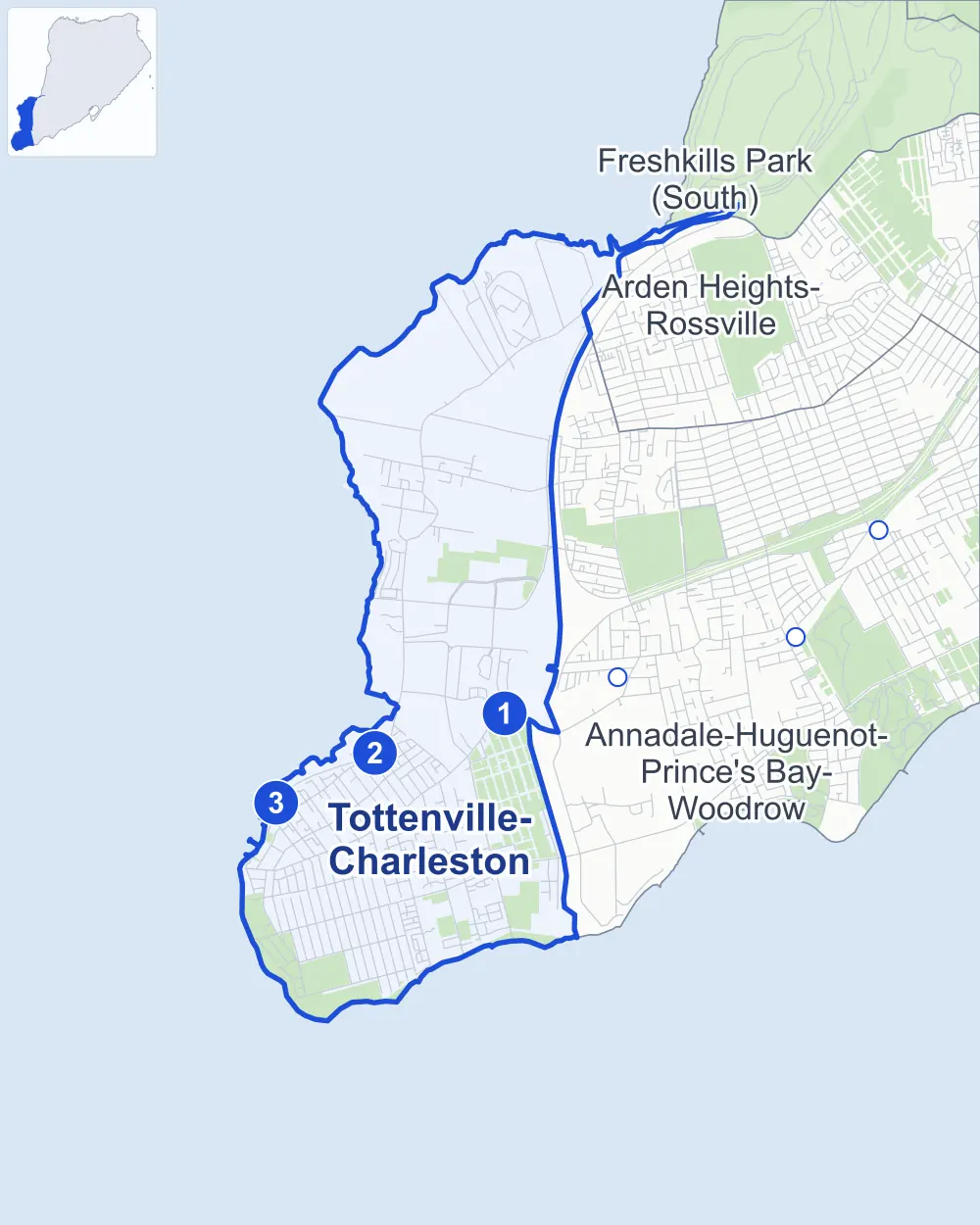
- Tottenville-Charleston
- A neighboring area
- Park
- A station in the list
- Another station
Neighborhood areas and streets: NYC Department of City Planning. Parks: NYC Parks. Stations: MTA.
Neighboring areas
- Arden Heights-Rossville northeast
- Freshkills Park (South) northeast
- Annadale-Huguenot-Prince's Bay-Woodrow east
Staten Island Railway stations
- Richmond Valley lines SIR
- Arthur Kill lines SIR accessible
- Tottenville lines SIR accessible
Getting around
The Staten Island Railway stops at Arthur Kill, Richmond Valley and Tottenville, and buses on 11 routes stop in or at the edge of Tottenville-Charleston.
- 3 Staten Island Railway stations
- 2 of them listed by the MTA as fully accessible
- 5 local bus routes
- 6 express bus routes
Local bus routes
- S55
- S59
- S74
- S78
- S84
Express bus routes
- SIM2
- SIM22
- SIM23
- SIM24
- SIM25
- SIM26
Safety record
Between 2021 and 2025, its corners averaged fewer police-reported crashes than the average Staten Island corner.
- 507 police-reported crashes at its corners
- 1.4 a corner, on average
- 2.2 the average Staten Island corner
- 216 corners with a clean record
Signal or safety changes on City record, at 17 of its corners
- Accessible pedestrian signals
- 17
- Leading pedestrian intervals
- 2
Camera tickets
In 2025 its corners had more school-zone speed camera tickets than red-light or bus-lane tickets.
- 0 red-light camera tickets
- 15,549 school-zone speed camera tickets at seven corners
- 0 bus-lane camera tickets
- Most speed tickets
- Hylan Boulevard & Culotta Lane, 9,886
People and homes
The 2020 Census counted 16,089 residents in Tottenville-Charleston, about 3,500 per square mile.
- 6,327 homes, 2020 Census
- 544 homes added since April 2010, net, by City Planning's count
Half of its 4,541 residential lots hold buildings from 1990 or earlier, and 25% of them date from before 1940, by the City's tax lot records.
Parks and landmarks
- Parkland
- 299.4 acres of NYC Parks property
- The largest pieces
- Conference House Park (151.2 acres), Long Pond Park (90 acres) and Fairview Park (43.9 acres)
- Designated landmarks
- The Rutan-Journeay House, the Westfield Township School No. 5, the New York Public Library's Tottenville Branch and the Free Magyar Reformed Church, among others
Streets and trees
- Trees
- 8,003 in NYC Parks' records, most often Callery pear, red maple and Japanese flowering cherry
- Street with the most corners
- Arthur Kill Road, with 45 of the area's 367
- Height above sea level
- From 7 feet at Arthur Kill Road & Nassau Place to 124 feet at Veterans Road West & Sharrotts Road
- Honorary street names
- 19 at its corners, enacted by local law
Schools and libraries
The City lists four schools and two libraries in Tottenville-Charleston.
- Public schools
- 3
- Charter or private school
- 1
- Libraries
- Charleston Library and Tottenville Library
Public safety
How complaints are countedIn 2025 the NYPD recorded 159 major felonies at places in Tottenville-Charleston.
Recorded by the NYPD at places in Tottenville-Charleston
- 130 major felonies in 2024
- 676 other felonies, misdemeanors and violations in 2025
- Police precinct
- 123rd
From January to June 2026 the NYPD recorded 75 major felonies at places in Tottenville-Charleston, against 82 in the same months of 2025.
Sources: the NYPD's Complaint Data Historic, updated April 28, 2026, and Complaint Data Current (Year To Date), updated July 27, 2026, on NYC Open Data. Figures to June 30, 2026.
Street corners
- Adlers Lane & Celina Lane
- Amaron Lane & Celina Lane
- Amaron Lane & Roman Court
- Amboy Road & Aspinwall Street
- Amboy Road & Aviva Court
- Amboy Road & Barnard Avenue
- Amboy Road & Bedell Avenue
- Amboy Road & Bentley Street
- Amboy Road & Bethel Avenue
- Amboy Road & Brehaut Avenue
- Amboy Road & Brighton Street
- Amboy Road & Butler Avenue
- Amboy Road & Carteret Street
- Amboy Road & Chelsea Street
- Amboy Road & Connecticut Street
- Amboy Road & Craig Avenue
- Amboy Road & Drew Court
- Amboy Road & Eugene Street
- Amboy Road & Finlay Street
- Amboy Road & Fisher Avenue
- Amboy Road & Hale Street
- Amboy Road & Hecker Street
- Amboy Road & Hopping Avenue
- Amboy Road & Johnson Avenue
- Amboy Road & Joline Avenue
- Amboy Road & Lee Avenue
- Amboy Road & Main Street
- Amboy Road & Murray Street
- Amboy Road & Nashville Street
- Amboy Road & Page Avenue
- Amboy Road & Parker Street
- Amboy Road & Richmond Valley Road (north-east)
- Amboy Road & Richmond Valley Road (south-west)
- Amboy Road & Satterlee Street
- Amboy Road & Sleight Avenue
- Amboy Road & Sprague Avenue
- Amboy Road & Swinnerton Street
- Amboy Road & Wood Avenue
- Amboy Road & Yetman Avenue
- Androvette Street & Manley Street
- Arthur Kill Road & Androvette Street
- Arthur Kill Road & Arthur Kill Correctional Facility Driveway
- Arthur Kill Road & Barnard Avenue
- Arthur Kill Road & Beirbower Lane
- Arthur Kill Road & Bentley Street
- Arthur Kill Road & Butler Avenue
- Arthur Kill Road & Chemical Lane
- Arthur Kill Road & Clay Pit Road
- Arthur Kill Road & Ellis Road
- Arthur Kill Road & Ellis Street
- Arthur Kill Road & Englewood Avenue
- Arthur Kill Road & Fisher Avenue
- Arthur Kill Road & Girard Street
- Arthur Kill Road & Grille Court
- Arthur Kill Road & Hervey Street
- Arthur Kill Road & Industrial Loop (north-east)
- Arthur Kill Road & Industrial Loop (south-west)
- Arthur Kill Road & Johnson Avenue
- Arthur Kill Road & Johnson Street
- Arthur Kill Road & Kreischer Street
- Arthur Kill Road & Lafayette Street
- Arthur Kill Road & Lee Avenue
- Arthur Kill Road & Main Street
- Arthur Kill Road & Manley Street
- Arthur Kill Road & Meagan Loop (north-east)
- Arthur Kill Road & Meagan Loop (south-west)
- Arthur Kill Road & Nassau Place
- Arthur Kill Road & North Bridge Street
- Arthur Kill Road & North Path
- Arthur Kill Road & Richmond Valley Road
- Arthur Kill Road & Sharrotts Road
- Arthur Kill Road & South Bridge Street
- Arthur Kill Road & St Andrews Place
- Arthur Kill Road & Storer Avenue
- Arthur Kill Road & Tides Lane
- Arthur Kill Road & Tiller Court
- Arthur Kill Road & Tracy Avenue
- Arthur Kill Road & Tyrrell Street
- Arthur Kill Road & Veterans Road West at Allentown Lane
- Arthur Kill Road & Winant Lane
- Arthur Kill Road & Winant Place
- Arthur Kill Road & Wood Avenue
- Arthur Kill Road & Wood Lane
- Arthur Kill Road & Yetman Avenue
- Aspinwall Street & Summit Road
- Bedell Avenue & Belvedere Court
- Bedell Avenue & Colita Court
- Bedell Avenue & Dell Court
- Bedell Avenue & Giegerich Avenue
- Bedell Avenue & Giegerich Place
- Bedell Avenue & Jacob Street
- Bedell Avenue & Jojo Court
- Bedell Avenue & Kerry Lane
- Bedell Avenue & Leonello Lane
- Bedell Avenue & Lerer Lane
- Bedell Avenue & Lulu Court
- Bedell Avenue & Newfolden Place
- Bedell Avenue & Nino Court
- Bedell Avenue & Ottavio Promenade
- Bedell Avenue & Poe Street
- Bedell Avenue & Spruce Court
- Bedell Avenue & Tucci Court
- Belwood Loop & Dintree Lane (east)
- Belwood Loop & Dintree Lane (west)
- Bentley Street & Earley Place
- Bentley Street & Hopping Avenue
- Bethel Avenue & Ferguson Court
- Bethel Avenue & Lenhart Street
- Bethel Avenue & Maiden Lane
- Bethel Avenue & Simon Court
- Bethel Avenue & St Andrews Place
- Billop Avenue & Brighton Street
- Billop Avenue & Chelsea Street
- Billop Avenue & Loretto Street
- Billop Avenue & Manhattan Street
- Billop Avenue & Rockaway Street
- Billop Avenue & Surf Avenue
- Bloomingdale Road & Westfield Avenue
- Boscombe Avenue & Madsen Avenue
- Boscombe Avenue & South Bridge Street
- Boscombe Avenue & Tyrellan Avenue
- Boscombe Avenue & Weiner Street
- Boscombe Avenue & West Shore Expressway
- Boscombe Avenue & West Shore Expressway (Exit 1)
- Brehaut Avenue & Truman Street
- Bricktown Way & Tyrellan Avenue
- Brighton Street & Pittsville Avenue
- Brighton Street & Summit Street
- Bruno Lane & Joline Lane
- Butler Avenue & Bentley Lane
- Butler Avenue & Lafayette Street
- Butler Boulevard & Faith Court
- Butler Boulevard & Flower Avenue
- Callahan Lane & Irene Lane
- Camden Avenue & Camden Court
- Canter Avenue & Federal Court
- Carteret Street & Pittsville Avenue
- Chart Loop & Tides Lane
- Chelsea Street & Pittsville Avenue
- Clermont Avenue & Aspinwall Street
- Clermont Avenue & Belwood Loop (east)
- Clermont Avenue & Belwood Loop (west)
- Clermont Avenue & Brighton Street
- Clermont Avenue & Carteret Street
- Clermont Avenue & Chelsea Street
- Clermont Avenue & Connecticut Street
- Clermont Avenue & Finlay Street
- Clermont Avenue & Loretto Street
- Clermont Avenue & Manhattan Street
- Clermont Avenue & Massachusetts Street South
- Clermont Avenue & Rockaway Street
- Clermont Avenue & Swinnerton Street
- Connecticut Street & Summit Road
- Craig Avenue & Barnard Avenue
- Craig Avenue & Bentley Street
- Craig Avenue & Bethel Avenue
- Craig Avenue & Bocce Court
- Craig Avenue & Brehaut Avenue
- Craig Avenue & Butler Avenue
- Craig Avenue & Clermont Avenue
- Craig Avenue & Federal Court
- Craig Avenue & Fisher Avenue
- Craig Avenue & Hecker Street
- Craig Avenue & Johnson Avenue
- Craig Avenue & Lee Avenue
- Craig Avenue & Lion Street
- Craig Avenue & Main Street
- Craig Avenue & Nashville Street
- Craig Avenue & Patten Street
- Craig Avenue & Satterlee Street
- Craig Avenue & Shore Road
- Craig Avenue & Summit Road
- Craig Avenue & Wood Avenue
- Craig Avenue & Yetman Avenue
- Dintree Lane & Belvedere Court
- Ellis Street & Weir Lane
- Englewood Avenue & Gaton Street
- Eugene Street & Camden Avenue
- Finlay Street & Summit Road
- Fisher Avenue & Joseph Court
- Fisher Avenue & Orchard Avenue
- George Street & Delia Court
- Giegerich Avenue & Cheevers Lane
- Haywood Street & Jacob Street
- Haywood Street & Jeffrey Place
- Hecker Street & Lenhart Street
- Hecker Street & Maiden Lane
- Hecker Street & St Andrews Place
- Honey Lane & Blossom Lane
- Hopping Avenue & Patten Street
- Hylan Boulevard & Aspinwall Street
- Hylan Boulevard & Bedell Avenue
- Hylan Boulevard & Brighton Street
- Hylan Boulevard & Butler Boulevard
- Hylan Boulevard & Canter Avenue
- Hylan Boulevard & Carteret Street
- Hylan Boulevard & Chelsea Street
- Hylan Boulevard & Connecticut Street
- Hylan Boulevard & Craig Avenue
- Hylan Boulevard & Culotta Lane
- Hylan Boulevard & Finlay Street
- Hylan Boulevard & Joline Avenue
- Hylan Boulevard & Loretto Street
- Hylan Boulevard & Main Street
- Hylan Boulevard & Manhattan Street
- Hylan Boulevard & Massachusetts Street South
- Hylan Boulevard & Page Avenue
- Hylan Boulevard & Richard Avenue
- Hylan Boulevard & Rockaway Street
- Hylan Boulevard & Satterlee Street
- Hylan Boulevard & Sleight Avenue
- Hylan Boulevard & Sprague Avenue
- Hylan Boulevard & Swinnerton Street
- Hylan Boulevard & Wards Point Avenue
- Hylan Boulevard & Yetman Avenue
- Industrial Loop & Derick Court
- Industrial Loop & Zarelli Court
- Joline Avenue & Adlers Lane
- Joline Avenue & Amaron Lane
- Joline Avenue & Blossom Lane
- Joline Avenue & Bruno Lane
- Joline Avenue & Emily Court
- Joline Avenue & Giegerich Place
- Joline Avenue & Honey Lane
- Joline Avenue & Jacob Street
- Joline Avenue & Joline Lane
- Joline Avenue & Kathleen Court
- Joline Avenue & Poe Street
- Joline Avenue & Sylvan Court
- Joline Avenue & Tricia Way
- Joline Avenue & Truman Street
- Joyce Lane & Keppel Avenue
- Korean War Vets Parkway & West Shore Expressway
- Kreischer Street & Androvette Street
- Kreischer Street & Winant Place
- Lafayette Street & Earley Place
- Lenhart Street & Hale Street
- Lenhart Street & Parker Street
- Lerer Lane & Callahan Lane
- Lerer Lane & Irene Lane
- Lerer Lane & Jayne Lane
- Loretto Street & Forest Lane
- Loretto Street & Sandy Lane
- Loretto Street & Sea Crest Lane
- Loretto Street & Surf Avenue
- Loretto Street & Wildwood Lane
- Lundsten Avenue & Carlin Street
- Maiden Lane & Hart Place
- Maiden Lane & Lion Street
- Main Street & Bentley Lane
- Main Street & Billop Avenue
- Main Street & Clermont Avenue
- Main Street & Conference Court
- Main Street & Eden Court
- Main Street & Ellis Street
- Main Street & Pittsville Avenue
- Main Street & Utah Street
- Manhattan Street & Pittsville Avenue
- Meade Loop & Butler Street
- Moon Avenue & McDonald Court
- Moon Avenue & Nichols Court
- Nashville Street & Lenhart Street
- Nassau Place & Averill Place
- North Bridge Street & Outerbridge Avenue
- North Bridge Street & West Shore Parkway
- Ottavio Promenade & Leonello Lane
- Outerbridge Crossing & Arthur Kill Road
- Page Avenue & Academy Avenue
- Page Avenue & Adelphi Avenue
- Page Avenue & Bartow Avenue
- Page Avenue & Camden Avenue
- Page Avenue & Clermont Avenue
- Page Avenue & Dawn Court
- Page Avenue & Eastwood Avenue
- Page Avenue & Estelle Place
- Page Avenue & Haywood Street
- Page Avenue & Jeffrey Place
- Page Avenue & Lerer Lane
- Page Avenue & Minerva Avenue
- Page Avenue & Ottavio Promenade
- Page Avenue & Richmond Valley Road
- Perth Amboy Place & Wards Point Avenue
- Pilot Lane & Chart Loop
- Pilot Lane & Tiller Court
- Poe Street & Poe Court
- Richard Avenue & Bartow Avenue
- Richard Avenue & Flower Avenue
- Richmond Valley Road & Frosinone Lane
- Richmond Valley Road & Madsen Avenue
- Richmond Valley Road & Torrice Loop (east)
- Richmond Valley Road & Torrice Loop (west)
- Richmond Valley Road & Weiner Street
- Satterlee Street & Perth Amboy Place
- Satterlee Street & Tottenville Place
- Sharrotts Road & Brick Court
- Sharrotts Road & Brienna Court
- Sharrotts Road & Carlin Street
- Sharrotts Road & Kent Street
- Sharrotts Road & Marjorie Street
- Sharrotts Road & Muriel Street
- Sharrotts Road & Trioka Way
- Shore Road & Aspinwall Street
- Shore Road & Bryan Street
- Shore Road & Connecticut Street
- Shore Road & Finlay Street
- Shore Road & Satterlee Street
- Sleight Avenue & George Street
- Sleight Avenue & Paradise Place
- Sprague Avenue & Forest Lane
- Sprague Avenue & George Street
- Sprague Avenue & Joyce Lane
- Sprague Avenue & Nancy Lane
- Sprague Avenue & Nancy Lane at Keppel Avenue
- Sprague Avenue & Petunia Court
- Sprague Avenue & Sandy Lane
- Sprague Avenue & Sanford Street
- Sprague Avenue & Sea Breeze Lane
- Sprague Avenue & Sea Crest Lane
- Sprague Avenue & Sprague Court
- Sprague Avenue & Sunset Lane
- Sprague Avenue & Surf Avenue
- Sprague Avenue & Wildwood Lane
- Sprague Avenue & Winding Woods Loop (north)
- Sprague Avenue & Winding Woods Loop (south)
- St Andrews Place & Hart Place
- Storer Avenue & Carlin Street
- Summit Road & Bryan Street
- Sunset Lane & Sea Crest Lane
- Surf Avenue & McDonald Court
- Surf Avenue & Nichols Court
- Surfside Plaza & Sea Breeze Lane
- Swinnerton Street & Billop Avenue
- Swinnerton Street & Pittsville Avenue
- Sylvan Court & Kathleen Court
- Sylvan Court & Kerry Lane
- Topside Lane & Tides Lane
- Topside Lane & Tiller Court
- Torrice Loop & Frosinone Lane
- Tottenville Place & Wards Point Avenue
- Tyrrell Street & Utah Street
- Veterans Road West & Bloomingdale Road
- Veterans Road West & Bricktown Way (east)
- Veterans Road West & Bricktown Way (west)
- Veterans Road West & Clay Pit Road
- Veterans Road West & Englewood Avenue
- Veterans Road West & Sharrotts Road
- Veterans Road West & Tyrellan Avenue
- Veterans Road West & West Shore Expressway
- Veterans Road West & West Shore Expressway (Exit 1)
- Veterans Road West & West Shore Expressway (Exit 3A)
- Veterans Road West & West Shore Parkway
- Weiner Street & Butler Street
- Weiner Street & Cole Street
- Weiner Street & Meade Loop
- Weiner Street & Richmond Place
- West Shore Expressway & Tyrellan Avenue
- West Shore Expressway & West Shore Parkway
- Wildwood Lane & Sandy Lane
- Winant Place & Marble Loop
- Winant Place & Trioka Way
- Winding Woods Loop & Surfside Plaza (north-west)
- Winding Woods Loop & Surfside Plaza (south-east)
- Yetman Avenue & Academy Avenue
- Yetman Avenue & Billop Avenue
- Yetman Avenue & Clermont Avenue
- Yetman Avenue & Pittsville Avenue
- Yetman Avenue & Summit Street
How the figures above are measured: Methodology.