Arden Heights-Rossville
Neighborhood · Staten Island
Arden Heights-Rossville spreads across Staten Island's South Shore toward the Arthur Kill, taking in Arden Heights, Rossville, Woodrow and the historic community of Sandy Ground.
- 2.43 square miles
- 30,683 residents, 2020 Census
- 356 street corners
- 13 bus routes
Rossville was called Blazing Star in the mid-1700s, after a tavern, and its ferry crossed to New Jersey; renamed for William E. Ross by the 1830s, it keeps the Blazing Star Burial Ground, one of the island's earliest community cemeteries, with gravestones from 1750. Sandy Ground, where free African Americans bought land starting in 1828 and worked in the oyster trade, is among the nation's oldest such communities, and Woodrow's plain Greek Revival Methodist church dates from 1842.
Sources: Sleight Family Graveyard (The Rossville (Blazing Star) Burial Ground) Designation Report (LP-0387, January 17, 1968) (NYC Landmarks Preservation Commission); Woodrow Methodist Church Designation Report (LP-0385, November 15, 1967) (NYC Landmarks Preservation Commission); Rossville, Staten Island (Wikipedia).
Arden Heights-Rossville borders five areas, and Woodrow Road holds more of its corners than any other street, 35 of 356.
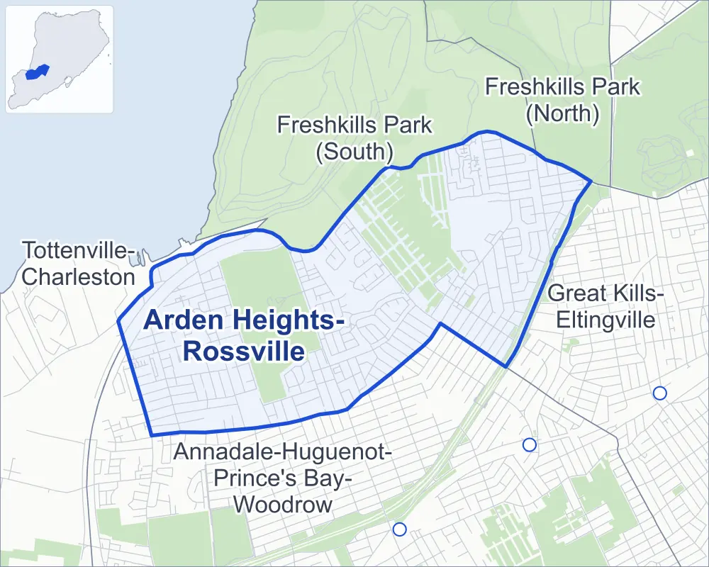
- Arden Heights-Rossville
- A neighboring area
- Park
- Another station
Neighborhood areas and streets: NYC Department of City Planning. Parks: NYC Parks. Stations: MTA.
Neighboring areas
- Freshkills Park (South) north
- Freshkills Park (North) northeast
- Great Kills-Eltingville east
- Annadale-Huguenot-Prince's Bay-Woodrow southwest
- Tottenville-Charleston west
Getting around
Buses on 13 routes stop in or at the edge of Arden Heights-Rossville.
- 4 local bus routes
- 9 express bus routes
Local bus routes
- S55
- S56
- S74
- S84
Express bus routes
- SIM2
- SIM4
- SIM4C
- SIM8
- SIM22
- SIM23
- SIM24
- SIM25
- SIM26
Safety record
Between 2021 and 2025, its corners averaged fewer police-reported crashes than the average Staten Island corner.
- 497 police-reported crashes at its corners
- 1.4 a corner, on average
- 2.2 the average Staten Island corner
- 192 corners with a clean record
Signal or safety changes on City record, at 25 of its corners
- Accessible pedestrian signals
- 24
- Leading pedestrian intervals
- 5
- Turn calming
- 1
Camera tickets
In 2025 its corners had more school-zone speed camera tickets than red-light or bus-lane tickets.
- 0 red-light camera tickets
- 3,480 school-zone speed camera tickets at six corners
- 0 bus-lane camera tickets
- Most speed tickets
- Bloomingdale Road & Shiel Avenue, 1,791
People and homes
The 2020 Census counted 30,683 residents in Arden Heights-Rossville, about 12,600 per square mile.
- 11,193 homes, 2020 Census
- 412 homes added since April 2010, net, by City Planning's count
Half of its 8,183 residential lots hold buildings from 1987 or earlier, and 1% of them date from before 1940, by the City's tax lot records.
Parks and landmarks
- Parkland
- 146.1 acres of Arden Woods, as NYC Parks maps it within Arden Heights-Rossville
- Designated landmark
- The Woodrow United Methodist Church
Streets and trees
- Trees
- 8,175 in NYC Parks' records, most often Callery pear, red maple and sweetgum
- Street with the most corners
- Woodrow Road, with 35 of the area's 356
- Height above sea level
- From 8 feet at Arthur Kill Road & Rossville Avenue to 153 feet at Powell Street & Shift Place
- Honorary street names
- 11 at its corners, enacted by local law
Schools
The City lists four schools in Arden Heights-Rossville.
- Public schools
- 4
Public art
The City's public art inventory lists one work in Arden Heights-Rossville: Working in the Same Direction (2003).
- 1 work of public art
Public safety
How complaints are countedIn 2025 the NYPD recorded 113 major felonies at places in Arden Heights-Rossville.
Recorded by the NYPD at places in Arden Heights-Rossville
- 95 major felonies in 2024
- 463 other felonies, misdemeanors and violations in 2025
In 2025, on the streets along the edge of Arden Heights-Rossville, the NYPD recorded another 11 major felonies. Counting the streets along its edge, in 2025 the NYPD recorded 4.0 major felonies for every thousand residents the 2020 Census counted in Arden Heights-Rossville.
- Police precinct
- 123rd
From January to June 2026 the NYPD recorded 61 major felonies at places in Arden Heights-Rossville, against 54 in the same months of 2025.
Sources: the NYPD's Complaint Data Historic, updated April 28, 2026, and Complaint Data Current (Year To Date), updated July 27, 2026, on NYC Open Data. Figures to June 30, 2026.
Street corners
- Aaron Lane & Samantha Lane
- Alexander Avenue & Ibsen Avenue
- Alexander Avenue & Loring Avenue
- Alexander Avenue & Von Braun Avenue
- Alverson Avenue & Aaron Lane
- Alverson Avenue & Alverson Loop
- Alverson Avenue & Balsam Place
- Alverson Avenue & Barrow Place
- Alverson Avenue & Correll Avenue
- Alverson Avenue & Grafe Street
- Alverson Avenue & Gunton Place
- Alverson Avenue & Morris Street
- Alverson Avenue & Pond Street
- Alverson Avenue & Selkirk Street
- Alverson Avenue & West Castor Place
- Anaconda Street & Sperry Place
- Annadale Road & Berry Avenue
- Annadale Road & Crossfield Avenue
- Annadale Road & Don Court
- Annadale Road & Dorval Avenue
- Annadale Road & Forrestal Avenue
- Annadale Road & Ladd Avenue
- Annadale Road & Token Street
- Annadale Road & Tynan Street
- Annadale Road & Watkins Avenue
- Arden Avenue & Correll Avenue
- Arden Avenue & Crown Avenue
- Arden Avenue & Dover Green
- Arden Avenue & Forest Green
- Arden Avenue & Halpin Avenue
- Arden Avenue & Hampton Green
- Arden Avenue & Nedra Lane
- Arden Avenue & Rathbun Avenue
- Arden Avenue & Rensselaer Avenue
- Arden Avenue & Rolling Hill Green
- Arden Avenue & Sheldon Avenue
- Arden Avenue & Stafford Avenue
- Arden Avenue & Vespa Avenue
- Arden Avenue & Vineland Avenue
- Arrowood Court & Berry Court
- Arrowood Court & Larch Court
- Arrowood Court & Wood Court
- Arthur Kill Road & Annadale Road
- Arthur Kill Road & Arden Avenue
- Arthur Kill Road & Aspen Knolls Way
- Arthur Kill Road & Bloomingdale Road
- Arthur Kill Road & Carlyle Green
- Arthur Kill Road & Cody Place
- Arthur Kill Road & Crossfield Avenue
- Arthur Kill Road & Engert Street
- Arthur Kill Road & Futurity Place
- Arthur Kill Road & Huguenot Avenue
- Arthur Kill Road & Ilyssa Way
- Arthur Kill Road & Kenilworth Avenue
- Arthur Kill Road & Krissa Court
- Arthur Kill Road & Ladd Avenue
- Arthur Kill Road & Mazza Court
- Arthur Kill Road & Muldoon Avenue
- Arthur Kill Road & Rossville Avenue
- Arthur Kill Road & St Lukes Avenue
- Arthur Kill Road & Token Street
- Arthur Kill Road & Veterans Road East
- Arthur Kill Road & Veterans Road West
- Arthur Kill Road & Veterans Road West at West Service Road
- Arthur Kill Road & Woodrow Road
- Arthur Kill Road & Zebra Place
- Ashley Lane & Sandywood Lane (north)
- Ashley Lane & Sandywood Lane (south)
- Ashton Drive & Mimosa Lane
- Aspen Knolls Way & Amanda Court
- Aspen Knolls Way & Bianca Court
- Aspen Knolls Way & Ilyssa Way
- Aspen Knolls Way & Jamie Lane
- Balsam Place & Arrowood Court
- Balsam Place & Hampton Place
- Barry Street & Bar Court
- Barry Street & Iris Court
- Barry Street & Rutherford Court
- Belfield Avenue & Rosedale Avenue
- Bloomingdale Road & Crabtree Lane
- Bloomingdale Road & Harris Lane
- Bloomingdale Road & Kramer Avenue
- Bloomingdale Road & Lorraine Loop
- Bloomingdale Road & Prince Lane
- Bloomingdale Road & Shiel Avenue
- Bloomingdale Road & Wirt Avenue
- Boulder Street & Bouton Lane
- Boulder Street & Castor Place
- Bunnell Court & Alcott Street
- Bunnell Court & Lombard Court
- Candon Avenue & Candon Court
- Candon Avenue & Phyllis Court
- Candon Avenue & Prince Lane
- Candon Avenue & Wirt Lane
- Carlton Boulevard & Crown Avenue
- Carlton Boulevard & Crown Court
- Carlton Boulevard & Deborah Loop
- Carlton Boulevard & Halpin Avenue
- Carlton Boulevard & Vineland Avenue
- Carlyle Green & Poets Circle
- Castor Place & Anaconda Street
- Castor Place & Cardiff Street
- Charleston Avenue & Hampton Place
- Charleston Avenue & Hemlock Court
- Charleston Avenue & Hickory Court
- Cody Place & Country Lane
- Cody Place & Lombard Court
- Cody Place & Pratt Court
- Correll Avenue & Ashley Lane
- Correll Avenue & Bombay Street
- Correll Avenue & Edo Court
- Correll Avenue & Gervil Street
- Correll Avenue & Hemlock Street
- Correll Avenue & Mallow Street
- Correll Avenue & Winant Avenue
- Country Lane & Pratt Court
- Coventry Loop & Cardiff Street
- Covington Circle & Wycliff Lane (north-west)
- Covington Circle & Wycliff Lane (south-east)
- Crossfield Avenue & Berry Avenue
- Crossfield Avenue & Dorval Avenue
- Crossfield Avenue & Ladd Avenue
- Crossfield Avenue & Token Street
- Crossfield Avenue & Watkins Avenue
- Crown Avenue & Crown Court
- Crown Avenue & Deborah Loop
- Crown Avenue & Evan Place
- Crown Avenue & Grantwood Avenue
- Crown Avenue & Row Place
- Dahlia Street & Rumba Place
- Dahlia Street & Shift Place
- Delmar Avenue & Anaconda Street
- Delmar Avenue & Sperry Place
- Dogwood Drive & Ashton Drive
- Dogwood Drive & Maple Court
- Dogwood Drive & Mimosa Lane
- Dogwood Drive & Yucca Drive
- Dover Green & Chestnut Circle
- Dover Green & Kyle Court
- Drumgoole Road West & Annadale Road
- Drumgoole Road West & Arden Avenue
- Drumgoole Road West & Carlton Boulevard
- Drumgoole Road West & Dorval Avenue
- Drumgoole Road West & Grantwood Avenue
- Drumgoole Road West & Korean Vets Parkway
- Drumgoole Road West & Notus Avenue
- Drumgoole Road West & Smyrna Avenue
- Drumgoole Road West & Van Allen Avenue
- Drumgoole Road West & Walker Court
- Everton Avenue & Sperry Place
- Forest Green & Birch Lane
- Gervil Street & Balsam Place
- Gervil Street & Locust Court
- Gold Avenue & Berry Avenue West
- Gold Avenue & Cheryl Avenue
- Grafe Street & Arrowood Court
- Grafe Street & Azalea Court
- Grafe Street & Hampton Place
- Grafe Street & Totten Street
- Grantwood Avenue & Tryon Avenue
- Green Valley Road & Manchester Drive (east)
- Green Valley Road & Manchester Drive (west)
- Green Valley Road & Victoria Road
- Gunton Place & Totten Street
- Halpin Avenue & Linda Lane
- Halpin Avenue & Regina Lane
- Hammock Lane & Geyser Drive
- Hampton Green & Barclay Circle
- Hampton Green & Beekman Circle
- Hampton Green & Princeton Lane
- Hampton Green & Regent Circle
- Hampton Place & Cypress Loop
- Hampton Place & Meadow Court
- Huguenot Avenue & Avon Green
- Huguenot Avenue & Castor Place
- Huguenot Avenue & Lombard Court
- Huguenot Avenue & Rosedale Avenue
- Huguenot Avenue & Rumba Place
- Huguenot Avenue & Shift Place
- Huguenot Avenue & Sussex Green
- Ilyssa Way & Emily Lane
- Ilyssa Way & Jamie Lane
- Jamie Lane & Emily Lane
- Jefferson Boulevard & Vespa Avenue
- Kenilworth Avenue & Benson Street
- Kenilworth Avenue & Billings Street
- Kenilworth Avenue & Chatham Street
- Kenilworth Avenue & Gary Street
- Kenilworth Avenue & Hinton Street
- Kenilworth Avenue & Winston Street
- Kenmore Street & Dierauf Street
- Kenmore Street & Tynan Street
- Korean War Vets Parkway & Arden Avenue
- Ladd Avenue & Alexandra Court
- Ladd Avenue & Challenger Drive
- Legate Avenue & Linda Lane
- Lisa Lane & Ebey Lane
- Lisa Lane & Myrna Lane
- Locust Court & Acorn Court
- Lombard Court & Country Lane
- Loring Avenue & Forrestal Court
- Ludlow Street & Walker Court
- Maguire Avenue & Correll Avenue
- Maguire Avenue & Mason Boulevard
- Maguire Avenue & McBaine Avenue
- Mallow Street & Barrow Place
- Manchester Drive & Victoria Road
- Marcy Avenue & Venus Place
- Marcy Avenue & West Castor Place
- Mason Boulevard & Bombay Street
- Mason Boulevard & Gervil Street
- Mason Boulevard & Hemlock Street
- Mason Boulevard & Mallow Street
- McArthur Avenue & Forrestal Avenue
- McArthur Avenue & Loring Avenue
- McArthur Avenue & Ludlow Street
- McArthur Avenue & Van Allen Avenue
- Mimosa Lane & Yucca Drive
- Morris Street & Samantha Lane
- Myrna Lane & Ebey Lane
- Powell Street & Powell Lane
- Powell Street & Shift Place
- Powell Street & Venus Place
- Powell Street & West Castor Place
- Radigan Avenue & Bombay Street
- Raily Court & Alcott Street
- Rathbun Avenue & Carlton Boulevard
- Rathbun Avenue & Grantwood Avenue
- Redwood Loop & Balsam Place
- Rensselaer Avenue & Carlton Boulevard
- Rensselaer Avenue & Grantwood Avenue
- Rolling Hill Green & Hickory Circle
- Rolling Hill Green & Sutton Place
- Rolling Hill Green & Tulip Circle
- Rosedale Avenue & Anaconda Street
- Rosedale Avenue & Boulder Street
- Rosedale Avenue & Cardiff Street
- Rosedale Avenue & Dahlia Street
- Rosedale Avenue & Everton Avenue
- Rosedale Avenue & Powell Street
- Rosedale Avenue & Vespa Avenue
- Rossville Avenue & Aaron Lane
- Rossville Avenue & Balsam Place
- Rossville Avenue & Barrow Place
- Rossville Avenue & Barry Street
- Rossville Avenue & Berry Court
- Rossville Avenue & Correll Avenue
- Rossville Avenue & Grafe Street
- Rossville Avenue & Gunton Place
- Rossville Avenue & Knesel Street
- Rossville Avenue & Larch Court
- Rossville Avenue & Locust Court
- Rossville Avenue & Mason Boulevard
- Rossville Avenue & McBaine Avenue
- Rossville Avenue & Morris Street
- Rossville Avenue & Poplar Avenue
- Rossville Avenue & Selkirk Street
- Rossville Avenue & Wood Court
- Russek Drive & Avon Green
- Russek Drive & Dogwood Drive
- Russek Drive & Geyser Drive
- Russek Drive & Sussex Green
- Sheldon Avenue & Carlton Boulevard
- Sheldon Avenue & Grantwood Avenue
- Shiel Avenue & Bombay Street
- Shotwell Avenue & Smyrna Avenue
- Shotwell Avenue & Tryon Avenue
- Shotwell Avenue & Waring Avenue
- Sinclair Avenue & Carlton Boulevard
- Sinclair Avenue & Grantwood Avenue
- Sperry Place & Ballard Avenue
- St Lukes Avenue & Hervey Street
- Stack Drive & Hammock Lane
- Stack Drive & Myrna Lane
- Stafford Avenue & Carlton Boulevard
- Stafford Avenue & Grantwood Avenue
- Sunfield Avenue & Cheryl Avenue
- Sunfield Avenue & Dorval Place
- Token Street & Futurity Place
- Vespa Avenue & Almond Street
- Vespa Avenue & Canton Avenue
- Vespa Avenue & Manchester Drive
- Vespa Avenue & Ruxton Avenue
- Veterans Road East & Kunath Avenue
- Veterans Road East & Poplar Avenue
- Veterans Road East & Rossville Avenue
- Veterans Road East & West Shore Expressway
- Veterans Road East & Winant Avenue
- Veterans Road West & Engert Street
- Veterans Road West & Hervey Street
- Veterans Road West & Rossville Avenue
- Veterans Road West & West Shore Expressway
- Veterans Road West & West Shore Expressway (Exit 3)
- Veterans Road West & Zebra Place
- Vineland Avenue & Grantwood Avenue
- West Castor Place & Alverson Loop
- West Castor Place & Gilroy Street
- West Castor Place & Wycliff Lane
- West Shore Expressway & Arthur Kill Road
- West Shore Expressway & Rossville Avenue
- Winant Avenue & Charleston Avenue
- Winant Avenue & Kramer Avenue
- Winant Avenue & Lucille Avenue
- Winant Avenue & Mason Boulevard
- Winant Avenue & McBaine Avenue
- Winant Avenue & Millennium Loop
- Winant Avenue & Radigan Avenue
- Winant Avenue & Shiel Avenue
- Winant Avenue & Westfield Avenue
- Winant Avenue & Wirt Avenue
- Wirt Avenue & Ashley Lane
- Wirt Avenue & Hampton Place
- Wirt Avenue & Redwood Loop
- Wirt Avenue & Wirt Lane
- Woehrle Avenue & Alexander Avenue
- Woehrle Avenue & Ibsen Avenue
- Woehrle Avenue & Loring Avenue
- Woehrle Avenue & Ludlow Street
- Woehrle Avenue & Notus Avenue
- Woehrle Avenue & Smyrna Avenue
- Woehrle Avenue & Von Braun Avenue
- Woehrle Avenue & Waring Avenue
- Woodrow Road & Alexander Avenue
- Woodrow Road & Alverson Avenue
- Woodrow Road & Arden Avenue
- Woodrow Road & Ballard Avenue
- Woodrow Road & Belfield Avenue
- Woodrow Road & Benson Street
- Woodrow Road & Berry Avenue West
- Woodrow Road & Boulder Street
- Woodrow Road & Boylan Street
- Woodrow Road & Carlton Boulevard
- Woodrow Road & Dahlia Street
- Woodrow Road & Delmar Avenue
- Woodrow Road & Dexter Avenue
- Woodrow Road & Dierauf Street
- Woodrow Road & Evan Place
- Woodrow Road & Everton Avenue
- Woodrow Road & Gilroy Street
- Woodrow Road & Heffernan Street
- Woodrow Road & Hinton Street
- Woodrow Road & Ilyssa Way
- Woodrow Road & Kenmore Street
- Woodrow Road & Lenevar Avenue
- Woodrow Road & Lynbrook Avenue
- Woodrow Road & Maguire Avenue
- Woodrow Road & Marcy Avenue
- Woodrow Road & Powell Street
- Woodrow Road & Presentation Circle
- Woodrow Road & Regina Lane
- Woodrow Road & Rossville Avenue
- Woodrow Road & Row Place
- Woodrow Road & Shotwell Avenue
- Woodrow Road & Susanna Lane
- Woodrow Road & Tynan Street
- Woodrow Road & Vineland Avenue
How the figures above are measured: Methodology.