Brooklyn
More people live in Brooklyn than in any other borough.
- 10,401 street corners
- 53 residential neighborhoods
- 69.4 square miles of land
- 2,653,963 residents Census Bureau estimate, July 1, 2025
It began as the Dutch town of Breuckelen and was an independent city until it joined Greater New York in 1898.
Neighborhoods
Open the map full sizeBrooklyn's street corners fall into 66 of City Planning's neighborhood areas, from Greenpoint in the north to Coney Island-Sea Gate on the Atlantic shore.
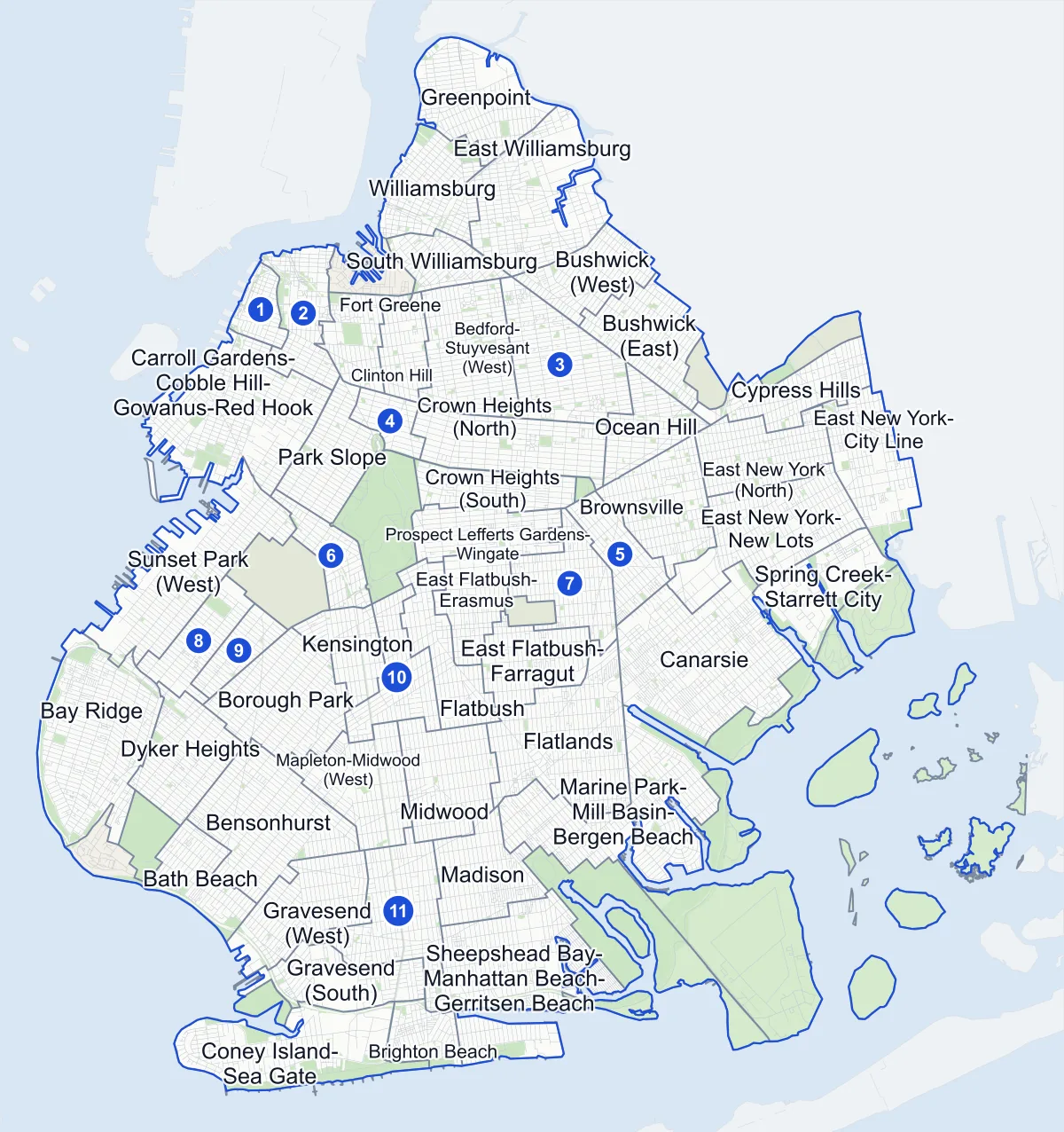
- Neighborhood
- Park
- Cemetery
- Other area
- Another borough
- Name in the list
Neighborhood areas and streets: NYC Department of City Planning. Parks: NYC Parks.
Residential neighborhoods
- Bath Beach 120 corners
- Bay Ridge 384 corners
- Bedford-Stuyvesant (East) 218 corners
- Bedford-Stuyvesant (West) 191 corners
- Bensonhurst 282 corners
- Borough Park 259 corners
- Brighton Beach 170 corners
- Brooklyn Heights 112 corners
- Brownsville 200 corners
- Bushwick (East) 178 corners
- Bushwick (West) 180 corners
- Canarsie 439 corners
- Carroll Gardens-Cobble Hill-Gowanus-Red Hook 403 corners
- Clinton Hill 89 corners
- Coney Island-Sea Gate 194 corners
- Crown Heights (North) 165 corners
- Crown Heights (South) 106 corners
- Cypress Hills 193 corners
- Downtown Brooklyn-DUMBO-Boerum Hill 219 corners
- Dyker Heights 169 corners
- East Flatbush-Erasmus 126 corners
- East Flatbush-Farragut 126 corners
- East Flatbush-Remsen Village 122 corners
- East Flatbush-Rugby 183 corners
- East New York (North) 204 corners
- East New York-City Line 184 corners
- East New York-New Lots 243 corners
- East Williamsburg 377 corners
- Flatbush 150 corners
- Flatbush (West)-Ditmas Park-Parkville 154 corners
- Flatlands 332 corners
- Fort Greene 118 corners
- Gravesend (East)-Homecrest 222 corners
- Gravesend (South) 134 corners
- Gravesend (West) 211 corners
- Greenpoint 212 corners
- Kensington 95 corners
- Madison 154 corners
- Mapleton-Midwood (West) 143 corners
- Marine Park-Mill Basin-Bergen Beach 343 corners
- Midwood 162 corners
- Ocean Hill 149 corners
- Park Slope 169 corners
- Prospect Heights 54 corners
- Prospect Lefferts Gardens-Wingate 125 corners
- Sheepshead Bay-Manhattan Beach-Gerritsen Beach 461 corners
- South Williamsburg 151 corners
- Spring Creek-Starrett City 61 corners
- Sunset Park (Central) 89 corners
- Sunset Park (East)-Borough Park (West) 68 corners
- Sunset Park (West) 215 corners
- Williamsburg 281 corners
- Windsor Terrace-South Slope 125 corners
Parks and other areas
nine areas
- Barren Island-Floyd Bennett Field five corners
- Brooklyn Navy Yard 67 corners
- Canarsie Park & Pier five corners
- Dyker Beach Park two corners
- Fort Hamilton 45 corners
- Marine Park-Plumb Island three corners
- McGuire Fields one corner
- Prospect Park 21 corners
- Shirley Chisholm State Park 15 corners
Areas drawn in Queens
four areas
City Planning draws these areas in Queens, but some of their street corners are in Brooklyn.
- Howard Beach-Lindenwood three corners
- Ozone Park four corners
- Ridgewood 14 corners
- Woodhaven two corners
Getting around
Brooklyn has more subway station complexes inside its borders than any other borough.
- 156 subway station complexes
- 18 subway lines
- 78 bus routes with stops in Brooklyn
Safety record
Brooklyn has more leading pedestrian intervals than any other borough: signals that give people on foot a head start before cars move.
- 109,027 police-reported crashes between 2021 and 2025
- 7 crash count at the median corner
- 2,561 corners with a leading pedestrian interval
- 3,208 corners with a signal or safety change of any kind
Public safety
How complaints are countedIn Brooklyn's precincts the NYPD recorded 31,032 major felonies during 2025, excluding complaints in the Department of Correction's jurisdiction.
Camera tickets
Brooklyn had more red-light camera tickets in 2025 than any other borough.
- 211,461 red-light camera tickets at 71 corners on the list
- 1,076,692 school-zone speed camera tickets at 627 corners on the list
- 119,826 bus-lane camera tickets at 44 corners on the list
Of Brooklyn's corners on the red-light list, Ocean Parkway & Avenue I had the most tickets, 14,477.
Brooklyn's corners on the city-wide camera-ticket lists: Red-light camera tickets · School-zone speed camera tickets · Bus-lane camera tickets
Homes, parks and landmarks
Brooklyn has added more homes since April 2010 than any other borough, by City Planning's Housing Database.
- 155,926 homes added, net, since April 2010
- 582 parks
- 237,400 trees in NYC Parks' records
- 41 historic districts Second to Manhattan's 59
Of the borough's parks, Marine Park and Prospect Park cover the most ground.
Elevation
Brooklyn's corners rise from 3 feet to 181 feet above sea level.
- Highest
- Prospect Park West & 18th Street, in Windsor Terrace-South Slope
- Lowest
- four corners tie, among them Stanton Road & Losee Terrace in Sheepshead Bay-Manhattan Beach-Gerritsen Beach
Streets
There are 1,660 streets in Brooklyn with two or more intersections, each listing its corners in order along the road.
Questions about Brooklyn
How many intersections are in Brooklyn? There are 10,401 street corners in Brooklyn by this site's count, and every one has its own page.
Which Brooklyn neighborhood has the most street corners? Sheepshead Bay-Manhattan Beach-Gerritsen Beach, with 461.
How many people live in Brooklyn? About 2.65 million, down from 2,736,074 at the 2020 Census.
Sources: Kings (The State of New York); New York City: The boroughs (Encyclopaedia Britannica); Traffic Signals (NYC Department of Transportation).