Clinton Hill
Neighborhood · Brooklyn
Clinton Hill rises in north-central Brooklyn between Vanderbilt and Classon Avenues, running from Flushing Avenue south to Atlantic Avenue.
- 0.52 square miles
- 28,647 residents, 2020 Census
- 89 street corners
- 3 subway stations
- 12 bus routes
It takes its name from Clinton Avenue, laid out along the crest of the hill in 1832 and named for Governor DeWitt Clinton; the area became a fashionable address in the 1840s, and in the late 19th century mansions went up along the avenue. Pratt Institute, founded here in 1887, is still centered on its original 25-acre campus, and the Clinton Hill Historic District, designated in 1981, takes in rowhouses, mansions, stables and apartment houses built from the 1840s into the 1920s.
Sources: Clinton Hill, Brooklyn (Wikipedia); Brooklyn Landmarks-Clinton Hill (Historic Districts Council); History (Pratt Institute).
Clinton Hill borders four areas, and Gates Avenue and Grand Avenue hold more of its corners than any other street, 11 each of 89.
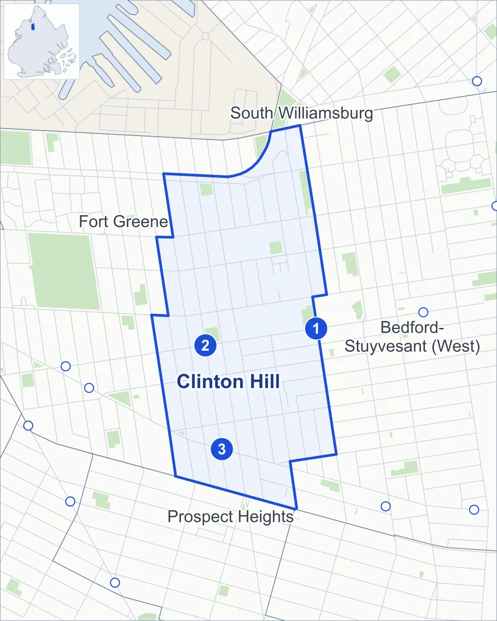
- Clinton Hill
- A neighboring area
- Park
- A station in the list
- Another station
Neighborhood areas and streets: NYC Department of City Planning. Parks: NYC Parks. Stations: MTA.
Neighboring areas
- South Williamsburg north
- Bedford-Stuyvesant (West) east
- Prospect Heights south
- Fort Greene northwest
Subway stations
- Classon Av lines G
- Clinton-Washington Avs lines G
- Clinton-Washington Avs lines C
Getting around
Three subway stations and buses on 12 routes stop in or at the edge of Clinton Hill.
- 3 subway stations
- 12 local bus routes
Local bus routes
- B25
- B26
- B38
- B45
- B48
- B52
- B54
- B57
- B62
- B69
- B93
- T440
Safety record
Between 2021 and 2025, its corners averaged more police-reported crashes than the average Brooklyn corner.
- 1,006 police-reported crashes at its corners
- 11.3 a corner, on average
- 10.5 the average Brooklyn corner
- 9 corners with a clean record
Signal or safety changes on City record, at 35 of its corners
- Leading pedestrian intervals
- 26
- Accessible pedestrian signals
- 10
- Enhanced crossings
- 4
- Turn calming
- 3
- Safety Improvement Projects
- 2
Camera tickets
In 2025 its corners had more school-zone speed camera tickets than bus-lane or red-light tickets.
- 0 red-light camera tickets
- 1,756 school-zone speed camera tickets at two corners
- 1,722 bus-lane camera tickets at one corner
- Most speed tickets
- Park Avenue & Clinton Avenue, 1,672
- Most bus-lane tickets
- Fulton Street & Clinton Avenue, 1,722
People and homes
The 2020 Census counted 28,647 residents in Clinton Hill, about 55,100 per square mile.
- 14,400 homes, 2020 Census
- 3,053 homes added since April 2010, net, by City Planning's count
Half of its 2,029 residential lots hold buildings from 1899 or earlier, and 86% of them date from before 1940, by the City's tax lot records.
NYCHA development
NYCHA's FHA Repossessed Houses (Group IX) development lies wholly or partly within Clinton Hill.
- FHA Repossessed Houses (Group IX)
- Partly within Clinton Hill
Parks and landmarks
- Parkland
- 7.4 acres of NYC Parks property
- The largest pieces
- Taaffe Playground (1.8 acres), Classon Playground (1.4 acres) and Underwood Park (1.2 acres)
- Designated landmarks
- The Pratt Row Houses, Saint Luke's Episcopal Church, the Memorial Hall and the Royal Castle Apartments, among others
- Historic district
- Clinton Hill Historic District, wholly or partly within Clinton Hill
Streets and trees
- Trees
- 2,462 in NYC Parks' records, most often London planetree, pin oak and thornless honeylocust
- Street with the most corners
- Gates Avenue, with 11 of the area's 89
- Height above sea level
- From 14 feet at Flushing Avenue & Taaffe Place to 96 feet at Lafayette Avenue & Vanderbilt Avenue
- Honorary street names
- 2 at its corners, enacted by local law
Schools and libraries
The City lists 11 schools and one library in Clinton Hill.
- Public schools
- 7
- Charter and private schools
- 4
- Library
- Clinton Hill Library
Bike share
By the station list of October 3, 2026, eight bike-share stations stand in Clinton Hill.
- 8 bike-share stations
Public safety
How complaints are countedIn 2025 the NYPD recorded 186 major felonies at places in Clinton Hill.
Recorded by the NYPD at places in Clinton Hill
- 232 major felonies in 2024 46 fewer in 2025
- 736 other felonies, misdemeanors and violations in 2025
In 2025, on the streets along the edge of Clinton Hill, the NYPD recorded another 102 major felonies. Counting the streets along its edge, in 2025 the NYPD recorded 10.1 major felonies for every thousand residents the 2020 Census counted in Clinton Hill.
- Police precincts
- 88th (most of the area), 79th
From January to June 2026 the NYPD recorded 64 major felonies at places in Clinton Hill, against 95 in the same months of 2025.
Sources: the NYPD's Complaint Data Historic, updated April 28, 2026, and Complaint Data Current (Year To Date), updated July 27, 2026, on NYC Open Data. Figures to June 30, 2026.
Street corners
- Atlantic Avenue & Clinton Avenue
- Atlantic Avenue & Grand Avenue
- Atlantic Avenue & Vanderbilt Avenue
- Brooklyn-Queens Expressway & Hall Street
- Brooklyn-Queens Expressway & Park Avenue
- Brooklyn-Queens Expressway & Ryerson Street
- Brooklyn-Queens Expressway & Washington Avenue
- Brooklyn-Queens Expressway & Waverly Avenue
- Classon Avenue & Brooklyn-Queens Expressway
- Classon Avenue & Clifton Place
- Classon Avenue & Emerson Place
- Classon Avenue & Lexington Avenue
- Clifton Place & St James Place
- Dekalb Avenue & Classon Avenue
- Dekalb Avenue & Clinton Avenue
- Dekalb Avenue & Grand Avenue
- Dekalb Avenue & Hall Street
- Dekalb Avenue & Ryerson Street
- Dekalb Avenue & Steuben Street
- Dekalb Avenue & Taaffe Place
- Dekalb Avenue & Washington Avenue
- Dekalb Avenue & Waverly Avenue
- Flushing Avenue & Taaffe Place
- Fulton Street & Cambridge Place
- Fulton Street & Clermont Avenue
- Fulton Street & Clinton Avenue
- Fulton Street & Gates Avenue
- Fulton Street & Putnam Avenue
- Fulton Street & St James Place
- Fulton Street & Vanderbilt Avenue
- Fulton Street & Washington Avenue
- Fulton Street & Waverly Avenue
- Gates Avenue & Cambridge Place
- Gates Avenue & Classon Avenue
- Gates Avenue & Clinton Avenue
- Gates Avenue & Downing Street
- Gates Avenue & Grand Avenue
- Gates Avenue & Irving Place
- Gates Avenue & St James Place
- Gates Avenue & Vanderbilt Avenue
- Gates Avenue & Waverly Avenue
- Grand Avenue & Clifton Place
- Grand Avenue & Lefferts Place
- Grand Avenue & Lexington Avenue
- Greene Avenue & Cambridge Place
- Greene Avenue & Clermont Avenue
- Greene Avenue & Clinton Avenue
- Greene Avenue & Grand Avenue
- Greene Avenue & St James Place
- Greene Avenue & Vanderbilt Avenue
- Greene Avenue & Waverly Avenue
- Lafayette Avenue & Clermont Avenue
- Lafayette Avenue & Clinton Avenue
- Lafayette Avenue & Grand Avenue
- Lafayette Avenue & St James Place
- Lafayette Avenue & Vanderbilt Avenue
- Lafayette Avenue & Washington Avenue
- Lafayette Avenue & Waverly Avenue
- Myrtle Avenue & Classon Avenue
- Myrtle Avenue & Clinton Avenue
- Myrtle Avenue & Emerson Place
- Myrtle Avenue & Grand Avenue
- Myrtle Avenue & Hall Street
- Myrtle Avenue & Ryerson Street
- Myrtle Avenue & Steuben Street
- Myrtle Avenue & Taaffe Place
- Myrtle Avenue & Waverly Avenue
- Park Avenue & Classon Avenue
- Park Avenue & Clinton Avenue
- Park Avenue & Emerson Place
- Park Avenue & Grand Avenue
- Park Avenue & Hall Street
- Park Avenue & Ryerson Street
- Park Avenue & Steuben Street
- Putnam Avenue & Downing Street
- St James Place & Lefferts Place
- Washington Avenue & Gates Avenue
- Washington Avenue & Greene Avenue
- Washington Avenue & Myrtle Avenue
- Washington Avenue & Park Avenue
- Washington Avenue & Willoughby Avenue
- Willoughby Avenue & Classon Avenue
- Willoughby Avenue & Clinton Avenue
- Willoughby Avenue & Emerson Place
- Willoughby Avenue & Grand Avenue
- Willoughby Avenue & Hall Street
- Willoughby Avenue & Ryerson Street
- Willoughby Avenue & Steuben Street
- Willoughby Avenue & Waverly Avenue
How the figures above are measured: Methodology.