Bedford-Stuyvesant (West)
Neighborhood · Brooklyn
The western half of Bedford-Stuyvesant reaches east from Classon Avenue, on the Clinton Hill line, between Flushing Avenue and Atlantic Avenue.
- 1.32 square miles
- 89,189 residents, 2020 Census
- 191 street corners
- 6 subway stations
- 14 bus routes
Its name recalls Bedford, a hamlet approved under Dutch rule in 1663 and named for the English market town, but most of its buildings went up on speculation for the city's growing middle class between about 1870 and 1920. Notable sites include the Alhambra and Renaissance apartment houses of 1889–92, Girls' High School of 1885–86, Boys' High School of 1891–92 and Herbert Von King Park, acquired in 1857 as one of the City of Brooklyn's first parks.
Sources: Bedford–Stuyvesant, Brooklyn (Wikipedia); Bedford-Stuyvesant - Historic Districts Council's Six to Celebrate (Historic Districts Council); Herbert Von King Park (NYC Parks).
Bedford-Stuyvesant (West) borders four areas, and Marcy Avenue and Tompkins Avenue hold more of its corners than any other street, 27 each of 191.
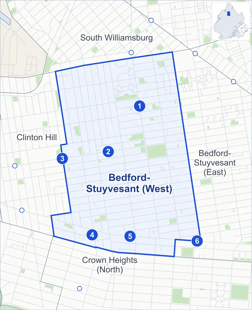
- Bedford-Stuyvesant (West)
- A neighboring area
- Park
- A station in the list
- Another station
Neighborhood areas and streets: NYC Department of City Planning. Parks: NYC Parks. Stations: MTA.
Neighboring areas
- South Williamsburg north
- Bedford-Stuyvesant (East) east
- Crown Heights (North) south
- Clinton Hill west
Subway stations
- Myrtle-Willoughby Avs lines G
- Bedford-Nostrand Avs lines G
- Classon Av lines G
- Franklin Av lines C S accessible
- Nostrand Av lines A C
- Kingston-Throop Avs lines C
Getting around
Six subway stations and buses on 14 routes stop in or at the edge of Bedford-Stuyvesant (West).
- 6 subway stations
- 1 of them listed by the MTA as fully accessible
- 14 local bus routes
Local bus routes
- B25
- B26
- B38
- B43
- B44
- B44-SBS
- B48
- B49
- B52
- B54
- B57
- B93
- T403
- T440
Safety record
Between 2021 and 2025, its corners averaged more police-reported crashes than the average Brooklyn corner.
- 4,264 police-reported crashes at its corners
- 22.3 a corner, on average
- 10.5 the average Brooklyn corner
- 2 corners with a clean record
Signal or safety changes on City record, at 128 of its corners
- Leading pedestrian intervals
- 113
- Accessible pedestrian signals
- 47
- Turn calming
- 33
- Barnes Dance all-way crossings
- 4
- Safety Improvement Projects
- 2
Camera tickets
In 2025 its corners had more school-zone speed camera tickets than red-light or bus-lane tickets.
- 2,327 red-light camera tickets at four corners
- 12,499 school-zone speed camera tickets at 17 corners
- 0 bus-lane camera tickets
- Most red-light tickets
- Lafayette Avenue & Marcy Avenue, 2,092
- Most speed tickets
- Bedford Avenue & Gates Avenue, 2,724
People and homes
The 2020 Census counted 89,189 residents in Bedford-Stuyvesant (West), about 67,600 per square mile.
- 35,840 homes, 2020 Census
- 8,615 homes added since April 2010, net, by City Planning's count
Half of its 6,629 residential lots hold buildings from 1905 or earlier, and 80% of them date from before 1940, by the City's tax lot records.
NYCHA developments
NYCHA's Lafayette, Marcy and Tompkins developments lie wholly or partly within Bedford-Stuyvesant (West).
Parks and landmarks
- Parkland
- 26.3 acres of NYC Parks property
- The largest pieces
- Herbert Von King Park (8 acres), Marcy Playground (3.2 acres) and Star Spangled Playground (1.7 acres)
- Designated landmark
- Saint George's Protestant Episcopal Church
- Historic districts
- Bedford and Willoughby-Hart, wholly or partly within Bedford-Stuyvesant (West)
Streets and trees
- Trees
- 5,595 in NYC Parks' records, most often thornless honeylocust, London planetree and pin oak
- Street with the most corners
- Marcy Avenue, with 27 of the area's 191
- Height above sea level
- From 10 feet at Marcy Avenue & Hopkins Street to 78 feet at Atlantic Avenue & Franklin Avenue
- Honorary street names
- 9 at its corners, enacted by local law
Schools and libraries
The City lists 43 schools and three libraries in Bedford-Stuyvesant (West).
- Public schools
- 17
- Charter and private schools
- 26
- Libraries
- Bedford Library, Bedford Library Learning Center and Marcy Library
Bike share
By the station list of October 3, 2026, 33 bike-share stations stand in Bedford-Stuyvesant (West).
- 33 bike-share stations
Public safety
How complaints are countedIn 2025 the NYPD recorded 994 major felonies at places in Bedford-Stuyvesant (West).
Recorded by the NYPD at places in Bedford-Stuyvesant (West)
- 951 major felonies in 2024
- 4,412 other felonies, misdemeanors and violations in 2025
In 2025, on the streets along the edge of Bedford-Stuyvesant (West), the NYPD recorded another 194 major felonies. Counting the streets along its edge, in 2025 the NYPD recorded 13.3 major felonies for every thousand residents the 2020 Census counted in Bedford-Stuyvesant (West).
- Police precincts
- 79th (most of the area), 88th
From January to June 2026 the NYPD recorded 414 major felonies at places in Bedford-Stuyvesant (West), against 453 in the same months of 2025.
Sources: the NYPD's Complaint Data Historic, updated April 28, 2026, and Complaint Data Current (Year To Date), updated July 27, 2026, on NYC Open Data. Figures to June 30, 2026.
Street corners
- Atlantic Avenue & Franklin Avenue
- Bedford Avenue & Brevoort Place
- Bedford Avenue & Clifton Place
- Bedford Avenue & Dekalb Avenue
- Bedford Avenue & Flushing Avenue
- Bedford Avenue & Fulton Street
- Bedford Avenue & Gates Avenue
- Bedford Avenue & Greene Avenue
- Bedford Avenue & Halsey Street
- Bedford Avenue & Hancock Street
- Bedford Avenue & Herkimer Street
- Bedford Avenue & Jefferson Avenue
- Bedford Avenue & Kosciuszko Street
- Bedford Avenue & Lafayette Avenue
- Bedford Avenue & Lexington Avenue
- Bedford Avenue & Madison Street
- Bedford Avenue & Monroe Street
- Bedford Avenue & Myrtle Avenue
- Bedford Avenue & Park Avenue
- Bedford Avenue & Putnam Avenue
- Bedford Avenue & Quincy Street
- Bedford Avenue & Willoughby Avenue
- Brevoort Place & Bedford Place
- Brooklyn Avenue & Herkimer Street
- Classon Avenue & Lefferts Place
- Decatur Street & Tompkins Avenue
- Dekalb Avenue & Franklin Avenue
- Dekalb Avenue & Kent Avenue
- Dekalb Avenue & Marcy Avenue
- Dekalb Avenue & Skillman Street
- Dekalb Avenue & Spencer Street
- Dekalb Avenue & Throop Avenue
- Dekalb Avenue & Tompkins Avenue
- Dekalb Avenue & Walworth Street
- Ellery Street & Delmonico Place
- Flushing Avenue & Franklin Avenue
- Flushing Avenue & Gerry Street
- Flushing Avenue & Skillman Street
- Flushing Avenue & Spencer Street
- Flushing Avenue & Walworth Street
- Flushing Avenue & Whipple Street
- Franklin Avenue & Brevoort Place
- Franklin Avenue & Clifton Place
- Franklin Avenue & Lefferts Place
- Franklin Avenue & Lexington Avenue
- Franklin Avenue & Quincy Street
- Fulton Street & Arlington Place
- Fulton Street & Brooklyn Avenue
- Fulton Street & Classon Avenue
- Fulton Street & Claver Place
- Fulton Street & Downing Street
- Fulton Street & Franklin Avenue
- Fulton Street & Grand Avenue
- Fulton Street & Irving Place
- Fulton Street & Kingston Avenue
- Fulton Street & Marcy Avenue
- Fulton Street & New York Avenue
- Fulton Street & Spencer Place
- Fulton Street & Verona Place
- Gates Avenue & Franklin Avenue
- Gates Avenue & Marcy Avenue
- Gates Avenue & Tompkins Avenue
- Greene Avenue & Classon Avenue
- Greene Avenue & Franklin Avenue
- Greene Avenue & Marcy Avenue
- Greene Avenue & Throop Avenue
- Greene Avenue & Tompkins Avenue
- Halsey Street & Arlington Place
- Halsey Street & Marcy Avenue
- Halsey Street & Tompkins Avenue
- Hancock Street & Franklin Avenue
- Hancock Street & Spencer Place
- Hancock Street & Tompkins Avenue
- Hart Street & Tompkins Avenue
- Herkimer Street & Herkimer Court
- Jefferson Avenue & Claver Place
- Jefferson Avenue & Franklin Avenue
- Jefferson Avenue & Tompkins Avenue
- Kent Avenue & Little Nassau Street
- Kosciuszko Street & Spencer Court
- Kosciuszko Street & Tompkins Avenue
- Lafayette Avenue & Classon Avenue
- Lafayette Avenue & Franklin Avenue
- Lafayette Avenue & Marcy Avenue
- Lafayette Avenue & Skillman Street
- Lafayette Avenue & Throop Avenue
- Lafayette Avenue & Tompkins Avenue
- Lexington Avenue & Tompkins Avenue
- MacDonough Street & Tompkins Avenue
- Macon Street & Arlington Place
- Macon Street & Tompkins Avenue
- Macon Street & Verona Place
- Madison Street & Classon Avenue
- Madison Street & Franklin Avenue
- Madison Street & Marcy Avenue
- Madison Street & Tompkins Avenue
- Marcy Avenue & Clifton Place
- Marcy Avenue & Ellery Street
- Marcy Avenue & Hancock Street
- Marcy Avenue & Hart Street
- Marcy Avenue & Hopkins Street
- Marcy Avenue & Jefferson Avenue
- Marcy Avenue & Kosciuszko Street
- Marcy Avenue & Lexington Avenue
- Marcy Avenue & MacDonough Street
- Marcy Avenue & Macon Street
- Marcy Avenue & Martin Luther King Jr Place
- Marcy Avenue & Monroe Street
- Marcy Avenue & Park Avenue
- Marcy Avenue & Pulaski Street
- Marcy Avenue & Quincy Street
- Marcy Avenue & Stockton Street
- Marcy Avenue & Vernon Avenue
- Monroe Street & Classon Avenue
- Monroe Street & Franklin Avenue
- Monroe Street & Tompkins Avenue
- Myrtle Avenue & Franklin Avenue
- Myrtle Avenue & Kent Avenue
- Myrtle Avenue & Marcy Avenue
- Myrtle Avenue & Sandford Street
- Myrtle Avenue & Skillman Street
- Myrtle Avenue & Spencer Street
- Myrtle Avenue & Throop Avenue
- Myrtle Avenue & Tompkins Avenue
- Myrtle Avenue & Walworth Street
- New York Avenue & Herkimer Street
- Nostrand Avenue & Clifton Place
- Nostrand Avenue & Dekalb Avenue
- Nostrand Avenue & Fulton Street
- Nostrand Avenue & Gates Avenue
- Nostrand Avenue & Greene Avenue
- Nostrand Avenue & Halsey Street
- Nostrand Avenue & Hancock Street
- Nostrand Avenue & Hart Street
- Nostrand Avenue & Herkimer Place
- Nostrand Avenue & Herkimer Street
- Nostrand Avenue & Jefferson Avenue
- Nostrand Avenue & Kosciuszko Street
- Nostrand Avenue & Lafayette Avenue
- Nostrand Avenue & Lexington Avenue
- Nostrand Avenue & Macon Street
- Nostrand Avenue & Madison Street
- Nostrand Avenue & Monroe Street
- Nostrand Avenue & Myrtle Avenue
- Nostrand Avenue & Park Avenue
- Nostrand Avenue & Pulaski Street
- Nostrand Avenue & Putnam Avenue
- Nostrand Avenue & Quincy Street
- Nostrand Avenue & Vernon Avenue
- Nostrand Avenue & Willoughby Avenue
- Park Avenue & Delmonico Place
- Park Avenue & Franklin Avenue
- Park Avenue & Kent Avenue
- Park Avenue & Sandford Street
- Park Avenue & Skillman Street
- Park Avenue & Spencer Street
- Park Avenue & Taaffe Place
- Park Avenue & Throop Avenue
- Park Avenue & Tompkins Avenue
- Park Avenue & Walworth Street
- Putnam Avenue & Classon Avenue
- Putnam Avenue & Claver Place
- Putnam Avenue & Franklin Avenue
- Putnam Avenue & Grand Avenue
- Putnam Avenue & Irving Place
- Putnam Avenue & Marcy Avenue
- Putnam Avenue & Tompkins Avenue
- Quincy Street & Classon Avenue
- Quincy Street & Tompkins Avenue
- Taaffe Place & Little Nassau Street
- Throop Avenue & Ellery Street
- Throop Avenue & Hopkins Street
- Throop Avenue & Pulaski Street
- Throop Avenue & Van Buren Street
- Tompkins Avenue & Ellery Street
- Tompkins Avenue & Hopkins Street
- Tompkins Avenue & Martin Luther King Jr Place
- Tompkins Avenue & Pulaski Street
- Tompkins Avenue & Stockton Street
- Tompkins Avenue & Van Buren Street
- Tompkins Avenue & Vernon Avenue
- Willoughby Avenue & Franklin Avenue
- Willoughby Avenue & Kent Avenue
- Willoughby Avenue & Marcy Avenue
- Willoughby Avenue & Sandford Street
- Willoughby Avenue & Skillman Street
- Willoughby Avenue & Spencer Street
- Willoughby Avenue & Taaffe Place
- Willoughby Avenue & Throop Avenue
- Willoughby Avenue & Tompkins Avenue
- Willoughby Avenue & Walworth Street
How the figures above are measured: Methodology.