Crown Heights (North)
Neighborhood · Brooklyn
North of Eastern Parkway, this part of Crown Heights reaches up to Atlantic Avenue in central Brooklyn and includes historic Weeksville east of Albany Avenue.
- 1.27 square miles
- 85,275 residents, 2020 Census
- 165 street corners
- 5 subway stations
- 17 bus routes
African Americans settled Weeksville soon after slavery ended in New York in 1827, and it became one of the largest free Black communities in America before the Civil War; its surviving Hunterfly Road Houses are now the Weeksville Heritage Center. Hundreds of freestanding houses and rowhouses went up between 1888 and 1893, followed by apartment houses from the 1920s, and the Brooklyn Children's Museum, founded in 1899 as the world's first, is on Brooklyn Avenue.
Sources: Crown Heights North Historic District Designation Report (NYC Landmarks Preservation Commission); Weeksville Heritage Center; Weeksville, Brooklyn (Wikipedia); History & Mission (Brooklyn Children's Museum).
Crown Heights (North) borders seven areas, and Bergen Street holds more of its corners than any other street, 21 of 165.
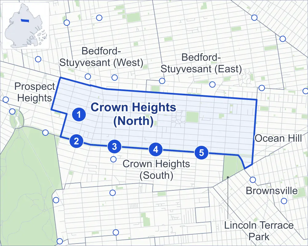
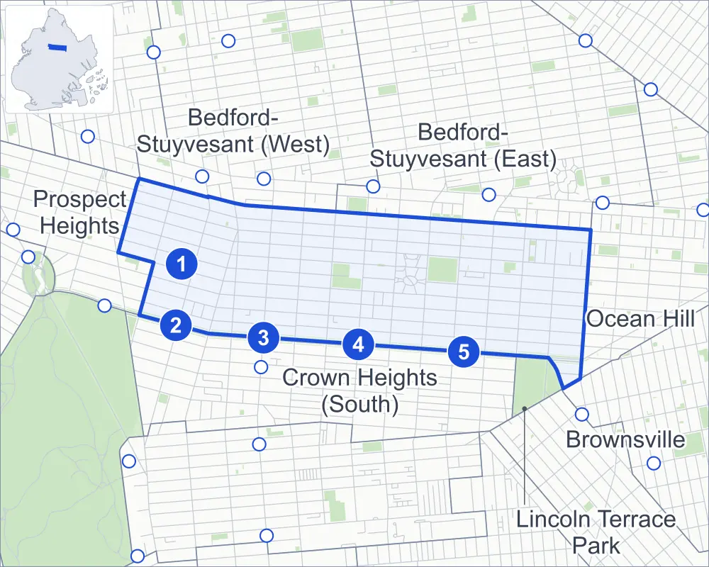
- Crown Heights (North)
- A neighboring area
- Park
- A station in the list
- Another station
Neighborhood areas and streets: NYC Department of City Planning. Parks: NYC Parks. Stations: MTA.
Neighboring areas
- Bedford-Stuyvesant (East) northeast
- Ocean Hill east
- Lincoln Terrace Park southeast
- Brownsville southeast
- Crown Heights (South) southwest
- Prospect Heights west
- Bedford-Stuyvesant (West) northwest
Subway stations
- Park Pl lines S accessible
- Franklin Av-Medgar Evers College lines 2 3 4 5
- Nostrand Av lines 3
- Kingston Av lines 3
- Crown Hts-Utica Av lines 3 4 accessible
Getting around
Five subway stations and buses on 17 routes stop in or at the edge of Crown Heights (North).
- 5 subway stations
- 2 of them listed by the MTA as fully accessible
- 17 local bus routes
Local bus routes
- B12
- B14
- B15
- B17
- B43
- B44
- B44-SBS
- B45
- B46
- B46-SBS
- B47
- B48
- B49
- B65
- B96
- B99
- T440
Safety record
Between 2021 and 2025, its corners averaged more police-reported crashes than the average Brooklyn corner.
- 4,621 police-reported crashes at its corners
- 28.0 a corner, on average
- 10.5 the average Brooklyn corner
- 3 corners with a clean record
Signal or safety changes on City record, at 109 of its corners
- Leading pedestrian intervals
- 103
- Accessible pedestrian signals
- 33
- Turn calming
- 24
- Safety Improvement Projects
- 3
- Barnes Dance all-way crossings
- 1
Camera tickets
In 2025 its corners had more school-zone speed camera tickets than red-light or bus-lane tickets.
- 25,775 red-light camera tickets at six corners
- 45,596 school-zone speed camera tickets at 18 corners
- 2,541 bus-lane camera tickets at four corners
- Most red-light tickets
- Bedford Avenue & Atlantic Avenue, 13,019
- Most speed tickets
- Atlantic Avenue & Classon Avenue, 17,891
- Most bus-lane tickets
- Dean Street & Utica Avenue, 1,410
People and homes
The 2020 Census counted 85,275 residents in Crown Heights (North), about 67,100 per square mile.
- 38,277 homes, 2020 Census
- 5,500 homes added since April 2010, net, by City Planning's count
Half of its 5,612 residential lots hold buildings from 1910 or earlier, and 91% of them date from before 1940, by the City's tax lot records.
NYCHA developments
NYCHA's Albany, Albany II, Kingsborough Extension and Kingsborough developments lie wholly or partly within Crown Heights (North).
- Albany
- Within Crown Heights (North)
- Albany II
- Within Crown Heights (North)
- Kingsborough Extension
- Within Crown Heights (North)
- Kingsborough
- Partly within Crown Heights (North)
Parks and landmarks
- Parkland
- 18.7 acres of NYC Parks property
- The largest pieces
- St. John's Park (9 acres), Brower Park (7 acres) and Woods Playground (1.4 acres)
- Designated landmarks
- The Studebaker Building, Saint Bartholomew's Church and 23rd Regiment Armory
- Historic districts
- Crown Heights North, Crown Heights North II, Crown Heights North III and Park Place, wholly or partly within Crown Heights (North)
Streets and trees
- Trees
- 5,564 in NYC Parks' records, most often American elm, pin oak and thornless honeylocust
- Street with the most corners
- Bergen Street, with 21 of the area's 165
- Height above sea level
- From 59 feet at Atlantic Avenue & Brooklyn Avenue to 138 feet at Eastern Parkway & Rogers Avenue
- Honorary street names
- 16 at its corners, enacted by local law
Schools and libraries
The City lists 35 schools and one library in Crown Heights (North).
- Public schools
- 15
- Charter and private schools
- 20
- Library
- Brower Park Library
Bike share and public art
By the station list of October 3, 2026, 38 bike-share stations stand in Crown Heights (North). The City's public art inventory lists two works in the area: Ulysses Simpson Grant (1896) and Sugar in My Bowl II (2012).
- 38 bike-share stations
- 2 works of public art
Public safety
How complaints are countedIn 2025 the NYPD recorded 1,066 major felonies at places in Crown Heights (North).
Recorded by the NYPD at places in Crown Heights (North)
- 909 major felonies in 2024
- 3,384 other felonies, misdemeanors and violations in 2025
In 2025, on the streets along the edge of Crown Heights (North), the NYPD recorded another 322 major felonies. Counting the streets along its edge, in 2025 the NYPD recorded 16.3 major felonies for every thousand residents the 2020 Census counted in Crown Heights (North).
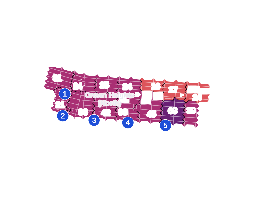
- 5 to 9
- 10 to 19
- 20 to 49
- 50 to 99
- 100 or more
- Not shaded: fewer than 5, held back under the rules in How complaints are counted, parks and public-housing grounds, and land in no patch
- Police precinct
- 77th
From January to June 2026 the NYPD recorded 429 major felonies at places in Crown Heights (North), against 487 in the same months of 2025.
Sources: the NYPD's Complaint Data Historic, updated April 28, 2026, and Complaint Data Current (Year To Date), updated July 27, 2026, on NYC Open Data. Figures to June 30, 2026.
Street corners
- Albany Avenue & Eastern Parkway
- Albany Avenue & Lincoln Place
- Albany Avenue & St Johns Place
- Albany Avenue & Sterling Place
- Atlantic Avenue & Albany Avenue
- Atlantic Avenue & Brooklyn Avenue
- Atlantic Avenue & Buffalo Avenue
- Atlantic Avenue & Classon Avenue
- Atlantic Avenue & Kingston Avenue
- Atlantic Avenue & New York Avenue
- Atlantic Avenue & Ralph Avenue
- Atlantic Avenue & Rochester Avenue
- Atlantic Avenue & Schenectady Avenue
- Atlantic Avenue & Troy Avenue
- Atlantic Avenue & Utica Avenue
- Bedford Avenue & Atlantic Avenue
- Bedford Avenue & Bergen Street
- Bedford Avenue & Dean Street
- Bedford Avenue & Lincoln Place
- Bedford Avenue & Pacific Street
- Bedford Avenue & Park Place
- Bedford Avenue & Prospect Place
- Bedford Avenue & St Johns Place
- Bedford Avenue & St Marks Avenue
- Bedford Avenue & Sterling Place
- Bergen Street & Albany Avenue
- Bergen Street & Brooklyn Avenue
- Bergen Street & Buffalo Avenue
- Bergen Street & Classon Avenue
- Bergen Street & Franklin Avenue
- Bergen Street & Grand Avenue
- Bergen Street & Kingsborough 1st Walk
- Bergen Street & Kingsborough 2nd Walk
- Bergen Street & Kingsborough 3rd Walk
- Bergen Street & Kingsborough 5th Walk
- Bergen Street & Kingsborough 6th Walk
- Bergen Street & Kingston Avenue
- Bergen Street & New York Avenue
- Bergen Street & Revere Place
- Bergen Street & Rochester Avenue
- Bergen Street & Rogers Avenue
- Bergen Street & Schenectady Avenue
- Bergen Street & Troy Avenue
- Bergen Street & Utica Avenue
- Brooklyn Avenue & Lincoln Place
- Brooklyn Avenue & St Johns Place
- Brooklyn Avenue & Sterling Place
- Dean Street & Albany Avenue
- Dean Street & Brooklyn Avenue
- Dean Street & Classon Avenue
- Dean Street & Franklin Avenue
- Dean Street & Kingston Avenue
- Dean Street & New York Avenue
- Dean Street & Revere Place
- Dean Street & Rochester Avenue
- Dean Street & Schenectady Avenue
- Dean Street & Troy Avenue
- Dean Street & Utica Avenue
- Eastern Parkway & Buffalo Avenue
- Eastern Parkway & Franklin Avenue
- Eastern Parkway & Rochester Avenue
- Eastern Parkway & Rogers Avenue
- Franklin Avenue & St Johns Place
- Lincoln Place & Buffalo Avenue
- Lincoln Place & Franklin Avenue
- Lincoln Place & Kingston Avenue
- Lincoln Place & Rochester Avenue
- Lincoln Place & Rogers Avenue
- Lincoln Place & St Charles Place
- Lincoln Place & St Francis Place
- New York Avenue & Lincoln Place
- New York Avenue & Prospect Place
- New York Avenue & St Johns Place
- New York Avenue & St Marks Avenue
- New York Avenue & Sterling Place
- Nostrand Avenue & Atlantic Avenue
- Nostrand Avenue & Bergen Street
- Nostrand Avenue & Dean Street
- Nostrand Avenue & Lincoln Place
- Nostrand Avenue & Pacific Street
- Nostrand Avenue & Park Place
- Nostrand Avenue & Prospect Place
- Nostrand Avenue & St Johns Place
- Nostrand Avenue & St Marks Avenue
- Nostrand Avenue & Sterling Place
- Pacific Street & Albany Avenue
- Pacific Street & Brooklyn Avenue
- Pacific Street & Buffalo Avenue
- Pacific Street & Classon Avenue
- Pacific Street & Franklin Avenue
- Pacific Street & Grand Avenue
- Pacific Street & Kingsborough 1st Walk
- Pacific Street & Kingsborough 2nd Walk
- Pacific Street & Kingsborough 3rd Walk
- Pacific Street & Kingston Avenue
- Pacific Street & New York Avenue
- Pacific Street & Ralph Avenue
- Pacific Street & Rochester Avenue
- Pacific Street & Schenectady Avenue
- Pacific Street & Troy Avenue
- Pacific Street & Utica Avenue
- Park Place & Albany Avenue
- Park Place & Brooklyn Avenue
- Park Place & Buffalo Avenue
- Park Place & Franklin Avenue
- Park Place & Hampton Place
- Park Place & Kingston Avenue
- Park Place & New York Avenue
- Park Place & Rochester Avenue
- Park Place & Rogers Avenue
- Park Place & Schenectady Avenue
- Park Place & Troy Avenue
- Park Place & Virginia Place
- Prospect Place & Albany Avenue
- Prospect Place & Brooklyn Avenue
- Prospect Place & Buffalo Avenue
- Prospect Place & Classon Avenue
- Prospect Place & Franklin Avenue
- Prospect Place & Grand Avenue
- Prospect Place & Kingston Avenue
- Prospect Place & Rochester Avenue
- Prospect Place & Rogers Avenue
- Prospect Place & Troy Avenue
- Ralph Avenue & Prospect Place
- Ralph Avenue & St Johns Place
- Schenectady Avenue & Lincoln Place
- Schenectady Avenue & Prospect Place
- Schenectady Avenue & St Johns Place
- Schenectady Avenue & St Marks Avenue
- Schenectady Avenue & Sterling Place
- St Johns Place & Buffalo Avenue
- St Johns Place & Classon Avenue
- St Johns Place & Hampton Place
- St Johns Place & Kingston Avenue
- St Johns Place & Rochester Avenue
- St Johns Place & Rogers Avenue
- St Johns Place & St Charles Place
- St Johns Place & St Francis Place
- St Marks Avenue & Albany Avenue
- St Marks Avenue & Brooklyn Avenue
- St Marks Avenue & Buffalo Avenue
- St Marks Avenue & Classon Avenue
- St Marks Avenue & Franklin Avenue
- St Marks Avenue & Grand Avenue
- St Marks Avenue & Kingston Avenue
- St Marks Avenue & Rochester Avenue
- St Marks Avenue & Rogers Avenue
- Sterling Place & Buffalo Avenue
- Sterling Place & Classon Avenue
- Sterling Place & Franklin Avenue
- Sterling Place & Hampton Place
- Sterling Place & Kingston Avenue
- Sterling Place & Rochester Avenue
- Sterling Place & Rogers Avenue
- Sterling Place & Virginia Place
- Troy Avenue & Lincoln Place
- Troy Avenue & St Johns Place
- Troy Avenue & Sterling Place
- Union Street & Portal Street
- Utica Avenue & Lincoln Place
- Utica Avenue & Park Place
- Utica Avenue & Prospect Place
- Utica Avenue & St Johns Place
- Utica Avenue & St Marks Avenue
- Utica Avenue & Sterling Place
How the figures above are measured: Methodology.