Brownsville
Neighborhood · Brooklyn
Set between East Flatbush and East New York in Brooklyn, with Ocean Hill to the north and Canarsie to the south, Brownsville takes its name from Charles S. Brown, who acquired the land in the mid-1860s and divided it into lots.
- 1.10 square miles
- 60,470 residents, 2020 Census
- 200 street corners
- 8 subway stations
- 10 bus routes
Tenements followed from 1887, and after the Fulton Street el arrived in 1889 and the Williamsburg Bridge opened in 1903, Brownsville and East New York had the city's largest concentration of Jewish residents in 1925; in 1942 hundreds of stores lined Pitkin Avenue. Its landmarks include the Stone Avenue library, opened in 1914 as the Brownsville Children's Library, and the Betsy Head pool of 1936.
Sources: Betsy Head Play Center (LP-2240) (NYC Landmarks Preservation Commission); Brooklyn Public Library, Stone Avenue Branch (LP-2568) (NYC Landmarks Preservation Commission); Brownsville, Brooklyn (Wikipedia).
Brownsville borders five areas, and Sutter Avenue holds more of its corners than any other street, 21 of 200.
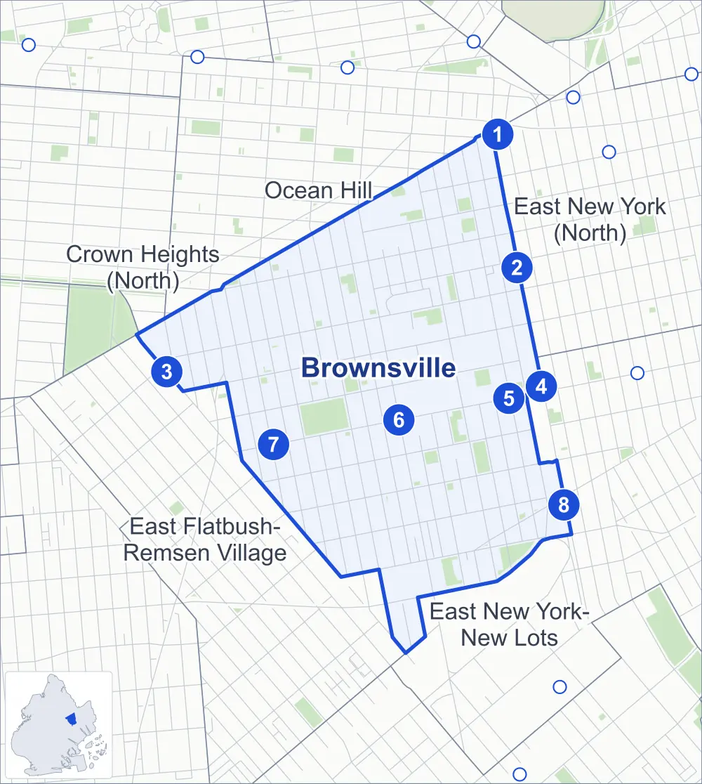
- Brownsville
- A neighboring area
- Park
- A station in the list
- Another station
Neighborhood areas and streets: NYC Department of City Planning. Parks: NYC Parks. Stations: MTA.
Neighboring areas
- Ocean Hill north
- East New York (North) northeast
- East New York-New Lots southeast
- East Flatbush-Remsen Village southwest
- Crown Heights (North) west
Subway stations
- Atlantic Av lines L
- Sutter Av lines L
- Sutter Av-Rutland Rd lines 3
- Livonia Av lines L accessible
- Junius St lines 3
- Rockaway Av lines 3
- Saratoga Av lines 3
- New Lots Av lines L
Getting around
Eight subway stations and buses on ten routes stop in or at the edge of Brownsville.
- 8 subway stations
- 1 of them listed by the MTA as fully accessible
- 10 local bus routes
Local bus routes
- B7
- B8
- B12
- B14
- B15
- B35
- B47
- B60
- B99
- T426
Safety record
Between 2021 and 2025, its corners averaged more police-reported crashes than the average Brooklyn corner.
- 2,774 police-reported crashes at its corners
- 13.9 a corner, on average
- 10.5 the average Brooklyn corner
- 2 corners with a clean record
Signal or safety changes on City record, at 83 of its corners
- Leading pedestrian intervals
- 70
- Accessible pedestrian signals
- 23
- Turn calming
- 8
- Barnes Dance all-way crossings
- 5
- Enhanced crossings
- 4
- Safety Improvement Projects
- 4
Camera tickets
In 2025 its corners had more school-zone speed camera tickets than red-light or bus-lane tickets.
- 2,775 red-light camera tickets at one corner
- 13,365 school-zone speed camera tickets at 12 corners
- 0 bus-lane camera tickets
- Most red-light tickets
- Linden Boulevard & Rockaway Avenue, 2,775
- Most speed tickets
- Linden Boulevard & Rockaway Avenue, 8,788
People and homes
The 2020 Census counted 60,470 residents in Brownsville, about 55,000 per square mile.
- 21,765 homes, 2020 Census
- 4,372 homes added since April 2010, net, by City Planning's count
Half of its 3,569 residential lots hold buildings from 1985 or earlier, and 47% of them date from before 1940, by the City's tax lot records.
NYCHA developments
NYCHA's Brownsville, Garvey (Group A), Glenmore Plaza, Howard, Hughes Apartments, Low Houses, Tilden, Van Dyke I, Van Dyke II and Woodson developments lie wholly or partly within Brownsville.
Parks and landmarks
- Parkland
- 33.8 acres of NYC Parks property
- The largest pieces
- Betsy Head Park (10.6 acres), Brownsville Playground (3.1 acres) and Floyd Patterson Ballfields (2.4 acres)
- Designated landmarks
- The Betsy Head Play Center and the Brooklyn Public Library's Stone Avenue Branch
Streets and trees
- Trees
- 4,824 in NYC Parks' records, most often London planetree, thornless honeylocust and pin oak
- Street with the most corners
- Sutter Avenue, with 21 of the area's 200
- Height above sea level
- From 14 feet at Linden Boulevard & Mother Gaston Boulevard to 64 feet at East New York Avenue & Powell Street
- Honorary street names
- 5 at its corners, enacted by local law
Schools and libraries
The City lists 33 schools and two libraries in Brownsville.
- Public schools
- 26
- Charter and private schools
- 7
- Libraries
- Brownsville Library and Stone Avenue Library
Bike share and public art
By the station list of October 3, 2026, 28 bike-share stations stand in Brownsville. The City's public art inventory lists two works in the area: Zion Park War Memorial (1925) and Face to Face (1984).
- 28 bike-share stations
- 2 works of public art
Public safety
How complaints are countedIn 2025 the NYPD recorded 1,191 major felonies at places in Brownsville.
Recorded by the NYPD at places in Brownsville
- 899 major felonies in 2024
- 4,905 other felonies, misdemeanors and violations in 2025
In 2025, on the streets along the edge of Brownsville, the NYPD recorded another 146 major felonies. Counting the streets along its edge, in 2025 the NYPD recorded 22.1 major felonies for every thousand residents the 2020 Census counted in Brownsville.
- Police precinct
- 73rd
From January to June 2026 the NYPD recorded 468 major felonies at places in Brownsville, against 583 in the same months of 2025.
Sources: the NYPD's Complaint Data Historic, updated April 28, 2026, and Complaint Data Current (Year To Date), updated July 27, 2026, on NYC Open Data. Figures to June 30, 2026.
Street corners
- Amboy Street & Lott Avenue
- Amboy Street & Newport Street
- Belmont Avenue & Christopher Avenue
- Belmont Avenue & Junius Street
- Belmont Avenue & Mother Gaston Boulevard
- Belmont Avenue & Osborn Street
- Belmont Avenue & Powell Street
- Belmont Avenue & Sackman Street
- Belmont Avenue & Thatford Avenue
- Belmont Avenue & Van Sinderen Avenue
- Belmont Avenue & Watkins Street
- Bergen Street & East New York Avenue
- Blake Avenue & Amboy Street
- Blake Avenue & Bristol Street
- Blake Avenue & Chester Street
- Blake Avenue & Grafton Street
- Blake Avenue & Herzl Street
- Blake Avenue & Howard Avenue
- Blake Avenue & Junius Street
- Blake Avenue & Legion Street
- Blake Avenue & Mother Gaston Boulevard
- Blake Avenue & Osborn Street
- Blake Avenue & Powell Street
- Blake Avenue & Rockaway Avenue
- Blake Avenue & Saratoga Avenue
- Blake Avenue & Strauss Street
- Blake Avenue & Thomas S Boyland Street
- Bristol Street & Lott Avenue
- Bristol Street & Newport Street
- Bristol Street & Riverdale Avenue
- Chester Street & Lott Avenue
- Chester Street & Newport Street
- Christopher Avenue & Lott Avenue
- Christopher Avenue & Newport Street
- Dean Street & East New York Avenue
- Ditmas Avenue & Bristol Street
- Ditmas Avenue & Chester Street
- Ditmas Avenue & East 98th Street
- Dumont Avenue & Amboy Street
- Dumont Avenue & Bristol Street
- Dumont Avenue & Chester Street
- Dumont Avenue & Grafton Street
- Dumont Avenue & Herzl Street
- Dumont Avenue & Howard Avenue
- Dumont Avenue & Junius Street
- Dumont Avenue & Legion Street
- Dumont Avenue & Mother Gaston Boulevard
- Dumont Avenue & Osborn Street
- Dumont Avenue & Powell Street
- Dumont Avenue & Rockaway Avenue
- Dumont Avenue & Saratoga Avenue
- Dumont Avenue & Strauss Street
- Dumont Avenue & Thomas S Boyland Street
- Dumont Avenue & Van Sinderen Avenue
- East 98th Street & Legion Street
- East 98th Street & Lenox Road
- East 98th Street & Lott Avenue
- East 98th Street & Riverdale Avenue
- East 98th Street & Rutland Road
- East 98th Street & Saratoga Avenue
- East New York Avenue & Chester Street
- East New York Avenue & Christopher Avenue
- East New York Avenue & East 98th Street
- East New York Avenue & Portal Street
- East New York Avenue & Powell Street
- East New York Avenue & Rockaway Avenue
- East New York Avenue & Sackman Street
- East New York Avenue & St Johns Place
- East New York Avenue & Thomas S Boyland Street
- Glenmore Avenue & Christopher Avenue
- Glenmore Avenue & Junius Street
- Glenmore Avenue & Mother Gaston Boulevard
- Glenmore Avenue & Powell Street
- Glenmore Avenue & Rockaway Avenue
- Glenmore Avenue & Sackman Street
- Glenmore Avenue & Watkins Street
- Hegeman Avenue & Bristol Street
- Hegeman Avenue & Chester Street
- Hegeman Avenue & Christopher Avenue
- Hegeman Avenue & Junius Street
- Hegeman Avenue & Mother Gaston Boulevard
- Hegeman Avenue & New Lots Avenue
- Hegeman Avenue & Osborn Street
- Hegeman Avenue & Powell Street
- Hegeman Avenue & Sackman Street
- Hegeman Avenue & Thatford Avenue
- Herzl Street & Lott Avenue
- Junius Street & Lott Avenue
- Junius Street & Newport Street
- Liberty Avenue & Christopher Avenue
- Liberty Avenue & Junius Street
- Liberty Avenue & Mother Gaston Boulevard
- Liberty Avenue & Powell Street
- Liberty Avenue & Sackman Street
- Linden Boulevard & Avenue D
- Linden Boulevard & Mother Gaston Boulevard
- Linden Boulevard & Rockaway Avenue
- Linden Boulevard & Thomas S Boyland Street
- Livonia Avenue & Amboy Street
- Livonia Avenue & Bristol Street
- Livonia Avenue & Chester Street
- Livonia Avenue & Christopher Avenue
- Livonia Avenue & Grafton Street
- Livonia Avenue & Herzl Street
- Livonia Avenue & Legion Street
- Livonia Avenue & Mother Gaston Boulevard
- Livonia Avenue & Powell Street
- Livonia Avenue & Sackman Street
- Livonia Avenue & Saratoga Avenue
- Livonia Avenue & Strauss Street
- Livonia Avenue & Watkins Street
- Lott Avenue & Osborn Street
- Mother Gaston Boulevard & Lott Avenue
- Mother Gaston Boulevard & Newport Street
- Mother Gaston Boulevard & Riverdale Avenue
- New Lots Avenue & Christopher Avenue
- New Lots Avenue & Junius Street
- New Lots Avenue & Mother Gaston Boulevard
- New Lots Avenue & Powell Street
- New Lots Avenue & Sackman Street
- Newport Street & Herzl Street
- Newport Street & Osborn Street
- Newport Street & Thatford Avenue
- Newport Street & Watkins Street
- Pitkin Avenue & Amboy Street
- Pitkin Avenue & Bristol Street
- Pitkin Avenue & Chester Street
- Pitkin Avenue & Christopher Avenue
- Pitkin Avenue & Grafton Street
- Pitkin Avenue & Herzl Street
- Pitkin Avenue & Junius Street
- Pitkin Avenue & Legion Street
- Pitkin Avenue & Mother Gaston Boulevard
- Pitkin Avenue & Osborn Street
- Pitkin Avenue & Powell Street
- Pitkin Avenue & Rockaway Avenue
- Pitkin Avenue & Sackman Street
- Pitkin Avenue & Saratoga Avenue
- Pitkin Avenue & Strauss Street
- Pitkin Avenue & Thatford Avenue
- Pitkin Avenue & Thomas S Boyland Street
- Pitkin Avenue & Van Sinderen Avenue
- Pitkin Avenue & Watkins Street
- Powell Street & Lott Avenue
- Powell Street & Newport Street
- Powell Street & Riverdale Avenue
- Prospect Place & East New York Avenue
- Ralph Avenue & East 98th Street
- Ralph Avenue & East New York Avenue
- Ralph Avenue & Sutter Avenue
- Riverdale Avenue & Amboy Street
- Riverdale Avenue & Chester Street
- Riverdale Avenue & Christopher Avenue
- Riverdale Avenue & Herzl Street
- Riverdale Avenue & Legion Street
- Riverdale Avenue & Osborn Street
- Riverdale Avenue & Sackman Street
- Riverdale Avenue & Strauss Street
- Riverdale Avenue & Thatford Avenue
- Riverdale Avenue & Watkins Street
- Rockaway Avenue & Belmont Avenue
- Rockaway Avenue & Hegeman Avenue
- Rockaway Avenue & Livonia Avenue
- Rockaway Avenue & Lott Avenue
- Rockaway Avenue & Newport Street
- Rockaway Avenue & Riverdale Avenue
- Sackman Street & Lott Avenue
- Sackman Street & Newport Street
- Saratoga Avenue & Newport Street
- Saratoga Avenue & Riverdale Avenue
- Strauss Street & Lott Avenue
- Strauss Street & Newport Street
- Sutter Avenue & Amboy Street
- Sutter Avenue & Bristol Street
- Sutter Avenue & Chester Street
- Sutter Avenue & Christopher Avenue
- Sutter Avenue & East 98th Street
- Sutter Avenue & Grafton Street
- Sutter Avenue & Herzl Street
- Sutter Avenue & Howard Avenue
- Sutter Avenue & Junius Street
- Sutter Avenue & Legion Street
- Sutter Avenue & Mother Gaston Boulevard
- Sutter Avenue & Osborn Street
- Sutter Avenue & Powell Street
- Sutter Avenue & Rockaway Avenue
- Sutter Avenue & Sackman Street
- Sutter Avenue & Saratoga Avenue
- Sutter Avenue & Strauss Street
- Sutter Avenue & Tapscott Street
- Sutter Avenue & Thomas S Boyland Street
- Thatford Avenue & Lott Avenue
- Thomas S Boyland Street & Hegeman Avenue
- Thomas S Boyland Street & Livonia Avenue
- Thomas S Boyland Street & Lott Avenue
- Thomas S Boyland Street & Newport Street
- Thomas S Boyland Street & Riverdale Avenue
- Union Street & East New York Avenue
- Union Street & Sutter Avenue
- Watkins Street & Lott Avenue
How the figures above are measured: Methodology.