East New York (North)
Neighborhood · Brooklyn
East New York (North) takes in the northern blocks of East New York, a residential neighborhood in eastern Brooklyn.
- 1.00 square mile
- 42,818 residents, 2020 Census
- 204 street corners
- 7 subway stations
- 14 bus routes
The Dutch knew the land as Ostwout, or east woods, and in 1835 Connecticut merchant John Pitkin, the namesake of Pitkin Avenue, and a partner bought three farms here and called them East New York, a name meant to suggest a tie to the city to the west. Growth came with horsecars in 1859, the Williamsburg Bridge in 1903 and the subway in 1922, and the Empire State Dairy buildings on Atlantic Avenue, with tile panels showing cows in Alpine fields, became a city landmark in 2017.
Sources: Designation Report: Empire State Dairy Company Buildings (NYC Landmarks Preservation Commission); Linwood Playground History (NYC Parks); East New York, Brooklyn (Wikipedia).
East New York (North) borders five areas, and Glenmore Avenue holds more of its corners than any other street, 31 of 204.
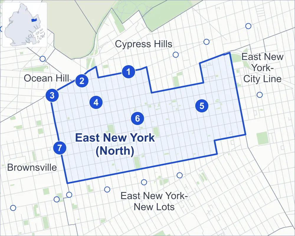
- East New York (North)
- A neighboring area
- Park
- A station in the list
- Another station
Neighborhood areas and streets: NYC Department of City Planning. Parks: NYC Parks. Stations: MTA.
Neighboring areas
- Cypress Hills north
- East New York-City Line east
- East New York-New Lots southeast
- Brownsville west
- Ocean Hill west
Subway stations
- Van Siclen Av lines J Z
- Alabama Av lines J Z
- Atlantic Av lines L
- Liberty Av lines C
- Shepherd Av lines C
- Van Siclen Av lines C
- Sutter Av lines L
Getting around
Seven subway stations and buses on 14 routes stop in or at the edge of East New York (North).
- 7 subway stations
- 14 local bus routes
Local bus routes
- B12
- B14
- B15
- B20
- B25
- B83
- B111
- Q8
- Q24
- Q56
- T340
- T426
- T430
- T434
Safety record
Between 2021 and 2025, its corners averaged more police-reported crashes than the average Brooklyn corner.
- 3,206 police-reported crashes at its corners
- 15.7 a corner, on average
- 10.5 the average Brooklyn corner
Signal or safety changes on City record, at 71 of its corners
- Leading pedestrian intervals
- 64
- Accessible pedestrian signals
- 9
- Turn calming
- 5
- Enhanced crossings
- 2
- Safety Improvement Projects
- 1
Camera tickets
In 2025 its corners had more red-light camera tickets than school-zone speed or bus-lane tickets.
- 9,236 red-light camera tickets at two corners
- 7,655 school-zone speed camera tickets at four corners
- 0 bus-lane camera tickets
- Most red-light tickets
- Atlantic Avenue & Pennsylvania Avenue, 9,075
- Most speed tickets
- Blake Avenue & Pennsylvania Avenue, 3,959
People and homes
The 2020 Census counted 42,818 residents in East New York (North), about 42,800 per square mile.
- 14,766 homes, 2020 Census
- 3,248 homes added since April 2010, net, by City Planning's count
Half of its 4,594 residential lots hold buildings from 1930 or earlier, and 61% of them date from before 1940, by the City's tax lot records.
NYCHA developments
NYCHA's Long Island Baptist Houses, Unity Plaza (Sites 17,24,25A), Unity Plaza (Sites 4-27) and East New York City Line developments lie wholly or partly within East New York (North).
- Long Island Baptist Houses
- Within East New York (North)
- Unity Plaza (Sites 17,24,25A)
- Within East New York (North)
- Unity Plaza (Sites 4-27)
- Within East New York (North)
- East New York City Line
- Partly within East New York (North)
Parks and landmarks
- Parkland
- 11 acres of NYC Parks property
- The largest pieces
- Grace Playground (2.7 acres), Martin Luther King Jr. Playground (2.3 acres) and Sutter Ballfields (1.8 acres)
- Designated landmark
- The Empire State Dairy Company
Streets and trees
- Trees
- 4,754 in NYC Parks' records, most often thornless honeylocust, Japanese zelkova and London planetree
- Street with the most corners
- Glenmore Avenue, with 31 of the area's 204
- Height above sea level
- From 14 feet at Blake Avenue & Fountain Avenue to 66 feet at Jamaica Avenue & J Robinson Parkway
- Honorary street names
- 6 at its corners, enacted by local law
Schools
The City lists 19 schools in East New York (North).
- Public schools
- 13
- Charter and private schools
- 6
Bike share
By the station list of October 3, 2026, 21 bike-share stations stand in East New York (North).
- 21 bike-share stations
Public safety
How complaints are countedIn 2025 the NYPD recorded 692 major felonies at places in East New York (North).
Recorded by the NYPD at places in East New York (North)
- 744 major felonies in 2024
- 3,130 other felonies, misdemeanors and violations in 2025
In 2025, on the streets along the edge of East New York (North), the NYPD recorded another 131 major felonies. Counting the streets along its edge, in 2025 the NYPD recorded 19.2 major felonies for every thousand residents the 2020 Census counted in East New York (North).
- Police precinct
- 75th
From January to June 2026 the NYPD recorded 333 major felonies at places in East New York (North), against 339 in the same months of 2025.
Sources: the NYPD's Complaint Data Historic, updated April 28, 2026, and Complaint Data Current (Year To Date), updated July 27, 2026, on NYC Open Data. Figures to June 30, 2026.
Street corners
- Atlantic Avenue & Bradford Street
- Atlantic Avenue & Georgia Avenue
- Atlantic Avenue & Hendrix Street
- Atlantic Avenue & Highland Place
- Atlantic Avenue & Miller Avenue
- Atlantic Avenue & Pennsylvania Avenue
- Atlantic Avenue & Schenck Avenue
- Atlantic Avenue & Vermont Street
- Belmont Avenue & Alabama Avenue
- Belmont Avenue & Ashford Street
- Belmont Avenue & Atkins Avenue
- Belmont Avenue & Barbey Street
- Belmont Avenue & Berriman Street
- Belmont Avenue & Bradford Street
- Belmont Avenue & Cleveland Street
- Belmont Avenue & Elton Street
- Belmont Avenue & Essex Street
- Belmont Avenue & Georgia Avenue
- Belmont Avenue & Hendrix Street
- Belmont Avenue & Hinsdale Street
- Belmont Avenue & Jerome Street
- Belmont Avenue & Linwood Street
- Belmont Avenue & Logan Street
- Belmont Avenue & Milford Street
- Belmont Avenue & Miller Avenue
- Belmont Avenue & Montauk Avenue
- Belmont Avenue & New Jersey Avenue
- Belmont Avenue & Schenck Avenue
- Belmont Avenue & Sheffield Avenue
- Belmont Avenue & Shepherd Avenue
- Belmont Avenue & Snediker Avenue
- Belmont Avenue & Van Siclen Avenue
- Belmont Avenue & Warwick Street
- Belmont Avenue & Williams Avenue
- Belmont Avenue & Wyona Street
- Blake Avenue & Alabama Avenue
- Blake Avenue & Ashford Street
- Blake Avenue & Barbey Street
- Blake Avenue & Bradford Street
- Blake Avenue & Cleveland Street
- Blake Avenue & Elton Street
- Blake Avenue & Essex Street
- Blake Avenue & Fountain Avenue
- Blake Avenue & Georgia Avenue
- Blake Avenue & Hendrix Street
- Blake Avenue & Hinsdale Street
- Blake Avenue & Jerome Street
- Blake Avenue & Linwood Street
- Blake Avenue & Miller Avenue
- Blake Avenue & Montauk Avenue
- Blake Avenue & New Jersey Avenue
- Blake Avenue & Pennsylvania Avenue
- Blake Avenue & Schenck Avenue
- Blake Avenue & Sheffield Avenue
- Blake Avenue & Shepherd Avenue
- Blake Avenue & Snediker Avenue
- Blake Avenue & Van Siclen Avenue
- Blake Avenue & Van Sinderen Avenue
- Blake Avenue & Vermont Street
- Blake Avenue & Warwick Street
- Blake Avenue & Williams Avenue
- Blake Avenue & Wyona Street
- Broadway & Jamaica Avenue
- Bushwick Avenue & Jamaica Avenue
- Dumont Avenue & Ashford Street
- Dumont Avenue & Barbey Street
- Dumont Avenue & Berriman Street
- Dumont Avenue & Bradford Street
- Dumont Avenue & Cleveland Street
- Dumont Avenue & Georgia Avenue
- Dumont Avenue & Hinsdale Street
- Dumont Avenue & Linwood Street
- Dumont Avenue & Shepherd Avenue
- Dumont Avenue & Snediker Avenue
- Dumont Avenue & Van Siclen Avenue
- Dumont Avenue & Warwick Street
- Dumont Avenue & Wyona Street
- Fulton Street & Alabama Avenue
- Fulton Street & Bradford Street
- Fulton Street & Georgia Avenue
- Fulton Street & Miller Avenue
- Fulton Street & New Jersey Avenue
- Fulton Street & Pennsylvania Avenue
- Fulton Street & Schenck Avenue
- Fulton Street & Sheffield Avenue
- Fulton Street & Van Siclen Avenue
- Fulton Street & Wyona Street
- Glenmore Avenue & Alabama Avenue
- Glenmore Avenue & Ashford Street
- Glenmore Avenue & Atkins Avenue
- Glenmore Avenue & Barbey Street
- Glenmore Avenue & Berriman Street
- Glenmore Avenue & Bradford Street
- Glenmore Avenue & Cleveland Street
- Glenmore Avenue & Elton Street
- Glenmore Avenue & Essex Street
- Glenmore Avenue & Fountain Avenue
- Glenmore Avenue & Georgia Avenue
- Glenmore Avenue & Hendrix Street
- Glenmore Avenue & Hinsdale Street
- Glenmore Avenue & Jerome Street
- Glenmore Avenue & Linwood Street
- Glenmore Avenue & Logan Street
- Glenmore Avenue & Milford Street
- Glenmore Avenue & Miller Avenue
- Glenmore Avenue & Montauk Avenue
- Glenmore Avenue & New Jersey Avenue
- Glenmore Avenue & Pennsylvania Avenue
- Glenmore Avenue & Schenck Avenue
- Glenmore Avenue & Sheffield Avenue
- Glenmore Avenue & Shepherd Avenue
- Glenmore Avenue & Snediker Avenue
- Glenmore Avenue & Van Siclen Avenue
- Glenmore Avenue & Van Sinderen Avenue
- Glenmore Avenue & Vermont Street
- Glenmore Avenue & Warwick Street
- Glenmore Avenue & Williams Avenue
- Glenmore Avenue & Wyona Street
- Jamaica Avenue & J Robinson Parkway
- Liberty Avenue & Alabama Avenue
- Liberty Avenue & Atkins Avenue
- Liberty Avenue & Barbey Street
- Liberty Avenue & Bradford Street
- Liberty Avenue & Fountain Avenue
- Liberty Avenue & Georgia Avenue
- Liberty Avenue & Hendrix Street
- Liberty Avenue & Hinsdale Street
- Liberty Avenue & Linwood Street
- Liberty Avenue & Logan Street
- Liberty Avenue & Milford Street
- Liberty Avenue & Miller Avenue
- Liberty Avenue & Montauk Avenue
- Liberty Avenue & New Jersey Avenue
- Liberty Avenue & Schenck Avenue
- Liberty Avenue & Sheffield Avenue
- Liberty Avenue & Snediker Avenue
- Liberty Avenue & Van Sinderen Avenue
- Liberty Avenue & Williams Avenue
- Liberty Avenue & Wyona Street
- Pennsylvania Avenue & Belmont Avenue
- Pennsylvania Avenue & Dumont Avenue
- Pennsylvania Avenue & Liberty Avenue
- Pitkin Avenue & Alabama Avenue
- Pitkin Avenue & Ashford Street
- Pitkin Avenue & Atkins Avenue
- Pitkin Avenue & Barbey Street
- Pitkin Avenue & Berriman Street
- Pitkin Avenue & Bradford Street
- Pitkin Avenue & Cleveland Street
- Pitkin Avenue & Elton Street
- Pitkin Avenue & Essex Street
- Pitkin Avenue & Georgia Avenue
- Pitkin Avenue & Hendrix Street
- Pitkin Avenue & Hinsdale Street
- Pitkin Avenue & Jerome Street
- Pitkin Avenue & Linwood Street
- Pitkin Avenue & Logan Street
- Pitkin Avenue & Milford Street
- Pitkin Avenue & Miller Avenue
- Pitkin Avenue & Montauk Avenue
- Pitkin Avenue & New Jersey Avenue
- Pitkin Avenue & Pennsylvania Avenue
- Pitkin Avenue & Schenck Avenue
- Pitkin Avenue & Sheffield Avenue
- Pitkin Avenue & Shepherd Avenue
- Pitkin Avenue & Snediker Avenue
- Pitkin Avenue & Van Siclen Avenue
- Pitkin Avenue & Vermont Street
- Pitkin Avenue & Warwick Street
- Pitkin Avenue & Williams Avenue
- Pitkin Avenue & Wyona Street
- Sutter Avenue & Alabama Avenue
- Sutter Avenue & Ashford Street
- Sutter Avenue & Atkins Avenue
- Sutter Avenue & Barbey Street
- Sutter Avenue & Berriman Street
- Sutter Avenue & Bradford Street
- Sutter Avenue & Cleveland Street
- Sutter Avenue & Elton Street
- Sutter Avenue & Essex Street
- Sutter Avenue & Georgia Avenue
- Sutter Avenue & Hendrix Street
- Sutter Avenue & Hinsdale Street
- Sutter Avenue & Jerome Street
- Sutter Avenue & Linwood Street
- Sutter Avenue & Logan Street
- Sutter Avenue & Milford Street
- Sutter Avenue & Miller Avenue
- Sutter Avenue & Montauk Avenue
- Sutter Avenue & New Jersey Avenue
- Sutter Avenue & Pennsylvania Avenue
- Sutter Avenue & Schenck Avenue
- Sutter Avenue & Sheffield Avenue
- Sutter Avenue & Shepherd Avenue
- Sutter Avenue & Snediker Avenue
- Sutter Avenue & Van Siclen Avenue
- Sutter Avenue & Van Sinderen Avenue
- Sutter Avenue & Vermont Street
- Sutter Avenue & Warwick Street
- Sutter Avenue & Williams Avenue
- Sutter Avenue & Wyona Street
- Van Siclen Avenue & Liberty Avenue
- Vermont Street & Belmont Avenue
- Vermont Street & Liberty Avenue
How the figures above are measured: Methodology.