Cypress Hills
Neighborhood · Brooklyn
Cypress Hills lies on Brooklyn's eastern edge, between Bushwick and the Queens line.
- 0.87 square miles
- 43,256 residents, 2020 Census
- 193 street corners
- 6 subway stations
- 12 bus routes
In August 1776, during the Battle of Long Island, British and Hessian troops ended an all-night march at the nearby Jamaica Pass to outflank the American army. Once a rural stretch of the Town of New Lots, the area was built up after elevated trains reached Jamaica Avenue in 1885 and Fulton Street in 1889. To the north lie Highland Park, set aside around the Ridgewood Reservoir in 1891, and the Cypress Hills National Cemetery, which began as a burial ground for Civil War dead and passed to the federal government in 1870.
Sources: East New York, Brooklyn (Wikipedia); Highland Park (NYC Parks); Cypress Hills National Cemetery (U.S. Department of Veterans Affairs).
Cypress Hills borders eight areas, and Jamaica Avenue holds more of its corners than any other street, 39 of 196.
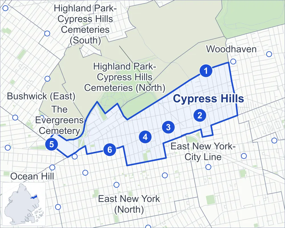
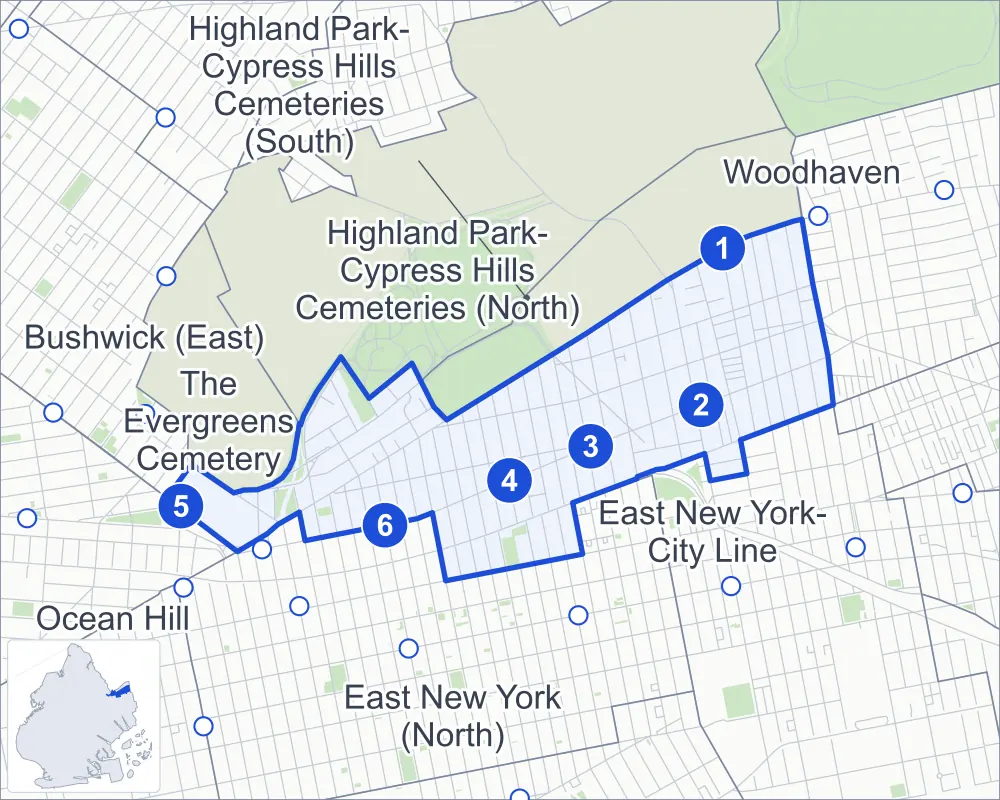
- Cypress Hills
- A neighboring area
- Park
- A station in the list
- Another station
Neighborhood areas and streets: NYC Department of City Planning. Parks: NYC Parks. Stations: MTA.
Neighboring areas
- Highland Park-Cypress Hills Cemeteries (South) northeast
- East New York-City Line east
- Woodhaven east
- East New York (North) southwest
- Highland Park-Cypress Hills Cemeteries (North) west
- The Evergreens Cemetery west
- Ocean Hill west
- Bushwick (East) west
Subway stations
- Cypress Hills lines J
- Crescent St lines J Z
- Norwood Av lines J Z
- Cleveland St lines J
- Broadway Junction lines L
- Van Siclen Av lines J Z
Getting around
Six subway stations and buses on 12 routes stop in or at the edge of Cypress Hills.
- 6 subway stations
- 12 local bus routes
Local bus routes
- B12
- B13
- B20
- B25
- B83
- J90
- Q7
- Q24
- Q56
- T340
- T430
- T434
Safety record
Between 2021 and 2025, its corners averaged more police-reported crashes than the average Brooklyn corner.
- 2,180 police-reported crashes at its corners
- 11.1 a corner, on average
- 10.5 the average Brooklyn corner
- 8 corners with a clean record
Signal or safety changes on City record, at 48 of its corners
- Leading pedestrian intervals
- 42
- Accessible pedestrian signals
- 10
- Turn calming
- 5
- Safety Improvement Projects
- 2
- Barnes Dance all-way crossings
- 1
Camera tickets
In 2025 its corners had more school-zone speed camera tickets than red-light or bus-lane tickets.
- 4,349 red-light camera tickets at two corners
- 35,953 school-zone speed camera tickets at five corners
- 0 bus-lane camera tickets
- Most red-light tickets
- Pennsylvania Avenue & Jamaica Avenue, 2,203
- Most speed tickets
- Euclid Avenue & Jamaica Avenue at Cypress Hills Street, 33,939
People and homes
The 2020 Census counted 43,256 residents in Cypress Hills, about 49,700 per square mile.
- 13,936 homes, 2020 Census
- 2,049 homes added since April 2010, net, by City Planning's count
Half of its 4,805 residential lots hold buildings from 1910 or earlier, and 95% of them date from before 1940, by the City's tax lot records.
Parks and landmarks
- Parkland
- 8.7 acres of NYC Parks property
- The largest pieces
- Highland Park (5.1 acres), Sperandeo Brothers Playground (2.8 acres) and George Walker Jr. Park (0.6 acre)
- Designated landmarks
- Public School 108 and Public School 65K
Streets and trees
- Trees
- 3,467 in NYC Parks' records, most often London planetree, Japanese flowering cherry and pin oak
- Street with the most corners
- Jamaica Avenue, with 39 of the area's 196
- Height above sea level
- From 24 feet at 93rd Avenue & Eldert Lane to 157 feet at Highland Boulevard & Heath Place
- Honorary street name
- 1 at its corners, enacted by local law
Schools and libraries
The City lists 18 schools and one library in Cypress Hills.
- Public schools
- 10
- Charter and private schools
- 8
- Library
- Arlington Library
Bike share
By the station list of October 3, 2026, eight bike-share stations stand in Cypress Hills.
- 8 bike-share stations
Public safety
How complaints are countedIn 2025 the NYPD recorded 421 major felonies at places in Cypress Hills.
Recorded by the NYPD at places in Cypress Hills
- 484 major felonies in 2024 63 fewer in 2025
- 1,406 other felonies, misdemeanors and violations in 2025
In 2025, on the streets along the edge of Cypress Hills, the NYPD recorded another 147 major felonies. Counting the streets along its edge, in 2025 the NYPD recorded 13.1 major felonies for every thousand residents the 2020 Census counted in Cypress Hills.
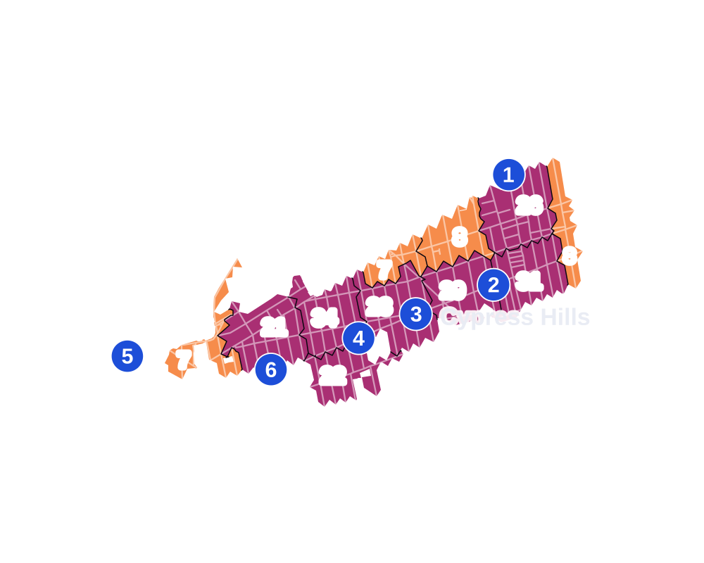
- 5 to 9
- 10 to 19
- 20 to 49
- 50 to 99
- 100 or more
- Not shaded: fewer than 5, held back under the rules in How complaints are counted, parks and public-housing grounds, and land in no patch
- Police precinct
- 75th
From January to June 2026 the NYPD recorded 242 major felonies at places in Cypress Hills, against 199 in the same months of 2025.
Sources: the NYPD's Complaint Data Historic, updated April 28, 2026, and Complaint Data Current (Year To Date), updated July 27, 2026, on NYC Open Data. Figures to June 30, 2026.
Street corners
- Arlington Avenue & Hale Avenue
- Arlington Avenue & Highland Place
- Ashford Street & Arlington Avenue
- Ashford Street & Ridgewood Avenue
- Atlantic Avenue & Autumn Avenue
- Atlantic Avenue & Berriman Street
- Atlantic Avenue & Chestnut Street
- Atlantic Avenue & Crescent Street
- Atlantic Avenue & Eldert Lane
- Atlantic Avenue & Elton Street
- Atlantic Avenue & Euclid Avenue
- Atlantic Avenue & Logan Street
- Atlantic Avenue & Warwick Street
- Autumn Avenue & Danforth Street
- Autumn Avenue & Etna Street
- Autumn Avenue & O'Brien Place
- Autumn Avenue & Ridgewood Avenue
- Barberry Court & Robert Street
- Barbey Street & Arlington Avenue
- Barbey Street & Highland Boulevard
- Barbey Street & Sunnyside Avenue
- Bradford Street & Arlington Avenue
- Broadway & East New York Avenue
- Broadway & Van Sinderen Avenue
- Bulwer Place & Crosby Avenue
- Bushwick Avenue & Fanchon Place
- Bushwick Avenue & Highland Boulevard
- Bushwick Avenue & Jackie Robinson Parkway
- Bushwick Avenue & Marginal Street West
- Chestnut Street & Dinsmore Place
- Chestnut Street & Etna Street
- Cleveland Street & Arlington Avenue
- Cleveland Street & Ridgewood Avenue
- Crescent Street & Adler Place
- Crescent Street & Campus Place
- Crescent Street & Cox Place
- Crescent Street & Cypress Court
- Crescent Street & Danforth Street
- Crescent Street & Etna Street
- Crescent Street & Kiely Place
- Crescent Street & Ridgewood Avenue
- Crescent Street & Weldon Street
- Crescent Street & Wharton Place
- Crosby Avenue & Miller Place
- Eldert Lane & Etna Street
- Eldert Lane & Karweg Place
- Elton Street & Arlington Avenue
- Elton Street & Jamaica Avenue
- Elton Street & Ridgewood Avenue
- Essex Street & Arlington Avenue
- Essex Street & Folsom Place
- Essex Street & Ridgewood Avenue
- Etna Street & Force Tube Avenue
- Etna Street & Hale Avenue
- Etna Street & Highland Place
- Etna Street & Nichols Avenue
- Etna Street & Norwood Avenue
- Etna Street & Richmond Street
- Euclid Avenue & Etna Street
- Euclid Avenue & Jamaica Avenue
- Euclid Avenue & Jamaica Avenue at Cypress Hills Street
- Euclid Avenue & Ridgewood Avenue
- Euclid Avenue & Solidarity Place
- Fulton Street & Arlington Avenue
- Fulton Street & Ashford Street
- Fulton Street & Autumn Avenue
- Fulton Street & Barbey Street
- Fulton Street & Chestnut Street
- Fulton Street & Cleveland Street
- Fulton Street & Crescent Street
- Fulton Street & Elton Street
- Fulton Street & Essex Street
- Fulton Street & Euclid Avenue
- Fulton Street & Force Tube Avenue
- Fulton Street & Grant Avenue
- Fulton Street & Hale Avenue
- Fulton Street & Hemlock Street
- Fulton Street & Hendrix Street
- Fulton Street & Highland Place
- Fulton Street & Jerome Street
- Fulton Street & Lincoln Avenue
- Fulton Street & Linwood Street
- Fulton Street & Logan Street
- Fulton Street & Nichols Avenue
- Fulton Street & Pine Street
- Fulton Street & Richmond Street
- Fulton Street & Shepherd Avenue
- Fulton Street & Vermont Street
- Fulton Street & Warwick Street
- Grant Avenue & Etna Street
- Grant Avenue & Karweg Place
- Grant Avenue & O'Brien Place
- Grant Avenue & Ridgewood Avenue
- Hale Avenue & Force Tube Avenue
- Hemlock Street & Adler Place
- Hemlock Street & Campus Place
- Hemlock Street & Danforth Street
- Hemlock Street & Etna Street
- Hemlock Street & Kiely Place
- Hemlock Street & Ridgewood Avenue
- Hendrix Street & Arlington Avenue
- Hendrix Street & Sunnyside Avenue
- Highland Boulevard & Barberry Court
- Highland Boulevard & Bulwer Place
- Highland Boulevard & Heath Place
- Highland Boulevard & J Robinson Parkway (north-east)
- Highland Boulevard & J Robinson Parkway (south-west)
- Highland Boulevard & Jackie Robinson Parkway
- Highland Boulevard & Jackie Robinson Parkway (Exit 1)
- Highland Boulevard & Marginal Street West
- Highland Boulevard & Robert Place
- Jackie Robinson Parkway & Bulwer Place
- Jackie Robinson Parkway & Crosby Avenue
- Jackie Robinson Parkway & Vermont Court
- Jamaica Avenue & Arlington Avenue
- Jamaica Avenue & Ashford Street
- Jamaica Avenue & Autumn Avenue
- Jamaica Avenue & Barbey Street
- Jamaica Avenue & Bradford Street
- Jamaica Avenue & Chestnut Street
- Jamaica Avenue & Cleveland Street
- Jamaica Avenue & Crescent Street
- Jamaica Avenue & Essex Street
- Jamaica Avenue & Georgia Avenue
- Jamaica Avenue & Grant Avenue
- Jamaica Avenue & Hale Avenue
- Jamaica Avenue & Hemlock Street
- Jamaica Avenue & Hendrix Street
- Jamaica Avenue & Highland Boulevard
- Jamaica Avenue & Jackie Robinson Parkway
- Jamaica Avenue & Jerome Street
- Jamaica Avenue & Lincoln Avenue
- Jamaica Avenue & Linwood Street
- Jamaica Avenue & Logan Street
- Jamaica Avenue & Miller Avenue
- Jamaica Avenue & New Jersey Avenue
- Jamaica Avenue & Nichols Avenue
- Jamaica Avenue & Norwood Avenue
- Jamaica Avenue & Richmond Street
- Jamaica Avenue & Ridgewood Avenue
- Jamaica Avenue & Schenck Avenue
- Jamaica Avenue & Schenck Court
- Jamaica Avenue & Shepherd Avenue
- Jamaica Avenue & Van Siclen Court
- Jamaica Avenue & Warwick Street
- Jamaica Avenue & Wyona Street
- Jerome Street & Arlington Avenue
- Liberty Avenue & Ashford Street
- Liberty Avenue & Berriman Street
- Liberty Avenue & Cleveland Street
- Liberty Avenue & Elton Street
- Liberty Avenue & Essex Street
- Liberty Avenue & Jerome Street
- Liberty Avenue & Shepherd Avenue
- Liberty Avenue & Warwick Street
- Lincoln Avenue & Etna Street
- Lincoln Avenue & O'Brien Place
- Lincoln Avenue & Ridgewood Avenue
- Linwood Street & Arlington Avenue
- Linwood Street & Folsom Place
- Linwood Street & Ridgewood Avenue
- Logan Street & Dinsmore Place
- Logan Street & Etna Street
- Logan Street & Force Tube Avenue
- Logan Street & Ridgewood Avenue
- Miller Avenue & Arlington Avenue
- Miller Avenue & Highland Boulevard
- Miller Avenue & Sunnyside Avenue
- Nichols Avenue & O'Brien Place
- Norwood Avenue & Force Tube Avenue
- Pennsylvania Avenue & Jamaica Avenue
- Pine Street & Etna Street
- Pine Street & Ridgewood Avenue
- Richmond Street & Dinsmore Place
- Ridgewood Avenue & Chestnut Street
- Ridgewood Avenue & Force Tube Avenue
- Ridgewood Avenue & Hale Avenue
- Ridgewood Avenue & Highland Place
- Ridgewood Avenue & Nichols Avenue
- Ridgewood Avenue & Norwood Avenue
- Ridgewood Avenue & Richmond Street
- Schenck Avenue & Arlington Avenue
- Shepherd Avenue & Arlington Avenue
- Shepherd Avenue & Ridgewood Avenue
- Sunnyside Avenue & Sunnyside Court
- Van Siclen Avenue & Arlington Avenue
- Van Siclen Avenue & Jamaica Avenue
- Vermont Street & Highland Boulevard
- Vermont Street & Highland Boulevard at Jackie Robinson Parkway
- Vermont Street & Jamaica Avenue
- Vermont Street & Sunnyside Avenue
- Warwick Street & Arlington Avenue
- Warwick Street & Ridgewood Avenue
How the figures above are measured: Methodology.