Woodhaven
Neighborhood · Queens
Woodhaven stretches along Jamaica Avenue in southwestern Queens, from Forest Park south to Atlantic Avenue, between Richmond Hill and Brooklyn's Cypress Hills.
- 0.85 square miles
- 41,948 residents, 2020 Census
- 185 street corners
- 3 subway stations
- 10 bus routes
Connecticut developer John R. Pitkin laid out its eastern part in 1835 as a workers' village called Woodville, and in 1853 residents switched to the name Woodhaven so it would not be mistaken for a place upstate. Even earlier, the Union Course, a racetrack opened in 1821 between 78th and 82nd Streets, staged match races between Northern and Southern horses before crowds of up to 70,000. Jamaica Avenue, which follows an old Native American trail, remains the main shopping street, beneath the elevated train.
Sources: Woodhaven, Queens (Wikipedia); Woodhaven (Queens Community Board 9).
Woodhaven borders five areas, and 91st Avenue and Jamaica Avenue hold more of its corners than any other street, 22 each of 187.
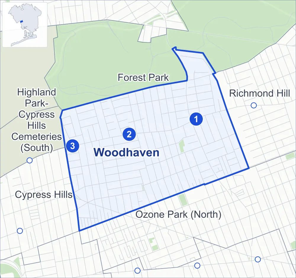
- Woodhaven
- A neighboring area
- Park
- A station in the list
- Another station
Neighborhood areas and streets: NYC Department of City Planning. Parks: NYC Parks. Stations: MTA.
Neighboring areas
- Forest Park north
- Richmond Hill east
- Ozone Park (North) south
- Cypress Hills southwest
- Highland Park-Cypress Hills Cemeteries (South) west
Subway stations
- Woodhaven Blvd lines J Z accessible
- 85 St-Forest Pkwy lines J
- 75 St-Elderts Ln lines J Z
Getting around
Three subway stations and buses on ten routes stop in or at the edge of Woodhaven.
- 3 subway stations
- 1 of them listed by the MTA as fully accessible
- 8 local bus routes
- 2 express bus routes
Local bus routes
- J90
- Q7
- Q11
- Q24
- Q52-SBS
- Q53-SBS
- Q56
- T340
Express bus routes
- BM5
- QM15
Safety record
Between 2021 and 2025, its corners averaged more police-reported crashes than the average Queens corner.
- 1,092 police-reported crashes at its corners
- 5.8 a corner, on average
- 5.2 the average Queens corner
- 25 corners with a clean record
Signal or safety changes on City record, at 28 of its corners
- Leading pedestrian intervals
- 24
- Accessible pedestrian signals
- 11
- Turn calming
- 2
- Barnes Dance all-way crossings
- 1
- Safety Improvement Projects
- 1
Camera tickets
In 2025 its corners had more bus-lane camera tickets than red-light or school-zone speed tickets.
- 2,663 red-light camera tickets at two corners
- 428 school-zone speed camera tickets at one corner
- 2,940 bus-lane camera tickets at two corners
- Most red-light tickets
- Woodhaven Boulevard & Atlantic Avenue, 1,744
- Most speed tickets
- 85th Drive & Forest Parkway, 428
- Most bus-lane tickets
- Jamaica Avenue & Woodhaven Boulevard, 1,916
People and homes
The 2020 Census counted 41,948 residents in Woodhaven, about 49,400 per square mile.
- 13,139 homes, 2020 Census
- 68 homes added since April 2010, net, by City Planning's count
Half of its 5,928 residential lots hold buildings from 1920 or earlier, and 93% of them date from before 1940, by the City's tax lot records.
Parks
- Parkland
- 2.8 acres of NYC Parks property
- The largest pieces
- Forest Park (1.4 acres) and Equity Playground (1.3 acres)
Streets and trees
- Trees
- 2,777 in NYC Parks' records, most often London planetree, pin oak and thornless honeylocust
- Street with the most corners
- 91st Avenue, with 22 of the area's 187
- Height above sea level
- From 23 feet at Fulton Street & Eldert Lane to 125 feet at Woodhaven Boulevard & Forest Park Drive
- Honorary street names
- 9 at its corners, enacted by local law
Schools and libraries
The City lists five schools and one library in Woodhaven.
- Public schools
- 4
- Charter or private school
- 1
- Library
- Woodhaven Library
Public safety
How complaints are countedIn 2025 the NYPD recorded 274 major felonies at places in Woodhaven.
Recorded by the NYPD at places in Woodhaven
- 264 major felonies in 2024
- 929 other felonies, misdemeanors and violations in 2025
In 2025, on the streets along the edge of Woodhaven, the NYPD recorded another 72 major felonies. Counting the streets along its edge, in 2025 the NYPD recorded 8.2 major felonies for every thousand residents the 2020 Census counted in Woodhaven.
- Police precinct
- 102nd
From January to June 2026 the NYPD recorded 136 major felonies at places in Woodhaven, against 129 in the same months of 2025.
Sources: the NYPD's Complaint Data Historic, updated April 28, 2026, and Complaint Data Current (Year To Date), updated July 27, 2026, on NYC Open Data. Figures to June 30, 2026.
Street corners
- 75th Street & 85th Drive
- 75th Street & 86th Road
- 75th Street & 87th Avenue
- 75th Street & 87th Road
- 75th Street & 88th Avenue
- 75th Street & 88th Road
- 75th Street & 93rd Avenue
- 76th Street & 85th Drive
- 76th Street & 85th Road
- 76th Street & 86th Avenue
- 76th Street & 86th Road
- 76th Street & 88th Avenue
- 76th Street & 93rd Avenue
- 76th Street & Atlantic Avenue
- 76th Street & Park Lane South
- 77th Street & 88th Avenue
- 78th Street & 86th Avenue
- 78th Street & 87th Avenue
- 78th Street & 87th Road
- 78th Street & 88th Avenue
- 78th Street & 88th Road
- 78th Street & 90th Avenue
- 78th Street & 90th Road
- 78th Street & 91st Avenue
- 79th Street & 85th Drive
- 79th Street & 85th Road
- 79th Street & 86th Avenue
- 79th Street & 91st Avenue
- 79th Street & Park Lane South
- 80th Street & 85th Avenue
- 80th Street & 85th Drive
- 80th Street & 85th Road
- 80th Street & 86th Avenue
- 80th Street & 86th Road
- 80th Street & 87th Avenue
- 80th Street & 87th Road
- 80th Street & 88th Avenue
- 80th Street & 88th Road
- 80th Street & 89th Avenue
- 80th Street & 90th Avenue
- 80th Street & 90th Road
- 80th Street & 91st Avenue
- 80th Street & Jamaica Avenue
- 80th Street & Park Lane South
- 80th Street & Rockaway Boulevard
- 82nd Street & Clemente Court
- 84th Street & 90th Road
- 85th Avenue & Forest Parkway
- 85th Drive & Dexter Court
- 85th Drive & Forest Parkway
- 85th Road & Forest Parkway
- 85th Street & 85th Avenue
- 85th Street & 85th Drive
- 85th Street & 85th Road
- 85th Street & 86th Avenue
- 85th Street & 87th Avenue
- 85th Street & 87th Road
- 85th Street & 88th Avenue
- 85th Street & 88th Road
- 85th Street & Park Lane South
- 86th Avenue & Forest Parkway
- 86th Road & Dexter Court
- 86th Road & Forest Parkway
- 86th Street & 85th Road
- 86th Street & 86th Avenue
- 86th Street & 88th Avenue
- 86th Street & Park Lane South
- 87th Road & Eldert Lane
- 87th Street & 85th Road
- 87th Street & 88th Avenue
- 87th Street & Atlantic Avenue
- 87th Street & Park Lane South
- 88th Road & 74th Place
- 88th Street & 85th Road
- 88th Street & 88th Avenue
- 88th Street & 91st Avenue
- 88th Street & Park Lane South
- 89th Avenue & 78th Street
- 89th Avenue & 84th Street
- 89th Avenue & 85th Street
- 89th Avenue & 86th Street
- 89th Avenue & 87th Street
- 89th Avenue & 88th Street
- 89th Avenue & 89th Street
- 89th Avenue & 90th Street
- 89th Avenue & 91st Street
- 89th Avenue & 92nd Street
- 89th Avenue & 94th Street
- 89th Avenue & 95th Street
- 89th Avenue & 96th Street
- 89th Avenue & 97th Street
- 89th Avenue & Woodhaven Boulevard
- 89th Street & 85th Road
- 89th Street & 86th Road
- 89th Street & 88th Avenue
- 89th Street & Park Lane South
- 90th Avenue & 74th Place
- 90th Avenue & 75th Street
- 90th Avenue & 76th Street
- 90th Avenue & 77th Street
- 90th Avenue & 84th Street
- 90th Avenue & 96th Street
- 90th Street & 85th Road
- 90th Street & 86th Road
- 90th Street & 88th Avenue
- 90th Street & Park Lane South
- 91st Avenue & 76th Street
- 91st Avenue & 77th Street
- 91st Avenue & 81st Street
- 91st Avenue & 82nd Street
- 91st Avenue & 85th Street
- 91st Avenue & 86th Street
- 91st Avenue & 87th Street
- 91st Avenue & 89th Street
- 91st Avenue & 90th Street
- 91st Avenue & 91st Street
- 91st Avenue & 92nd Street
- 91st Avenue & 95th Street
- 91st Avenue & 96th Street
- 91st Avenue & Woodhaven Boulevard
- 91st Street & 85th Avenue
- 91st Street & 85th Road
- 91st Street & 86th Avenue
- 91st Street & 86th Drive
- 91st Street & 86th Road
- 91st Street & Park Lane South
- 92nd Street & 88th Avenue
- 92nd Street & 92nd Avenue
- 92nd Street & 93rd Avenue
- 92nd Street & Atlantic Avenue
- 93rd Avenue & 74th Place
- 94th Street & 85th Avenue
- 94th Street & 85th Road
- 94th Street & 86th Avenue
- 94th Street & 86th Drive
- 94th Street & 86th Road
- 94th Street & Park Lane South
- 95th Street & 92nd Avenue
- 95th Street & 93rd Avenue
- 96th Street & 85th Avenue
- 96th Street & 85th Road
- 96th Street & 86th Avenue
- 96th Street & 86th Road
- 96th Street & 91st Drive
- 96th Street & 91st Road
- 96th Street & Atlantic Avenue
- 96th Street & Park Lane South
- 97th Street & 91st Avenue
- 97th Street & 91st Drive
- 97th Street & 91st Road
- 98th Street & 91st Avenue
- 98th Street & Park Lane South
- Forest Park Drive & Park Lane South
- Jamaica Avenue & 75th Street
- Jamaica Avenue & 76th Street
- Jamaica Avenue & 77th Street
- Jamaica Avenue & 78th Street
- Jamaica Avenue & 79th Street
- Jamaica Avenue & 85th Street
- Jamaica Avenue & 86th Street
- Jamaica Avenue & 87th Street
- Jamaica Avenue & 88th Street
- Jamaica Avenue & 89th Street
- Jamaica Avenue & 90th Street
- Jamaica Avenue & 91st Street
- Jamaica Avenue & 92nd Street
- Jamaica Avenue & 94th Street
- Jamaica Avenue & 95th Street
- Jamaica Avenue & 96th Street
- Jamaica Avenue & 97th Street
- Jamaica Avenue & Dexter Court
- Jamaica Avenue & Forest Parkway
- Jamaica Avenue & Woodhaven Boulevard
- Rockaway Boulevard & 76th Street
- Rockaway Boulevard & 77th Street
- Rockaway Boulevard & 78th Street
- Rockaway Boulevard & 79th Street
- Rockaway Boulevard & 90th Avenue
- Rockaway Boulevard & 91st Avenue
- Rockaway Boulevard & Eldert Lane
- Woodhaven Boulevard & 85th Road
- Woodhaven Boulevard & 86th Road
- Woodhaven Boulevard & Atlantic Avenue
- Woodhaven Boulevard & Forest Park Drive
- Woodhaven Boulevard & Park Lane South
How the figures above are measured: Methodology.