Forest Park
Park · Queens
Forest Park covers 543 acres of Queens, bordered by Kew Gardens, Richmond Hill, Woodhaven, Glendale and Forest Hills, and about three-quarters of it is woodland.
- 0.86 square miles
- 10 street corners
- 10 bus routes
Its hills and hollows, including the kettle known as Strack Pond, were shaped by the last glacier along the Harbor Hill Moraine. The land, assembled by the City of Brooklyn in the 1890s, was first known as Brooklyn Forest Park, and the landscape firm Olmsted, Olmsted & Eliot planned its winding main drive. Run today by NYC Parks, it is known for its oak and hickory forest, hiking and bridle trails, a carousel, a bandshell and a golf course.
Sources: Forest Park (Queens) (Wikipedia); Forest Park - NY (The Cultural Landscape Foundation).
Forest Park borders six areas, and Forest Park Drive holds more of its corners than any other street, eight of 10.
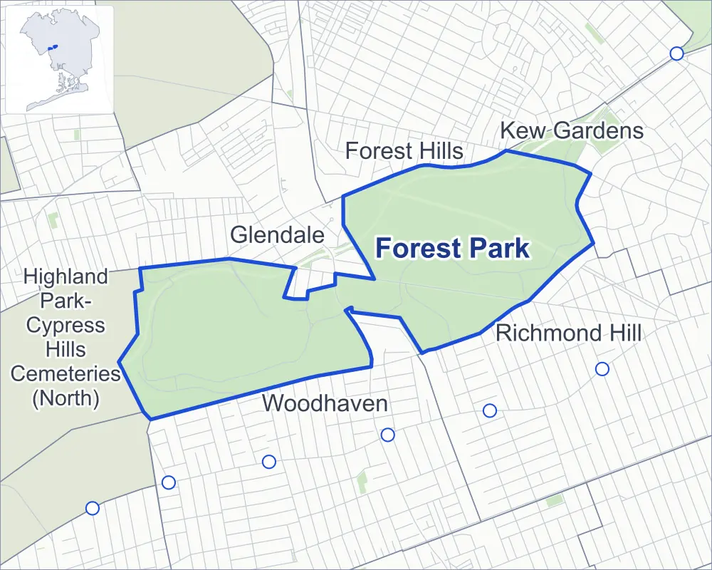
- Forest Park
- A neighboring area
- Park
- Another station
Neighborhood areas and streets: NYC Department of City Planning. Parks: NYC Parks. Stations: MTA.
Neighboring areas
- Forest Hills northeast
- Kew Gardens northeast
- Richmond Hill east
- Woodhaven southwest
- Glendale west
- Highland Park-Cypress Hills Cemeteries (North) west
Getting around
Buses on ten routes stop in or at the edge of Forest Park.
- 8 local bus routes
- 2 express bus routes
Local bus routes
- Q11
- Q23
- Q29
- Q37
- Q52-SBS
- Q53-SBS
- Q54
- Q55
Express bus routes
- BM5
- QM15
Safety record
Between 2021 and 2025, its corners averaged more police-reported crashes than the average Queens corner.
- 54 police-reported crashes at its corners
- 5.4 a corner, on average
- 5.2 the average Queens corner
- 6 corners with a clean record
Camera tickets
In 2025 the Department of Finance recorded no red-light, school-zone speed or bus-lane camera ticket at its corners.
Parks
- Parkland
- 486.3 acres of Forest Park, as NYC Parks maps it within the area's boundary
Streets and trees
- Trees
- 1,874 in NYC Parks' records, most often pin oak, northern red oak and oak
- Street with the most corners
- Forest Park Drive, with eight of the area's 10
- Height above sea level
- From 95 feet at Forest Park Drive & Jackie Robinson Parkway to 131 feet at Forest Park Drive & Jackie Robinson Parkway
Public art
The City's public art inventory lists two works in Forest Park: Richmond Hill War Memorial (1925) and Sergeant Joseph E. Schaefer Memorial (1987).
- 2 works of public art
Street corners
- Forest Park Drive & J Robinson Parkway (north)
- Forest Park Drive & J Robinson Parkway (south)
- Forest Park Drive & Jackie Robinson Parkway (Exit 4, north)
- Forest Park Drive & Jackie Robinson Parkway (Exit 4, south)
- Forest Park Drive & Jackie Robinson Parkway (Exit 5)
- Forest Park Drive & Memorial Drive
- Jackie Robinson Parkway & Forest Park Drive (north-east)
- Jackie Robinson Parkway & Forest Park Drive (south-west)
- Jackie Robinson Parkway & Forest Park Greenway
- Myrtle Avenue & Freedom Drive
How the figures above are measured: Methodology.