Forest Hills
Neighborhood · Queens
Forest Hills lies in central Queens along Queens Boulevard, with Rego Park to the west and Forest Park to the south, and includes the planned enclave of Forest Hills Gardens.
- 2.08 square miles
- 88,965 residents, 2020 Census
- 439 street corners
- 4 subway stations
- 26 bus routes
A developer bought the land in 1906 and named it for nearby Forest Park, and the Russell Sage Foundation, founded in 1907, built Forest Hills Gardens as a model suburban community whose houses, by architect Grosvenor Atterbury, were mostly finished between 1910 and 1917. Its 1923 tennis stadium hosted the national championships that became the U.S. Open, and after the subway arrived in 1936 the population reached 32,500 by 1940.
Sources: Forest Hills, Queens (Wikipedia); Foundation History (Russell Sage Foundation).
Forest Hills borders six areas, and Yellowstone Boulevard holds more of its corners than any other street, 37 of 439.
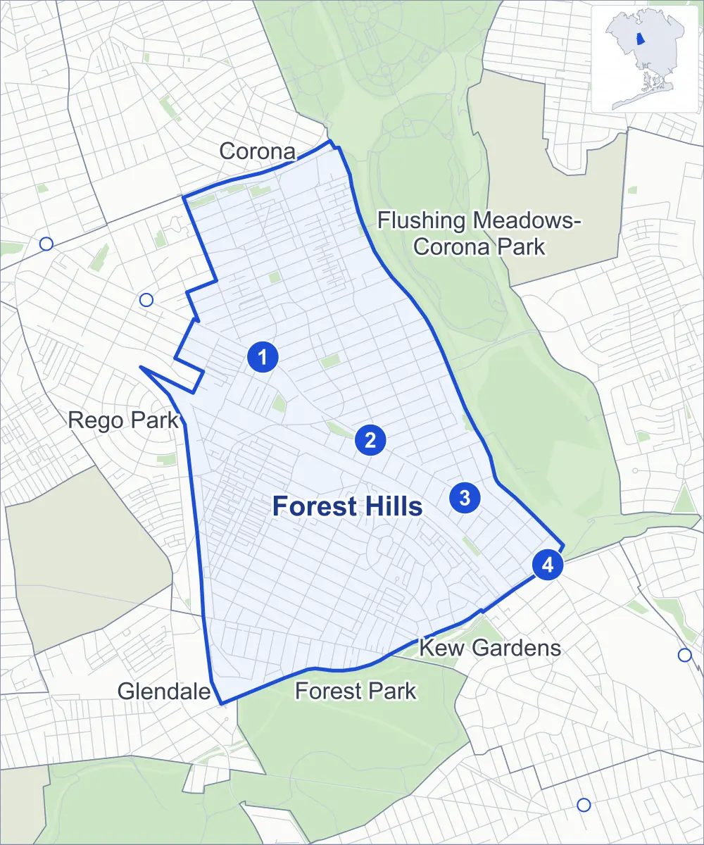
- Forest Hills
- A neighboring area
- Park
- A station in the list
- Another station
Neighborhood areas and streets: NYC Department of City Planning. Parks: NYC Parks. Stations: MTA.
Neighboring areas
- Corona north
- Flushing Meadows-Corona Park northeast
- Kew Gardens southeast
- Forest Park south
- Glendale southwest
- Rego Park west
Subway stations
- 67 Av lines M R
- Forest Hills-71 Av lines E F M R accessible
- 75 Av lines E F
- Kew Gardens-Union Tpke lines E F accessible
Getting around
Four subway stations and buses on 26 routes stop in or at the edge of Forest Hills.
- 4 subway stations
- 2 of them listed by the MTA as fully accessible
- 14 local bus routes
- 12 express bus routes
Local bus routes
- Q23
- Q37
- Q38
- Q45
- Q46
- Q48
- Q54
- Q58
- Q60
- Q64
- Q74
- Q88
- Q98
- T300
Express bus routes
- QM4
- QM10
- QM11
- QM12
- QM18
- QM40
- QM42
- QM44
- QM63
- QM64
- QM65
- QM68
Safety record
Between 2021 and 2025, its corners averaged fewer police-reported crashes than the average Queens corner.
- 1,968 police-reported crashes at its corners
- 4.5 a corner, on average
- 5.2 the average Queens corner
- 99 corners with a clean record
Signal or safety changes on City record, at 80 of its corners
- Leading pedestrian intervals
- 63
- Accessible pedestrian signals
- 23
- Turn calming
- 9
- Safety Improvement Projects
- 7
- Barnes Dance all-way crossings
- 3
- Enhanced crossings
- 3
Camera tickets
In 2025 its corners had more school-zone speed camera tickets than red-light or bus-lane tickets.
- 11,984 red-light camera tickets at three corners
- 15,262 school-zone speed camera tickets at eight corners
- 0 bus-lane camera tickets
- Most red-light tickets
- Grand Central Parkway & 72nd Road, 7,834
- Most speed tickets
- Queens Boulevard & 77th Avenue, 9,125
People and homes
The 2020 Census counted 88,965 residents in Forest Hills, about 42,800 per square mile.
- 42,353 homes, 2020 Census
- 1,582 homes added since April 2010, net, by City Planning's count
Half of its 7,085 residential lots hold buildings from 1935 or earlier, and 54% of them date from before 1940, by the City's tax lot records.
Parks and landmarks
- Parkland
- 13.4 acres of NYC Parks property
- The largest pieces
- MacDonald Park (1.9 acres), Yellowstone Park (1.8 acres) and Real Good Playground (1.6 acres)
- Designated landmarks
- The Ridgewood Savings Bank; and the Firehouse, Engine Company 305 and Hook & Ladder 151
Streets and trees
- Trees
- 8,154 in NYC Parks' records, most often London planetree, pin oak and thornless honeylocust
- Street with the most corners
- Yellowstone Boulevard, with 37 of the area's 439
- Height above sea level
- From 10 feet at Grand Central Parkway & 63rd Avenue to 118 feet at Union Turnpike & Greenway North
- Honorary street names
- 19 at its corners, enacted by local law
Schools and libraries
The City lists 21 schools and two libraries in Forest Hills.
- Public schools
- 13
- Charter and private schools
- 8
- Libraries
- Forest Hills Library and North Forest Park Library
Bike share and public art
By the station list of October 3, 2026, 37 bike-share stations stand in Forest Hills. The City's public art inventory lists one work in the area: Gerald MacDonald (1934).
- 37 bike-share stations
- 1 work of public art
Public safety
How complaints are countedIn 2025 the NYPD recorded 617 major felonies at places in Forest Hills.
Recorded by the NYPD at places in Forest Hills
- 584 major felonies in 2024
- 2,785 other felonies, misdemeanors and violations in 2025
In 2025, on the streets along the edge of Forest Hills, the NYPD recorded another 57 major felonies. Counting the streets along its edge, in 2025 the NYPD recorded 7.6 major felonies for every thousand residents the 2020 Census counted in Forest Hills.
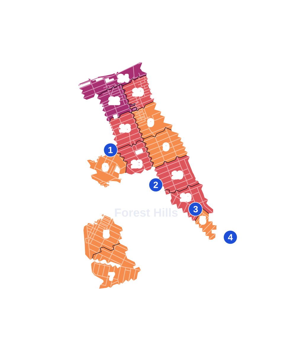
- 5 to 9
- 10 to 19
- 20 to 49
- 50 to 99
- 100 or more
- Not shaded: fewer than 5, held back under the rules in How complaints are counted, parks and public-housing grounds, and land in no patch
- Police precincts
- 112th (most of the area), 102nd
From January to June 2026 the NYPD recorded 337 major felonies at places in Forest Hills, against 280 in the same months of 2025.
Sources: the NYPD's Complaint Data Historic, updated April 28, 2026, and Complaint Data Current (Year To Date), updated July 27, 2026, on NYC Open Data. Figures to June 30, 2026.
Street corners
- 62nd Avenue & Apex Place
- 62nd Avenue & Colonial Avenue
- 62nd Avenue & Colonial Avenue Pedestrian Overpass
- 62nd Avenue & Yellowstone Boulevard
- 62nd Drive & Apex Place
- 62nd Drive & Colonial Avenue
- 63rd Avenue & Apex Place
- 63rd Avenue & Yellowstone Boulevard
- 63rd Road & Apex Place
- 64th Avenue & Yellowstone Boulevard
- 65th Avenue & Yellowstone Boulevard
- 65th Road & Saunders Street
- 66th Avenue & Booth Street
- 66th Avenue & Saunders Street
- 66th Avenue & Wetherole Street
- 67th Avenue & 67th Avenue Footbridge
- 67th Avenue & 110th Street
- 67th Avenue & Austin Street
- 67th Avenue & Booth Street
- 67th Avenue & Burns Street
- 67th Avenue & Clyde Street
- 67th Avenue & Dartmouth Street
- 67th Avenue & Saunders Street
- 67th Avenue & Thornton Place
- 67th Avenue & Wetherole Street
- 67th Avenue & Yellowstone Boulevard
- 67th Drive & Booth Street
- 67th Road & Booth Street
- 68th Avenue & Booth Street
- 68th Avenue & Burns Street
- 68th Avenue & Clyde Street
- 68th Avenue & Dartmouth Street
- 68th Avenue & Exeter Street
- 68th Avenue & Fleet Street
- 68th Avenue & Groton Street
- 68th Avenue & Harrow Street
- 68th Avenue & Ingram Street
- 68th Avenue & Juno Street
- 68th Avenue & Kessel Street
- 68th Avenue & Loubet Street
- 68th Avenue & Manse Street
- 68th Avenue & Selfridge Street
- 68th Avenue & Yellowstone Boulevard
- 69th Avenue & 108th Street
- 69th Avenue & 110th Street
- 69th Avenue & 112th Street
- 69th Avenue & Burns Street
- 69th Avenue & Clyde Street
- 69th Avenue & Dartmouth Street
- 69th Avenue & Exeter Street
- 69th Avenue & Fleet Street
- 69th Avenue & Groton Street
- 69th Avenue & Harrow Street
- 69th Avenue & Ingram Street
- 69th Avenue & Juno Street
- 69th Avenue & Kessel Street
- 69th Avenue & Loubet Street
- 69th Avenue & Manse Street
- 69th Avenue & Nansen Street
- 69th Avenue & Olcott Street
- 69th Avenue & Yellowstone Boulevard
- 69th Road & Gerard Place
- 69th Road & Olcott Street
- 69th Road & Sybilla Street
- 70th Avenue & Dartmouth Street
- 70th Avenue & Exeter Street
- 70th Avenue & Fleet Street
- 70th Avenue & Groton Street
- 70th Avenue & Harrow Street
- 70th Avenue & Ingram Street
- 70th Avenue & Juno Street
- 70th Avenue & Kessel Street
- 70th Avenue & Loubet Street
- 70th Avenue & Manse Street
- 70th Avenue & Nansen Street
- 70th Avenue & Olcott Street
- 70th Avenue & Sybilla Street
- 70th Road & Sybilla Street
- 71st Avenue & 110th Street
- 71st Avenue & 112th Street
- 71st Avenue & 113th Street
- 71st Avenue & Austin Street
- 71st Avenue & Continental Avenue
- 71st Avenue & Groton Street
- 71st Avenue & Harrow Street
- 71st Avenue & Ingram Street
- 71st Avenue & Juno Street
- 71st Avenue & Kessel Street
- 71st Avenue & Loubet Street
- 71st Avenue & Manse Street
- 71st Avenue & Nansen Street
- 71st Avenue & Olcott Street
- 71st Avenue & Sybilla Street
- 71st Avenue & Walnut Street
- 71st Road & Bow Street
- 71st Road & Bow Street at Middlemay Place
- 71st Road & Slocum Crescent
- 72nd Avenue & Harrow Street
- 72nd Avenue & Ingram Street
- 72nd Avenue & Juno Street
- 72nd Avenue & Kessel Street
- 72nd Avenue & Loubet Street
- 72nd Avenue & Manse Street
- 72nd Avenue & Nansen Street
- 72nd Avenue & Roman Avenue
- 72nd Road & Manse Street
- 72nd Road & Russell Place
- 72nd Road & Slocum Crescent
- 73rd Avenue & 112th Street
- 74th Avenue & Kessel Street
- 75th Avenue & 112th Street
- 75th Avenue & 113th Street
- 75th Avenue & Austin Street
- 75th Avenue & Beechknoll Road
- 75th Avenue & Burns Street
- 75th Avenue & Kessel Street
- 75th Road & Kessel Street
- 77th Avenue & 113th Street
- 77th Avenue & Austin Street
- 77th Avenue & Kew Forest Lane
- 77th Road & Kew Forest Lane
- 78th Avenue & 113th Street
- 78th Avenue & Kew Forest Lane
- 98th Street & 64th Road
- 99th Street & 62nd Avenue
- 99th Street & 62nd Road
- 99th Street & 63rd Avenue
- 99th Street & 64th Avenue
- 99th Street & 64th Road
- 99th Street & 65th Avenue
- 99th Street & 65th Road
- 99th Street & 66th Avenue
- 99th Street & 66th Road
- 102nd Street & 62nd Avenue
- 102nd Street & 62nd Drive
- 102nd Street & 62nd Road
- 102nd Street & 63rd Avenue
- 102nd Street & 63rd Drive
- 102nd Street & 63rd Road
- 102nd Street & 64th Avenue
- 102nd Street & 64th Road
- 102nd Street & 65th Avenue
- 102nd Street & 65th Road
- 102nd Street & 66th Avenue
- 102nd Street & 66th Road
- 102nd Street & 67th Avenue
- 102nd Street & 67th Road
- 103rd Street & 66th Avenue
- 103rd Street & 66th Road
- 108th Street & 62nd Avenue
- 108th Street & 62nd Drive
- 108th Street & 62nd Road
- 108th Street & 63rd Avenue
- 108th Street & 63rd Drive
- 108th Street & 63rd Road
- 108th Street & 64th Avenue
- 108th Street & 64th Road
- 108th Street & 65th Avenue
- 108th Street & 65th Road
- 108th Street & 66th Avenue
- 108th Street & 66th Road
- 108th Street & 67th Avenue
- 108th Street & 67th Drive
- 108th Street & 67th Road
- 108th Street & 68th Avenue
- 108th Street & 68th Drive
- 108th Street & 68th Road
- 108th Street & 69th Road
- 108th Street & 70th Avenue
- 108th Street & 70th Road
- 108th Street & 71st Avenue
- 108th Street & Apex Place
- 108th Street & Jewel Avenue
- 110th Street & 62nd Drive
- 110th Street & 63rd Avenue
- 110th Street & 63rd Drive
- 110th Street & 63rd Road
- 110th Street & 64th Avenue
- 110th Street & 64th Road
- 110th Street & 65th Avenue
- 110th Street & 65th Road
- 110th Street & 66th Avenue
- 110th Street & 66th Road
- 110th Street & 67th Drive
- 110th Street & 67th Road
- 110th Street & 68th Avenue
- 110th Street & 68th Drive
- 110th Street & 68th Road
- 110th Street & 69th Road
- 110th Street & 70th Avenue
- 110th Street & 70th Road
- 110th Street & 71st Road
- 110th Street & 72nd Avenue
- 110th Street & 72nd Road
- 110th Street & Jewel Avenue
- 111th Street & 66th Road
- 112th Street & 67th Drive
- 112th Street & 67th Road
- 112th Street & 68th Avenue
- 112th Street & 68th Drive
- 112th Street & 68th Road
- 112th Street & 69th Road
- 112th Street & 70th Avenue
- 112th Street & 70th Road
- 112th Street & 71st Road
- 112th Street & 72nd Avenue
- 112th Street & 72nd Drive
- 112th Street & 72nd Road
- 112th Street & Jewel Avenue
- 113th Street & 70th Road
- 113th Street & 71st Road
- 113th Street & 72nd Drive
- 113th Street & 72nd Road
- 113th Street & 76th Road
- 113th Street & Jewel Avenue
- Ascan Avenue & Greenway North
- Ascan Avenue & Greenway South
- Ascan Avenue & Ingram Street
- Ascan Avenue & Loubet Street
- Ascan Avenue & Manse Street
- Ascan Avenue & Russell Place
- Ascan Avenue & Seasongood Road
- Ascan Avenue & Standish Road
- Ascan Avenue & Whitson Street
- Ascan Avenue & Winter Street
- Austin Street & 66th Avenue
- Austin Street & 67th Drive
- Austin Street & 67th Road
- Austin Street & 68th Avenue
- Austin Street & 69th Road
- Austin Street & 70th Avenue
- Austin Street & 70th Road
- Austin Street & 71st Road
- Austin Street & 72nd Avenue
- Austin Street & 72nd Road
- Austin Street & 73rd Road
- Austin Street & 75th Road
- Austin Street & 76th Avenue
- Austin Street & 76th Drive
- Austin Street & 76th Road
- Austin Street & 77th Road
- Austin Street & Ascan Avenue
- Austin Street & Yellowstone Boulevard
- Beechknoll Road & Borage Place
- Beechknoll Road & Overhill Road
- Booth Street & 65th Road
- Booth Street & 68th Drive
- Burns Street & Ascan Avenue
- Burns Street & Borage Place
- Burns Street & Bye Street
- Burns Street & Continental Avenue
- Burns Street & Greenway Terrace
- Burns Street & Overhill Road
- Burns Street & Puritan Avenue
- Burns Street & Slocum Crescent
- Burns Street & Tennis Place
- Burns Street & Thornton Place
- Burns Street & Underwood Road
- Burns Street & Upshaw Road
- Burns Street & Yellowstone Boulevard
- Clyde Street & Thornton Place
- Continental Avenue & Archway Place
- Continental Avenue & Bow Street
- Continental Avenue & Station Square
- Cranford Street & Russell Place
- Dartmouth Street & Continental Avenue
- Dartmouth Street & Tennis Place
- Dartmouth Street & Thornton Place
- Exeter Street & Dane Place
- Exeter Street & Tennis Place
- Exeter Street & Thornton Place
- Fleet Street & Continental Avenue
- Fleet Street & Dane Place
- Fleet Street & Selfridge Street
- Fleet Street & Thornton Place
- Grand Central Parkway & 62nd Avenue
- Grand Central Parkway & 62nd Drive
- Grand Central Parkway & 63rd Avenue
- Grand Central Parkway & 63rd Drive
- Grand Central Parkway & 63rd Road
- Grand Central Parkway & 64th Avenue
- Grand Central Parkway & 64th Road
- Grand Central Parkway & 65th Avenue
- Grand Central Parkway & 66th Avenue
- Grand Central Parkway & 66th Road
- Grand Central Parkway & 67th Road
- Grand Central Parkway & 68th Avenue
- Grand Central Parkway & 68th Drive
- Grand Central Parkway & 68th Road
- Grand Central Parkway & 69th Avenue
- Grand Central Parkway & 72nd Road
- Grand Central Parkway & 72nd Road Pedestrian Overpass
- Grand Central Parkway & 75th Avenue
- Grand Central Parkway & 76th Road
- Grand Central Parkway & 77th Avenue
- Grand Central Parkway & 78th Avenue
- Grand Central Parkway & 78th Crescent
- Greenway North & Borage Place
- Greenway North & Goodwood Road
- Greenway North & Markwood Place
- Greenway North & Overhill Road
- Greenway North & Puritan Avenue
- Greenway North & Rockrose Place
- Greenway North & Underwood Road
- Greenway North & Wendover Road
- Greenway South & Fairway Close
- Greenway South & Greenway Terrace
- Greenway South & Harrow Street
- Greenway South & Norden Road
- Greenway South & Olive Place
- Greenway South & Puritan Avenue
- Greenway South & Rockrose Place
- Greenway South & Roman Avenue
- Greenway South & Shorthill Road
- Greenway South & Summer Street
- Greenway Terrace & Archway Place
- Greenway Terrace & Greenway Circle (east)
- Greenway Terrace & Greenway Circle (west)
- Greenway Terrace & Greenway North
- Greenway Terrace & Middlemay Circle
- Greenway Terrace & Middlemay Circle at Middlemay Place
- Greenway Terrace & Station Square
- Groton Street & Fleet Street
- Groton Street & Roman Avenue
- Groton Street & Selfridge Street
- Horace Harding Expressway & 62nd Avenue
- Horace Harding Expressway & 99th Street Pedestrian Overpass
- Horace Harding Expressway & 102nd Street
- Horace Harding Expressway & Long Island Expressway
- Horace Harding Expressway & Yellowstone Boulevard
- Ingram Street & Puritan Avenue
- Ingram Street & Selfridge Street
- Jackie Robinson Parkway & Austin Street
- Jackie Robinson Parkway & Kew Gardens Road
- Jackie Robinson Parkway & Park Lane
- Jewel Avenue & Yellowstone Boulevard
- Juno Street & Selfridge Street
- Kessel Street & Ascan Avenue
- Kessel Street & Selfridge Street
- Kessel Street & Whitson Street
- Long Island Expressway & 99th Street Pedestrian Overpass
- Long Island Expressway & 108th Street
- Long Island Expressway & Colonial Avenue Pedestrian Overpass
- Markwood Place & Upshaw Road
- Metropolitan Avenue & 69th Avenue
- Metropolitan Avenue & 69th Road
- Metropolitan Avenue & 70th Avenue
- Metropolitan Avenue & 70th Drive
- Metropolitan Avenue & 70th Road
- Metropolitan Avenue & 71st Avenue
- Metropolitan Avenue & 71st Drive
- Metropolitan Avenue & 71st Road
- Metropolitan Avenue & 72nd Avenue
- Metropolitan Avenue & 72nd Drive
- Metropolitan Avenue & 72nd Road
- Metropolitan Avenue & 74th Avenue
- Metropolitan Avenue & 75th Avenue
- Metropolitan Avenue & 75th Road
- Metropolitan Avenue & Ascan Avenue
- Metropolitan Avenue & Queens Metropolitan High School Driveway
- Metropolitan Avenue & Selfridge Street
- Middlemay Circle & Bye Street
- Middlemay Circle & Holder Place
- Puritan Avenue & Beechknoll Road
- Puritan Avenue & Seasongood Road
- Puritan Avenue & Shorthill Road
- Queens Boulevard & 67th Avenue
- Queens Boulevard & 67th Road
- Queens Boulevard & 69th Road
- Queens Boulevard & 70th Avenue
- Queens Boulevard & 70th Road
- Queens Boulevard & 71st Avenue
- Queens Boulevard & 71st Road
- Queens Boulevard & 75th Avenue
- Queens Boulevard & 76th Road
- Queens Boulevard & 77th Avenue
- Queens Boulevard & 78th Avenue
- Queens Boulevard & Ascan Avenue
- Queens Boulevard & Yellowstone Boulevard
- Rockrose Place & Markwood Place
- Rockrose Place & Wendover Road
- Russell Place & Childrens Lane
- Seasongood Road & Ivy Close
- Seasongood Road & Summer Street
- Selfridge Street & Loubet Street
- Selfridge Street & Manse Street
- Selfridge Street & Nansen Street
- Selfridge Street & Olcott Street
- Shorthill Road & Goodwood Road
- Slocum Crescent & Exeter Street
- Slocum Crescent & Holder Place
- Slocum Crescent & Standish Road
- Standish Road & Childrens Lane
- Summer Street & Winter Street
- Sybilla Street & 70th Drive
- Underwood Road & Deepdene Road
- Union Turnpike & 71st Avenue
- Union Turnpike & 72nd Avenue
- Union Turnpike & 72nd Drive
- Union Turnpike & 75th Road
- Union Turnpike & Burns Street
- Union Turnpike & Greenway North
- Union Turnpike & Greenway South
- Union Turnpike & Kessel Street
- Union Turnpike & Kew Forest Lane
- Union Turnpike & Metropolitan Avenue
- Union Turnpike & Union Turnpike Pedestrian and Bike Path
- Upshaw Road & Deepdene Road
- Ursula Place & Queens Metropolitan High School Driveway
- Walnut Street & 70th Drive
- Wetherole Street & 65th Road
- Whitson Street & Norden Road
- Whitson Street & Puritan Avenue
- Winter Street & Ivy Close
- Yellowstone Boulevard & 62nd Drive
- Yellowstone Boulevard & 62nd Road
- Yellowstone Boulevard & 63rd Drive
- Yellowstone Boulevard & 63rd Road
- Yellowstone Boulevard & 64th Road
- Yellowstone Boulevard & 65th Road
- Yellowstone Boulevard & 66th Avenue
- Yellowstone Boulevard & 66th Road
- Yellowstone Boulevard & 67th Drive
- Yellowstone Boulevard & 67th Road
- Yellowstone Boulevard & 68th Drive
- Yellowstone Boulevard & 68th Road
- Yellowstone Boulevard & 69th Road
- Yellowstone Boulevard & Apex Place
- Yellowstone Boulevard & Clyde Street
- Yellowstone Boulevard & Dane Place
- Yellowstone Boulevard & Dartmouth Street
- Yellowstone Boulevard & Exeter Street
- Yellowstone Boulevard & Fleet Street
- Yellowstone Boulevard & Gerard Place
- Yellowstone Boulevard & Groton Street
- Yellowstone Boulevard & Harrow Street
- Yellowstone Boulevard & Ingram Street
- Yellowstone Boulevard & Juno Street
- Yellowstone Boulevard & Selfridge Street
How the figures above are measured: Methodology.