Flushing Meadows-Corona Park
Park · Queens
Flushing Meadows-Corona Park stretches through northern Queens along the Flushing River and is the largest park in the borough.
- 1.98 square miles
- 153 street corners
- 2 subway stations
- 15 bus routes
In the early 1900s its marshes became an ash dump made famous by The Great Gatsby, until the site was rebuilt for the 1939 World's Fair; a second fair followed in 1964, and the park opened in its present form in 1967. Run by NYC Parks, it is known for the Unisphere, the Queens Museum in a 1939 fair building that housed the United Nations from 1946 to 1950, the Queens Zoo and the tennis center that hosts the U.S. Open.
Sources: Flushing Meadows–Corona Park (Wikipedia); Flushing Meadows Corona Park (The Cultural Landscape Foundation); About (Queens Museum).
Flushing Meadows-Corona Park borders ten areas, and Van Wyck Expressway holds more of its corners than any other street, 35 of 153.
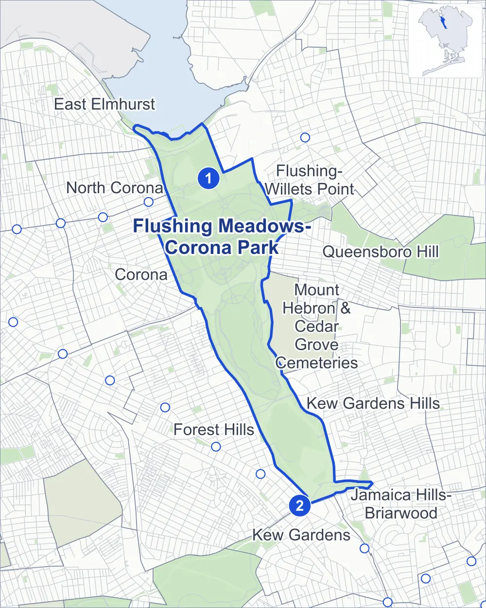
- Flushing Meadows-Corona Park
- A neighboring area
- Park
- A station in the list
- Another station
Neighborhood areas and streets: NYC Department of City Planning. Parks: NYC Parks. Stations: MTA.
Neighboring areas
- Flushing-Willets Point north
- Queensboro Hill northeast
- Kew Gardens Hills southeast
- Mount Hebron & Cedar Grove Cemeteries southeast
- Jamaica Hills-Briarwood southeast
- Forest Hills south
- Kew Gardens south
- Corona northwest
- East Elmhurst northwest
- North Corona northwest
Subway stations
- Mets-Willets Point lines 7
- Kew Gardens-Union Tpke lines E F accessible
Getting around
Two subway stations and buses on 15 routes stop in or at the edge of Flushing Meadows-Corona Park.
- 2 subway stations
- 1 of them listed by the MTA as fully accessible
- 10 local bus routes
- 5 express bus routes
Local bus routes
- Q37
- Q45
- Q46
- Q48
- Q58
- Q60
- Q64
- Q90
- Q98
- T321
Express bus routes
- QM18
- QM63
- QM64
- QM65
- QM68
Safety record
Between 2021 and 2025, its corners averaged fewer police-reported crashes than the average Queens corner.
- 270 police-reported crashes at its corners
- 1.8 a corner, on average
- 5.2 the average Queens corner
- 119 corners with a clean record
Signal or safety changes on City record, at two of its corners
- Accessible pedestrian signals
- 1
- Safety Improvement Projects
- 1
Camera tickets
In 2025 its corners had more red-light camera tickets than school-zone speed or bus-lane tickets.
- 2,804 red-light camera tickets at one corner
- 0 school-zone speed camera tickets
- 0 bus-lane camera tickets
- Most red-light tickets
- Long Island Expressway & College Point Boulevard, 2,804
Parks and landmarks
- Parkland
- 813.9 acres of Flushing Meadows Corona Park, as NYC Parks maps it within the area's boundary
- Designated landmark
- The Unisphere
Streets and trees
- Trees
- 9,991 in NYC Parks' records, most often pin oak, London planetree and eastern white pine
- Street with the most corners
- Van Wyck Expressway, with 35 of the area's 153
- Height above sea level
- From 3 feet at Fountain of the Planets Pr & Path of Research to 32 feet at United Nations Avenue South & Carousel Loop
Bike share and public art
By the station list of October 3, 2026, six bike-share stations stand in Flushing Meadows-Corona Park. The City's public art inventory lists 12 works in the area, among them New York State Marine Amphitheater Bas-Reliefs (1939), Column of Jerash (1964) and Forms in Transit (1964).
- 6 bike-share stations
- 12 works of public art
Street corners
- 69th Road & Grand Central Parkway
- 69th Road & Grand Central Parkway (Exit 11W)
- 69th Road & Van Wyck Expressway
- Avenue of Enterprise & Path of Research
- Avenue of Science & Zoo Path
- Avenue of the States & Avenue of the States North
- Avenue of the States & Avenue of the States South
- Avenue of the States & Path of Asia
- Avenue of the States North & Unisphere Circle
- Avenue of the States South & Unisphere Circle
- College Point Boulevard & Long Island Expressway
- College Point Boulevard & Van Wyck Expressway (north)
- College Point Boulevard & Van Wyck Expressway (south)
- College Point Boulevard & Van Wyck Expressway Underpass
- Connector Road & United Nations Avenue North
- East Meadow Lake Bridge & Van Wyck Expressway
- East Meadow Lake Bridge & Van Wyck Expressway (Exit 12A)
- Ederle Promenade & Meadow Lake Park Path
- Flushing Meadow Park Path & Avenue of the States North
- Fountain of the Planets Pr & Path of Discovery
- Fountain of the Planets Pr & Path of Research
- Fowler Path & Botanical Garden Bridge
- Grand Central Parkway & 62nd Drive Pedestrian Overpass
- Grand Central Parkway & 62nd Drive Pedestrian Overpass (Exit 10W)
- Grand Central Parkway & Astoria Boulevard North
- Grand Central Parkway & Boat Basin Place
- Grand Central Parkway & Jackie Robinson Parkway
- Grand Central Parkway & Jackie Robinson Parkway at Van Wyck Expressway (Exit 7)
- Grand Central Parkway & Jackie Robinson Parkway at Van Wyck Expressway (Exit 8W)
- Grand Central Parkway & Meadow Lake Road West
- Grand Central Parkway & Northern Boulevard
- Grand Central Parkway & Northern Boulevard (Exit 9)
- Grand Central Parkway & Union Turnpike at Jackie Robinson Parkway
- Grand Central Parkway & Van Wyck Expressway (Exit 7B)
- Grand Central Parkway & Van Wyck Expressway (Exit 10)
- Grand Central Parkway & Whitestone Expressway
- Grand Central Parkway & Whitestone Expressway (Exit 13A)
- Grand Central Parkway & Whitestone Expressway (Exit 13B)
- Hall of Science Bridge & Meridian Road
- Horace Harding Expressway & College Point Boulevard
- Horace Harding Expressway & College Point Boulevard at Long Island Expressway
- Horace Harding Expressway & College Point Boulevard at Long Island Expressway (Exit 22E)
- Horace Harding Expressway & Corona Avenue
- Horace Harding Expressway & Van Wyck Expressway
- Jackie Robinson Parkway & Van Wyck Expressway at Union Turnpike Pedestrian and Bike Path
- Jewel Avenue & 69th Road
- Jewel Avenue & Grand Central Parkway
- Jewel Avenue & Grand Central Parkway (Exit 11E)
- Jewel Avenue & Van Wyck Expressway
- Long Island Expressway & Amphitheater Bridge
- Long Island Expressway & College Point Boulevard
- Long Island Expressway & Grand Central Parkway (Exit 10E)
- Long Island Expressway & Grand Central Parkway (Exit 10W, north-east)
- Long Island Expressway & Grand Central Parkway (Exit 10W, south-west)
- Long Island Expressway & Grand Central Parkway (Exit 10W, south)
- Long Island Expressway & Meadow Lake Promenade
- Long Island Expressway & Van Wyck Expressway
- Long Island Expressway & Van Wyck Expressway (Connector Road To Long Island Expressway)
- Long Island Expressway & Zoo Bridge
- Marina Road & Boat Basin Place
- Marina Road & Grand Central Parkway
- Marina Road & Malcolm X Promenade
- Marina Road & Northern Boulevard (north-east)
- Marina Road & Northern Boulevard (south-west)
- Meadow Lake Drive & 64th Avenue Pedestrian Overpass
- Meadow Lake Drive & Ederle Promenade
- Meadow Lake Drive & Grand Central Parkway
- Meadow Lake Drive & Meadow Drive
- Meadow Lake Drive & Meadow Drive at Lake Mall
- Meadow Lake Drive & Meadow Drive at Long Island Expressway
- Meadow Lake Drive & Meadow Lake Road East
- Meadow Lake Drive & Meadow Lake Road West
- Meadow Lake Drive & Van Wyck Expressway
- Meadow Lake Drive & Van Wyck Expressway (Exit 11, Meadow Lake Road)
- Meadow Lake Drive & Van Wyck Expressway (Exit 11)
- Meadow Lake Promenade & Ederle Promenade
- Meadow Lake Promenade & Long Island Expressway
- Meadow Lake Promenade & Meadow Drive
- Meridian Road & Avenue of the States
- Meridian Road & Botanical Garden Bridge
- Meridian Road & Connector Road
- Meridian Road & East Road
- Meridian Road & Flushing Meadows Corona Park NYCTA-LIRR Pedestrian Bridge
- Meridian Road & Grand Central Parkway
- Meridian Road & Grand Central Parkway (Exit 9P)
- Meridian Road & Meadow Lake Promenade
- Meridian Road & Path of Research
- Meridian Road & Path of the Pacific
- Meridian Road & Rodman Walk
- Meridian Road & Shea Road
- Meridian Road & Van Wyck Expressway Underpass
- New York Path & Flushing Meadows Corona Park NYCTA-LIRR Pedestrian Bridge
- New York Path & Path of the Americas
- Northern Boulevard & Whitestone Expressway
- Northern Boulevard & Whitestone Expressway (Citi Field, north-east)
- Northern Boulevard & Whitestone Expressway (Citi Field, south-west)
- Northern Boulevard & Whitestone Expressway at Northern Boulevard Exit Seaver Way
- Olmsted Drive & Stadium Place South
- Path of Africa & Path of Asia
- Path of Africa & Unisphere Circle
- Path of Asia & Path of Peace
- Path of Asia & Path of the Pacific
- Path of Commerce & Fountain of the Fairs Pr North
- Path of Commerce & Fountain of the Planets Pr
- Path of Commerce & Fountain of the Planets Pr at Fountain of the Fairs Pr North
- Path of Commerce & Fountain of the Planets Pr at Fountain of the Fairs Pr South
- Path of Commerce & New York Path
- Path of Progress & Path of Discovery
- Path of Progress & Path of Research
- Path of Progress & Rodman Walk
- Path of the Americas & Unisphere Circle
- Roosevelt Avenue & Flushing Meadows Corona Park NYCTA-LIRR Pedestrian Bridge
- Roosevelt Avenue & Shea Road
- Roosevelt Avenue & Stadium Place North
- Roosevelt Avenue & Stadium Place South at Casey Stengel Plaza
- Roosevelt Avenue & Stadium Place South at Stadium Place North
- Shea Road & Boat Basin Place
- Shea Road & Grand Central Parkway
- Shea Road & Grand Central Parkway (Exit 9E)
- Shea Road & Olmsted Drive
- Shea Road & Stadium Place North
- Union Turnpike & Jackie Robinson Parkway at Van Wyck Expressway (Exit 7)
- Union Turnpike & Jackie Robinson Parkway at Van Wyck Expressway (Exit 8W)
- Union Turnpike & Van Wyck Expressway
- Union Turnpike Pedestrian and Bike Path & Jackie Robinson Parkway
- Unisphere Promenade & Astronaut Court
- United Nations Avenue North & Avenue of the States North
- United Nations Avenue North & Flushing Meadow Park Path
- United Nations Avenue North & Fountain of the Fairs Pr North
- United Nations Avenue North & Path of the Americas
- United Nations Avenue North & Unisphere Promenade
- United Nations Avenue South & Avenue of the States
- United Nations Avenue South & Avenue of the States South
- United Nations Avenue South & Carousel Loop
- United Nations Avenue South & Flushing Meadow Park Path
- United Nations Avenue South & Fountain of the Fairs Pr South
- United Nations Avenue South & Path of Africa
- United Nations Avenue South & Unisphere Promenade
- Van Wyck Expressway & 69th Road
- Van Wyck Expressway & 73rd Terrace Pedestrian Overpass
- Van Wyck Expressway & East Meadow Lake Bridge
- Van Wyck Expressway & Fowler Path
- Van Wyck Expressway & Grand Central Parkway at Northern Boulevard/Whitestone Expressway
- Van Wyck Expressway & Jackie Robinson Parkway
- Van Wyck Expressway & Jackie Robinson Parkway at Grand Central Parkway
- Van Wyck Expressway & Jewel Avenue
- Van Wyck Expressway & Long Island Expressway
- Van Wyck Expressway & Long Island Expressway (Exit 22D)
- Van Wyck Expressway & Long Island Expressway (Exit 22E)
- Van Wyck Expressway & Meadow Lake Road East
- Van Wyck Expressway & Van Wyck Expressway Underpass
- Zoo Path & Carousel Loop (north)
- Zoo Path & Carousel Loop (south)
How the figures above are measured: Methodology.