Corona
Neighborhood · Queens
Corona covers the blocks south of Roosevelt Avenue between Junction Boulevard and Flushing Meadows-Corona Park, including the LeFrak City apartment towers beside the Long Island Expressway.
- 0.86 square miles
- 73,822 residents, 2020 Census
- 220 street corners
- 3 subway stations
- 11 bus routes
Speculators began building the settlement, then called West Flushing, in 1854 after the railroad arrived, and in 1872 it took the name Corona, from the Latin word for crown. The meeting of 108th Street and Corona Avenue has long been the hub of the area's Italian-American community, and nearby William F. Moore Park, acquired by the City in 1924, holds a World War I memorial tablet dedicated in 1929.
Sources: William F Moore Park History (NYC Parks); Corona, Queens (Wikipedia); LeFrak City (Wikipedia).
Corona borders five areas, and Corona Avenue holds more of its corners than any other street, 23 of 220.
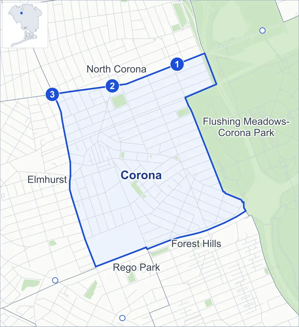
- Corona
- A neighboring area
- Park
- A station in the list
- Another station
Neighborhood areas and streets: NYC Department of City Planning. Parks: NYC Parks. Stations: MTA.
Neighboring areas
- North Corona north
- Flushing Meadows-Corona Park northeast
- Forest Hills southeast
- Rego Park south
- Elmhurst west
Subway stations
- 111 St lines 7
- 103 St-Corona Plaza lines 7
- Junction Blvd lines 7 accessible
Getting around
Three subway stations and buses on 11 routes stop in or at the edge of Corona.
- 3 subway stations
- 1 of them listed by the MTA as fully accessible
- 6 local bus routes
- 5 express bus routes
Local bus routes
- Q14
- Q23
- Q58
- Q72
- Q88
- Q98
Express bus routes
- QM10
- QM11
- QM12
- QM40
- QM42
Safety record
Between 2021 and 2025, its corners averaged more police-reported crashes than the average Queens corner.
- 1,879 police-reported crashes at its corners
- 8.5 a corner, on average
- 5.2 the average Queens corner
- 17 corners with a clean record
Signal or safety changes on City record, at 48 of its corners
- Leading pedestrian intervals
- 41
- Accessible pedestrian signals
- 21
- Turn calming
- 6
- Barnes Dance all-way crossings
- 3
- Safety Improvement Projects
- 2
- Enhanced crossings
- 1
Camera tickets
In 2025 its corners had more red-light camera tickets than school-zone speed or bus-lane tickets.
- 5,355 red-light camera tickets at one corner
- 4,790 school-zone speed camera tickets at six corners
- 0 bus-lane camera tickets
- Most red-light tickets
- Horace Harding Expressway & 108th Street, 5,355
- Most speed tickets
- Van Cleef Street & Saultell Avenue, 1,716
People and homes
The 2020 Census counted 73,822 residents in Corona, about 85,800 per square mile.
- 22,216 homes, 2020 Census
- 1,071 homes added since April 2010, net, by City Planning's count
Half of its 4,359 residential lots hold buildings from 1931 or earlier, and 54% of them date from before 1940, by the City's tax lot records.
Parks and landmarks
- Parkland
- 7.6 acres of NYC Parks property
- The largest pieces
- Park Of The Americas (3 acres), Corona Golf Playground (1.7 acres) and Simeone Park (1.6 acres)
- Designated landmarks
- The Fire Engine Company 289, Ladder Company 138; and the Congregation Tifereth Israel
Streets and trees
- Trees
- 3,033 in NYC Parks' records, most often London planetree, Callery pear and thornless honeylocust
- Street with the most corners
- Corona Avenue, with 23 of the area's 220
- Height above sea level
- From 13 feet at 101st Street & Lewis Avenue to 63 feet at 97th Street & 40th Road
- Honorary street names
- 13 at its corners, enacted by local law
Schools and libraries
The City lists 11 schools and one library in Corona.
- Public schools
- 9
- Charter and private schools
- 2
- Library
- Lefrak City Library
Bike share
By the station list of October 3, 2026, 24 bike-share stations stand in Corona.
- 24 bike-share stations
Public safety
How complaints are countedIn 2025 the NYPD recorded 548 major felonies at places in Corona.
Recorded by the NYPD at places in Corona
- 780 major felonies in 2024 232 fewer in 2025
- 1,706 other felonies, misdemeanors and violations in 2025
In 2025, on the streets along the edge of Corona, the NYPD recorded another 216 major felonies. Counting the streets along its edge, in 2025 the NYPD recorded 10.3 major felonies for every thousand residents the 2020 Census counted in Corona.
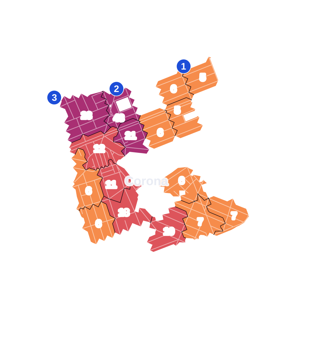
- 5 to 9
- 10 to 19
- 20 to 49
- 50 to 99
- 100 or more
- Not shaded: fewer than 5, held back under the rules in How complaints are counted, parks and public-housing grounds, and land in no patch
- Police precinct
- 110th
From January to June 2026 the NYPD recorded 329 major felonies at places in Corona, against 270 in the same months of 2025.
Sources: the NYPD's Complaint Data Historic, updated April 28, 2026, and Complaint Data Current (Year To Date), updated July 27, 2026, on NYC Open Data. Figures to June 30, 2026.
Street corners
- 41st Avenue & 97th Place
- 41st Avenue & 97th Street
- 41st Avenue & 98th Street
- 41st Avenue & 99th Street
- 41st Avenue & 100th Street
- 41st Avenue & 102nd Street
- 41st Avenue & 103rd Street
- 41st Avenue & 104th Street
- 41st Avenue & 108th Street
- 41st Avenue & 111th Street
- 41st Avenue & 114th Street
- 41st Avenue & National Street
- 42nd Avenue & 97th Place
- 42nd Avenue & 103rd Street
- 42nd Avenue & National Street
- 43rd Avenue & 97th Place
- 43rd Avenue & 99th Street
- 43rd Avenue & 102nd Street
- 43rd Avenue & 104th Street
- 43rd Avenue & 108th Street
- 43rd Avenue & 111th Street
- 43rd Avenue & 114th Street
- 43rd Avenue & National Street
- 44th Avenue & 97th Place
- 44th Avenue & National Street
- 45th Avenue & 97th Place
- 45th Avenue & 104th Street
- 45th Avenue & 108th Street
- 45th Avenue & 111th Street
- 45th Avenue & Junction Boulevard
- 45th Avenue & National Street
- 45th Avenue & Nicolls Avenue
- 46th Avenue & 104th Street
- 46th Avenue & 109th Street
- 46th Avenue & 111th Street
- 46th Avenue & Corona Avenue
- 46th Avenue & Nicolls Avenue
- 47th Avenue & 102nd Street
- 47th Avenue & 104th Street
- 47th Avenue & 108th Street
- 47th Avenue & 109th Street
- 47th Avenue & 111th Street
- 48th Avenue & 104th Street
- 48th Avenue & 111th Street
- 49th Avenue & 106th Street
- 50th Avenue & 96th Street
- 50th Avenue & 97th Place
- 50th Avenue & 101st Street
- 50th Avenue & 111th Street
- 50th Avenue & Corona Avenue
- 50th Avenue & Junction Boulevard
- 51st Avenue & 96th Street
- 51st Avenue & 103rd Street
- 51st Avenue & 111th Street
- 51st Avenue & Alstyne Avenue
- 51st Avenue & Corona Avenue
- 51st Avenue & Junction Boulevard
- 52nd Avenue & Junction Boulevard
- 53rd Avenue & 103rd Street
- 53rd Avenue & 106th Street
- 53rd Avenue & 108th Street
- 53rd Avenue & 111th Street
- 53rd Avenue & Corona Avenue
- 54th Avenue & Corona Avenue
- 54th Avenue & Otis Avenue
- 55th Avenue & 97th Place
- 55th Avenue & Corona Avenue
- 56th Avenue & 111th Street
- 56th Avenue & Corona Avenue
- 56th Avenue & Junction Boulevard
- 57th Avenue & 97th Place
- 57th Avenue & 98th Place
- 57th Avenue & 100th Street
- 57th Avenue & Martense Avenue
- 58th Avenue & 99th Street
- 58th Avenue & Calloway Street
- 58th Avenue & Junction Boulevard
- 59th Avenue & Calloway Street
- 60th Avenue & Junction Boulevard
- 60th Avenue & Otis Avenue
- 96th Street & 55th Avenue
- 96th Street & 57th Avenue
- 96th Street & Christie Avenue
- 97th Place & Christie Avenue
- 97th Street & 40th Road
- 97th Street & 45th Avenue
- 97th Street & 50th Avenue
- 97th Street & 51st Avenue
- 97th Street & 55th Avenue
- 97th Street & 57th Avenue
- 97th Street & Christie Avenue
- 97th Street & Corona Avenue
- 98th Street & 40th Road
- 98th Street & 45th Avenue
- 98th Street & 50th Avenue
- 98th Street & 55th Avenue
- 98th Street & 57th Avenue
- 98th Street & Alstyne Avenue
- 98th Street & Christie Avenue
- 98th Street & Corona Avenue
- 99th Street & 42nd Avenue
- 99th Street & 50th Avenue
- 99th Street & 55th Avenue
- 99th Street & 57th Avenue
- 99th Street & 59th Avenue
- 99th Street & 60th Avenue
- 99th Street & 101st Street
- 99th Street & Alstyne Avenue
- 99th Street & Christie Avenue
- 99th Street & Corona Avenue
- 100th Street & 40th Road
- 100th Street & Lewis Avenue
- 100th Street & Spruce Avenue
- 101st Street & Christie Avenue
- 101st Street & Lewis Avenue
- 101st Street & Martense Avenue
- 101st Street & Radcliff Avenue
- 102nd Street & 40th Road
- 102nd Street & 42nd Avenue
- 102nd Street & 44th Avenue
- 102nd Street & 45th Avenue
- 102nd Street & 46th Avenue
- 102nd Street & Alstyne Avenue
- 102nd Street & Christie Avenue
- 102nd Street & Corona Avenue
- 102nd Street & Larue Avenue
- 102nd Street & Lewis Avenue
- 102nd Street & Martense Avenue
- 102nd Street & National Street
- 102nd Street & Nicolls Avenue
- 102nd Street & Radcliff Avenue
- 102nd Street & Spruce Avenue
- 102nd Street & Strong Avenue
- 103rd Street & 52nd Avenue
- 103rd Street & Alstyne Avenue
- 103rd Street & Christie Avenue
- 103rd Street & Corona Avenue
- 103rd Street & Larue Avenue
- 103rd Street & Lewis Avenue
- 103rd Street & Martense Avenue
- 103rd Street & Radcliff Avenue
- 103rd Street & Strong Avenue
- 104th Street & 42nd Avenue
- 104th Street & 44th Avenue
- 104th Street & 49th Avenue
- 104th Street & Alstyne Avenue
- 104th Street & Corona Avenue
- 104th Street & Martense Avenue
- 104th Street & Nicolls Avenue
- 105th Street & Martense Avenue
- 106th Street & Martense Avenue
- 108th Street & 42nd Avenue
- 108th Street & 44th Avenue
- 108th Street & 46th Avenue
- 108th Street & 48th Avenue
- 108th Street & 49th Avenue
- 108th Street & 50th Avenue
- 108th Street & 51st Avenue
- 108th Street & 52nd Avenue
- 108th Street & Martense Avenue
- 108th Street & Otis Avenue
- 108th Street & Penrod Street
- 108th Street & Van Doren Street
- 108th Street & Waldron Street
- 108th Street & Westside Avenue
- 111th Street & 42nd Avenue
- 111th Street & 44th Avenue
- 111th Street & 49th Avenue
- 111th Street & 52nd Avenue
- 111th Street & 54th Avenue
- 111th Street & 55th Avenue
- 111th Street & Carousel Loop
- 111th Street & Corona Avenue
- 114th Street & 42nd Avenue
- Alstyne Avenue & 98th Place
- Corona Avenue & 97th Place
- Corona Avenue & 106th Street
- Corona Avenue & Alstyne Avenue
- Corona Avenue & Martense Avenue
- Corona Avenue & National Street
- Corona Avenue & Otis Avenue
- Corona Avenue & Saultell Avenue
- Corona Avenue & Westside Avenue
- Grand Central Parkway & Roosevelt Avenue
- Granger Street & Westside Avenue
- Horace Harding Expressway & 99th Street
- Horace Harding Expressway & 108th Street
- Horace Harding Expressway & Calloway Street
- Horace Harding Expressway & Granger Street
- Horace Harding Expressway & Long Island Expressway
- Horace Harding Expressway & Long Island Expressway (Exit 20)
- Horace Harding Expressway & Otis Avenue
- Horace Harding Expressway & Penrod Street
- Horace Harding Expressway & Saultell Avenue
- Horace Harding Expressway & Van Cleef Street
- Horace Harding Expressway & Van Doren Street
- Horace Harding Expressway & Waldron Street
- Horace Harding Expressway & Westside Avenue
- Horace Harding Expressway & Xenia Street
- Junction Boulevard & Christie Avenue
- Martense Avenue & Granger Street
- Martense Avenue & Penrod Street
- Otis Avenue & Granger Street
- Otis Avenue & Penrod Street
- Otis Avenue & Van Doren Street
- Otis Avenue & Xenia Street
- Roosevelt Avenue & 98th Street
- Roosevelt Avenue & 104th Street
- Roosevelt Avenue & 111th Street
- Roosevelt Avenue & 112th Street
- Roosevelt Avenue & 114th Street
- Van Cleef Street & Saultell Avenue
- Van Cleef Street & Westside Avenue
- Van Doren Street & Martense Avenue
- Van Doren Street & Saultell Avenue
- Van Doren Street & Westside Avenue
- Waldron Street & Martense Avenue
- Waldron Street & Otis Avenue
- Waldron Street & Saultell Avenue
- Xenia Street & Westside Avenue
How the figures above are measured: Methodology.