Rego Park
Neighborhood · Queens
Rego Park lies between Woodhaven Boulevard and Forest Hills, reaching from the Long Island Expressway across Queens Boulevard toward Forest Park.
- 0.72 square miles
- 30,741 residents, 2020 Census
- 121 street corners
- 2 subway stations
- 20 bus routes
English and Dutch farmers had settled the area as Whitepot by 1653, and in the 1920s the Real Good Construction Company bought the land, built more than 500 Tudor-style houses and named the development by joining the first two letters of Real and Good. Stores went up on Queens Boulevard in 1926 and apartment buildings followed in 1927-28, and Lost Battalion Hall was built in 1939 as a meeting hall for veterans' groups.
Sources: Rego Park (Wikipedia); Rego Park, Queens (Forgotten New York).
Rego Park borders six areas, and Alderton Street holds more of its corners than any other street, 26 of 121.
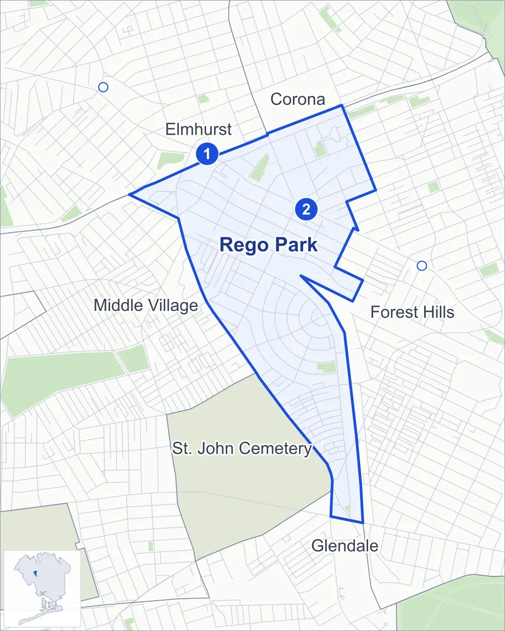
- Rego Park
- A neighboring area
- Park
- A station in the list
- Another station
Neighborhood areas and streets: NYC Department of City Planning. Parks: NYC Parks. Stations: MTA.
Neighboring areas
- Corona north
- Forest Hills southeast
- St. John Cemetery south
- Glendale south
- Middle Village west
- Elmhurst northwest
Subway stations
- Woodhaven Blvd lines M R
- 63 Dr-Rego Park lines M R
Getting around
Two subway stations and buses on 20 routes stop in or at the edge of Rego Park.
- 2 subway stations
- 12 local bus routes
- 8 express bus routes
Local bus routes
- Q11
- Q14
- Q23
- Q29
- Q38
- Q52-SBS
- Q53-SBS
- Q54
- Q59
- Q60
- Q72
- Q88
Express bus routes
- BM5
- QM10
- QM11
- QM12
- QM15
- QM18
- QM40
- QM42
Safety record
Between 2021 and 2025, its corners averaged more police-reported crashes than the average Queens corner.
- 971 police-reported crashes at its corners
- 8.0 a corner, on average
- 5.2 the average Queens corner
- 20 corners with a clean record
Signal or safety changes on City record, at 23 of its corners
- Leading pedestrian intervals
- 16
- Accessible pedestrian signals
- 11
- Turn calming
- 6
- Barnes Dance all-way crossings
- 2
- Safety Improvement Projects
- 1
Camera tickets
In 2025 its corners had more bus-lane camera tickets than school-zone speed or red-light tickets.
- 8,382 red-light camera tickets at three corners
- 8,709 school-zone speed camera tickets at four corners
- 76,688 bus-lane camera tickets at two corners
- Most red-light tickets
- Woodhaven Boulevard & Yellowstone Boulevard, 4,216
- Most speed tickets
- Queens Boulevard & 63rd Drive, 3,110
- Most bus-lane tickets
- Woodhaven Boulevard & Wetherole Street, 76,045
People and homes
The 2020 Census counted 30,741 residents in Rego Park, about 42,700 per square mile.
- 13,767 homes, 2020 Census
- 1,441 homes added since April 2010, net, by City Planning's count
Half of its 2,416 residential lots hold buildings from 1937 or earlier, and 59% of them date from before 1940, by the City's tax lot records.
Parks
- Parkland
- 5.5 acres of NYC Parks property
- The largest pieces
- Lost Battalion Hall Recreation Center (2.4 acres), the Painter's Playground (1.7 acres) and Horace Harding Playground (1.3 acres)
Streets and trees
- Trees
- 2,467 in NYC Parks' records, most often thornless honeylocust, London planetree and pin oak
- Street with the most corners
- Alderton Street, with 26 of the area's 121
- Height above sea level
- From 15 feet at Junction Boulevard & 62nd Drive to 96 feet at 64th Road & Asquith Crescent
- Honorary street name
- 1 at its corners, enacted by local law
Schools and libraries
The City lists seven schools and one library in Rego Park.
- Public schools
- 4
- Charter and private schools
- 3
- Library
- Rego Park Library
Bike share
By the station list of October 3, 2026, eight bike-share stations stand in Rego Park.
- 8 bike-share stations
Public safety
How complaints are countedIn 2025 the NYPD recorded 263 major felonies at places in Rego Park.
Recorded by the NYPD at places in Rego Park
- 200 major felonies in 2024
- 855 other felonies, misdemeanors and violations in 2025
In 2025, on the streets along the edge of Rego Park, the NYPD recorded another 77 major felonies. Counting the streets along its edge, in 2025 the NYPD recorded 11.1 major felonies for every thousand residents the 2020 Census counted in Rego Park.
- Police precinct
- 112th
From January to June 2026 the NYPD recorded 142 major felonies at places in Rego Park, against 133 in the same months of 2025.
Sources: the NYPD's Complaint Data Historic, updated April 28, 2026, and Complaint Data Current (Year To Date), updated July 27, 2026, on NYC Open Data. Figures to June 30, 2026.
Street corners
- 60th Avenue & 60th Road
- 60th Road & Van Horn Street
- 62nd Avenue & 93rd Street
- 62nd Avenue & Alderton Street
- 62nd Avenue & Booth Street
- 62nd Avenue & Saunders Street
- 62nd Avenue & Wetherole Street
- 62nd Drive & 97th Place
- 62nd Drive & Alderton Street
- 63rd Avenue & Alderton Street
- 63rd Avenue & Booth Street
- 63rd Avenue & Bourton Street
- 63rd Avenue & Carlton Street
- 63rd Avenue & Fitchett Street
- 63rd Avenue & Haring Street
- 63rd Avenue & Saunders Street
- 63rd Avenue & Wetherole Street
- 63rd Drive & 98th Place
- 63rd Drive & Alderton Street
- 63rd Drive & Booth Street
- 63rd Drive & Bourton Street
- 63rd Drive & Carlton Street
- 63rd Drive & Fitchett Street
- 63rd Drive & Haring Street
- 63rd Drive & Penelope Avenue
- 63rd Drive & Saunders Street
- 63rd Drive & Wetherole Street
- 63rd Road & 98th Place
- 64th Road & Alderton Street
- 64th Road & Asquith Crescent
- 64th Road & Boelsen Crescent
- 64th Road & Booth Street
- 64th Road & Cromwell Crescent
- 64th Road & Dieterle Crescent
- 64th Road & Ellwell Crescent
- 64th Road & Fitchett Street
- 64th Road & Saunders Street
- 64th Road & Wetherole Street
- 65th Avenue & Fitchett Street
- 65th Drive & Boelsen Crescent
- 65th Drive & Cromwell Crescent
- 65th Road & Fitchett Street
- 66th Avenue & Alderton Street
- 66th Avenue & Fitchett Street
- 66th Road & Fitchett Street
- 67th Avenue & Alderton Street
- 67th Avenue & Fitchett Street
- 67th Road & Fitchett Street
- 68th Avenue & Alderton Street
- 97th Street & 62nd Drive
- 97th Street & 63rd Drive
- 97th Street & 63rd Road
- 98th Street & 62nd Drive
- 98th Street & 63rd Drive
- 98th Street & 63rd Road
- 98th Street & 64th Avenue
- 98th Street & 65th Avenue
- 99th Street & 62nd Drive
- 99th Street & 63rd Drive
- 99th Street & 63rd Road
- Alderton Street & 62nd Road
- Alderton Street & 66th Road
- Alderton Street & 67th Drive
- Alderton Street & 67th Road
- Alderton Street & Asquith Crescent (north-west)
- Alderton Street & Asquith Crescent (south-east)
- Alderton Street & Boelsen Crescent (north-west)
- Alderton Street & Boelsen Crescent (south-east)
- Alderton Street & Cromwell Crescent (north-west)
- Alderton Street & Cromwell Crescent (south-east)
- Alderton Street & Dartmouth Street
- Alderton Street & Dieterle Crescent (north-west)
- Alderton Street & Dieterle Crescent (south-east)
- Alderton Street & Ellwell Crescent (north-west)
- Alderton Street & Ellwell Crescent (south-east)
- Alderton Street & Trotting Course Lane
- Austin Street & 62nd Avenue
- Austin Street & 63rd Avenue
- Austin Street & 63rd Drive
- Austin Street & 64th Road
- Austin Street & 65th Road
- Austin Street & Eliot Avenue
- Carlton Street & Boelsen Crescent
- Cromwell Crescent & Carlton Street
- Dieterle Crescent & 65th Drive
- Dieterle Crescent & Carlton Street
- Eliot Avenue & Booth Street
- Eliot Avenue & Saunders Street
- Eliot Avenue & Wetherole Street
- Ellwell Crescent & 65th Drive
- Ellwell Crescent & Carlton Street
- Fitchett Street & 65th Drive
- Horace Harding Expressway & 93rd Street
- Horace Harding Expressway & 97th Place
- Horace Harding Expressway & 97th Street
- Horace Harding Expressway & 98th Street
- Horace Harding Expressway & Long Island Expressway
- Horace Harding Expressway & Queens Boulevard
- Junction Boulevard & 62nd Drive
- Long Island Expressway & Junction Boulevard
- Long Island Expressway & Queens Boulevard
- Long Island Expressway & Woodhaven Boulevard
- Queens Boulevard & 63rd Avenue
- Queens Boulevard & 63rd Drive
- Queens Boulevard & 65th Avenue
- Trotting Course Lane & Polo Place
- Woodhaven Boulevard & 60th Avenue
- Woodhaven Boulevard & 62nd Road
- Woodhaven Boulevard & 64th Road
- Woodhaven Boulevard & 66th Avenue
- Woodhaven Boulevard & 67th Road
- Woodhaven Boulevard & Dry Harbor Road
- Woodhaven Boulevard & Eliot Avenue
- Woodhaven Boulevard & Furmanville Avenue
- Woodhaven Boulevard & Penelope Avenue
- Woodhaven Boulevard & Trotting Course Lane
- Woodhaven Boulevard & Wetherole Street
- Woodhaven Boulevard & Yellowstone Boulevard
- Yellowstone Boulevard & Alderton Street
- Yellowstone Boulevard & Alderton Street at 68th Road
- Yellowstone Boulevard & Kessel Street
How the figures above are measured: Methodology.