Glendale
Neighborhood · Queens
Between Ridgewood and Forest Park in west-central Queens, Glendale stretches along Myrtle Avenue, its main street.
- 1.08 square miles
- 35,135 residents, 2020 Census
- 232 street corners
- 17 bus routes
Once a swampy part of the town of Newtown known as Fresh Pond, it took its name from Glendale, Ohio, in the 1860s and grew into a German farming community. In the 1890s picnic parks such as Glendale Schuetzen Park opened along Myrtle Avenue, and today the neighborhood is largely ringed by cemeteries, among them Union Field and Mount Carmel, a Jewish cemetery of more than 100 acres.
Sources: Glendale, Queens (Wikipedia); Mount Carmel Cemetery (Mount Carmel Cemetery Association).
Glendale borders eight areas, and Myrtle Avenue holds more of its corners than any other street, 47 of 232.
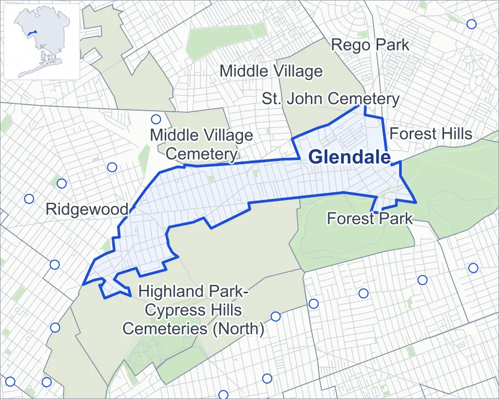
- Glendale
- A neighboring area
- Park
- Another station
Neighborhood areas and streets: NYC Department of City Planning. Parks: NYC Parks. Stations: MTA.
Neighboring areas
- Middle Village north
- St. John Cemetery northeast
- Rego Park northeast
- Forest Park east
- Forest Hills east
- Highland Park-Cypress Hills Cemeteries (North) southwest
- Ridgewood west
- Middle Village Cemetery northwest
Getting around
Buses on 17 routes stop in or at the edge of Glendale.
- 10 local bus routes
- 7 express bus routes
Local bus routes
- B13
- Q11
- Q23
- Q29
- Q39
- Q47
- Q52-SBS
- Q53-SBS
- Q54
- Q55
Express bus routes
- BM5
- QM12
- QM15
- QM24
- QM25
- QM34
- QM42
Safety record
Between 2021 and 2025, its corners averaged more police-reported crashes than the average Queens corner.
- 1,296 police-reported crashes at its corners
- 5.6 a corner, on average
- 5.2 the average Queens corner
- 24 corners with a clean record
Signal or safety changes on City record, at 24 of its corners
- Leading pedestrian intervals
- 15
- Accessible pedestrian signals
- 9
- Barnes Dance all-way crossings
- 2
- Safety Improvement Projects
- 2
- Turn calming
- 1
- Enhanced crossings
- 1
Camera tickets
In 2025 its corners had more school-zone speed camera tickets than bus-lane or red-light tickets.
- 1,866 red-light camera tickets at one corner
- 17,040 school-zone speed camera tickets at nine corners
- 4,293 bus-lane camera tickets at two corners
- Most red-light tickets
- Union Turnpike & Woodhaven Boulevard, 1,866
- Most speed tickets
- Union Turnpike & Woodhaven Boulevard, 11,445
- Most bus-lane tickets
- Metropolitan Avenue & Woodhaven Boulevard, 2,410
People and homes
The 2020 Census counted 35,135 residents in Glendale, about 32,500 per square mile.
- 13,556 homes, 2020 Census
- 98 homes added since April 2010, net, by City Planning's count
Half of its 6,378 residential lots hold buildings from 1925 or earlier, and 86% of them date from before 1940, by the City's tax lot records.
Parks
- Parkland
- 3.8 acres of NYC Parks property
- The largest pieces
- Forest Park (1.5 acres), "Uncle" Vito F. Maranzano Glendale Playground (1.2 acres) and Pinocchio Playground (1 acre)
Streets and trees
- Trees
- 3,934 in NYC Parks' records, most often London planetree, thornless honeylocust and littleleaf linden
- Street with the most corners
- Myrtle Avenue, with 47 of the area's 232
- Height above sea level
- From 47 feet at Woodhaven Boulevard & Cooper Avenue to 131 feet at Myrtle Avenue & Woodhaven Boulevard
- Honorary street names
- 5 at its corners, enacted by local law
Schools and libraries
The City lists four schools and one library in Glendale.
- Public schools
- 3
- Charter or private school
- 1
- Library
- Glendale Library
Bike share
By the station list of October 3, 2026, four bike-share stations stand in Glendale.
- 4 bike-share stations
Public safety
How complaints are countedIn 2025 the NYPD recorded 269 major felonies at places in Glendale.
Recorded by the NYPD at places in Glendale
- 302 major felonies in 2024
- 809 other felonies, misdemeanors and violations in 2025
In 2025, on the streets along the edge of Glendale, the NYPD recorded another 68 major felonies. Counting the streets along its edge, in 2025 the NYPD recorded 9.6 major felonies for every thousand residents the 2020 Census counted in Glendale.
- Police precincts
- 104th (most of the area), 112th
From January to June 2026 the NYPD recorded 120 major felonies at places in Glendale, against 121 in the same months of 2025.
Sources: the NYPD's Complaint Data Historic, updated April 28, 2026, and Complaint Data Current (Year To Date), updated July 27, 2026, on NYC Open Data. Figures to June 30, 2026.
Street corners
- 57th Street & Cabot Road
- 57th Street & Clover Place
- 60th Lane & 80th Avenue
- 60th Lane & St Felix Avenue
- 60th Place & St Felix Avenue
- 60th Street & 79th Avenue
- 61st Street & 60th Lane
- 61st Street & 80th Avenue
- 61st Street & Cooper Avenue
- 61st Street & St Felix Avenue
- 62nd Street & 74th Avenue
- 62nd Street & 80th Avenue
- 64th Place & Otto Road
- 64th Street & 80th Avenue
- 64th Street & Central Avenue
- 65th Place & Cypress Hills Street
- 65th Street & 80th Avenue
- 65th Street & Cypress Hills Street
- 65th Street & Otto Road
- 66th Street & Otto Road
- 67th Street & Otto Road
- 69th Place & Luther Road
- 69th Street & 70th Avenue
- 69th Street & Central Avenue
- 69th Street & Cooper Avenue
- 69th Street & Otto Road
- 70th Avenue & 65th Place
- 70th Avenue & 66th Place
- 70th Avenue & 66th Street
- 70th Avenue & 67th Place
- 70th Avenue & 67th Street
- 70th Avenue & 68th Place
- 70th Avenue & 68th Street
- 70th Avenue & 69th Place
- 70th Street & 70th Avenue
- 70th Street & Central Avenue
- 70th Street & Cooper Avenue
- 71st Street & Central Avenue
- 71st Street & Cooper Avenue
- 72nd Place & Edsall Avenue
- 72nd Street & Central Avenue
- 72nd Street & Edsall Avenue
- 72nd Street & Indiana Avenue
- 73rd Avenue & Woodhaven Boulevard
- 73rd Place & Edsall Avenue
- 73rd Street & Edsall Avenue
- 74th Avenue & 64th Lane
- 74th Avenue & 64th Place
- 74th Avenue & Cypress Hills Street
- 74th Street & 78th Avenue
- 74th Street & Bike Path
- 74th Street & Cooper Avenue
- 75th Avenue & 60th Lane
- 75th Avenue & 60th Place
- 75th Avenue & 61st Street
- 75th Avenue & 62nd Street
- 75th Avenue & 64th Street
- 75th Street & 78th Avenue
- 75th Street & Edsall Avenue
- 76th Street & 77th Avenue
- 76th Street & 78th Avenue
- 76th Street & Edsall Avenue
- 77th Avenue & 79th Place
- 77th Road & 79th Place
- 78th Avenue & 60th Lane
- 78th Avenue & 60th Street
- 78th Avenue & 62nd Street
- 78th Avenue & 64th Lane
- 78th Avenue & 64th Place
- 78th Avenue & 64th Street
- 78th Avenue & 65th Street
- 78th Avenue & 73rd Place
- 78th Avenue & 79th Place
- 78th Avenue & Cypress Avenue
- 78th Avenue & Cypress Hills Street
- 78th Road & 79th Lane
- 78th Street & 77th Avenue
- 78th Street & 78th Avenue
- 78th Street & Myrtle Avenue
- 79th Avenue & St Felix Avenue
- 79th Street & 77th Avenue
- 79th Street & 78th Avenue
- 79th Street & Myrtle Avenue
- 80th Avenue & 64th Lane
- 80th Avenue & 64th Place
- 80th Street & 77th Road
- 80th Street & 78th Avenue
- 80th Street & 78th Road
- 80th Street & Myrtle Avenue
- 81st Road & Margaret Place
- 81st Street & 77th Avenue
- 81st Street & 78th Avenue
- 81st Street & 78th Road
- 81st Street & 82nd Street
- 81st Street & Cooper Avenue
- 82nd Avenue & Trotting Course Lane
- 82nd Street & 77th Avenue
- 82nd Street & 78th Avenue
- 82nd Street & 78th Road
- 82nd Street & Cooper Avenue
- 83rd Street & 77th Avenue
- 83rd Street & 78th Avenue
- 83rd Street & 78th Road
- 83rd Street & Cooper Avenue
- 84th Street & 77th Avenue
- 84th Street & 78th Avenue
- 84th Street & Cooper Avenue
- 84th Street & Doran Avenue
- 84th Street & Myrtle Avenue
- 85th Street & 77th Avenue
- 85th Street & 78th Avenue
- 86th Street & 77th Avenue
- 86th Street & 78th Avenue
- 87th Street & 77th Avenue
- 87th Street & 78th Avenue
- 87th Street & 79th Avenue
- 88th Street & 72nd Drive
- 88th Street & 74th Avenue
- 88th Street & 75th Avenue
- 88th Street & 76th Avenue
- 88th Street & 77th Avenue
- 88th Street & 78th Avenue
- 88th Street & 79th Avenue
- 88th Street & 81st Avenue
- 88th Street & 81st Road
- 88th Street & Aubrey Avenue
- 88th Street & Cooper Avenue
- 88th Street & Doran Avenue
- 88th Street & Myrtle Avenue
- 88th Street & Rutledge Avenue
- 89th Street & 74th Avenue
- 89th Street & Doran Avenue
- 89th Street & Rutledge Avenue
- Central Avenue & 64th Place
- Central Avenue & 65th Place
- Central Avenue & 65th Street
- Central Avenue & 66th Place
- Central Avenue & 66th Street
- Central Avenue & 67th Place
- Central Avenue & 67th Street
- Central Avenue & 68th Place
- Central Avenue & 68th Street
- Central Avenue & 69th Place
- Central Avenue & 71st Place
- Central Avenue & 72nd Place
- Central Avenue & 73rd Street
- Cooper Avenue & 59th Street
- Cooper Avenue & 60th Lane
- Cooper Avenue & 60th Street
- Cooper Avenue & 62nd Street
- Cooper Avenue & 64th Lane
- Cooper Avenue & 64th Place
- Cooper Avenue & 64th Street
- Cooper Avenue & 65th Place
- Cooper Avenue & 65th Street
- Cooper Avenue & 66th Place
- Cooper Avenue & 66th Street
- Cooper Avenue & 67th Place
- Cooper Avenue & 67th Street
- Cooper Avenue & 68th Street
- Cooper Avenue & 69th Place
- Cooper Avenue & 71st Place
- Cooper Avenue & 72nd Place
- Cooper Avenue & 72nd Street
- Cooper Avenue & 73rd Place
- Cooper Avenue & 73rd Street
- Cooper Avenue & 80th Avenue
- Cooper Avenue & Central Avenue
- Cooper Avenue & Cypress Avenue
- Cooper Avenue & Cypress Hills Street
- Cooper Avenue & St Felix Avenue
- Cypress Avenue & 79th Avenue
- Cypress Avenue & Cabot Road
- Cypress Avenue & Clover Place
- Cypress Hills Street & 64th Place
- Edsall Avenue & 71st Place
- Jackie Robinson Parkway & Woodhaven Boulevard
- Metropolitan Avenue & Aubrey Avenue
- Metropolitan Avenue & Cooper Avenue
- Metropolitan Avenue & Trotting Course Lane
- Metropolitan Avenue & Woodhaven Boulevard
- Myrtle Avenue & 62nd Street
- Myrtle Avenue & 64th Place
- Myrtle Avenue & 64th Street
- Myrtle Avenue & 65th Place
- Myrtle Avenue & 65th Street
- Myrtle Avenue & 66th Place
- Myrtle Avenue & 66th Street
- Myrtle Avenue & 67th Place
- Myrtle Avenue & 67th Street
- Myrtle Avenue & 68th Place
- Myrtle Avenue & 68th Street
- Myrtle Avenue & 69th Place
- Myrtle Avenue & 69th Street
- Myrtle Avenue & 70th Street
- Myrtle Avenue & 71st Place
- Myrtle Avenue & 71st Street
- Myrtle Avenue & 72nd Place
- Myrtle Avenue & 72nd Street
- Myrtle Avenue & 73rd Place
- Myrtle Avenue & 73rd Street
- Myrtle Avenue & 74th Street
- Myrtle Avenue & 75th Street
- Myrtle Avenue & 76th Street
- Myrtle Avenue & 79th Lane
- Myrtle Avenue & 79th Place
- Myrtle Avenue & 81st Avenue
- Myrtle Avenue & 81st Road
- Myrtle Avenue & 81st Street
- Myrtle Avenue & 82nd Avenue
- Myrtle Avenue & 82nd Street
- Myrtle Avenue & 83rd Street
- Myrtle Avenue & 85th Street
- Myrtle Avenue & 88th Lane
- Myrtle Avenue & 88th Place
- Myrtle Avenue & 89th Street
- Myrtle Avenue & Central Avenue
- Myrtle Avenue & Cooper Avenue
- Myrtle Avenue & Cypress Hills Street
- Myrtle Avenue & J Robinson Parkway
- Myrtle Avenue & Woodhaven Boulevard
- Otto Road & 67th Place
- Otto Road & 68th Place
- Pedestrian Overpass & Woodhaven Boulevard Footbridge
- Trotting Course Lane & Margaret Place
- Union Turnpike & 87th Street
- Union Turnpike & 88th Street
- Union Turnpike & Myrtle Avenue
- Union Turnpike & Myrtle Avenue at Forest Park Drive
- Union Turnpike & Woodhaven Boulevard
- Woodhaven Boulevard & 81st Road
- Woodhaven Boulevard & Cooper Avenue
How the figures above are measured: Methodology.