Ridgewood
Neighborhood · Queens
Ridgewood sits on the Queens side of the Brooklyn border next to Bushwick, with Maspeth to the north and Glendale to the southeast.
- 1.53 square miles
- 66,402 residents, 2020 Census
- 288 street corners
- 6 subway stations
- 22 bus routes
Its land once straddled the colonial towns of Newtown and Bushwick, and the neighborhood is named for the nearby Ridgewood Reservoir, built in the late 1850s. German immigrants drove much of its growth, and most houses in its historic core went up between 1906 and World War I, many designed by one local architectural firm and built of Staten Island brick; about 990 buildings form the Central Ridgewood Historic District, designated in 2014.
Sources: Central Ridgewood Historic District Designation Report (NYC Landmarks Preservation Commission); Ridgewood, Queens (Wikipedia).
Ridgewood borders eight areas, and Seneca Avenue holds more of its corners than any other street, 29 of 302.
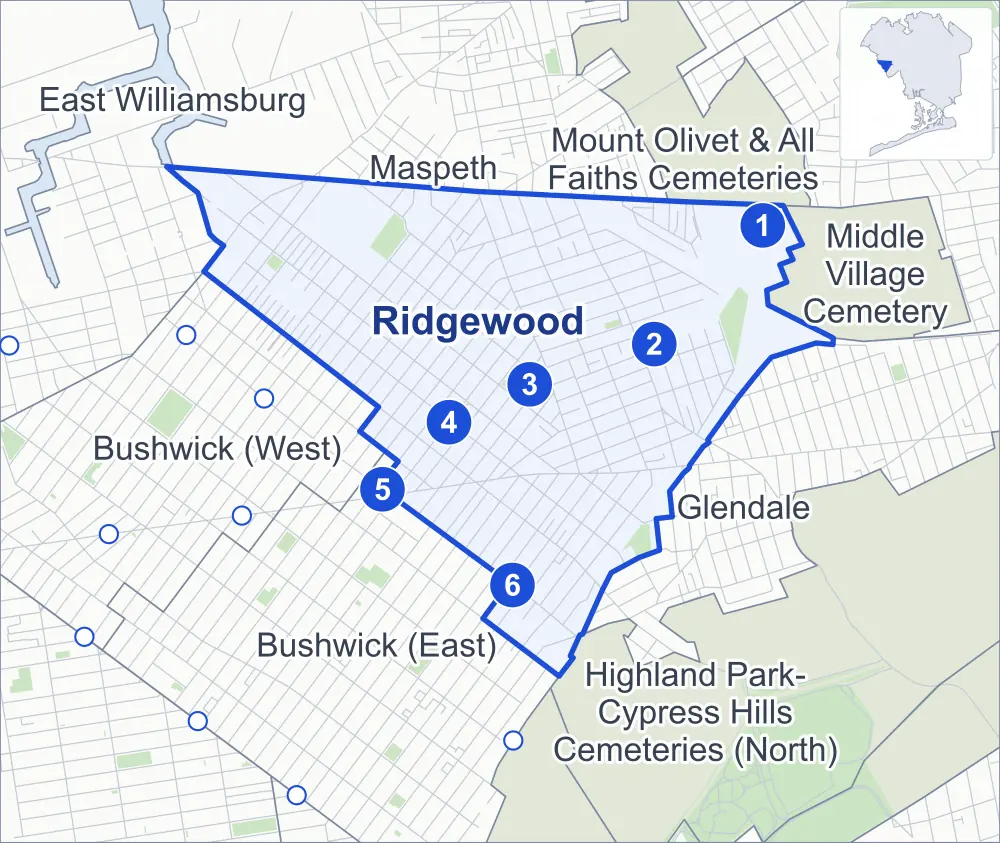
- Ridgewood
- A neighboring area
- Park
- A station in the list
- Another station
Neighborhood areas and streets: NYC Department of City Planning. Parks: NYC Parks. Stations: MTA.
Neighboring areas
- Mount Olivet & All Faiths Cemeteries northeast
- Middle Village Cemetery east
- Glendale southeast
- Bushwick (East) south
- Highland Park-Cypress Hills Cemeteries (North) south
- Bushwick (West) west
- Maspeth northwest
- East Williamsburg northwest
Subway stations
- Middle Village-Metropolitan Av lines M accessible
- Fresh Pond Rd lines M
- Forest Av lines M
- Seneca Av lines M
- Myrtle-Wyckoff Avs lines L accessible
- Halsey St lines L
Getting around
Six subway stations and buses on 22 routes stop in or at the edge of Ridgewood.
- 6 subway stations
- 2 of them listed by the MTA as fully accessible
- 19 local bus routes
- 3 express bus routes
Local bus routes
- B13
- B20
- B26
- B38
- B52
- B54
- B57
- B111
- L90
- M90
- Q14
- Q38
- Q39
- Q54
- Q55
- Q58
- Q67
- Q98
- T410
Express bus routes
- QM24
- QM25
- QM34
Safety record
Between 2021 and 2025, its corners averaged more police-reported crashes than the average Queens corner.
- 2,124 police-reported crashes at its corners
- 7.0 a corner, on average
- 5.2 the average Queens corner
- 18 corners with a clean record
Signal or safety changes on City record, at 77 of its corners
- Leading pedestrian intervals
- 61
- Accessible pedestrian signals
- 56
- Turn calming
- 7
- Safety Improvement Projects
- 5
- Barnes Dance all-way crossings
- 4
Camera tickets
In 2025 its corners had more school-zone speed camera tickets than bus-lane or red-light tickets.
- 0 red-light camera tickets
- 6,073 school-zone speed camera tickets at ten corners
- 1,523 bus-lane camera tickets at one corner
- Most speed tickets
- Metropolitan Avenue & Rentar Plaza, 3,394
- Most bus-lane tickets
- Fresh Pond Road & Woodbine Street, 1,523
People and homes
The 2020 Census counted 66,402 residents in Ridgewood, about 43,400 per square mile.
- 26,014 homes, 2020 Census
- 1,345 homes added since April 2010, net, by City Planning's count
Half of its 7,403 residential lots hold buildings from 1920 or earlier, and 91% of them date from before 1940, by the City's tax lot records.
Parks and landmarks
- Parkland
- 18.4 acres of NYC Parks property
- The largest pieces
- Mafera Park (6.8 acres), Grover Cleveland Playground (5.1 acres) and Evergreen Park (3 acres)
- Designated landmark
- The Ridgewood Theater
- Historic districts
- Central Ridgewood, Ridgewood North, Ridgewood South and Stockholm Street, wholly or partly within Ridgewood
Streets and trees
- Trees
- 6,131 in NYC Parks' records, most often thornless honeylocust, London planetree and littleleaf linden
- Street with the most corners
- Seneca Avenue, with 29 of the area's 302
- Height above sea level
- From 10 feet at Metropolitan Avenue & Onderdonk Avenue to 127 feet at 60th Place & Menahan Street
- Honorary street names
- 7 at its corners, enacted by local law
Schools and libraries
The City lists 15 schools and one library in Ridgewood.
- Public schools
- 12
- Charter and private schools
- 3
- Library
- Ridgewood Library
Bike share and public art
By the station list of October 3, 2026, 42 bike-share stations stand in Ridgewood. The City's public art inventory lists one work in the area: Ridgewood Memorial (1920).
- 42 bike-share stations
- 1 work of public art
Public safety
How complaints are countedIn 2025 the NYPD recorded 534 major felonies at places in Ridgewood.
Recorded by the NYPD at places in Ridgewood
- 623 major felonies in 2024 89 fewer in 2025
- 1,925 other felonies, misdemeanors and violations in 2025
In 2025, on the streets along the edge of Ridgewood, the NYPD recorded another 140 major felonies. Counting the streets along its edge, in 2025 the NYPD recorded 10.2 major felonies for every thousand residents the 2020 Census counted in Ridgewood.
- Police precinct
- 104th
From January to June 2026 the NYPD recorded 279 major felonies at places in Ridgewood, against 264 in the same months of 2025.
Sources: the NYPD's Complaint Data Historic, updated April 28, 2026, and Complaint Data Current (Year To Date), updated July 27, 2026, on NYC Open Data. Figures to June 30, 2026.
Street corners
- 60th Lane & 68th Road
- 60th Lane & Catalpa Avenue
- 60th Lane & Putnam Avenue
- 60th Place & Bleecker Street
- 60th Place & Gates Avenue
- 60th Place & Grove Street
- 60th Place & Kleupfel Court
- 60th Place & Menahan Street
- 60th Street & 68th Road
- 60th Street & 70th Avenue
- 60th Street & Bleecker Street
- 60th Street & Catalpa Avenue
- 60th Street & Putnam Avenue
- 60th Street & St Felix Avenue
- 61st Street & Bleecker Street
- 61st Street & Grove Street
- 61st Street & Menahan Street
- 62nd Street & Catalpa Avenue
- 62nd Street & Cypress Hills Street
- 64th Place & Shaler Avenue
- 64th Street & 68th Avenue
- 64th Street & Catalpa Avenue
- 64th Street & Gates Avenue
- 64th Street & Linden Street
- 64th Street & Madison Street
- 64th Street & Palmetto Street
- 64th Street & Shaler Avenue
- 64th Street & Woodbine Street
- 65th Place & Admiral Avenue
- 65th Place & Catalpa Avenue
- 65th Street & Admiral Avenue
- 65th Street & Catalpa Avenue
- 65th Street & Shaler Avenue
- 67th Avenue & 60th Lane
- 67th Avenue & 60th Place
- 67th Avenue & 60th Street
- 67th Avenue & Forest Avenue
- 67th Avenue & Fresh Pond Road
- 68th Avenue & 60th Lane
- 68th Avenue & 60th Street
- 68th Avenue & 62nd Street
- 68th Avenue & 64th Place
- 68th Avenue & 65th Place
- 68th Avenue & 65th Street
- 68th Avenue & Forest Avenue
- 68th Avenue & Fresh Pond Road
- 68th Road & Forest Avenue
- 68th Road & Woodward Avenue
- 68th Street & Otto Road
- 69th Avenue & 60th Lane
- 69th Avenue & 60th Street
- 69th Avenue & Cypress Hills Street
- 69th Avenue & Forest Avenue
- 69th Avenue & Fresh Pond Road
- 69th Avenue & Onderdonk Avenue
- 70th Avenue & 60th Lane
- 70th Avenue & 65th Street
- 70th Avenue & Cypress Hills Street
- 70th Avenue & Forest Avenue
- 70th Avenue & Fresh Pond Road
- 70th Avenue & Onderdonk Avenue
- 71st Avenue & 60th Lane
- 71st Avenue & 60th Street
- 71st Avenue & Fresh Pond Road
- Admiral Avenue & 65th Lane
- Bleecker Street & Butler Avenue
- Bleecker Street & Fairview Avenue
- Bleecker Street & Grandview Avenue
- Catalpa Avenue & 64th Place
- Cooper Avenue & St Felix Avenue
- Cooper Avenue & Wyckoff Avenue
- Cypress Avenue & Centre Street
- Cypress Avenue & Cody Avenue
- Cypress Avenue & Cornelia Street
- Cypress Avenue & Decatur Street
- Cypress Avenue & Gates Avenue
- Cypress Avenue & George Street
- Cypress Avenue & Grove Street
- Cypress Avenue & Hancock Street
- Cypress Avenue & Jefferson Avenue
- Cypress Avenue & Linden Street
- Cypress Avenue & Madison Street
- Cypress Avenue & Menahan Street
- Cypress Avenue & Norman Street
- Cypress Avenue & Palmetto Street
- Cypress Avenue & Putnam Avenue
- Cypress Avenue & St Felix Avenue
- Cypress Avenue & Stephen Street
- Cypress Avenue & Summerfield Street
- Cypress Avenue & Weirfield Street
- Cypress Avenue & Woodbine Street
- Cypress Hills Street & Shaler Avenue
- Decatur Street & Wyckoff Avenue
- Fairview Avenue & Stanhope Street
- Flushing Avenue & Charlotte Street
- Flushing Avenue & Troutman Street
- Flushing Avenue & Woodward Avenue
- Forest Avenue & Bleecker Street
- Forest Avenue & Catalpa Avenue
- Forest Avenue & Cornelia Street
- Forest Avenue & Decatur Street
- Forest Avenue & Gates Avenue
- Forest Avenue & Grandview Avenue
- Forest Avenue & Greene Avenue
- Forest Avenue & Grove Street
- Forest Avenue & Harman Street
- Forest Avenue & Menahan Street
- Forest Avenue & Norman Street
- Forest Avenue & Stephen Street
- Forest Avenue & Summerfield Street
- Fresh Pond Road & 68th Road
- Fresh Pond Road & Bleecker Street
- Fresh Pond Road & Catalpa Avenue
- Fresh Pond Road & Cypress Hills Street
- Fresh Pond Road & Gates Avenue
- Fresh Pond Road & Grove Street
- Fresh Pond Road & Linden Street
- Fresh Pond Road & Madison Street
- Fresh Pond Road & Menahan Street
- Fresh Pond Road & Palmetto Street
- Fresh Pond Road & Putnam Avenue
- Fresh Pond Road & Woodbine Street
- Gates Avenue & Fairview Avenue
- Gates Avenue & Grandview Avenue
- Gates Avenue & St Nicholas Avenue
- Gates Avenue & Traffic Avenue
- Grandview Avenue & Amory Court
- Grandview Avenue & Harman Street
- Grandview Avenue & Rene Court
- Grandview Avenue & Stanhope Street
- Greene Avenue & Butler Avenue
- Greene Avenue & Fairview Avenue
- Greene Avenue & Grandview Avenue
- Greene Avenue & Ricard Street
- Greene Avenue & Tonsor Street
- Grove Street & Bunnecke Court
- Grove Street & Fairview Avenue
- Grove Street & Grandview Avenue
- Grove Street & St Johns Road
- Grove Street & Traffic Avenue
- Harman Street & Fairview Avenue
- Harman Street & Ricard Street
- Harman Street & Tonsor Street
- Himrod Street & Fairview Avenue
- Himrod Street & Grandview Avenue
- Himrod Street & Tonsor Street
- Linden Street & 60th Place
- Linden Street & Fairview Avenue
- Linden Street & Forest Avenue
- Linden Street & Grandview Avenue
- Madison Street & 60th Place
- Madison Street & Fairview Avenue
- Madison Street & Forest Avenue
- Madison Street & Woodward Avenue
- Madison Street & Wyckoff Avenue
- Menahan Street & Fairview Avenue
- Menahan Street & Grandview Avenue
- Menahan Street & St Johns Road
- Metropolitan Avenue & 61st Street
- Metropolitan Avenue & 64th Street
- Metropolitan Avenue & 65th Lane
- Metropolitan Avenue & 65th Place
- Metropolitan Avenue & Admiral Avenue
- Metropolitan Avenue & Andrews Avenue
- Metropolitan Avenue & Forest Avenue
- Metropolitan Avenue & Fresh Pond Road
- Metropolitan Avenue & Rene Court
- Metropolitan Avenue & Rentar Plaza
- Metropolitan Avenue & Starr Street
- Metropolitan Avenue & Troutman Street
- Myrtle Avenue & 60th Lane
- Myrtle Avenue & 60th Street
- Myrtle Avenue & 71st Avenue
- Myrtle Avenue & 71st Avenue at Stephen Street
- Myrtle Avenue & Catalpa Avenue
- Myrtle Avenue & Centre Street
- Myrtle Avenue & Cornelia Street
- Myrtle Avenue & Cypress Avenue
- Myrtle Avenue & Decatur Street
- Myrtle Avenue & Forest Avenue
- Myrtle Avenue & Fresh Pond Road
- Myrtle Avenue & Madison Street
- Myrtle Avenue & Norman Street
- Myrtle Avenue & Onderdonk Avenue
- Myrtle Avenue & Palmetto Street
- Myrtle Avenue & Putnam Avenue
- Myrtle Avenue & Seneca Avenue
- Myrtle Avenue & St Nicholas Avenue
- Myrtle Avenue & Summerfield Street
- Myrtle Avenue & Weirfield Street
- Myrtle Avenue & Woodbine Street
- Onderdonk Avenue & Bleecker Street
- Onderdonk Avenue & Catalpa Avenue
- Onderdonk Avenue & Cornelia Street
- Onderdonk Avenue & Dekalb Avenue
- Onderdonk Avenue & Flushing Avenue
- Onderdonk Avenue & Gates Avenue
- Onderdonk Avenue & Greene Avenue
- Onderdonk Avenue & Grove Street
- Onderdonk Avenue & Harman Street
- Onderdonk Avenue & Hart Street
- Onderdonk Avenue & Himrod Street
- Onderdonk Avenue & Linden Street
- Onderdonk Avenue & Madison Street
- Onderdonk Avenue & Menahan Street
- Onderdonk Avenue & Palmetto Street
- Onderdonk Avenue & Putnam Avenue
- Onderdonk Avenue & Stanhope Street
- Onderdonk Avenue & Starr Street
- Onderdonk Avenue & Stockholm Street
- Onderdonk Avenue & Suydam Street
- Onderdonk Avenue & Troutman Street
- Onderdonk Avenue & Willoughby Avenue
- Onderdonk Avenue & Woodbine Street
- Otto Road & 66th Place
- Palmetto Street & 60th Place
- Palmetto Street & Fairview Avenue
- Palmetto Street & Forest Avenue
- Palmetto Street & St Nicholas Avenue
- Palmetto Street & Traffic Avenue
- Putnam Avenue & 60th Place
- Putnam Avenue & Fairview Avenue
- Putnam Avenue & Forest Avenue
- Putnam Avenue & Stier Place
- Putnam Avenue & Wyckoff Avenue
- Seneca Avenue & Bleecker Street
- Seneca Avenue & Catalpa Avenue
- Seneca Avenue & Centre Street
- Seneca Avenue & Cornelia Street
- Seneca Avenue & Decatur Street
- Seneca Avenue & Dekalb Avenue
- Seneca Avenue & Gates Avenue
- Seneca Avenue & George Street
- Seneca Avenue & Greene Avenue
- Seneca Avenue & Grove Street
- Seneca Avenue & Harman Street
- Seneca Avenue & Himrod Street
- Seneca Avenue & Linden Street
- Seneca Avenue & Madison Street
- Seneca Avenue & Menahan Street
- Seneca Avenue & Norman Street
- Seneca Avenue & Palmetto Street
- Seneca Avenue & Putnam Avenue
- Seneca Avenue & St Felix Avenue
- Seneca Avenue & Stanhope Street
- Seneca Avenue & Starr Street
- Seneca Avenue & Stephen Street
- Seneca Avenue & Stockholm Street
- Seneca Avenue & Summerfield Street
- Seneca Avenue & Troutman Street
- Seneca Avenue & Weirfield Street
- Seneca Avenue & Willoughby Avenue
- Seneca Avenue & Woodbine Street
- Summerfield Street & Wyckoff Avenue
- Woodbine Street & 60th Place
- Woodbine Street & Fairview Avenue
- Woodbine Street & Forest Avenue
- Woodbine Street & St Nicholas Avenue
- Woodbine Street & Traffic Avenue
- Woodward Avenue & Bleecker Street
- Woodward Avenue & Catalpa Avenue
- Woodward Avenue & Cornelia Street
- Woodward Avenue & Dekalb Avenue
- Woodward Avenue & Gates Avenue
- Woodward Avenue & Greene Avenue
- Woodward Avenue & Grove Street
- Woodward Avenue & Harman Street
- Woodward Avenue & Hart Street
- Woodward Avenue & Himrod Street
- Woodward Avenue & Linden Street
- Woodward Avenue & Menahan Street
- Woodward Avenue & Palmetto Street
- Woodward Avenue & Putnam Avenue
- Woodward Avenue & Stanhope Street
- Woodward Avenue & Starr Street
- Woodward Avenue & Stockholm Street
- Woodward Avenue & Suydam Street
- Woodward Avenue & Troutman Street
- Woodward Avenue & Willoughby Avenue
- Woodward Avenue & Woodbine Street
- Wyckoff Avenue & Centre Street
- Wyckoff Avenue & Cody Avenue
- Wyckoff Avenue & Covert Street
- Wyckoff Avenue & Eldert Street
- Wyckoff Avenue & Hancock Street
- Wyckoff Avenue & Norman Street
- Wyckoff Avenue & Schaefer Street
- Wyckoff Avenue & Stephen Street
How the figures above are measured: Methodology.