Bushwick (West)
Neighborhood · Brooklyn
The western part of Bushwick sits between Williamsburg and Bedford-Stuyvesant, reaching northeast to the Queens line at Ridgewood.
- 0.83 square miles
- 58,692 residents, 2020 Census
- 180 street corners
- 7 subway stations
- 16 bus routes
Bushwick began as Boswijck, a Dutch settlement chartered in 1661 whose name refers to its woods, and it joined the City of Brooklyn in 1854. German immigrants became the dominant population in the 1840s and 1850s, and by the late 1800s at least eleven breweries operated within a 14-block area. Today dozens of art studios and galleries are spread across Bushwick, and the area is home to Maria Hernandez Park, bought in the early 1890s and landscaped by 1896.
Sources: Bushwick, Brooklyn (Wikipedia); Maria Hernandez Park (NYC Parks).
Bushwick (West) borders four areas, and Myrtle Avenue holds more of its corners than any other street, 19 of 183.
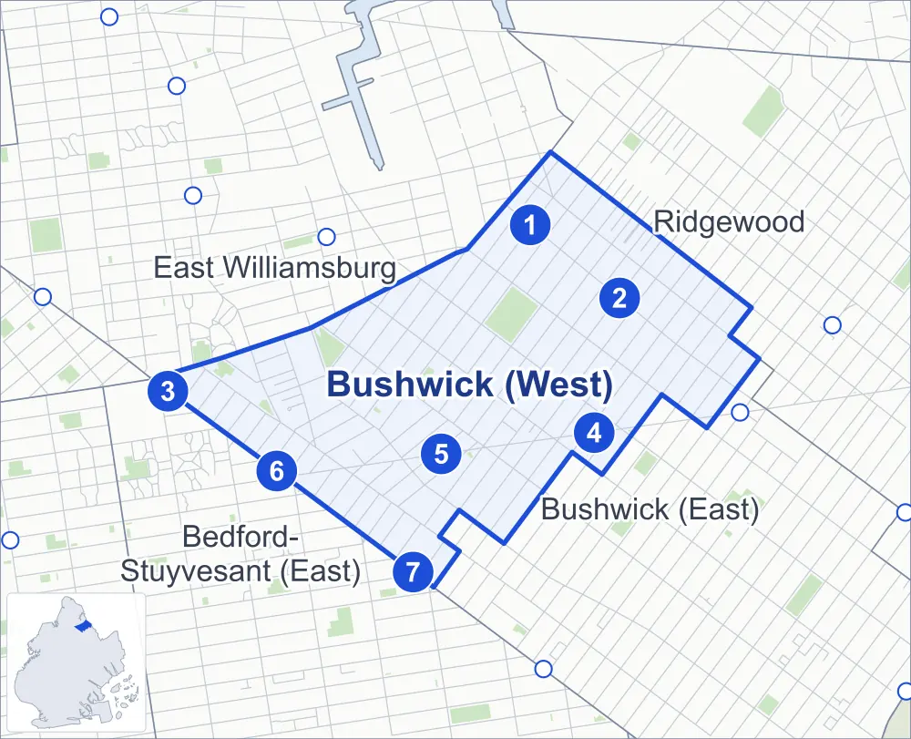
- Bushwick (West)
- A neighboring area
- Park
- A station in the list
- Another station
Neighborhood areas and streets: NYC Department of City Planning. Parks: NYC Parks. Stations: MTA.
Neighboring areas
- Ridgewood northeast
- Bushwick (East) southeast
- Bedford-Stuyvesant (East) southwest
- East Williamsburg northwest
Subway stations
- Jefferson St lines L
- DeKalb Av lines L
- Flushing Av lines J M accessible
- Knickerbocker Av lines M
- Central Av lines M
- Myrtle Av lines J M Z
- Kosciuszko St lines J
Getting around
Seven subway stations and buses on 16 routes stop in or at the edge of Bushwick (West).
- 7 subway stations
- 1 of them listed by the MTA as fully accessible
- 16 local bus routes
Local bus routes
- B13
- B15
- B38
- B43
- B46
- B47
- B54
- B57
- B60
- L90
- M90
- Q24
- T410
- T430
- T432
- T433
Safety record
Between 2021 and 2025, its corners averaged more police-reported crashes than the average Brooklyn corner.
- 3,558 police-reported crashes at its corners
- 19.4 a corner, on average
- 10.5 the average Brooklyn corner
- 2 corners with a clean record
Signal or safety changes on City record, at 45 of its corners
- Leading pedestrian intervals
- 24
- Accessible pedestrian signals
- 17
- Turn calming
- 10
- Safety Improvement Projects
- 3
- Barnes Dance all-way crossings
- 2
Camera tickets
In 2025 its corners had more school-zone speed camera tickets than red-light or bus-lane tickets.
- 0 red-light camera tickets
- 2,402 school-zone speed camera tickets at nine corners
- 0 bus-lane camera tickets
- Most speed tickets
- Flushing Avenue & Johnson Avenue, 631
People and homes
The 2020 Census counted 58,692 residents in Bushwick (West), about 70,700 per square mile.
- 23,507 homes, 2020 Census
- 5,917 homes added since April 2010, net, by City Planning's count
Half of its 4,122 residential lots hold buildings from 1931 or earlier, and 77% of them date from before 1940, by the City's tax lot records.
Parks and landmarks
- Parkland
- 12.1 acres of NYC Parks property
- The largest pieces
- Maria Hernandez Park (6.7 acres), Green Central Knoll (2.7 acres) and Fermi Playground (1.1 acres)
- Designated landmarks
- The William Ulmer Brewery: Engine and Machine House, the William Ulmer Brewery: Main Brewhouse and Addition, the William Ulmer Brewery: Office Building and 20th Precinct Police Station House and Stable, among others
Streets and trees
- Trees
- 3,949 in NYC Parks' records, most often thornless honeylocust, Japanese zelkova and pin oak
- Street with the most corners
- Myrtle Avenue, with 19 of the area's 183
- Height above sea level
- From 14 feet at Flushing Avenue & Wyckoff Avenue to 73 feet at Cypress Avenue & Dekalb Avenue
- Honorary street names
- 3 at its corners, enacted by local law
Schools and libraries
The City lists 18 schools and one library in Bushwick (West).
- Public schools
- 13
- Charter and private schools
- 5
- Library
- Dekalb Library
Bike share and public art
By the station list of October 3, 2026, 30 bike-share stations stand in Bushwick (West). The City's public art inventory lists one work in the area: Bushwick-Ridgewood Memorial (1921).
- 30 bike-share stations
- 1 work of public art
Public safety
How complaints are countedIn 2025 the NYPD recorded 805 major felonies at places in Bushwick (West).
Recorded by the NYPD at places in Bushwick (West)
- 779 major felonies in 2024
- 2,616 other felonies, misdemeanors and violations in 2025
In 2025, on the streets along the edge of Bushwick (West), the NYPD recorded another 267 major felonies. Counting the streets along its edge, in 2025 the NYPD recorded 18.3 major felonies for every thousand residents the 2020 Census counted in Bushwick (West).
- Police precinct
- 83rd
From January to June 2026 the NYPD recorded 429 major felonies at places in Bushwick (West), against 331 in the same months of 2025.
Sources: the NYPD's Complaint Data Historic, updated April 28, 2026, and Complaint Data Current (Year To Date), updated July 27, 2026, on NYC Open Data. Figures to June 30, 2026.
Street corners
- Beaver Street & Belvidere Street
- Beaver Street & Fayette Street
- Beaver Street & Locust Street
- Beaver Street & Park Street
- Bleecker Street & St Nicholas Avenue
- Bleecker Street & Wyckoff Avenue
- Broadway & Arion Place
- Broadway & Belvidere Street
- Broadway & Ellery Street
- Broadway & Lewis Avenue
- Broadway & Lewis Avenue at Locust Street
- Broadway & Melrose Street
- Broadway & Park Avenue
- Broadway & Patchen Avenue
- Broadway & Stockton Street
- Bushwick Avenue & Beaver Street
- Bushwick Avenue & Cedar Street
- Bushwick Avenue & Dodworth Street
- Bushwick Avenue & Garden Street
- Bushwick Avenue & Hart Street
- Bushwick Avenue & Jefferson Street
- Bushwick Avenue & Kosciuszko Street
- Bushwick Avenue & Lawton Street
- Bushwick Avenue & Melrose Street
- Bushwick Avenue & Montieth Street
- Bushwick Avenue & Noll Street
- Bushwick Avenue & Stanwix Street
- Bushwick Avenue & Stockholm Street
- Bushwick Avenue & Suydam Street
- Bushwick Avenue & Troutman Street
- Central Avenue & Cedar Street
- Central Avenue & Forrest Street
- Central Avenue & George Street
- Central Avenue & Harman Street
- Central Avenue & Himrod Street
- Central Avenue & Jefferson Street
- Central Avenue & Melrose Street
- Central Avenue & Noll Street
- Central Avenue & Stanhope Street
- Central Avenue & Starr Street
- Central Avenue & Stockholm Street
- Central Avenue & Suydam Street
- Central Avenue & Troutman Street
- Dekalb Avenue & Bushwick Avenue
- Dekalb Avenue & Central Avenue
- Dekalb Avenue & Evergreen Avenue
- Dekalb Avenue & Irving Avenue
- Dekalb Avenue & Knickerbocker Avenue
- Dekalb Avenue & Myrtle Avenue
- Dekalb Avenue & St Nicholas Avenue
- Dekalb Avenue & Wilson Avenue
- Dekalb Avenue & Wyckoff Avenue
- Ellery Street & Beaver Street
- Evergreen Avenue & Cedar Street
- Evergreen Avenue & George Street
- Evergreen Avenue & Harman Street
- Evergreen Avenue & Himrod Street
- Evergreen Avenue & Jefferson Street
- Evergreen Avenue & Melrose Street
- Evergreen Avenue & Noll Street
- Evergreen Avenue & Stockholm Street
- Evergreen Avenue & Suydam Street
- Evergreen Avenue & Troutman Street
- Flushing Avenue & Beaver Street
- Flushing Avenue & Central Avenue
- Flushing Avenue & Garden Street
- Flushing Avenue & Humboldt Street
- Flushing Avenue & Irving Avenue
- Flushing Avenue & Johnson Avenue
- Flushing Avenue & Morgan Avenue
- Flushing Avenue & Noll Street
- Flushing Avenue & Porter Avenue
- Flushing Avenue & Scott Avenue
- Flushing Avenue & St Nicholas Avenue
- Flushing Avenue & Stanwix Street
- Flushing Avenue & Thames Street
- Flushing Avenue & Vandervoort Place
- Flushing Avenue & Varick Avenue
- Flushing Avenue & Wyckoff Avenue
- Greene Avenue & Cypress Avenue
- Greene Avenue & Irving Avenue
- Greene Avenue & Knickerbocker Avenue
- Greene Avenue & St Nicholas Avenue
- Greene Avenue & Wilson Avenue
- Greene Avenue & Wyckoff Avenue
- Grove Street & St Nicholas Avenue
- Grove Street & Wyckoff Avenue
- Harman Street & Cypress Avenue
- Harman Street & St Nicholas Avenue
- Harman Street & Wyckoff Avenue
- Hart Street & Central Avenue
- Hart Street & Evergreen Avenue
- Hart Street & Irving Avenue
- Hart Street & Knickerbocker Avenue
- Hart Street & St Nicholas Avenue
- Hart Street & Wilson Avenue
- Hart Street & Wyckoff Avenue
- Himrod Street & St Nicholas Avenue
- Himrod Street & Wyckoff Avenue
- Irving Avenue & Bleecker Street
- Irving Avenue & Harman Street
- Irving Avenue & Himrod Street
- Irving Avenue & Jefferson Street
- Irving Avenue & Stanhope Street
- Irving Avenue & Starr Street
- Irving Avenue & Stockholm Street
- Irving Avenue & Troutman Street
- Jefferson Street & Scott Avenue
- Jefferson Street & St Nicholas Avenue
- Jefferson Street & Stanwix Street
- Jefferson Street & Wyckoff Avenue
- Knickerbocker Avenue & Bleecker Street
- Knickerbocker Avenue & George Street
- Knickerbocker Avenue & Harman Street
- Knickerbocker Avenue & Himrod Street
- Knickerbocker Avenue & Jefferson Street
- Knickerbocker Avenue & Melrose Street
- Knickerbocker Avenue & Stanhope Street
- Knickerbocker Avenue & Starr Street
- Knickerbocker Avenue & Stockholm Street
- Knickerbocker Avenue & Suydam Street
- Knickerbocker Avenue & Troutman Street
- Linden Street & St Nicholas Avenue
- Melrose Street & Stanwix Street
- Menahan Street & St Nicholas Avenue
- Menahan Street & Wyckoff Avenue
- Myrtle Avenue & Bleecker Street
- Myrtle Avenue & Bushwick Avenue
- Myrtle Avenue & Cedar Street
- Myrtle Avenue & Central Avenue
- Myrtle Avenue & Ditmars Street
- Myrtle Avenue & Evergreen Avenue
- Myrtle Avenue & Harman Street
- Myrtle Avenue & Hart Street
- Myrtle Avenue & Himrod Street
- Myrtle Avenue & Irving Avenue
- Myrtle Avenue & Knickerbocker Avenue
- Myrtle Avenue & Stanhope Street
- Myrtle Avenue & Stockholm Street
- Myrtle Avenue & Suydam Street
- Myrtle Avenue & Troutman Street
- Myrtle Avenue & Willoughby Avenue
- Myrtle Avenue & Willoughby Avenue at Charles Place
- Myrtle Avenue & Wilson Avenue
- Noll Street & Stanwix Street
- Stanhope Street & St Nicholas Avenue
- Stanhope Street & Wyckoff Avenue
- Stanwix Street & Forrest Street
- Stanwix Street & Montieth Street
- Stanwix Street & Renaissance Court
- Starr Street & St Nicholas Avenue
- Starr Street & Wyckoff Avenue
- Stockholm Street & St Nicholas Avenue
- Stockholm Street & Wyckoff Avenue
- Suydam Street & Cypress Avenue
- Suydam Street & Irving Avenue
- Suydam Street & St Nicholas Avenue
- Suydam Street & Wilson Avenue
- Suydam Street & Wyckoff Avenue
- Troutman Street & Cypress Avenue
- Troutman Street & St Nicholas Avenue
- Troutman Street & Wyckoff Avenue
- Willoughby Avenue & Bushwick Avenue
- Willoughby Avenue & Central Avenue
- Willoughby Avenue & Evergreen Avenue
- Willoughby Avenue & Irving Avenue
- Willoughby Avenue & Knickerbocker Avenue
- Willoughby Avenue & St Nicholas Avenue
- Willoughby Avenue & Wilson Avenue
- Willoughby Avenue & Wyckoff Avenue
- Wilson Avenue & George Street
- Wilson Avenue & Harman Street
- Wilson Avenue & Himrod Street
- Wilson Avenue & Jefferson Street
- Wilson Avenue & Melrose Street
- Wilson Avenue & Noll Street
- Wilson Avenue & Stanhope Street
- Wilson Avenue & Starr Street
- Wilson Avenue & Stockholm Street
- Wilson Avenue & Troutman Street
How the figures above are measured: Methodology.