East Williamsburg
Neighborhood · Brooklyn
Between Williamsburg and the Queens line, East Williamsburg spreads across north Brooklyn, with Greenpoint to the north and Bushwick to the south.
- 1.87 square miles
- 52,998 residents, 2020 Census
- 377 street corners
- 7 subway stations
- 14 bus routes
Its eastern section is an industrial district along Newtown Creek, a hub of large-scale industry since the early 1800s. Italian immigrants arrived in the second half of the 19th century, and the southern stretch of Graham Avenue, known as the Avenue of Puerto Rico, has anchored a Latin American community since the 1950s. It is home to the landmark Williamsburg Houses, completed in 1938 as one of the country's earliest modernist public housing developments, and Cooper Park, opened in the 1890s on the site of a glue works.
Sources: East Williamsburg, Brooklyn (Wikipedia); Williamsburg Houses (LP-2135), Designation List 348, June 24, 2003 (NYC Landmarks Preservation Commission); Cooper Park (NYC Parks); North Brooklyn Industry & Innovation Plan: Executive Summary (NYC Department of City Planning).
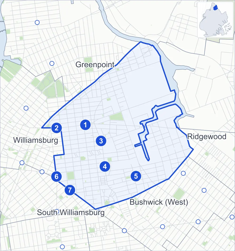
East Williamsburg borders five areas, and Graham Avenue and Humboldt Street hold more of its corners than any other street, 29 each of 378.
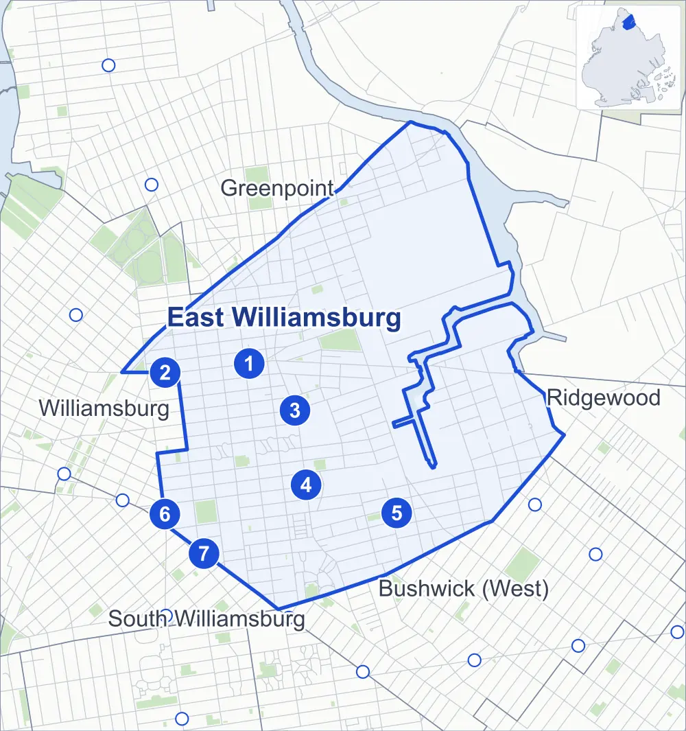
- East Williamsburg
- A neighboring area
- Park
- A station in the list
- Another station
Neighborhood areas and streets: NYC Department of City Planning. Parks: NYC Parks. Stations: MTA.
Neighboring areas
- Greenpoint north
- Ridgewood east
- Bushwick (West) southeast
- South Williamsburg southwest
- Williamsburg west
Subway stations
- Graham Av lines L
- Lorimer St lines L accessible
- Grand St lines L accessible
- Montrose Av lines L
- Morgan Av lines L
- Broadway lines G
- Lorimer St lines J M
Getting around
Seven subway stations and buses on 14 routes stop in or at the edge of East Williamsburg.
- 7 subway stations
- 2 of them listed by the MTA as fully accessible
- 14 local bus routes
Local bus routes
- B24
- B43
- B46
- B48
- B57
- B60
- L90
- Q54
- Q59
- T403
- T410
- T422
- T432
- T433
Safety record
Between 2021 and 2025, its corners averaged fewer police-reported crashes than the average Brooklyn corner.
- 3,859 police-reported crashes at its corners
- 10.2 a corner, on average
- 10.5 the average Brooklyn corner
- 31 corners with a clean record
Signal or safety changes on City record, at 77 of its corners
- Leading pedestrian intervals
- 55
- Accessible pedestrian signals
- 36
- Turn calming
- 14
- Barnes Dance all-way crossings
- 3
- Enhanced crossings
- 2
- Safety Improvement Projects
- 2
Camera tickets
In 2025 its corners had more school-zone speed camera tickets than red-light or bus-lane tickets.
- 0 red-light camera tickets
- 6,545 school-zone speed camera tickets at eight corners
- 0 bus-lane camera tickets
- Most speed tickets
- Lorimer Street & Meeker Avenue, 3,112
People and homes
The 2020 Census counted 52,998 residents in East Williamsburg, about 28,300 per square mile.
- 24,898 homes, 2020 Census
- 5,327 homes added since April 2010, net, by City Planning's count
Half of its 3,280 residential lots hold buildings from 1920 or earlier, and 75% of them date from before 1940, by the City's tax lot records.
NYCHA developments
NYCHA's Borinquen Plaza I, Borinquen Plaza II, Bushwick, Cooper Park and Hylan developments lie wholly or partly within East Williamsburg.
Parks and landmarks
- Parkland
- 18.8 acres of NYC Parks property
- The largest pieces
- Cooper Park (6.5 acres), Sternberg Park (4.2 acres) and Bushwick Playground (1.4 acres)
- Designated landmarks
- The Williamsburg Houses; 19th Police Precinct Station House and Stable; the Williamsburg Branch, Public National Bank of New York Building; and the Colored School No. 3, later Public School 69
Streets and trees
- Trees
- 4,430 in NYC Parks' records, most often London planetree, thornless honeylocust and pin oak
- Street with the most corners
- Graham Avenue, with 29 of the area's 378
- Height above sea level
- From 7 feet at Metropolitan Avenue & Vandervoort Avenue to 57 feet at Porter Avenue & Anthony Street
- Honorary street names
- 10 at its corners, enacted by local law
Schools and libraries
The City lists 17 schools and two libraries in East Williamsburg.
- Public schools
- 15
- Charter and private schools
- 2
- Libraries
- Bushwick Library and Leonard Library
Bike share and public art
By the station list of October 3, 2026, 38 bike-share stations stand in East Williamsburg. The City's public art inventory lists three works in the area: Father Giorgio Memorial (1954), Greenpoint World War II Memorial (1954) and Plaza Perch (2017).
- 38 bike-share stations
- 3 works of public art
Public safety
How complaints are countedIn 2025 the NYPD recorded 964 major felonies at places in East Williamsburg.
Recorded by the NYPD at places in East Williamsburg
- 962 major felonies in 2024
- 2,503 other felonies, misdemeanors and violations in 2025
In 2025, on the streets along the edge of East Williamsburg, the NYPD recorded another 176 major felonies. Counting the streets along its edge, in 2025 the NYPD recorded 21.5 major felonies for every thousand residents the 2020 Census counted in East Williamsburg.
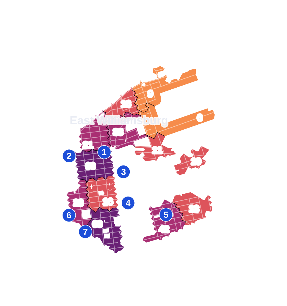
- 5 to 9
- 10 to 19
- 20 to 49
- 50 to 99
- 100 or more
- Not shaded: fewer than 5, held back under the rules in How complaints are counted, parks and public-housing grounds, and land in no patch
- Police precincts
- 90th (most of the area), 94th
From January to June 2026 the NYPD recorded 416 major felonies at places in East Williamsburg, against 442 in the same months of 2025.
Sources: the NYPD's Complaint Data Historic, updated April 28, 2026, and Complaint Data Current (Year To Date), updated July 27, 2026, on NYC Open Data. Figures to June 30, 2026.
Street corners
- Beadel Street & Debevoise Avenue
- Boerum Street & Bogart Street
- Boerum Street & Bushwick Place
- Boerum Street & White Street
- Bogart Street & Cook Street
- Bogart Street & Grattan Street
- Bogart Street & Harrison Place
- Bogart Street & Ingraham Street
- Bogart Street & Meadow Street
- Bogart Street & Thames Street
- Broadway & Flushing Avenue
- Broadway & Gerry Street
- Broadway & Lorimer Street
- Broadway & Lynch Street
- Broadway & Manhattan Avenue
- Broadway & McKibbin Street
- Broadway & Middleton Street
- Broadway & Throop Avenue
- Broadway & Wallabout Street
- Broadway & Walton Street
- Broadway & Whipple Street
- Brooklyn-Queens Expressway & Graham Avenue
- Brooklyn-Queens Expressway & Humboldt Street
- Brooklyn-Queens Expressway & Kingsland Avenue
- Brooklyn-Queens Expressway & Kosciuszko Bridge
- Brooklyn-Queens Expressway & Leonard Street
- Brooklyn-Queens Expressway & Lorimer Street
- Brooklyn-Queens Expressway & Manhattan Avenue
- Brooklyn-Queens Expressway & Morgan Avenue
- Brooklyn-Queens Expressway & North Henry Street
- Brooklyn-Queens Expressway & Union Avenue
- Brooklyn-Queens Expressway & Varick Avenue
- Bushwick Avenue & Ainslie Street
- Bushwick Avenue & Boerum Street
- Bushwick Avenue & Borinquen Plaza II Pedestrian Path
- Bushwick Avenue & Bushwick Court
- Bushwick Avenue & Cook Street
- Bushwick Avenue & Devoe Street
- Bushwick Avenue & Grand Street
- Bushwick Avenue & Johnson Avenue
- Bushwick Avenue & Maspeth Avenue
- Bushwick Avenue & Maujer Street
- Bushwick Avenue & McKibbin Street
- Bushwick Avenue & Meserole Street
- Bushwick Avenue & Metropolitan Avenue
- Bushwick Avenue & Montrose Avenue
- Bushwick Avenue & Moore Street
- Bushwick Avenue & Powers Street
- Bushwick Avenue & Scholes Street
- Bushwick Avenue & Seigel Street
- Bushwick Avenue & Stagg Street
- Bushwick Avenue & Ten Eyck Walk
- Bushwick Avenue & Varet Street
- Cherry Street & Brooklyn-Queens Expressway
- Conselyea Street & Woodpoint Road
- Cook Street & White Street
- Devoe Street & Catherine Street
- Devoe Street & Judge Street
- Devoe Street & Olive Street
- Division Place & Debevoise Avenue
- Evergreen Avenue & Cook Street
- Flushing Avenue & Bogart Street
- Flushing Avenue & Bushwick Avenue
- Flushing Avenue & Evergreen Avenue
- Flushing Avenue & Forrest Street
- Flushing Avenue & Gardner Avenue
- Flushing Avenue & Ingraham Street
- Flushing Avenue & Knickerbocker Avenue
- Flushing Avenue & Stewart Avenue
- Frost Street & Debevoise Avenue
- Frost Street & Vandervoort Avenue
- Frost Street & Woodpoint Road
- Gardner Avenue & Anthony Street
- Gardner Avenue & Cherry Street
- Gardner Avenue & Ingraham Street
- Gardner Avenue & Lombardy Street
- Gardner Avenue & Meadow Street
- Gardner Avenue & Randolph Street
- Gardner Avenue & Stagg Street
- Gardner Avenue & Thomas Street
- Gardner Avenue & Townsend Street
- Graham Avenue & Ainslie Street
- Graham Avenue & Boerum Street
- Graham Avenue & Conselyea Street
- Graham Avenue & Cook Street
- Graham Avenue & Debevoise Street
- Graham Avenue & Devoe Street
- Graham Avenue & Frost Street
- Graham Avenue & Herbert Street
- Graham Avenue & Jackson Street
- Graham Avenue & Johnson Avenue
- Graham Avenue & Maujer Street
- Graham Avenue & McKibbin Street
- Graham Avenue & Meserole Street
- Graham Avenue & Montrose Avenue
- Graham Avenue & Moore Street
- Graham Avenue & Powers Street
- Graham Avenue & Richardson Street
- Graham Avenue & Scholes Street
- Graham Avenue & Seigel Street
- Graham Avenue & Skillman Avenue
- Graham Avenue & Stagg Walk
- Graham Avenue & Ten Eyck Walk
- Graham Avenue & Varet Street
- Graham Avenue & Withers Street
- Grand Street & Catherine Street
- Grand Street & Gardner Avenue
- Grand Street & Graham Avenue
- Grand Street & Humboldt Street
- Grand Street & Leonard Street
- Grand Street & Metropolitan Avenue
- Grand Street & Morgan Avenue
- Grand Street & Olive Street
- Grand Street & Stewart Avenue
- Grand Street & Vandervoort Avenue
- Grand Street & Varick Avenue
- Grand Street & Varick Street
- Grand Street & Waterbury Street
- Grand Street Bridge & Grand Street
- Grand Street Bridge & Metropolitan Avenue
- Harrison Place & Porter Avenue
- Humboldt Street & Ainslie Street
- Humboldt Street & Boerum Street
- Humboldt Street & Borinquen Plaza II Pedestrian Path
- Humboldt Street & Conselyea Street
- Humboldt Street & Debevoise Street
- Humboldt Street & Devoe Street
- Humboldt Street & Frost Street
- Humboldt Street & Herbert Street
- Humboldt Street & Jackson Street
- Humboldt Street & Johnson Avenue
- Humboldt Street & Maspeth Avenue
- Humboldt Street & Maujer Street
- Humboldt Street & Meserole Street
- Humboldt Street & Metropolitan Avenue
- Humboldt Street & Montrose Avenue
- Humboldt Street & Moore Street
- Humboldt Street & Powers Street
- Humboldt Street & Richardson Street
- Humboldt Street & Scholes Street
- Humboldt Street & Seigel Street
- Humboldt Street & Skillman Avenue
- Humboldt Street & Stagg Walk
- Humboldt Street & Ten Eyck Walk
- Humboldt Street & Varet Street
- Humboldt Street & Withers Street
- Ingraham Street & Porter Avenue
- Jackson Street & Woodpoint Road
- Johnson Avenue & Bogart Street
- Johnson Avenue & Bushwick Place
- Johnson Avenue & Gardner Avenue
- Johnson Avenue & Porter Avenue
- Johnson Avenue & Scott Avenue
- Johnson Avenue & Stewart Avenue
- Johnson Avenue & Varick Avenue
- Johnson Avenue & White Street
- Kingsland Avenue & Beadel Street
- Kingsland Avenue & Division Place
- Kingsland Avenue & Frost Street
- Kingsland Avenue & Frost Street at Woodpoint Road
- Kingsland Avenue & Herbert Street
- Kingsland Avenue & Jackson Street
- Kingsland Avenue & Lombardy Street
- Kingsland Avenue & Maspeth Avenue
- Kingsland Avenue & Richardson Street
- Kingsland Avenue & Skillman Avenue
- Kingsland Avenue & Withers Street
- Knickerbocker Avenue & Grattan Street
- Knickerbocker Avenue & Harrison Place
- Knickerbocker Avenue & Ingraham Street
- Knickerbocker Avenue & Morgan Avenue
- Knickerbocker Avenue & Thames Street
- Kosciuszko Bridge & Gardner Avenue
- Kosciuszko Bridge & Scott Avenue
- Kosciuszko Bridge & Stewart Avenue
- Leonard Street & Ainslie Street
- Leonard Street & Boerum Street
- Leonard Street & Conselyea Street
- Leonard Street & Devoe Street
- Leonard Street & Jackson Street
- Leonard Street & Maujer Street
- Leonard Street & Meserole Street
- Leonard Street & Montrose Avenue
- Leonard Street & Moore Street
- Leonard Street & Powers Street
- Leonard Street & Scholes Street
- Leonard Street & Skillman Avenue
- Leonard Street & Stagg Street
- Leonard Street & Ten Eyck Street
- Leonard Street & Withers Street
- Lombardy Street & Porter Avenue
- Lorimer Street & Boerum Street
- Lorimer Street & Conselyea Street
- Lorimer Street & Devoe Street
- Lorimer Street & Grand Street
- Lorimer Street & Jackson Street
- Lorimer Street & McKibbin Street
- Lorimer Street & Meeker Avenue
- Lorimer Street & Meserole Street
- Lorimer Street & Montrose Avenue
- Lorimer Street & Scholes Street
- Lorimer Street & Skillman Avenue
- Lorimer Street & Stagg Street
- Lorimer Street & Ten Eyck Street
- Manhattan Avenue & Ainslie Street
- Manhattan Avenue & Boerum Street
- Manhattan Avenue & Conselyea Street
- Manhattan Avenue & Cook Street
- Manhattan Avenue & Devoe Street
- Manhattan Avenue & Frost Street
- Manhattan Avenue & Grand Street
- Manhattan Avenue & Jackson Street
- Manhattan Avenue & Johnson Avenue
- Manhattan Avenue & Maujer Street
- Manhattan Avenue & McKibbin Street
- Manhattan Avenue & Meeker Avenue
- Manhattan Avenue & Meserole Street
- Manhattan Avenue & Metropolitan Avenue
- Manhattan Avenue & Montrose Avenue
- Manhattan Avenue & Moore Street
- Manhattan Avenue & Powers Street
- Manhattan Avenue & Scholes Street
- Manhattan Avenue & Seigel Street
- Manhattan Avenue & Skillman Avenue
- Manhattan Avenue & Stagg Walk
- Manhattan Avenue & Ten Eyck Walk
- Manhattan Avenue & Varet Street
- Manhattan Avenue & Withers Street
- Maspeth Avenue & Conselyea Street
- Maspeth Avenue & Debevoise Avenue
- Maspeth Avenue & Olive Street
- Maspeth Avenue & Vandervoort Avenue
- Maujer Street & Waterbury Street
- McKibbin Street & Bogart Street
- McKibbin Street & McKibbin Court
- McKibbin Street & Seigel Court
- McKibbin Street & White Street
- Meadow Street & Waterbury Street
- Meeker Avenue & Brooklyn-Queens Expressway
- Meeker Avenue & Engert Avenue
- Meeker Avenue & Frost Street
- Meeker Avenue & Gardner Avenue
- Meeker Avenue & Graham Avenue at Brooklyn-Queens Expressway
- Meeker Avenue & Graham Avenue at Brooklyn-Queens Expressway (Exit 33)
- Meeker Avenue & Humboldt Street at Brooklyn-Queens Expressway
- Meeker Avenue & Humboldt Street at Brooklyn-Queens Expressway (Exit 33)
- Meeker Avenue & Leonard Street
- Meeker Avenue & Metropolitan Avenue at Rodney Street
- Meeker Avenue & Morgan Avenue
- Meeker Avenue & North 6th Street
- Meeker Avenue & North 7th Street
- Meeker Avenue & North Henry Street
- Meeker Avenue & Russell Street
- Meeker Avenue & Skillman Avenue
- Meeker Avenue & Stewart Avenue
- Meeker Avenue & Sutton Street
- Meeker Avenue & Union Avenue
- Meeker Avenue & Van Dam Street
- Meeker Avenue & Vandervoort Avenue at Cherry Street
- Meeker Avenue & Withers Street
- Meserole Street & Bogart Street
- Meserole Street & Bushwick Place
- Meserole Street & Gardner Avenue
- Meserole Street & Scott Avenue
- Meserole Street & Stewart Avenue
- Meserole Street & Varick Avenue
- Meserole Street & Waterbury Street
- Metropolitan Avenue & Catherine Street
- Metropolitan Avenue & Gardner Avenue
- Metropolitan Avenue & Graham Avenue
- Metropolitan Avenue & Leonard Street
- Metropolitan Avenue & Morgan Avenue
- Metropolitan Avenue & Olive Street
- Metropolitan Avenue & Orient Avenue
- Metropolitan Avenue & Scott Avenue
- Metropolitan Avenue & Stewart Avenue
- Metropolitan Avenue & Union Avenue
- Metropolitan Avenue & Vandervoort Avenue
- Metropolitan Avenue & Varick Avenue
- Metropolitan Avenue & Varick Street
- Monitor Street & Herbert Street
- Monitor Street & Richardson Street
- Montrose Avenue & Bushwick Place
- Moore Street & Bogart Street
- Moore Street & White Street
- Morgan Avenue & Anthony Street
- Morgan Avenue & Beadel Street
- Morgan Avenue & Devoe Street
- Morgan Avenue & Division Place
- Morgan Avenue & Frost Street
- Morgan Avenue & Grattan Street
- Morgan Avenue & Harrison Place
- Morgan Avenue & Ingraham Street
- Morgan Avenue & Jackson Street
- Morgan Avenue & Johnson Avenue
- Morgan Avenue & Lombardy Street
- Morgan Avenue & Maspeth Avenue
- Morgan Avenue & Maujer Street
- Morgan Avenue & Meadow Street
- Morgan Avenue & Meserole Street
- Morgan Avenue & Richardson Street
- Morgan Avenue & Scholes Street
- Morgan Avenue & Sharon Street
- Morgan Avenue & Skillman Avenue
- Morgan Avenue & Stagg Street
- Morgan Avenue & Ten Eyck Street
- Morgan Avenue & Thames Street
- Morgan Avenue & Withers Street
- North Henry Street & Herbert Street
- North Henry Street & Richardson Street
- Porter Avenue & Anthony Street
- Porter Avenue & Beadel Street
- Porter Avenue & Cherry Street
- Porter Avenue & Grattan Street
- Porter Avenue & Thames Street
- Powers Street & Catherine Street
- Powers Street & Judge Street
- Powers Street & Olive Street
- Randolph Street & Seneca Avenue
- Rewe Street & Ivy Hill Road
- Richardson Street & Debevoise Avenue
- Scholes Street & Bogart Street
- Scholes Street & Gardner Avenue
- Scholes Street & Scott Avenue
- Scholes Street & Stewart Avenue
- Scholes Street & Varick Avenue
- Scholes Street & Waterbury Street
- Scott Avenue & Randolph Street
- Scott Avenue & Townsend Street
- Seigel Street & Bogart Street
- Seigel Street & McKibbin Court
- Seigel Street & Seigel Court
- Seigel Street & White Street
- Sharon Street & Olive Street
- Skillman Avenue & Woodpoint Road
- Stagg Street & Bogart Street
- Stagg Street & Waterbury Street
- Stewart Avenue & Anthony Street
- Stewart Avenue & Cherry Street
- Stewart Avenue & Harrison Place
- Stewart Avenue & Ingraham Street
- Stewart Avenue & Lombardy Street
- Stewart Avenue & Meadow Street
- Stewart Avenue & Randolph Street
- Stewart Avenue & Stagg Street
- Stewart Avenue & Ten Eyck Street
- Stewart Avenue & Thomas Street
- Ten Eyck Street & Bogart Street
- Ten Eyck Street & Waterbury Street
- Thames Street & Vandervoort Place
- Union Avenue & Conselyea Street
- Union Avenue & Johnson Avenue
- Union Avenue & Scholes Street
- Union Avenue & South 4th Street
- Vandervoort Avenue & Anthony Street
- Vandervoort Avenue & Beadel Street
- Vandervoort Avenue & Division Place
- Vandervoort Avenue & Jackson Street
- Vandervoort Avenue & Lombardy Street
- Vandervoort Avenue & Rewe Street
- Vandervoort Avenue & Richardson Street
- Vandervoort Avenue & Withers Street
- Varet Street & Bogart Street
- Varet Street & White Street
- Varick Avenue & Anthony Street
- Varick Avenue & Cherry Street
- Varick Avenue & Grattan Street
- Varick Avenue & Harrison Place
- Varick Avenue & Ingraham Street
- Varick Avenue & Lombardy Street
- Varick Avenue & Meadow Street
- Varick Avenue & Randolph Street
- Varick Avenue & Stagg Street
- Varick Avenue & Ten Eyck Street
- Varick Avenue & Thames Street
- Varick Avenue & Thomas Street
- Withers Street & Woodpoint Road
How the figures above are measured: Methodology.