Williamsburg
Neighborhood · Brooklyn
Williamsburg runs along the East River south of Greenpoint, with Grand Street dividing its North Side from its South Side.
- 1.03 square miles
- 64,444 residents, 2020 Census
- 281 street corners
- 5 subway stations
- 20 bus routes
Named for Colonel Jonathan Williams, an engineer who surveyed the land after its purchase in 1802, it became a village in 1827 and a city in 1851 before joining Brooklyn in 1855; the Williamsburg Bridge, the world's longest suspension bridge when it opened in 1903, linked it to Manhattan. The landmark sugar refinery of 1881–84, once the tallest structure on Brooklyn's waterfront, marks its riverfront, and an arts movement born in the late 1980s made it a center for indie rock by the early 2000s.
Sources: Williamsburg, Brooklyn (Wikipedia); Williamsburg Bridge (NYC Department of Transportation); Havemeyers & Elder Filter, Pan & Finishing House (LP-2268), Designation List 396, September 25, 2007 (NYC Landmarks Preservation Commission).
Williamsburg borders five areas, and Kent Avenue and Wythe Avenue hold more of its corners than any other street, 29 each of 281.
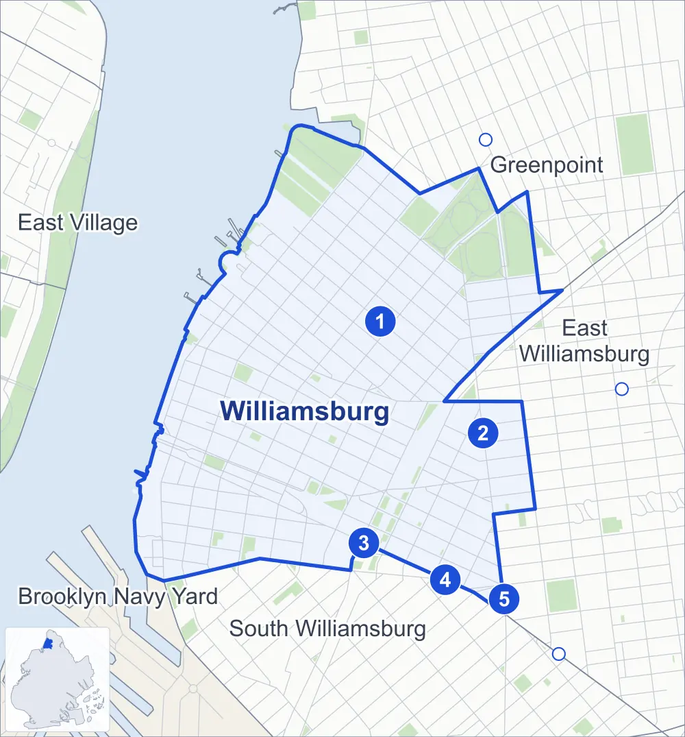
- Williamsburg
- A neighboring area
- Park
- A station in the list
- Another station
Neighborhood areas and streets: NYC Department of City Planning. Parks: NYC Parks. Stations: MTA.
Neighboring areas
- Greenpoint northeast
- East Williamsburg east
- South Williamsburg south
- Brooklyn Navy Yard southwest
- East Village northwest
Subway stations
- Bedford Av lines L accessible
- Lorimer St / Metropolitan Av lines G L accessible
- Marcy Av lines J M Z accessible
- Hewes St lines J M
- Broadway lines G
Getting around
Five subway stations and buses on 20 routes stop in or at the edge of Williamsburg.
- 5 subway stations
- 3 of them listed by the MTA as fully accessible
- 20 local bus routes
Local bus routes
- B24
- B32
- B39
- B43
- B44
- B44-SBS
- B46
- B48
- B60
- B62
- B67
- B106
- L90
- Q54
- Q59
- T403
- T410
- T422
- T432
- T433
Safety record
Between 2021 and 2025, its corners averaged fewer police-reported crashes than the average Brooklyn corner.
- 2,612 police-reported crashes at its corners
- 9.3 a corner, on average
- 10.5 the average Brooklyn corner
- 18 corners with a clean record
Signal or safety changes on City record, at 68 of its corners
- Leading pedestrian intervals
- 49
- Accessible pedestrian signals
- 34
- Turn calming
- 10
- Safety Improvement Projects
- 4
- Barnes Dance all-way crossings
- 3
- Enhanced crossings
- 1
Camera tickets
In 2025 its corners had more school-zone speed camera tickets than red-light or bus-lane tickets.
- 0 red-light camera tickets
- 13,172 school-zone speed camera tickets at five corners
- 0 bus-lane camera tickets
- Most speed tickets
- Rodney Street & Ainslie Street, 7,340
People and homes
The 2020 Census counted 64,444 residents in Williamsburg, about 62,600 per square mile.
- 32,444 homes, 2020 Census
- 13,703 homes added since April 2010, net, by City Planning's count
Half of its 2,809 residential lots hold buildings from 1910 or earlier, and 74% of them date from before 1940, by the City's tax lot records.
Parks and landmarks
- Parkland
- 70.4 acres of NYC Parks property
- The largest pieces
- McCarren Park (36.9 acres), Bushwick Inlet Park (22 acres) and North 5th Street Pier and Park (1.9 acres)
- Designated landmarks
- The Dime Savings Bank of Williamsburgh; the Williamsburgh Trust Company Building; the Smith, Gray & Company Building; and the Long Island Business College, among others
- Historic district
- Fillmore Place Historic District, wholly or partly within Williamsburg
Streets and trees
- Trees
- 5,907 in NYC Parks' records, most often thornless honeylocust, pin oak and Japanese zelkova
- Street with the most corners
- Kent Avenue, with 29 of the area's 281
- Height above sea level
- From 6 feet at Roebling Street & North 10th Street to 60 feet at Borinquen Place & Bike Path
- Honorary street names
- 16 at its corners, enacted by local law
Schools
The City lists 18 schools in Williamsburg.
- Public schools
- 9
- Charter and private schools
- 9
Bike share and public art
By the station list of October 3, 2026, 37 bike-share stations stand in Williamsburg. The City's public art inventory lists four works in the area, among them George Washington at Valley Forge (1906), Father Jerzy Popieluszko Monument (1990) and Bound Hands Rising Free (2000).
- 37 bike-share stations
- 4 works of public art
Public safety
How complaints are countedIn 2025 the NYPD recorded 895 major felonies at places in Williamsburg.
Recorded by the NYPD at places in Williamsburg
- 922 major felonies in 2024
- 2,069 other felonies, misdemeanors and violations in 2025
In 2025, on the streets along the edge of Williamsburg, the NYPD recorded another 113 major felonies. Counting the streets along its edge, in 2025 the NYPD recorded 15.6 major felonies for every thousand residents the 2020 Census counted in Williamsburg.
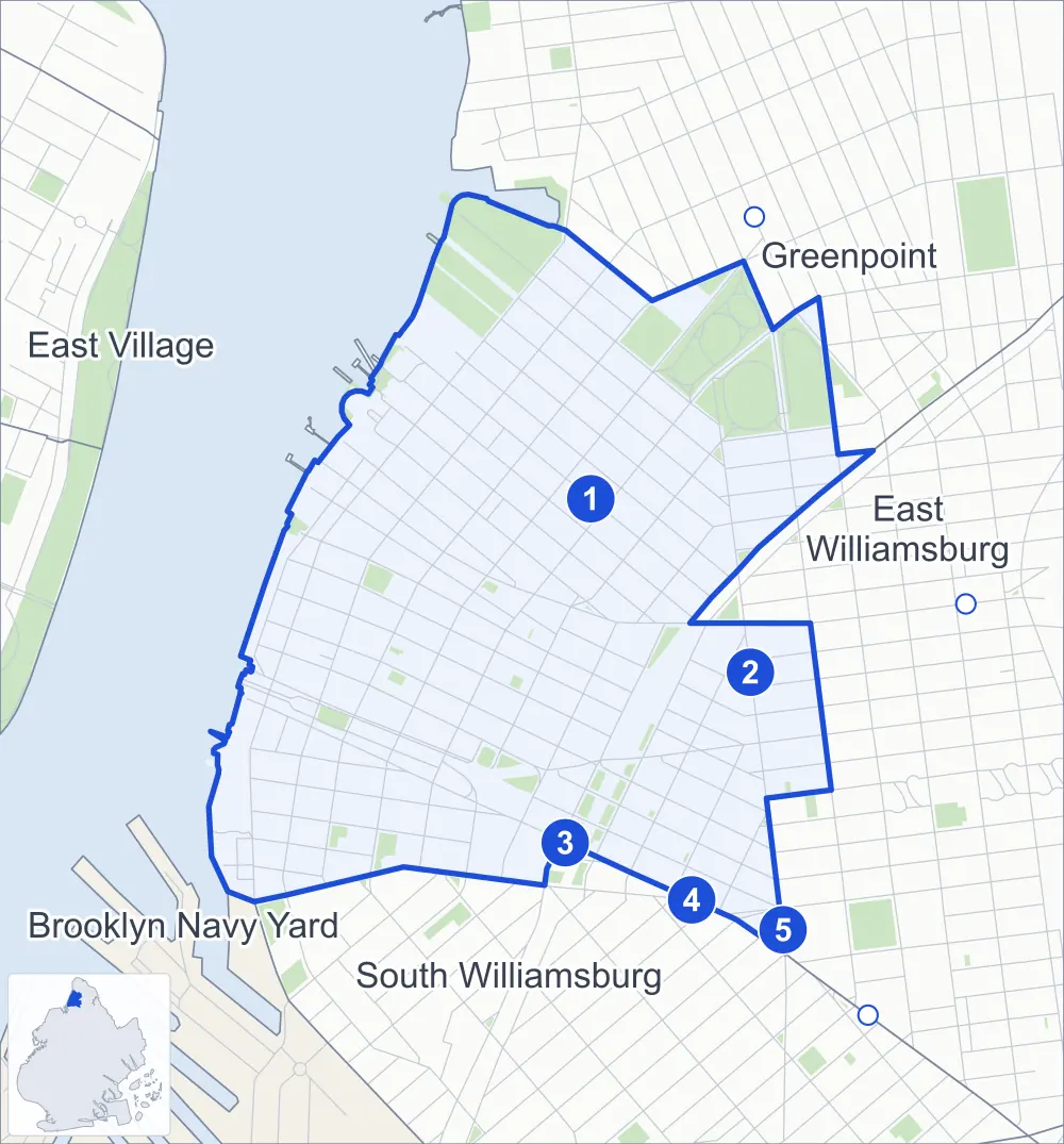
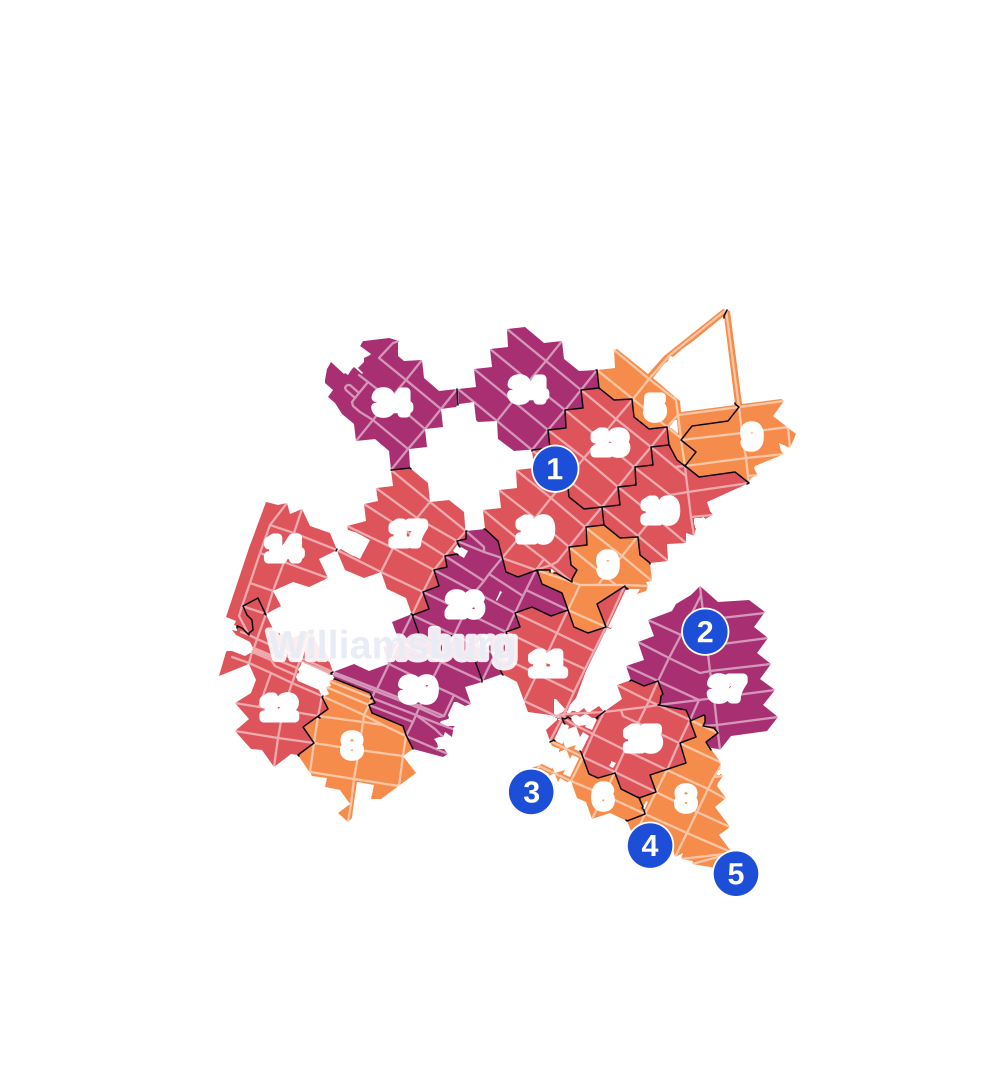
- 5 to 9
- 10 to 19
- 20 to 49
- 50 to 99
- 100 or more
- Not shaded: fewer than 5, held back under the rules in How complaints are counted, parks and public-housing grounds, and land in no patch
- Police precincts
- 90th (most of the area), 94th
From January to June 2026 the NYPD recorded 399 major felonies at places in Williamsburg, against 408 in the same months of 2025.
Sources: the NYPD's Complaint Data Historic, updated April 28, 2026, and Complaint Data Current (Year To Date), updated July 27, 2026, on NYC Open Data. Figures to June 30, 2026.
Street corners
- Bedford Avenue & Broadway
- Bedford Avenue & Broadway at South 6th Street
- Bedford Avenue & Division Avenue
- Bedford Avenue & Grand Street
- Bedford Avenue & Metropolitan Avenue
- Bedford Avenue & North 1st Street
- Bedford Avenue & North 3rd Street
- Bedford Avenue & North 4th Street
- Bedford Avenue & North 5th Street
- Bedford Avenue & North 6th Street
- Bedford Avenue & North 7th Street
- Bedford Avenue & North 8th Street
- Bedford Avenue & North 9th Street
- Bedford Avenue & North 10th Street
- Bedford Avenue & North 11th Street
- Bedford Avenue & North 12th Street
- Bedford Avenue & South 1st Street
- Bedford Avenue & South 2nd Street
- Bedford Avenue & South 3rd Street
- Bedford Avenue & South 4th Street
- Bedford Avenue & South 5th Street
- Bedford Avenue & South 8th Street
- Bedford Avenue & South 9th Street
- Bedford Avenue & South 10th Street
- Berry Street & Nassau Avenue
- Berry Street & North 1st Street
- Berry Street & North 3rd Street
- Berry Street & North 4th Street
- Berry Street & North 5th Street
- Berry Street & North 6th Street
- Berry Street & North 7th Street
- Berry Street & North 8th Street
- Berry Street & North 9th Street
- Berry Street & North 10th Street
- Berry Street & North 11th Street
- Berry Street & North 12th Street
- Berry Street & North 13th Street
- Berry Street & South 1st Street
- Berry Street & South 2nd Street
- Berry Street & South 3rd Street
- Berry Street & South 4th Street
- Berry Street & South 5th Street
- Berry Street & South 6th Street
- Berry Street & South 8th Street
- Berry Street & South 9th Street
- Berry Street & South 10th Street
- Berry Street & South 11th Street
- Borinquen Place & Bike Path
- Broadway & Berry Street
- Broadway & Driggs Avenue
- Broadway & Dunham Place
- Broadway & Havemeyer Street
- Broadway & Hewes Street
- Broadway & Hooper Street
- Broadway & Johnson Avenue
- Broadway & Kent Avenue
- Broadway & New Montrose Avenue
- Broadway & Rodney Street
- Broadway & Roebling Street
- Broadway & South 8th Street
- Broadway & Wythe Avenue
- Brooklyn-Queens Expressway & Borinquen Place
- Brooklyn-Queens Expressway & Metropolitan Avenue
- Brooklyn-Queens Expressway & South 3rd Street
- Brooklyn-Queens Expressway & South 4th Street
- Brooklyn-Queens Expressway & South 5th Street
- Division Avenue & Clymer Street
- Division Avenue & Lee Avenue
- Division Avenue & Wilson Street
- Driggs Avenue & Fillmore Place
- Driggs Avenue & North 1st Street
- Driggs Avenue & North 4th Street
- Driggs Avenue & North 5th Street
- Driggs Avenue & North 6th Street
- Driggs Avenue & North 7th Street
- Driggs Avenue & North 8th Street
- Driggs Avenue & North 9th Street
- Driggs Avenue & North 10th Street
- Driggs Avenue & North 11th Street
- Driggs Avenue & North 12th Street
- Driggs Avenue & South 1st Street
- Driggs Avenue & South 2nd Street
- Driggs Avenue & South 3rd Street
- Driggs Avenue & South 4th Street
- Driggs Avenue & South 5th Street
- Driggs Avenue & South 8th Street
- Driggs Avenue & South 9th Street
- Driggs Avenue & Union Avenue
- Frost Street & North 10th Street
- Grand Street & Berry Street
- Grand Street & Driggs Avenue
- Grand Street & Havemeyer Street
- Grand Street & Hooper Street
- Grand Street & Keap Street
- Grand Street & River Street
- Grand Street & Rodney Street
- Grand Street & Roebling Street
- Grand Street & Union Avenue
- Grand Street & Wythe Avenue
- Havemeyer Street & Hope Street
- Havemeyer Street & North 5th Street
- Havemeyer Street & North 6th Street
- Havemeyer Street & North 8th Street
- Havemeyer Street & Withers Street
- Hewes Street & Stagg Street
- Keap Street & Ainslie Street
- Keap Street & Borinquen Place
- Keap Street & Hope Street
- Keap Street & South 1st Street
- Keap Street & South 2nd Street
- Keap Street & South 5th Street
- Kent Avenue & Franklin Street
- Kent Avenue & Gantry Road
- Kent Avenue & Grand Street
- Kent Avenue & Metropolitan Avenue
- Kent Avenue & Mollenhauer Drive
- Kent Avenue & North 1st Street
- Kent Avenue & North 3rd Street
- Kent Avenue & North 4th Street
- Kent Avenue & North 5th Street
- Kent Avenue & North 6th Street
- Kent Avenue & North 7th Street
- Kent Avenue & North 8th Street
- Kent Avenue & North 9th Street
- Kent Avenue & North 10th Street
- Kent Avenue & North 11th Street
- Kent Avenue & North 12th Street
- Kent Avenue & North 13th Street
- Kent Avenue & South 1st Street
- Kent Avenue & South 2nd Street
- Kent Avenue & South 3rd Street
- Kent Avenue & South 4th Street
- Kent Avenue & South 5th Street
- Kent Avenue & South 6th Street
- Kent Avenue & South 8th Street
- Kent Avenue & South 9th Street
- Kent Avenue & South 10th Street
- Kent Avenue & South 11th Street
- Leonard Street & Richardson Street
- Lorimer Street & Ainslie Street
- Lorimer Street & Bayard Street
- Lorimer Street & Driggs Avenue
- Lorimer Street & Frost Street
- Lorimer Street & Maujer Street
- Lorimer Street & Meeker Avenue at Withers Street
- Lorimer Street & Metropolitan Avenue
- Lorimer Street & Powers Street
- Lorimer Street & Richardson Street
- Manhattan Avenue & Driggs Avenue
- Marcy Avenue & Bike Path
- Marcy Avenue & Brooklyn-Queens Expressway
- Marcy Avenue & Grand Street
- Marcy Avenue & Hope Street
- Marcy Avenue & Metropolitan Avenue
- Marcy Avenue & South 1st Street
- Marcy Avenue & South 2nd Street
- Marcy Avenue & South 4th Street
- Marcy Avenue & South 5th Street
- Marcy Avenue & South 9th Street
- Meeker Avenue & Jackson Street
- Meeker Avenue & Metropolitan Avenue
- Meeker Avenue & North 8th Street
- Meeker Avenue & Union Avenue at Brooklyn-Queens Expressway
- Metropolitan Avenue & Berry Street
- Metropolitan Avenue & Driggs Avenue
- Metropolitan Avenue & Havemeyer Street
- Metropolitan Avenue & North 3rd Street
- Metropolitan Avenue & North 4th Street
- Metropolitan Avenue & North 5th Street
- Metropolitan Avenue & River Street
- Metropolitan Avenue & Roebling Street
- Metropolitan Avenue & Wythe Avenue
- Mollenhauer Drive & Gantry Road
- North 5th Street & North 4th Place
- North 7th Street & Havemeyer Street
- North 7th Street & North 6th Place
- River Street & North 1st Street
- River Street & North 3rd Street
- Rodney Street & Ainslie Street
- Rodney Street & Borinquen Place
- Rodney Street & Hope Street
- Rodney Street & South 1st Street
- Rodney Street & South 3rd Street
- Rodney Street & South 5th Street
- Roebling Street & Division Avenue
- Roebling Street & Fillmore Place
- Roebling Street & Hope Street
- Roebling Street & North 4th Street
- Roebling Street & North 5th Street
- Roebling Street & North 6th Street
- Roebling Street & North 7th Street
- Roebling Street & North 8th Street
- Roebling Street & North 9th Street
- Roebling Street & North 10th Street
- Roebling Street & North 11th Street
- Roebling Street & South 1st Street
- Roebling Street & South 2nd Street
- Roebling Street & South 3rd Street
- Roebling Street & South 8th Street
- Roebling Street & South 9th Street
- Roebling Street & Williamsburg Bridge
- South 1st Street & Borinquen Place
- South 1st Street & Havemeyer Street
- South 1st Street & Hooper Street
- South 1st Street & Maujer Street
- South 1st Street & River Street
- South 2nd Street & Borinquen Place
- South 2nd Street & Havemeyer Street
- South 2nd Street & Hooper Street
- South 2nd Street & River Street
- South 3rd Street & Brooklyn-Queens Expressway
- South 3rd Street & Havemeyer Street
- South 3rd Street & Hewes Street
- South 3rd Street & Hooper Street
- South 3rd Street & Keap Street
- South 3rd Street & River Street
- South 4th Street & Havemeyer Street
- South 4th Street & Havemeyer Street at Borinquen Place
- South 4th Street & Hewes Street
- South 4th Street & Hooper Street
- South 4th Street & Keap Street
- South 4th Street & River Street
- South 4th Street & Rodney Street
- South 4th Street & Roebling Street
- South 4th Street & South 5th Place
- South 4th Street & Williamsburg Bridge
- South 5th Street & Havemeyer Street
- South 5th Street & Hewes Street
- South 5th Street & Hooper Street
- South 5th Street & River Street
- South 5th Street & South 5th Place
- South 6th Street & Dunham Place
- Union Avenue & Ainslie Street
- Union Avenue & Devoe Street
- Union Avenue & Frost Street
- Union Avenue & Jackson Street
- Union Avenue & Keap Street
- Union Avenue & Maujer Street
- Union Avenue & North 10th Street
- Union Avenue & North 11th Street
- Union Avenue & North 12th Street
- Union Avenue & Powers Street
- Union Avenue & Richardson Street
- Union Avenue & Roebling Street
- Union Avenue & South 1st Street
- Union Avenue & South 2nd Street
- Union Avenue & South 5th Street
- Union Avenue & Stagg Street
- Union Avenue & Ten Eyck Street
- Union Avenue & Withers Street
- Williamsburg Bridge & Bedford Avenue
- Williamsburg Bridge & Berry Street
- Williamsburg Bridge & Brooklyn-Queens Expressway
- Williamsburg Bridge & Driggs Avenue
- Williamsburg Bridge & Kent Avenue
- Williamsburg Bridge & Wythe Avenue
- Wythe Avenue & Division Avenue
- Wythe Avenue & North 1st Street
- Wythe Avenue & North 3rd Street
- Wythe Avenue & North 4th Street
- Wythe Avenue & North 5th Street
- Wythe Avenue & North 6th Street
- Wythe Avenue & North 7th Street
- Wythe Avenue & North 8th Street
- Wythe Avenue & North 9th Street
- Wythe Avenue & North 10th Street
- Wythe Avenue & North 11th Street
- Wythe Avenue & North 12th Street
- Wythe Avenue & North 13th Street
- Wythe Avenue & North 14th Street
- Wythe Avenue & South 1st Street
- Wythe Avenue & South 2nd Street
- Wythe Avenue & South 3rd Street
- Wythe Avenue & South 4th Street
- Wythe Avenue & South 5th Street
- Wythe Avenue & South 6th Street
- Wythe Avenue & South 8th Street
- Wythe Avenue & South 9th Street
- Wythe Avenue & South 10th Street
- Wythe Avenue & South 11th Street
- Wythe Avenue & Wythe Lane
How the figures above are measured: Methodology.