East Village
Neighborhood · Manhattan
East of the Bowery and Third Avenue, between Houston and 14th Streets, the East Village takes in Alphabet City and Little Ukraine.
- 0.68 square miles
- 71,436 residents, 2020 Census
- 123 street corners
- 5 subway stations
- 14 bus routes
Peter Stuyvesant's farm lay here in the 1600s, and 19th-century German-speaking immigrants made it part of Kleindeutschland, or Little Germany; the East Village name took hold in the 1960s. Tompkins Square Park, acquired by the city in 1834, honors Governor Daniel D. Tompkins, and the Cooper Union, founded by Peter Cooper in 1859, stands on Cooper Square. First Houses, built in 1935 and 1936, was the nation's first public housing project, and the neighborhood later nurtured many art movements and theaters such as La MaMa.
Sources: East Village, Manhattan (Wikipedia); Tompkins Square Park (NYC Parks); History (The Cooper Union).
East Village borders five areas.
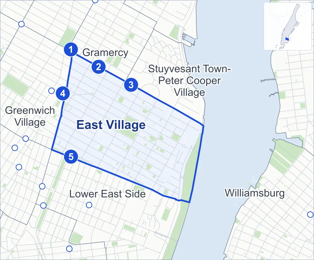
- East Village
- A neighboring area
- Park
- A station in the list
- Another station
Neighborhood areas and streets: NYC Department of City Planning. Parks: NYC Parks. Stations: MTA.
Neighboring areas
- Stuyvesant Town-Peter Cooper Village northeast
- Williamsburg southeast
- Lower East Side south
- Greenwich Village northwest
- Gramercy northwest
Subway stations
- 14 St-Union Sq lines 4 5 6
- 3 Av lines L
- 1 Av lines L accessible
- Astor Pl lines 6
- 2 Av lines F
Getting around
Five subway stations and buses on 14 routes stop in or at the edge of East Village.
- 5 subway stations
- 1 of them listed by the MTA as fully accessible
- 14 local bus routes
Local bus routes
- L92
- M1
- M2
- M3
- M8
- M9
- M14A-SBS
- M14D-SBS
- M15
- M15-SBS
- M21
- M101
- M102
- M103
Safety record
Between 2021 and 2025, its corners averaged fewer police-reported crashes than the average Manhattan corner.
- 1,511 police-reported crashes at its corners
- 12.3 a corner, on average
- 13.4 the average Manhattan corner
- 6 corners with a clean record
Signal or safety changes on City record, at 56 of its corners
- Leading pedestrian intervals
- 41
- Accessible pedestrian signals
- 20
- Turn calming
- 16
- Barnes Dance all-way crossings
- 11
- Safety Improvement Projects
- 2
Camera tickets
In 2025 its corners had more school-zone speed camera tickets than bus-lane or red-light tickets.
- 1,852 red-light camera tickets at one corner
- 11,282 school-zone speed camera tickets at six corners
- 6,609 bus-lane camera tickets at two corners
- Most red-light tickets
- 2nd Avenue & East Houston Street, 1,852
- Most speed tickets
- Avenue C & East Houston Street, 7,913
- Most bus-lane tickets
- 1st Avenue & St Marks Place, 6,026
People and homes
The 2020 Census counted 71,436 residents in East Village, about 105,100 per square mile.
- 38,205 homes, 2020 Census
- 2,032 homes added since April 2010, net, by City Planning's count
Half of its 1,929 residential lots hold buildings from 1900 or earlier, and 88% of them date from before 1940, by the City's tax lot records.
NYCHA developments
NYCHA's Bracetti Plaza, First Houses, Lower East Side II, Lower East Side III, Lower East Side Rehab (Group 5), Meltzer Tower, Riis, Riis II and Wald developments lie wholly or partly within East Village.
- Bracetti Plaza
- Within East Village
- First Houses
- Within East Village
- Lower East Side II
- Within East Village
- Lower East Side III
- Within East Village; privately managed
- Lower East Side Rehab (Group 5)
- Within East Village
- Meltzer Tower
- Within East Village
- Riis
- Within East Village
- Riis II
- Within East Village
- Wald
- Within East Village
Parks and landmarks
- Parkland
- 39.9 acres of NYC Parks property
- The largest pieces
- John V. Lindsay East River Park (18.5 acres), Tompkins Square Park (10.5 acres) and Dry Dock Playground (1.5 acres)
- Designated landmarks
- The First Houses, the Wheatsworth Bakery Building, the Public National Bank of New York Building and the Tompkins Square Lodging House, among others
- Historic districts
- East 10th Street, St. Mark's and St. Mark's Extension, wholly or partly within East Village
Streets and trees
- Trees
- 4,108 in NYC Parks' records, most often thornless honeylocust, pin oak and Japanese pagoda tree
- Street with the most corners
- 1st Avenue, with 14 of the area's 123
- Height above sea level
- From 6 feet at Avenue C & East 13th Street to 46 feet at East 13th Street & 4th Avenue
- Honorary street names
- 6 at its corners, enacted by local law
Schools and libraries
The City lists 18 schools and two libraries in East Village.
- Public schools
- 12
- Charter and private schools
- 6
- Libraries
- Ottendorfer Library and Tompkins Square Library
Bike share and public art
By the station list of October 3, 2026, 38 bike-share stations stand in East Village. The City's public art inventory lists four works in the area, among them Samuel Sullivan Cox (1891), Temperance Fountain (1891) and Peter Cooper (1897).
- 38 bike-share stations
- 4 works of public art
Public safety
How complaints are countedIn 2025 the NYPD recorded 895 major felonies at places in the East Village.
Recorded by the NYPD at places in the East Village
- 947 major felonies in 2024
- 2,596 other felonies, misdemeanors and violations in 2025
In 2025, on the streets along the edge of the East Village, the NYPD recorded another 305 major felonies. Counting the streets along its edge, in 2025 the NYPD recorded 16.8 major felonies for every thousand residents the 2020 Census counted in the East Village.
- Police precincts
- 9th (most of the area), 7th
From January to June 2026 the NYPD recorded 372 major felonies at places in the East Village, against 445 in the same months of 2025.
Sources: the NYPD's Complaint Data Historic, updated April 28, 2026, and Complaint Data Current (Year To Date), updated July 27, 2026, on NYC Open Data. Figures to June 30, 2026.
Street corners
- 1st Avenue & East 1st Street
- 1st Avenue & East 2nd Street
- 1st Avenue & East 3rd Street
- 1st Avenue & East 4th Street
- 1st Avenue & East 5th Street
- 1st Avenue & East 6th Street
- 1st Avenue & East 7th Street
- 1st Avenue & East 9th Street
- 1st Avenue & East 10th Street
- 1st Avenue & East 11th Street
- 1st Avenue & East 12th Street
- 1st Avenue & East 13th Street
- 1st Avenue & East Houston Street
- 1st Avenue & St Marks Place
- 2nd Avenue & East 1st Street
- 2nd Avenue & East 2nd Street
- 2nd Avenue & East 3rd Street
- 2nd Avenue & East 4th Street
- 2nd Avenue & East 5th Street
- 2nd Avenue & East 6th Street
- 2nd Avenue & East 7th Street
- 2nd Avenue & East 9th Street
- 2nd Avenue & East 10th Street
- 2nd Avenue & East 11th Street
- 2nd Avenue & East 12th Street
- 2nd Avenue & East 13th Street
- 2nd Avenue & East Houston Street
- 2nd Avenue & St Marks Place
- 3rd Avenue & East 9th Street
- 3rd Avenue & East 10th Street
- 3rd Avenue & East 11th Street
- 3rd Avenue & East 12th Street
- 3rd Avenue & East 13th Street
- 3rd Avenue & St Marks Place
- 3rd Avenue & Stuyvesant Street
- Avenue A & East 5th Street
- Avenue A & St Marks Place
- Avenue C & East 3rd Street
- Avenue C & East 5th Street
- Avenue C & East 7th Street
- Avenue C & East 8th Street
- Avenue C & East 13th Street
- Avenue C & East Houston Street
- Avenue D & East 5th Street
- Avenue D & Pedestrian Path
- Bleecker Street & Bowery
- Bowery & East 1st Street
- Cooper Square & Stable Court
- East 1st Street & Extra Place
- East 2nd Street & Avenue A
- East 2nd Street & Avenue B
- East 2nd Street & Avenue C
- East 2nd Street & East Houston Street
- East 3rd Street & Avenue A
- East 3rd Street & Avenue B
- East 3rd Street & Avenue D
- East 4th Street & Avenue A
- East 4th Street & Avenue B
- East 4th Street & Avenue C
- East 4th Street & Avenue D
- East 5th Street & Avenue B
- East 5th Street & Cooper Square
- East 6th Street & Avenue A
- East 6th Street & Avenue B
- East 6th Street & Avenue C
- East 6th Street & Avenue D
- East 6th Street & Cooper Square
- East 6th Street & Taras Shevchenko Place
- East 7th Street & Avenue A
- East 7th Street & Avenue B
- East 7th Street & Avenue D
- East 7th Street & Cooper Square
- East 7th Street & Taras Shevchenko Place
- East 8th Street & 4th Avenue
- East 8th Street & Avenue B
- East 8th Street & Avenue D
- East 9th Street & Avenue A
- East 9th Street & Avenue B
- East 9th Street & Avenue C
- East 9th Street & Avenue D
- East 9th Street & Stuyvesant Street
- East 10th Street & Avenue A
- East 10th Street & Avenue B
- East 10th Street & Avenue C
- East 10th Street & Avenue D
- East 10th Street & Stuyvesant Street
- East 10th Street & Szold Place
- East 11th Street & 4th Avenue
- East 11th Street & Avenue A
- East 11th Street & Avenue B
- East 11th Street & Avenue C
- East 11th Street & Szold Place
- East 12th Street & 4th Avenue
- East 12th Street & Avenue A
- East 12th Street & Avenue B
- East 12th Street & Avenue C
- East 12th Street & Avenue D
- East 12th Street & Szold Place
- East 13th Street & 4th Avenue
- East 13th Street & Avenue A
- East 13th Street & Avenue B
- East 13th Street & Avenue D
- East 14th Street & Avenue B
- East 14th Street & Avenue C
- East 14th Street & Avenue D
- East Houston Street & Avenue D
- East Houston Street & Clinton Street
- East Houston Street & Ludlow Street
- East Houston Street & Mangin Street
- East Houston Street & Norfolk Street
- East Houston Street & Orchard Street
- East Houston Street & Suffolk Street
- East River Esplanade & E Houston Street Pedestrian Overpass
- East River Esplanade & East 6th Street Pedestrian Bridge Over FDR Drive
- East River Esplanade & East River Park Path at East 10th Street Pedestrian Overpass
- FDR Drive & East 4th Walk
- FDR Drive & East 5th Walk
- FDR Drive & East 6th Street
- FDR Drive & East 6th Street Pedestrian Bridge Over FDR Drive
- FDR Drive & East 10th Street
- FDR Drive & East 10th Street Pedestrian Overpass
- FDR Drive & East Houston Street
- FDR Drive & East Houston Street at E Houston Street Pedestrian Overpass
How the figures above are measured: Methodology.