Greenwich Village
Neighborhood · Manhattan
Greenwich Village spreads around Washington Square Park, between Houston and 14th Streets.
- 0.38 square miles
- 34,147 residents, 2020 Census
- 97 street corners
- 6 subway stations
- 22 bus routes
Its name traces to Groenwijck, Dutch for green district, and it grew from a rural hamlet north of the colonial town; in 1822 a yellow fever epidemic sent New Yorkers out to the village, and many stayed. Washington Square became a military parade ground in 1826 and a public park the next year, and Stanford White's marble arch went up in the 1890s beside New York University, in the Village since the 1830s. After 1910 the Village drew writers, artists and bohemians, followed by Beat writers in the 1950s and folk musicians in the 1960s.
Sources: Washington Square Park (NYC Parks); Greenwich Village (Encyclopaedia Britannica); Greenwich Village (Wikipedia).
Greenwich Village borders four areas, and Broadway holds more of its corners than any other street, 15 of 97.
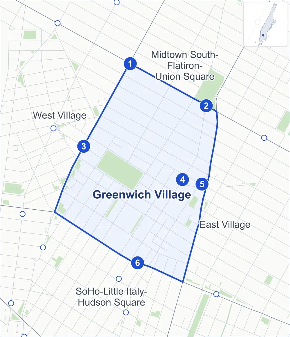
- Greenwich Village
- A neighboring area
- Park
- A station in the list
- Another station
Neighborhood areas and streets: NYC Department of City Planning. Parks: NYC Parks. Stations: MTA.
Neighboring areas
- Midtown South-Flatiron-Union Square north
- East Village east
- SoHo-Little Italy-Hudson Square south
- West Village northwest
Subway stations
- 6 Av lines L accessible
- 14 St-Union Sq lines 4 5 6 L
- W 4 St-Wash Sq lines A B C D E F M accessible
- 8 St-NYU lines R W
- Astor Pl lines 6
- Bleecker St / Broadway-Lafayette St lines 6 B D F M accessible
Getting around
Six subway stations and buses on 22 routes stop in or at the edge of Greenwich Village.
- 6 subway stations
- 3 of them listed by the MTA as fully accessible
- 11 local bus routes
- 11 express bus routes
Local bus routes
- L92
- M1
- M2
- M3
- M8
- M14A-SBS
- M14D-SBS
- M21
- M55
- M103
- T232
Express bus routes
- SIM1
- SIM1C
- SIM3C
- SIM4C
- SIM7
- SIM9
- SIM33
- SIM33C
- SIM34
- X27
- X28
Safety record
Between 2021 and 2025, its corners averaged fewer police-reported crashes than the average Manhattan corner.
- 964 police-reported crashes at its corners
- 9.9 a corner, on average
- 13.4 the average Manhattan corner
- 5 corners with a clean record
Signal or safety changes on City record, at 37 of its corners
- Leading pedestrian intervals
- 21
- Accessible pedestrian signals
- 13
- Barnes Dance all-way crossings
- 6
- Turn calming
- 5
- Enhanced crossings
- 5
- Safety Improvement Projects
- 2
Camera tickets
In 2025 its corners had more bus-lane camera tickets than school-zone speed or red-light tickets.
- 0 red-light camera tickets
- 3,235 school-zone speed camera tickets at three corners
- 25,070 bus-lane camera tickets at three corners
- Most speed tickets
- East 3rd Street & Bowery, 1,978
- Most bus-lane tickets
- East 14th Street & University Place, 10,980
People and homes
The 2020 Census counted 34,147 residents in Greenwich Village, about 89,900 per square mile.
- 20,097 homes, 2020 Census
- 441 homes added since April 2010, net, by City Planning's count
Half of its 854 residential lots hold buildings from 1889 or earlier, and 90% of them date from before 1940, by the City's tax lot records.
Parks and landmarks
- Parkland
- 12.4 acres of NYC Parks property
- The largest pieces
- Washington Square Park (9.7 acres), William F. Passannante Ballfield (0.6 acre) and Fiorello La Guardia Park (0.5 acre)
- Designated landmarks
- The Brown Building (originally Asch Building), the Judson Memorial Church, the Grace Church and the Judson Hall, among others
- Historic districts
- Greenwich Village, MacDougal-Sullivan Gardens, NoHo, NoHo Extension, Noho East and South Village, wholly or partly within Greenwich Village
Streets and trees
- Trees
- 1,693 in NYC Parks' records, most often thornless honeylocust, maidenhair tree and London planetree
- Street with the most corners
- Broadway, with 15 of the area's 97
- Height above sea level
- From 17 feet at Avenue of the Americas & Greenwich Avenue to 45 feet at East Houston Street & Mott Street
- Honorary street names
- 9 at its corners, enacted by local law
Schools
The City lists five schools in Greenwich Village.
- Public schools
- 2
- Charter and private schools
- 3
Bike share and public art
By the station list of October 3, 2026, 19 bike-share stations stand in Greenwich Village. The City's public art inventory lists seven works in the area, among them Giuseppe Garibaldi (1888), Alexander Lyman Holley (1890) and Washington Square Arch (1895).
- 19 bike-share stations
- 7 works of public art
Places the City draws by name in this area: NoHo and Little Italy.
Public safety
How complaints are countedIn 2025 the NYPD recorded 677 major felonies at places in Greenwich Village.
Recorded by the NYPD at places in Greenwich Village
- 745 major felonies in 2024
- 1,667 other felonies, misdemeanors and violations in 2025
In 2025, on the streets along the edge of Greenwich Village, the NYPD recorded another 364 major felonies. Counting the streets along its edge, in 2025 the NYPD recorded 30.5 major felonies for every thousand residents the 2020 Census counted in Greenwich Village.
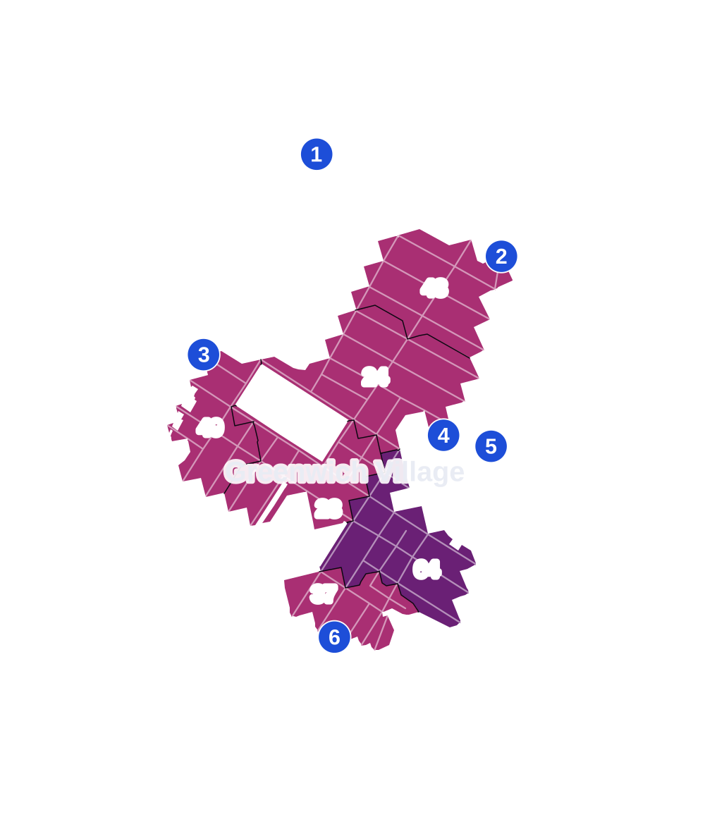
- 5 to 9
- 10 to 19
- 20 to 49
- 50 to 99
- 100 or more
- Not shaded: fewer than 5, held back under the rules in How complaints are counted, parks and public-housing grounds, and land in no patch
- Police precincts
- 6th (most of the area), 9th
From January to June 2026 the NYPD recorded 266 major felonies at places in Greenwich Village, against 310 in the same months of 2025.
Sources: the NYPD's Complaint Data Historic, updated April 28, 2026, and Complaint Data Current (Year To Date), updated July 27, 2026, on NYC Open Data. Figures to June 30, 2026.
Street corners
- 5th Avenue & 8th Street
- 5th Avenue & 9th Street
- 5th Avenue & 10th Street
- 5th Avenue & 11th Street
- 5th Avenue & 12th Street
- 5th Avenue & 13th Street
- 5th Avenue & Washington Mews
- 5th Avenue & Washington Square North
- Avenue of the Americas & Christopher Street
- Avenue of the Americas & Greenwich Avenue
- Avenue of the Americas & West 3rd Street
- Avenue of the Americas & West 10th Street
- Avenue of the Americas & West 11th Street
- Avenue of the Americas & West 12th Street
- Avenue of the Americas & West Houston Street at Bedford Street
- Bleecker Street & Crosby Street
- Bleecker Street & Elizabeth Street
- Bleecker Street & La Guardia Place
- Bleecker Street & MacDougal Street
- Bleecker Street & Mercer Street
- Bleecker Street & Mott Street
- Bleecker Street & Mulberry Street
- Bleecker Street & Sullivan Street
- Bleecker Street & Thompson Street
- Bond Street & Shinbone Alley
- Broadway & 4th Street
- Broadway & Astor Place
- Broadway & Bleecker Street
- Broadway & Bond Street
- Broadway & East 8th Street
- Broadway & East 9th Street
- Broadway & East 10th Street
- Broadway & East 11th Street
- Broadway & East 12th Street
- Broadway & East 13th Street
- Broadway & East 14th Street
- Broadway & Houston Street
- Broadway & Washington Place
- Broadway & Waverly Place
- Broadway & West 3rd Street
- Cooper Square & Astor Place
- East 2nd Street & Bowery
- East 3rd Street & Bowery
- East 4th Street & Bowery
- East 4th Street & Lafayette Street
- East 8th Street & Greene Street
- East 8th Street & University Place
- East 9th Street & 4th Avenue
- East 9th Street & University Place
- East 10th Street & Lafayette Street
- East 10th Street & University Place
- East 11th Street & University Place
- East 12th Street & University Place
- East 13th Street & University Place
- East 14th Street & Union Square East
- East 14th Street & University Place
- East Houston Street & Crosby Street
- East Houston Street & Mott Street
- East Houston Street & Mulberry Street
- Great Jones Street & Shinbone Alley
- Greene Street & Waverly Place
- La Guardia Place & West 3rd Street
- Lafayette Street & Astor Place
- Lafayette Street & Bleecker Street
- Lafayette Street & Bond Street
- Lafayette Street & East 8th Street
- Lafayette Street & Great Jones Street
- Lafayette Street & Jones Alley
- Lafayette Street & Wanamaker Place
- MacDougal Street & MacDougal Alley
- MacDougal Street & Minetta Lane
- MacDougal Street & West 8th Street
- Mercer Street & East 8th Street
- Mercer Street & Waverly Place
- Mercer Street & West 3rd Street
- Minetta Street & Minetta Lane
- Sullivan Street & West 3rd Street
- Thompson Street & Washington Square South
- Thompson Street & West 3rd Street
- Thompson Street & West Houston Street
- Washington Mews & University Place
- Washington Place & Greene Street
- Washington Place & Mercer Street
- Washington Place & Washington Square East
- Washington Place & Washington Square West
- Washington Square South & La Guardia Place
- Washington Square South & Sullivan Street
- Waverly Place & University Place
- Waverly Place & Washington Square North
- West 3rd Street & MacDougal Street
- West 4th Street & Greene Street
- West 4th Street & Mercer Street
- West 4th Street & Washington Square South at MacDougal Street
- West 4th Street & Washington Square South at Washington Square East
- West Houston Street & Greene Street
- West Houston Street & Sullivan Street
- West Houston Street & Wooster Street
How the figures above are measured: Methodology.