Midtown South-Flatiron-Union Square
Neighborhood · Manhattan
Midtown South-Flatiron-Union Square reaches from Union Square at 14th Street past Madison Square to the Empire State Building at 34th Street.
- 0.53 square miles
- 33,214 residents, 2020 Census
- 96 street corners
- 12 subway stations
- 65 bus routes
Union Square, opened as a park in 1839 where Broadway met the old Bowery Road, hosted the first Labor Day parade in 1882 and has held a Greenmarket since 1976. Daniel Burnham's Flatiron Building, completed in 1902 on a narrow triangular lot, gave the surrounding district its name, and the 102-story Empire State Building was finished in 1931. Theodore Roosevelt's re-created birthplace on East 20th Street, a national historic site, honors the 26th president, the first born in New York City.
Sources: Union Square, Manhattan (Wikipedia); Flatiron Building (Encyclopaedia Britannica); Empire State Building (Encyclopaedia Britannica); Theodore Roosevelt Birthplace National Historic Site (National Park Service).
Midtown South-Flatiron-Union Square borders five areas, and 5th Avenue holds more of its corners than any other street, 23 of 96.
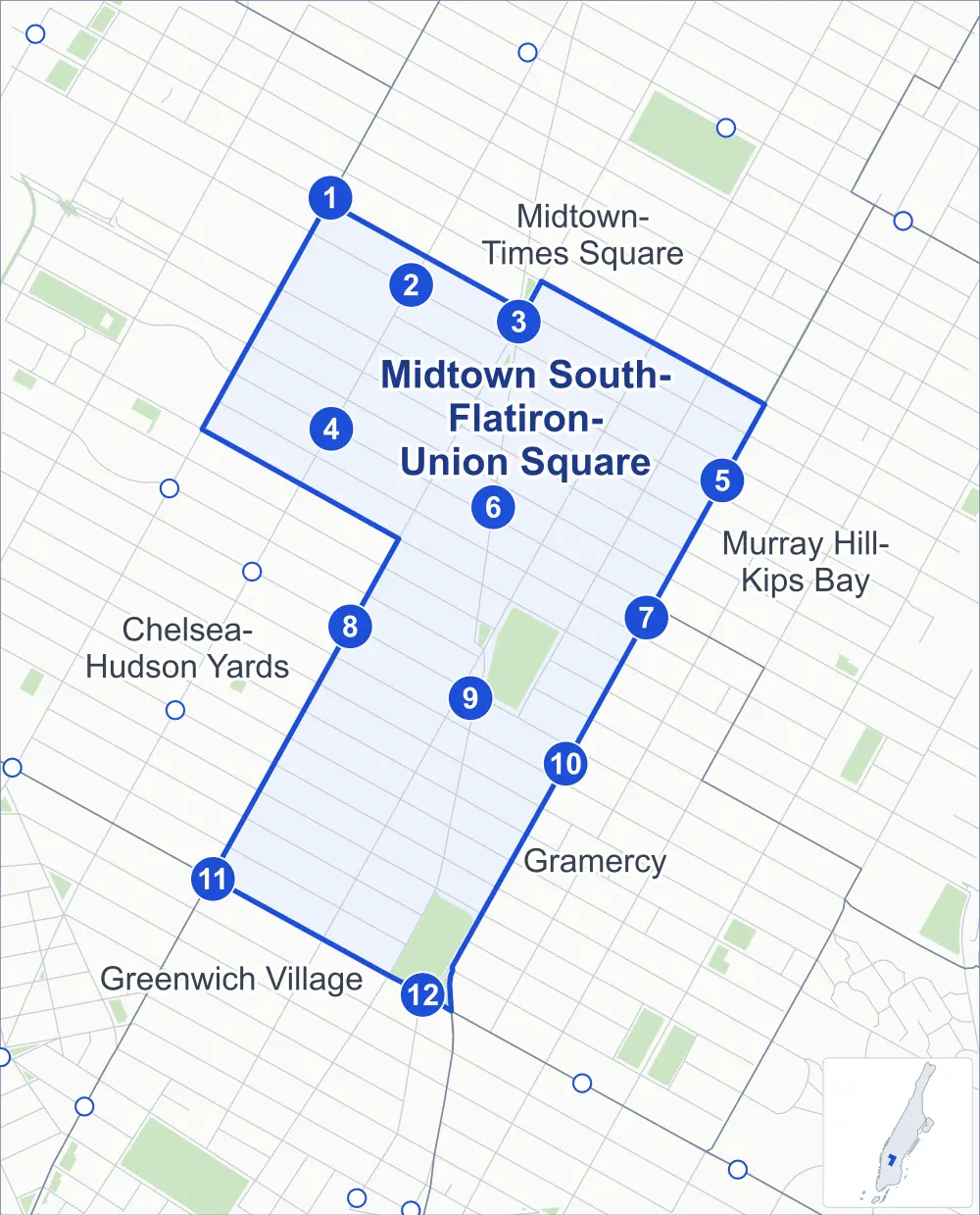
- Midtown South-Flatiron-Union Square
- A neighboring area
- Park
- A station in the list
- Another station
Neighborhood areas and streets: NYC Department of City Planning. Parks: NYC Parks. Stations: MTA.
Neighboring areas
- Midtown-Times Square north
- Murray Hill-Kips Bay east
- Gramercy south
- Greenwich Village south
- Chelsea-Hudson Yards west
Subway stations
- 34 St-Penn Station lines A C E accessible
- 34 St-Penn Station lines 1 2 3 accessible
- 34 St-Herald Sq lines B D F M N Q R W accessible
- 28 St lines 1
- 33 St lines 6
- 28 St lines R W
- 28 St lines 6
- 23 St lines F M
- 23 St lines R W
- 23 St-Baruch College lines 6 accessible
- 14 St / 6 Av lines F L M accessible
- 14 St-Union Sq lines 4 5 6 L N Q R W
Getting around
Twelve subway stations and buses on 65 routes stop in or at the edge of Midtown South-Flatiron-Union Square.
- 12 subway stations
- 5 of them listed by the MTA as fully accessible
- 15 local bus routes
- 50 express bus routes
Local bus routes
- L92
- M1
- M2
- M3
- M4
- M5
- M7
- M14A-SBS
- M14D-SBS
- M20
- M23-SBS
- M34-SBS
- M34A-SBS
- M55
- Q32
Express bus routes
- BM1
- BM2
- BM3
- BM4
- BM5
- BxM2
- BxM3
- BxM4
- BxM6
- BxM7
- BxM8
- BxM9
- BxM10
- BxM11
- BxM18
- QM1
- QM2
- QM4
- QM5
- QM6
- QM10
- QM12
- QM15
- QM16
- QM17
- QM18
- QM20
- QM21
- QM24
- QM63
- QM64
- QM68
- SIM1C
- SIM3
- SIM3C
- SIM4C
- SIM6
- SIM7
- SIM9
- SIM10
- SIM11
- SIM23
- SIM24
- SIM31
- SIM33
- SIM33C
- X27
- X28
- X37
- X38
Safety record
Between 2021 and 2025, its corners averaged more police-reported crashes than the average Manhattan corner.
- 1,629 police-reported crashes at its corners
- 17.0 a corner, on average
- 13.4 the average Manhattan corner
- 1 corner with a clean record
Signal or safety changes on City record, at 63 of its corners
- Leading pedestrian intervals
- 53
- Accessible pedestrian signals
- 21
- Turn calming
- 11
- Barnes Dance all-way crossings
- 6
- Safety Improvement Projects
- 4
Camera tickets
In 2025 its corners had more bus-lane camera tickets than school-zone speed or red-light tickets.
- 0 red-light camera tickets
- 5,053 school-zone speed camera tickets at three corners
- 36,833 bus-lane camera tickets at two corners
- Most speed tickets
- Avenue of the Americas & West 25th Street, 2,630
- Most bus-lane tickets
- 5th Avenue & 14th Street, 29,462
People and homes
The 2020 Census counted 33,214 residents in Midtown South-Flatiron-Union Square, about 62,700 per square mile.
- 19,679 homes, 2020 Census
- 4,412 homes added since April 2010, net, by City Planning's count
Half of its 502 residential lots hold buildings from 1910 or earlier, and 82% of them date from before 1940, by the City's tax lot records.
Parks and landmarks
- Parkland
- 13.2 acres of NYC Parks property
- The largest pieces
- Union Square Park (6.5 acres), Madison Square Park (6.2 acres) and Worth Square (0.3 acre)
- Designated landmarks
- The Aberdeen Hotel, the Empire State Building, 29th Street Towers and the Colony Club, among others
- Historic districts
- Ladies' Mile and Madison Square North, wholly or partly within Midtown South-Flatiron-Union Square
Streets and trees
- Trees
- 1,201 in NYC Parks' records, most often thornless honeylocust, maidenhair tree and Callery pear
- Street with the most corners
- 5th Avenue, with 23 of the area's 96
- Height above sea level
- From 23 feet at 8th Avenue & West 26th Street to 62 feet at 5th Avenue & 35th Street
- Honorary street names
- 3 at its corners, enacted by local law
Schools and libraries
The City lists 14 schools and one library in Midtown South-Flatiron-Union Square.
- Public schools
- 7
- Charter and private schools
- 7
- Library
- Andrew Heiskell Braille and Talking Book Library
Bike share and public art
By the station list of October 3, 2026, 23 bike-share stations stand in Midtown South-Flatiron-Union Square. The City's public art inventory lists 13 works in the area, among them George Washington (1856), General William Jenkins Worth (1857) and Abraham Lincoln (1870).
- 23 bike-share stations
- 13 works of public art
Public safety
How complaints are countedIn 2025 the NYPD recorded 1,284 major felonies at places in Midtown South-Flatiron-Union Square.
Recorded by the NYPD at places in Midtown South-Flatiron-Union Square
- 1,189 major felonies in 2024
- 2,423 other felonies, misdemeanors and violations in 2025
In 2025, on the streets along the edge of Midtown South-Flatiron-Union Square, the NYPD recorded another 1,106 major felonies.
- Police precincts
- 14th, 13th (most of the area), 10th
From January to June 2026 the NYPD recorded 576 major felonies at places in Midtown South-Flatiron-Union Square, against 590 in the same months of 2025.
Sources: the NYPD's Complaint Data Historic, updated April 28, 2026, and Complaint Data Current (Year To Date), updated July 27, 2026, on NYC Open Data. Figures to June 30, 2026.
Street corners
- 5th Avenue & 14th Street
- 5th Avenue & 15th Street
- 5th Avenue & 16th Street
- 5th Avenue & 17th Street
- 5th Avenue & 18th Street
- 5th Avenue & 19th Street
- 5th Avenue & 20th Street
- 5th Avenue & 21st Street
- 5th Avenue & 22nd Street
- 5th Avenue & 23rd Street
- 5th Avenue & 26th Street
- 5th Avenue & 27th Street
- 5th Avenue & 28th Street
- 5th Avenue & 29th Street
- 5th Avenue & 30th Street
- 5th Avenue & 31st Street
- 5th Avenue & 32nd Street
- 5th Avenue & 33rd Street
- 5th Avenue & 34th Street
- 5th Avenue & 35th Street
- 5th Avenue & West 24th Street
- 5th Avenue & West 25th Street
- 7th Avenue & West 26th Street
- 7th Avenue & West 27th Street
- 7th Avenue & West 28th Street
- 7th Avenue & West 29th Street
- 7th Avenue & West 30th Street
- 7th Avenue & West 31st Street
- 7th Avenue & West 32nd Street
- 7th Avenue & West 33rd Street
- 7th Avenue & West 34th Street
- 8th Avenue & West 26th Street
- 8th Avenue & West 28th Street
- 8th Avenue & West 30th Street
- 8th Avenue & West 31st Street
- 8th Avenue & West 33rd Street
- Avenue of the Americas & West 14th Street
- Avenue of the Americas & West 15th Street
- Avenue of the Americas & West 17th Street
- Avenue of the Americas & West 18th Street
- Avenue of the Americas & West 20th Street
- Avenue of the Americas & West 24th Street
- Avenue of the Americas & West 25th Street
- Avenue of the Americas & West 26th Street
- Avenue of the Americas & West 27th Street
- Avenue of the Americas & West 28th Street
- Avenue of the Americas & West 29th Street
- Avenue of the Americas & West 30th Street
- Avenue of the Americas & West 31st Street
- Avenue of the Americas & West 32nd Street
- Avenue of the Americas & West 33rd Street
- Broadway & 5th Avenue
- Broadway & Avenue of the Americas
- Broadway & East 17th Street
- Broadway & East 18th Street
- Broadway & East 19th Street
- Broadway & East 20th Street
- Broadway & East 21st Street
- Broadway & East 22nd Street
- Broadway & East 23rd Street
- Broadway & West 25th Street
- Broadway & West 26th Street
- Broadway & West 27th Street
- Broadway & West 28th Street
- Broadway & West 29th Street
- Broadway & West 30th Street
- Broadway & West 31st Street
- Broadway & West 32nd Street
- Broadway & West 33rd Street
- Broadway & West 34th Street
- East 15th Street & Union Square West
- East 16th Street & Union Square East
- East 16th Street & Union Square West
- East 17th Street & Park Avenue South
- East 19th Street & Park Avenue South
- East 20th Street & Park Avenue South
- East 22nd Street & Park Avenue South
- East 23rd Street & Park Avenue South
- East 25th Street & Park Avenue South
- East 29th Street & Park Avenue South
- Madison Avenue & East 23rd Street
- Madison Avenue & East 24th Street
- Madison Avenue & East 25th Street
- Madison Avenue & East 26th Street
- Madison Avenue & East 27th Street
- Madison Avenue & East 28th Street
- Madison Avenue & East 29th Street
- Madison Avenue & East 30th Street
- Madison Avenue & East 31st Street
- Madison Avenue & East 32nd Street
- Madison Avenue & East 33rd Street
- Madison Avenue & East 34th Street
- Park Avenue & Park Avenue South
- Park Avenue South & East 18th Street
- Park Avenue South & East 24th Street
- Park Avenue South & East 31st Street
How the figures above are measured: Methodology.