Chelsea-Hudson Yards
Neighborhood · Manhattan
Chelsea-Hudson Yards runs up the West Side from 14th Street to about 41st Street, joining Chelsea's historic blocks with Hudson Yards.
- 1.06 square miles
- 69,741 residents, 2020 Census
- 149 street corners
- 8 subway stations
- 27 bus routes
Major Thomas Clarke bought the land in 1750 and named it after London's Royal Hospital Chelsea, and his grandson Clement Clarke Moore gave his apple orchard for the General Theological Seminary in 1827 and split the estate into lots. The High Line, an elevated freight line from the 1930s, reopened as a park in stages from 2009, and art galleries gathered in West Chelsea from the late 1990s. Hudson Yards, named for a rail yard, was rezoned in 2005, and the 7 train reached it in 2015.
Sources: Chelsea, Manhattan (Wikipedia); Hudson Yards, Manhattan (Wikipedia); History (Friends of the High Line).
Chelsea-Hudson Yards borders four areas, and 10th Avenue holds more of its corners than any other street, 27 of 149.
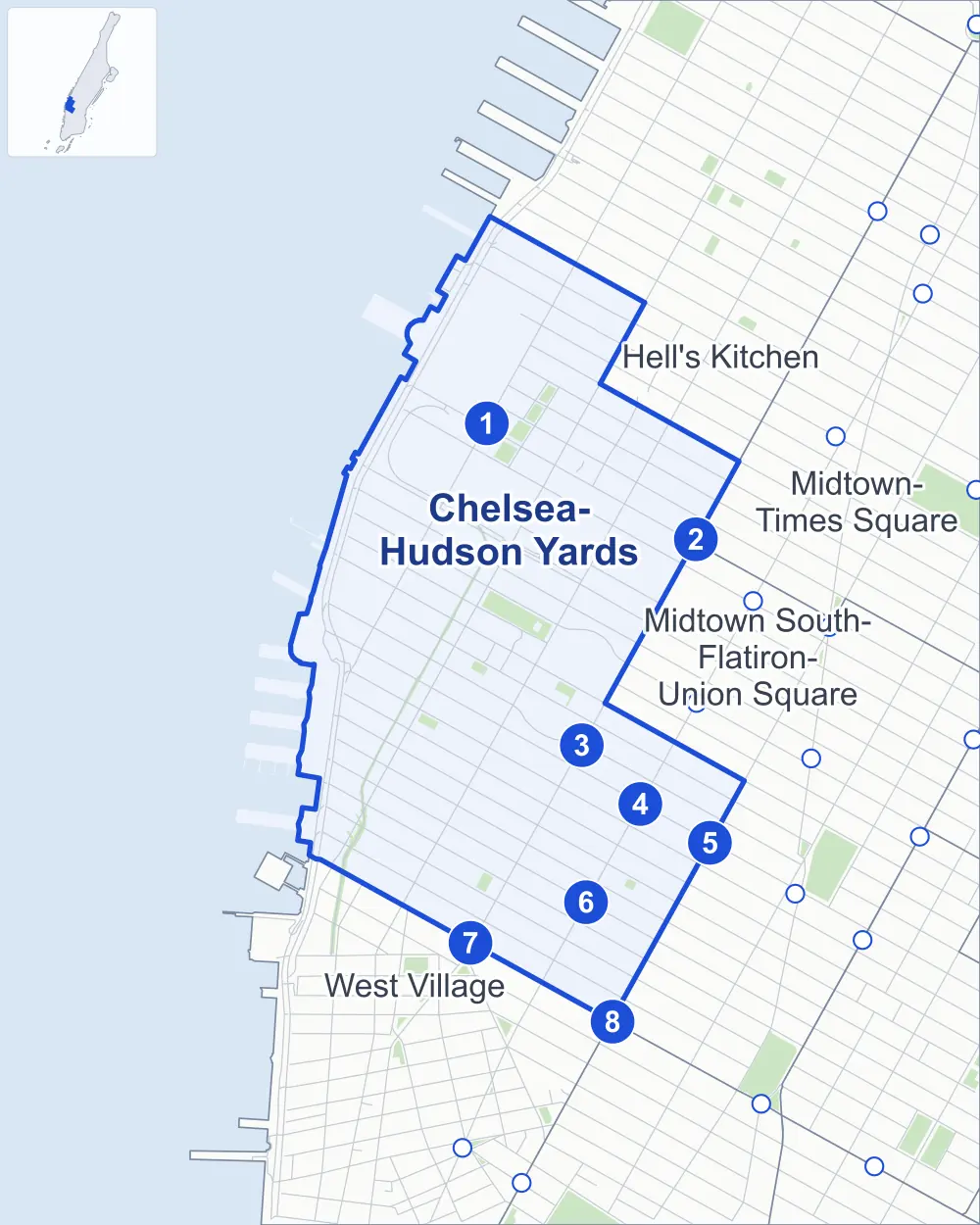
- Chelsea-Hudson Yards
- A neighboring area
- Park
- A station in the list
- Another station
Neighborhood areas and streets: NYC Department of City Planning. Parks: NYC Parks. Stations: MTA.
Neighboring areas
- Hell's Kitchen north
- Midtown-Times Square northeast
- Midtown South-Flatiron-Union Square southeast
- West Village south
Subway stations
- 34 St-Hudson Yards lines 7 accessible
- 34 St-Penn Station lines A C E accessible
- 23 St lines C E
- 23 St lines 1
- 23 St lines F M
- 18 St lines 1
- 14 St / 8 Av lines A C E L accessible
- 14 St / 6 Av lines F L M accessible
Getting around
Eight subway stations and buses on 27 routes stop in or at the edge of Chelsea-Hudson Yards.
- 8 subway stations
- 4 of them listed by the MTA as fully accessible
- 14 local bus routes
- 13 express bus routes
Local bus routes
- L92
- M7
- M11
- M12
- M14A-SBS
- M14D-SBS
- M20
- M23-SBS
- M34-SBS
- M34A-SBS
- M42
- M50
- M55
- T260
Express bus routes
- SIM1C
- SIM3
- SIM3C
- SIM4C
- SIM7
- SIM9
- SIM10
- SIM23
- SIM24
- SIM33
- SIM33C
- X27
- X28
Safety record
Between 2021 and 2025, its corners averaged more police-reported crashes than the average Manhattan corner.
- 2,531 police-reported crashes at its corners
- 17.0 a corner, on average
- 13.4 the average Manhattan corner
- 16 corners with a clean record
Signal or safety changes on City record, at 97 of its corners
- Leading pedestrian intervals
- 84
- Accessible pedestrian signals
- 36
- Turn calming
- 11
- Barnes Dance all-way crossings
- 6
- Safety Improvement Projects
- 3
- Enhanced crossings
- 1
Camera tickets
In 2025 its corners had more school-zone speed camera tickets than bus-lane or red-light tickets.
- 3,899 red-light camera tickets at three corners
- 23,114 school-zone speed camera tickets at seven corners
- 12,951 bus-lane camera tickets at four corners
- Most red-light tickets
- 12th Avenue & West Side Highway at West 42nd Street, 2,139
- Most speed tickets
- 12th Avenue & West Side Highway at West 23rd Street, 14,561
- Most bus-lane tickets
- 7th Avenue & West 14th Street, 9,419
People and homes
The 2020 Census counted 69,741 residents in Chelsea-Hudson Yards, about 65,800 per square mile.
- 43,842 homes, 2020 Census
- 9,852 homes added since April 2010, net, by City Planning's count
Half of its 1,376 residential lots hold buildings from 1910 or earlier, and 84% of them date from before 1940, by the City's tax lot records.
NYCHA developments
NYCHA's Chelsea, Chelsea Addition, Elliott and Fulton developments lie wholly or partly within Chelsea-Hudson Yards.
Parks and landmarks
- Parkland
- 12.2 acres of NYC Parks property
- The largest pieces
- The High Line (4.3 acres), Chelsea Park (3.5 acres) and Bella Abzug Park (2.6 acres)
- Designated landmarks
- The Women's Liberation Center, the Church of the Holy Apostles, the Hotel Chelsea and the New York Public Library's Muhlenberg Branch, among others
- Historic districts
- Chelsea, Chelsea Extension, Lamartine Place and West Chelsea, wholly or partly within Chelsea-Hudson Yards
Streets and trees
- Trees
- 3,568 in NYC Parks' records, most often thornless honeylocust, Callery pear and pin oak
- Street with the most corners
- 10th Avenue, with 27 of the area's 149
- Height above sea level
- From 8 feet at 10th Avenue & West 15th Street to 50 feet at West 34th Street & Dyer Avenue
- Honorary street names
- 8 at its corners, enacted by local law
Schools and libraries
The City lists 19 schools and one library in Chelsea-Hudson Yards.
- Public schools
- 13
- Charter and private schools
- 6
- Library
- Muhlenberg Library
Bike share and public art
By the station list of October 3, 2026, 33 bike-share stations stand in Chelsea-Hudson Yards. The City's public art inventory lists one work in the area: Chelsea Park Memorial (1921).
- 33 bike-share stations
- 1 work of public art
Public safety
How complaints are countedIn 2025 the NYPD recorded 981 major felonies at places in Chelsea-Hudson Yards.
Recorded by the NYPD at places in Chelsea-Hudson Yards
- 991 major felonies in 2024
- 2,902 other felonies, misdemeanors and violations in 2025
In 2025, on the streets along the edge of Chelsea-Hudson Yards, the NYPD recorded another 552 major felonies.
- Police precincts
- 10th (most of the area), 14th, 13th
From January to June 2026 the NYPD recorded 456 major felonies at places in Chelsea-Hudson Yards, against 476 in the same months of 2025.
Sources: the NYPD's Complaint Data Historic, updated April 28, 2026, and Complaint Data Current (Year To Date), updated July 27, 2026, on NYC Open Data. Figures to June 30, 2026.
Street corners
- 7th Avenue & West 14th Street
- 7th Avenue & West 15th Street
- 7th Avenue & West 16th Street
- 7th Avenue & West 17th Street
- 7th Avenue & West 18th Street
- 7th Avenue & West 19th Street
- 7th Avenue & West 20th Street
- 7th Avenue & West 21st Street
- 7th Avenue & West 22nd Street
- 7th Avenue & West 23rd Street
- 7th Avenue & West 24th Street
- 7th Avenue & West 25th Street
- 8th Avenue & West 15th Street
- 8th Avenue & West 16th Street
- 8th Avenue & West 17th Street
- 8th Avenue & West 18th Street
- 8th Avenue & West 19th Street
- 8th Avenue & West 20th Street
- 8th Avenue & West 21st Street
- 8th Avenue & West 22nd Street
- 8th Avenue & West 23rd Street
- 8th Avenue & West 24th Street
- 8th Avenue & West 25th Street
- 8th Avenue & West 27th Street
- 8th Avenue & West 29th Street
- 8th Avenue & West 35th Street
- 8th Avenue & West 36th Street
- 9th Avenue & Lincoln Tunnel (north-east)
- 9th Avenue & Lincoln Tunnel (south-west)
- 9th Avenue & West 14th Street
- 9th Avenue & West 15th Street
- 9th Avenue & West 16th Street
- 9th Avenue & West 17th Street
- 9th Avenue & West 18th Street
- 9th Avenue & West 19th Street
- 9th Avenue & West 20th Street
- 9th Avenue & West 21st Street
- 9th Avenue & West 22nd Street
- 9th Avenue & West 23rd Street
- 9th Avenue & West 24th Street
- 9th Avenue & West 25th Street
- 9th Avenue & West 26th Street
- 9th Avenue & West 27th Drive
- 9th Avenue & West 28th Street
- 9th Avenue & West 29th Street
- 9th Avenue & West 30th Street
- 9th Avenue & West 31st Street
- 9th Avenue & West 33rd Street
- 9th Avenue & West 34th Street
- 9th Avenue & West 35th Street
- 9th Avenue & West 36th Street
- 9th Avenue & West 37th Street
- 10th Avenue & Lincoln Tunnel
- 10th Avenue & Lincoln Tunnel at Path Bus Terminal
- 10th Avenue & Port Authority Bus Terminal
- 10th Avenue & West 15th Street
- 10th Avenue & West 16th Street
- 10th Avenue & West 17th Street
- 10th Avenue & West 18th Street
- 10th Avenue & West 19th Street
- 10th Avenue & West 20th Street
- 10th Avenue & West 21st Street
- 10th Avenue & West 22nd Street
- 10th Avenue & West 23rd Street
- 10th Avenue & West 24th Street
- 10th Avenue & West 25th Street
- 10th Avenue & West 26th Street
- 10th Avenue & West 27th Street
- 10th Avenue & West 28th Street
- 10th Avenue & West 29th Street
- 10th Avenue & West 30th Street
- 10th Avenue & West 31st Street
- 10th Avenue & West 33rd Street
- 10th Avenue & West 34th Street
- 10th Avenue & West 35th Street
- 10th Avenue & West 36th Street
- 10th Avenue & West 37th Street
- 10th Avenue & West 38th Street
- 10th Avenue & West 41st Street
- 11th Avenue & West 23rd Street
- 11th Avenue & West 24th Street
- 11th Avenue & West 25th Street
- 11th Avenue & West 26th Street
- 11th Avenue & West 27th Street
- 11th Avenue & West 28th Street
- 11th Avenue & West 29th Street
- 11th Avenue & West 30th Street
- 11th Avenue & West 33rd Street
- 11th Avenue & West 34th Street
- 11th Avenue & West 35th Street
- 11th Avenue & West 36th Street
- 11th Avenue & West 37th Street
- 11th Avenue & West 38th Street
- 11th Avenue & West 39th Street
- 11th Avenue & West 40th Street
- 11th Avenue & West 41st Street
- 12th Avenue & West Side Highway at Connector
- 12th Avenue & West Side Highway at West 23rd Street
- 12th Avenue & West Side Highway at West 24th Street
- 12th Avenue & West Side Highway at West 26th Street
- 12th Avenue & West Side Highway at West 29th Street
- 12th Avenue & West Side Highway at West 30th Street
- 12th Avenue & West Side Highway at West 34th Street
- 12th Avenue & West Side Highway at West 39th Street
- 12th Avenue & West Side Highway at West 40th Street
- 12th Avenue & West Side Highway at West 41st Street
- 12th Avenue & West Side Highway at West 42nd Street
- Avenue of the Americas & West 16th Street
- Avenue of the Americas & West 19th Street
- Avenue of the Americas & West 21st Street
- Avenue of the Americas & West 22nd Street
- Avenue of the Americas & West 23rd Street
- Dyer Avenue & Lincoln Tunnel (West 35th Street)
- Dyer Avenue & Lincoln Tunnel (West 36th Street)
- Lincoln Tunnel & High Line
- Lincoln Tunnel & Lincoln Tunnel Exit West 39th Street (east)
- Lincoln Tunnel & Lincoln Tunnel Exit West 39th Street (west)
- West 26th Street & West 27th Drive
- West 30th Street & Lincoln Tunnel
- West 31st Street & Dyer Avenue Underpass 31st Street at Lincoln Tunnel (north-west)
- West 31st Street & Dyer Avenue Underpass 31st Street at Lincoln Tunnel (south-east)
- West 33rd Street & Dyer Avenue Underpass 31st Street at Lincoln Tunnel (north-west)
- West 33rd Street & Dyer Avenue Underpass 31st Street at Lincoln Tunnel (south-east)
- West 33rd Street & Hudson Boulevard East
- West 34th Street & Dyer Avenue
- West 34th Street & High Line
- West 34th Street & Hudson Boulevard East
- West 34th Street & Lincoln Tunnel
- West 35th Street & Dyer Avenue
- West 35th Street & Hudson Boulevard East
- West 35th Street & Hudson Boulevard West
- West 35th Street & Lincoln Tunnel
- West 36th Street & Dyer Avenue
- West 36th Street & Dyer Avenue Underpass 31st Street
- West 36th Street & Hudson Boulevard East
- West 36th Street & Hudson Boulevard West
- West 36th Street & Lincoln Tunnel
- West 37th Street & Hudson Boulevard East
- West 37th Street & Hudson Boulevard West
- West 39th Street & Lincoln Tunnel
- West 39th Street & Lincoln Tunnel Exit West 39th Street
- West 40th Street & Galvin Avenue
- West 40th Street & Lincoln Tunnel
- West 40th Street & Path Bus Terminal
- West 41st Street & Galvin Avenue
- West Side Highway & 11th Avenue at West 15th Street
- West Side Highway & 11th Avenue at West 16th Street
- West Side Highway & 11th Avenue at West 17th Street
- West Side Highway & 11th Avenue at West 18th Street
How the figures above are measured: Methodology.