Midtown-Times Square
Neighborhood · Manhattan
From Herald Square at 34th Street north to 59th Street, Midtown-Times Square covers the heart of Midtown Manhattan, taking in the Garment District and the Diamond District on West 47th Street.
- 0.88 square miles
- 25,575 residents, 2020 Census
- 162 street corners
- 14 subway stations
- 71 bus routes
Times Square, once known as Longacre Square, sits where Broadway meets Seventh Avenue and 42nd Street and is the center of the city's Theater District. Rockefeller Center, a complex of commercial and entertainment buildings, includes Radio City Music Hall and a plaza that holds a skating rink and a Christmas tree in winter. The New York Public Library's Beaux-Arts flagship on Fifth Avenue at 42nd Street dates from 1911.
Sources: Midtown Manhattan (Wikipedia); Times Square (Encyclopaedia Britannica); Rockefeller Center (Encyclopaedia Britannica); Stephen A. Schwarzman Building (New York Public Library).
Midtown-Times Square borders eight areas, and Avenue of the Americas holds more of its corners than any other street, 26 of 162.
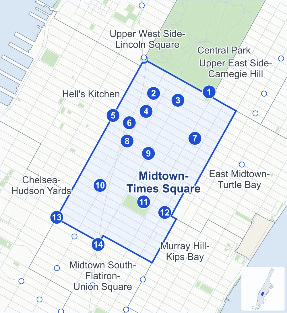
- Midtown-Times Square
- A neighboring area
- Park
- A station in the list
- Another station
Neighborhood areas and streets: NYC Department of City Planning. Parks: NYC Parks. Stations: MTA.
Neighboring areas
- Central Park north
- Upper West Side-Lincoln Square north
- Upper East Side-Carnegie Hill northeast
- East Midtown-Turtle Bay east
- Murray Hill-Kips Bay south
- Midtown South-Flatiron-Union Square southwest
- Chelsea-Hudson Yards southwest
- Hell's Kitchen northwest
Subway stations
- 5 Av/59 St lines N R W
- 57 St-7 Av lines N Q R W accessible
- 57 St lines M accessible
- 7 Av lines B D E
- 50 St lines C E
- 50 St lines 1
- 5 Av/53 St lines E F
- 49 St lines N R W
- 47-50 Sts-Rockefeller Ctr lines B D F M accessible
- 42 St-Port Authority Bus Terminal / Times Sq-42 St lines 1 2 3 7 A C E N Q R S W accessible
- 42 St-Bryant Pk / 5 Av lines 7 B D F M
- Grand Central-42 St lines S accessible
- 34 St-Penn Station lines A C E accessible
- 34 St-Herald Sq lines B D F M N Q R W accessible
Getting around
Fourteen subway stations and buses on 71 routes stop in or at the edge of Midtown-Times Square.
- 14 subway stations
- 7 of them listed by the MTA as fully accessible
- 19 local bus routes
- 52 express bus routes
Local bus routes
- M1
- M2
- M3
- M4
- M5
- M7
- M10
- M12
- M20
- M31
- M34-SBS
- M34A-SBS
- M42
- M50
- M55
- M57
- M104
- Q32
- T260
Express bus routes
- BM1
- BM2
- BM3
- BM4
- BM5
- BxM2
- BxM3
- BxM4
- BxM6
- BxM7
- BxM8
- BxM9
- BxM10
- BxM11
- BxM18
- QM1
- QM2
- QM4
- QM5
- QM6
- QM10
- QM12
- QM15
- QM16
- QM17
- QM18
- QM20
- QM21
- QM24
- QM63
- QM64
- QM68
- SIM1C
- SIM3
- SIM3C
- SIM4C
- SIM6
- SIM8
- SIM10
- SIM11
- SIM22
- SIM23
- SIM24
- SIM25
- SIM26
- SIM30
- SIM31
- SIM33C
- X27
- X28
- X37
- X38
Safety record
Between 2021 and 2025, its corners averaged more police-reported crashes than the average Manhattan corner.
- 3,046 police-reported crashes at its corners
- 18.8 a corner, on average
- 13.4 the average Manhattan corner
Signal or safety changes on City record, at 97 of its corners
- Leading pedestrian intervals
- 85
- Accessible pedestrian signals
- 26
- Turn calming
- 11
- Barnes Dance all-way crossings
- 3
- Safety Improvement Projects
- 3
Camera tickets
In 2025 its corners had more bus-lane camera tickets than red-light or school-zone speed tickets.
- 0 red-light camera tickets
- 0 school-zone speed camera tickets
- 18,728 bus-lane camera tickets at four corners
- Most bus-lane tickets
- Madison Avenue & East 50th Street, 8,043
People and homes
The 2020 Census counted 25,575 residents in Midtown-Times Square, about 29,100 per square mile.
- 19,914 homes, 2020 Census
- 1,736 homes added since April 2010, net, by City Planning's count
Half of its 308 residential lots hold buildings from 1923 or earlier, and 72% of them date from before 1940, by the City's tax lot records.
Parks and landmarks
- Parkland
- 9.6 acres of Bryant Park, as NYC Parks maps it within Midtown-Times Square
- Designated landmarks
- The Fashion Tower, the Mecca Temple, the Springs Mills Building and the Brill Building, among others
Streets and trees
- Trees
- 1,304 in NYC Parks' records, most often thornless honeylocust, maidenhair tree and London planetree
- Street with the most corners
- Avenue of the Americas, with 26 of the area's 162
- Height above sea level
- From 32 feet at 8th Avenue & West 37th Street to 84 feet at 7th Avenue & West 58th Street
- Honorary street names
- 12 at its corners, enacted by local law
Schools and libraries
The City lists three schools and three libraries in Midtown-Times Square.
- Public schools
- 2
- Charter or private school
- 1
- Libraries
- 53rd Street Library, Stavros Niarchos Foundation Library (SNFL) and Stephen A. Schwarzman Building
Bike share and public art
By the station list of October 3, 2026, 38 bike-share stations stand in Midtown-Times Square. The City's public art inventory lists 14 works in the area, among them William Earl Dodge (1885), James Gordon Bennett Memorial (1895) and William Cullen Bryant (1911).
- 38 bike-share stations
- 14 works of public art
Public safety
How complaints are countedIn 2025 the NYPD recorded 2,455 major felonies at places in Midtown-Times Square.
Recorded by the NYPD at places in Midtown-Times Square
- 2,688 major felonies in 2024 233 fewer in 2025
- 6,581 other felonies, misdemeanors and violations in 2025
In 2025, on the streets along the edge of Midtown-Times Square, the NYPD recorded another 821 major felonies.
- Police precincts
- 18th (most of the area), 14th, 17th
From January to June 2026 the NYPD recorded 1,144 major felonies at places in Midtown-Times Square, against 1,201 in the same months of 2025.
Sources: the NYPD's Complaint Data Historic, updated April 28, 2026, and Complaint Data Current (Year To Date), updated July 27, 2026, on NYC Open Data. Figures to June 30, 2026.
Street corners
- 5th Avenue & 36th Street
- 5th Avenue & 37th Street
- 5th Avenue & 38th Street
- 5th Avenue & 39th Street
- 5th Avenue & 40th Street
- 5th Avenue & 42nd Street
- 5th Avenue & 43rd Street
- 5th Avenue & 44th Street
- 5th Avenue & 45th Street
- 5th Avenue & 46th Street
- 5th Avenue & 47th Street
- 5th Avenue & 48th Street
- 5th Avenue & 49th Street
- 5th Avenue & 50th Street
- 5th Avenue & 51st Street
- 5th Avenue & 52nd Street
- 5th Avenue & 53rd Street
- 5th Avenue & 54th Street
- 5th Avenue & 55th Street
- 5th Avenue & 56th Street
- 5th Avenue & 57th Street
- 5th Avenue & 58th Street
- 5th Avenue & East 41st Street
- 5th Avenue & East 59th Street
- 7th Avenue & Central Park South
- 7th Avenue & West 35th Street
- 7th Avenue & West 36th Street
- 7th Avenue & West 37th Street
- 7th Avenue & West 38th Street
- 7th Avenue & West 39th Street
- 7th Avenue & West 40th Street
- 7th Avenue & West 41st Street
- 7th Avenue & West 42nd Street
- 7th Avenue & West 43rd Street
- 7th Avenue & West 44th Street
- 7th Avenue & West 46th Street
- 7th Avenue & West 47th Street
- 7th Avenue & West 48th Street
- 7th Avenue & West 49th Street
- 7th Avenue & West 50th Street
- 7th Avenue & West 51st Street
- 7th Avenue & West 52nd Street
- 7th Avenue & West 53rd Street
- 7th Avenue & West 54th Street
- 7th Avenue & West 55th Street
- 7th Avenue & West 56th Street
- 7th Avenue & West 57th Street
- 7th Avenue & West 58th Street
- 8th Avenue & West 34th Street
- 8th Avenue & West 37th Street
- 8th Avenue & West 46th Street
- 8th Avenue & West 47th Street
- 8th Avenue & West 48th Street
- 8th Avenue & West 49th Street
- 8th Avenue & West 54th Street
- 8th Avenue & West 56th Street
- 8th Avenue & West 57th Street
- Avenue of the Americas & Center Drive
- Avenue of the Americas & West 34th Street
- Avenue of the Americas & West 35th Street
- Avenue of the Americas & West 36th Street
- Avenue of the Americas & West 37th Street
- Avenue of the Americas & West 38th Street
- Avenue of the Americas & West 39th Street
- Avenue of the Americas & West 40th Street
- Avenue of the Americas & West 41st Street
- Avenue of the Americas & West 42nd Street
- Avenue of the Americas & West 43rd Street
- Avenue of the Americas & West 44th Street
- Avenue of the Americas & West 45th Street
- Avenue of the Americas & West 46th Street
- Avenue of the Americas & West 47th Street
- Avenue of the Americas & West 48th Street
- Avenue of the Americas & West 49th Street
- Avenue of the Americas & West 50th Street
- Avenue of the Americas & West 51st Street
- Avenue of the Americas & West 52nd Street
- Avenue of the Americas & West 53rd Street
- Avenue of the Americas & West 54th Street
- Avenue of the Americas & West 55th Street
- Avenue of the Americas & West 56th Street
- Avenue of the Americas & West 57th Street
- Avenue of the Americas & West 58th Street
- Broadway & 7th Avenue
- Broadway & West 35th Street
- Broadway & West 36th Street
- Broadway & West 37th Street
- Broadway & West 38th Street
- Broadway & West 39th Street
- Broadway & West 40th Street
- Broadway & West 41st Street
- Broadway & West 42nd Street
- Broadway & West 43rd Street
- Broadway & West 44th Street
- Broadway & West 46th Street
- Broadway & West 47th Street
- Broadway & West 48th Street
- Broadway & West 49th Street
- Broadway & West 50th Street
- Broadway & West 51st Street
- Broadway & West 52nd Street
- Broadway & West 53rd Street
- Broadway & West 54th Street
- Broadway & West 55th Street
- Broadway & West 56th Street
- Broadway & West 57th Street
- Broadway & West 58th Street
- Central Park South & Columbus Circle
- Central Park South & Grand Army Plaza
- East 43rd Street & Vanderbilt Avenue
- East 44th Street & Vanderbilt Avenue
- East 46th Street & Vanderbilt Avenue
- East 47th Street & Vanderbilt Avenue
- Madison Avenue & East 35th Street
- Madison Avenue & East 36th Street
- Madison Avenue & East 37th Street
- Madison Avenue & East 38th Street
- Madison Avenue & East 39th Street
- Madison Avenue & East 40th Street
- Madison Avenue & East 41st Street
- Madison Avenue & East 42nd Street
- Madison Avenue & East 43rd Street
- Madison Avenue & East 44th Street
- Madison Avenue & East 45th Street
- Madison Avenue & East 46th Street
- Madison Avenue & East 47th Street
- Madison Avenue & East 48th Street
- Madison Avenue & East 49th Street
- Madison Avenue & East 50th Street
- Madison Avenue & East 51st Street
- Madison Avenue & East 52nd Street
- Madison Avenue & East 53rd Street
- Madison Avenue & East 54th Street
- Madison Avenue & East 55th Street
- Madison Avenue & East 56th Street
- Madison Avenue & East 57th Street
- Madison Avenue & East 58th Street
- Park Avenue & East 38th Street
- Park Avenue & East 39th Street
- Park Avenue & East 40th Street
- Park Avenue & East 41st Street
- Park Avenue & East 47th Street
- Park Avenue & East 48th Street
- Park Avenue & East 50th Street
- Park Avenue & East 51st Street
- Park Avenue & East 52nd Street
- Park Avenue & East 53rd Street
- Park Avenue & East 57th Street
- West 44th Street & Shubert Alley
- West 45th Street & Shubert Alley
- West 48th Street & Rockefeller Plaza
- West 49th Street & Rockefeller Plaza
- West 50th Street & Rockefeller Plaza
- West 51st Street & 6½ Avenue
- West 51st Street & Rockefeller Plaza
- West 52nd Street & 6½ Avenue
- West 53rd Street & 6½ Avenue
- West 54th Street & 6½ Avenue
- West 55th Street & 6½ Avenue
- West 56th Street & 6½ Avenue
- West 57th Street & 6½ Avenue
- West 58th Street & Grand Army Plaza
How the figures above are measured: Methodology.