Upper West Side-Lincoln Square
Neighborhood · Manhattan
Upper West Side-Lincoln Square covers the Upper West Side from roughly 59th Street to 72nd Street, bordered by Hell's Kitchen and Central Park.
- 0.57 square miles
- 70,697 residents, 2020 Census
- 107 street corners
- 4 subway stations
- 11 bus routes
The city's Board of Aldermen made the name Lincoln Square official in 1906, though its records give no reason for the choice. The area is anchored by Lincoln Center for the Performing Arts, built mainly in the 1960s by a board of architects under Wallace K. Harrison; its buildings, set around a fountain plaza, house the Metropolitan Opera, the New York Philharmonic, New York City Ballet and the Juilliard School. Fordham University's Manhattan campus is also here.
Sources: Lincoln Square, Manhattan (Wikipedia); Lincoln Center for the Performing Arts (Encyclopaedia Britannica).
Upper West Side-Lincoln Square borders four areas, and Broadway holds more of its corners than any other street, 18 of 107.
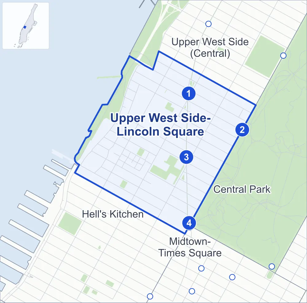
- Upper West Side-Lincoln Square
- A neighboring area
- Park
- A station in the list
- Another station
Neighborhood areas and streets: NYC Department of City Planning. Parks: NYC Parks. Stations: MTA.
Neighboring areas
- Upper West Side (Central) north
- Central Park southeast
- Midtown-Times Square south
- Hell's Kitchen southwest
Subway stations
- 72 St lines 1 2 3 accessible
- 72 St lines B C
- 66 St-Lincoln Center lines 1 accessible
- 59 St-Columbus Circle lines 1 A B C D accessible
Getting around
Four subway stations and buses on 11 routes stop in or at the edge of Upper West Side-Lincoln Square.
- 4 subway stations
- 3 of them listed by the MTA as fully accessible
- 10 local bus routes
- 1 express bus route
Local bus routes
- M5
- M7
- M10
- M11
- M12
- M20
- M57
- M66
- M72
- M104
Express bus route
- BxM2
Safety record
Between 2021 and 2025, its corners averaged fewer police-reported crashes than the average Manhattan corner.
- 1,285 police-reported crashes at its corners
- 12.0 a corner, on average
- 13.4 the average Manhattan corner
- 8 corners with a clean record
Signal or safety changes on City record, at 78 of its corners
- Leading pedestrian intervals
- 52
- Accessible pedestrian signals
- 39
- Barnes Dance all-way crossings
- 12
- Turn calming
- 6
- Safety Improvement Projects
- 5
- Enhanced crossings
- 3
Camera tickets
In 2025 its corners had more school-zone speed camera tickets than red-light or bus-lane tickets.
- 3,958 red-light camera tickets at one corner
- 16,650 school-zone speed camera tickets at ten corners
- 0 bus-lane camera tickets
- Most red-light tickets
- West End Avenue & West 66th Street, 3,958
- Most speed tickets
- West End Avenue & West 70th Street, 3,209
People and homes
The 2020 Census counted 70,697 residents in Upper West Side-Lincoln Square, about 124,000 per square mile.
- 44,545 homes, 2020 Census
- 4,040 homes added since April 2010, net, by City Planning's count
Half of its 790 residential lots hold buildings from 1894 or earlier, and 86% of them date from before 1940, by the City's tax lot records.
NYCHA developments
NYCHA's Amsterdam and Amsterdam Addition developments lie wholly or partly within Upper West Side-Lincoln Square.
Parks and landmarks
- Parkland
- 30.8 acres of NYC Parks property
- The largest pieces
- Riverside Park South (21.1 acres), Lincoln Center Plaza (4.1 acres) and Damrosch Park (2.4 acres)
- Designated landmarks
- The First Battery Armory, the Sofia Brothers Warehouse, the Church of Saint Paul the Apostle and the Ansonia Hotel, among others
- Historic districts
- Central Park West - West 73rd - 74th Street, Upper West Side/Central Park West and West 71st Street, wholly or partly within Upper West Side-Lincoln Square
Streets and trees
- Trees
- 2,592 in NYC Parks' records, most often thornless honeylocust, London planetree and Callery pear
- Street with the most corners
- Broadway, with 18 of the area's 107
- Height above sea level
- From 7 feet at West 59th Street & Riverside Boulevard to 90 feet at Central Park West & West 70th Street
- Honorary street names
- 8 at its corners, enacted by local law
Schools and libraries
The City lists 25 schools and two libraries in Upper West Side-Lincoln Square.
- Public schools
- 11
- Charter and private schools
- 14
- Libraries
- Riverside Library and The New York Public Library for the Performing Arts
Bike share and public art
By the station list of October 3, 2026, 14 bike-share stations stand in Upper West Side-Lincoln Square. The City's public art inventory lists seven works in the area, among them Columbus Monument (1892), Giuseppe Verdi (1906) and Dante Alighieri (1921).
- 14 bike-share stations
- 7 works of public art
Public safety
How complaints are countedIn 2025 the NYPD recorded 728 major felonies at places in Upper West Side-Lincoln Square.
Recorded by the NYPD at places in Upper West Side-Lincoln Square
- 801 major felonies in 2024
- 2,079 other felonies, misdemeanors and violations in 2025
In 2025, on the streets along the edge of Upper West Side-Lincoln Square, the NYPD recorded another 77 major felonies. Counting the streets along its edge, in 2025 the NYPD recorded 11.4 major felonies for every thousand residents the 2020 Census counted in Upper West Side-Lincoln Square.
- Police precincts
- 20th (most of the area), 18th
From January to June 2026 the NYPD recorded 361 major felonies at places in Upper West Side-Lincoln Square, against 345 in the same months of 2025.
Sources: the NYPD's Complaint Data Historic, updated April 28, 2026, and Complaint Data Current (Year To Date), updated July 27, 2026, on NYC Open Data. Figures to June 30, 2026.
Street corners
- 8th Avenue & Columbus Circle
- 9th Avenue & Columbus Avenue
- 9th Avenue & West 58th Street
- 10th Avenue & West 58th Street
- 11th Avenue & West 58th Street
- 11th Avenue & West End Avenue
- Amsterdam Avenue & 10th Avenue
- Amsterdam Avenue & West 60th Street
- Amsterdam Avenue & West 61st Street
- Amsterdam Avenue & West 62nd Street
- Amsterdam Avenue & West 64th Street
- Amsterdam Avenue & West 65th Street
- Amsterdam Avenue & West 66th Street
- Amsterdam Avenue & West 67th Street
- Amsterdam Avenue & West 68th Street
- Amsterdam Avenue & West 69th Street
- Amsterdam Avenue & West 70th Street
- Amsterdam Avenue & West 72nd Street
- Amsterdam Avenue & West 73rd Street
- Amsterdam Avenue & West 74th Street
- Broadway & Amsterdam Avenue
- Broadway & Amsterdam Avenue at West 71st Street
- Broadway & Columbus Avenue
- Broadway & Columbus Circle
- Broadway & West 60th Street
- Broadway & West 61st Street
- Broadway & West 62nd Street
- Broadway & West 63rd Street
- Broadway & West 64th Street
- Broadway & West 65th Street
- Broadway & West 66th Street
- Broadway & West 67th Street
- Broadway & West 68th Street
- Broadway & West 69th Street
- Broadway & West 70th Street
- Broadway & West 72nd Street
- Broadway & West 73rd Street
- Broadway & West 74th Street
- Central Park West & 65th Street Transverse
- Central Park West & Columbus Circle
- Central Park West & West 61st Street
- Central Park West & West 62nd Street
- Central Park West & West 63rd Street
- Central Park West & West 64th Street
- Central Park West & West 65th Street
- Central Park West & West 67th Street
- Central Park West & West 68th Street
- Central Park West & West 69th Street
- Central Park West & West 70th Street
- Central Park West & West 71st Street
- Central Park West & West 72nd Street
- Central Park West & West 73rd Street
- Columbus Avenue & West 60th Street
- Columbus Avenue & West 61st Street
- Columbus Avenue & West 62nd Street
- Columbus Avenue & West 63rd Street
- Columbus Avenue & West 64th Street
- Columbus Avenue & West 65th Street
- Columbus Avenue & West 66th Street
- Columbus Avenue & West 67th Street
- Columbus Avenue & West 68th Street
- Columbus Avenue & West 69th Street
- Columbus Avenue & West 70th Street
- Columbus Avenue & West 71st Street
- Columbus Avenue & West 72nd Street
- Columbus Avenue & West 73rd Street
- Columbus Avenue & West 74th Street
- Columbus Circle & Central Park Entrance 8th Avenue
- Henry Hudson Parkway & 12th Avenue
- Riverside Boulevard & West 61st Street
- Riverside Boulevard & West 63rd Street
- Riverside Boulevard & West 64th Street
- Riverside Boulevard & West 66th Street
- Riverside Boulevard & West 67th Street
- Riverside Boulevard & West 68th Street
- Riverside Boulevard & West 69th Street
- Riverside Boulevard & West 71st Street
- Riverside Boulevard & West 72nd Street
- Riverside Drive & West 72nd Street
- Riverside Drive & West 73rd Street
- West 59th Street & Freedom Place South
- West 59th Street & Riverside Boulevard
- West 60th Street & Freedom Place South
- West 61st Street & Freedom Place South
- West 62nd Street & Freedom Place South
- West 62nd Street & Riverside Boulevard
- West 63rd Street & Freedom Place South
- West 64th Street & Freedom Place South
- West 65th Street & Riverside Boulevard
- West 66th Street & Freedom Place
- West 68th Street & Freedom Place
- West 69th Street & Freedom Place
- West 70th Street & Freedom Place
- West 70th Street & Riverside Boulevard
- West End Avenue & West 60th Street
- West End Avenue & West 61st Drive
- West End Avenue & West 61st Street
- West End Avenue & West 62nd Street
- West End Avenue & West 63rd Street
- West End Avenue & West 64th Street
- West End Avenue & West 65th Street
- West End Avenue & West 66th Street
- West End Avenue & West 70th Street
- West End Avenue & West 71st Street
- West End Avenue & West 72nd Street
- West End Avenue & West 73rd Street
- West End Avenue & West 74th Street
How the figures above are measured: Methodology.