Upper West Side (Central)
Neighborhood · Manhattan
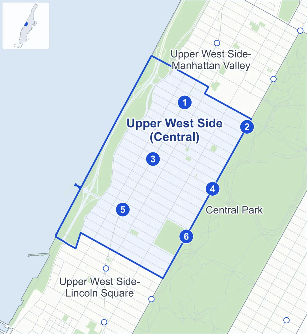
Between Central Park and the Hudson River, Upper West Side (Central) takes in the middle of the Upper West Side, with Riverside Park and Riverside Drive, both laid out to Frederick Law Olmsted's designs.
- 0.91 square miles
- 101,767 residents, 2020 Census
- 145 street corners
- 6 subway stations
- 10 bus routes
Once called Bloomingdale, probably after the Dutch town of Bloemendaal, it saw a building boom from 1885 to 1910 after the Ninth Avenue elevated line arrived in the 1870s and the city's first subway opened in 1904. The American Museum of Natural History, founded in 1869 and home to the Hayden Planetarium, and the New-York Historical Society are among its institutions. The Soldiers' and Sailors' Monument stands at Riverside Drive and 89th Street.
Sources: Upper West Side (Wikipedia); American Museum of Natural History (Encyclopaedia Britannica).
Upper West Side (Central) borders three areas.
- Upper West Side (Central)
- A neighboring area
- Park
- A station in the list
- Another station
Neighborhood areas and streets: NYC Department of City Planning. Parks: NYC Parks. Stations: MTA.
Neighboring areas
- Upper West Side-Manhattan Valley northeast
- Central Park southeast
- Upper West Side-Lincoln Square southwest
Subway stations
- 96 St lines 1 2 3 accessible
- 96 St lines B C
- 86 St lines 1
- 86 St lines B C
- 79 St lines 1
- 81 St-Museum of Natural History lines B C
Getting around
Six subway stations and buses on ten routes stop in or at the edge of Upper West Side (Central).
- 6 subway stations
- 1 of them listed by the MTA as fully accessible
- 9 local bus routes
- 1 express bus route
Local bus routes
- M5
- M7
- M10
- M11
- M79-SBS
- M86-SBS
- M96
- M104
- M106
Express bus route
- BxM2
Safety record
Between 2021 and 2025, its corners averaged more police-reported crashes than the average Manhattan corner.
- 2,043 police-reported crashes at its corners
- 14.1 a corner, on average
- 13.4 the average Manhattan corner
- 4 corners with a clean record
Signal or safety changes on City record, at 125 of its corners
- Leading pedestrian intervals
- 105
- Accessible pedestrian signals
- 39
- Barnes Dance all-way crossings
- 17
- Turn calming
- 11
- Enhanced crossings
- 2
- Safety Improvement Projects
- 2
Camera tickets
In 2025 its corners had more school-zone speed camera tickets than red-light or bus-lane tickets.
- 351 red-light camera tickets at one corner
- 7,726 school-zone speed camera tickets at seven corners
- 315 bus-lane camera tickets at one corner
- Most red-light tickets
- Amsterdam Avenue & West 96th Street, 351
- Most speed tickets
- Amsterdam Avenue & West 96th Street, 2,550
- Most bus-lane tickets
- Central Park West & West 86th Street, 315
People and homes
The 2020 Census counted 101,767 residents in Upper West Side (Central), about 111,800 per square mile.
- 56,787 homes, 2020 Census
- 64 homes added since April 2010, net, by City Planning's count
Half of its 2,404 residential lots hold buildings from 1894 or earlier, and 95% of them date from before 1940, by the City's tax lot records.
NYCHA developments
NYCHA's De Hostos Apartments, Rehab Program (Wise Rehab), Thomas Apartments and WSUR (Brownstones) developments lie wholly or partly within Upper West Side (Central), as do four more that NYCHA names by buildings' addresses.
Parks and landmarks
- Parkland
- 84.9 acres of Riverside Park, as NYC Parks maps it within Upper West Side (Central)
- Designated landmarks
- The Belleclaire Hotel, the Trinity School, the (former) St. Agnes Parish House and the Belnord Apartments, among others
- Historic districts
- Central Park West - 76th Street, Riverside Drive-West 80th-81st Street, Riverside-West End, Riverside-West End Extension I, Upper West Side/Central Park West and West End - Collegiate, wholly or partly within Upper West Side (Central)
Streets and trees
- Trees
- 6,671 in NYC Parks' records, most often thornless honeylocust, pin oak and London planetree
- Street with the most corners
- Amsterdam Avenue, with 24 of the area's 145
- Height above sea level
- From 37 feet at Riverside Drive & West 97th Street to 121 feet at Columbus Avenue & West 93rd Street
- Honorary street names
- 15 at its corners, enacted by local law
Schools and libraries
The City lists 41 schools and one library in Upper West Side (Central).
- Public schools
- 17
- Charter and private schools
- 24
- Library
- St. Agnes Library
Bike share and public art
By the station list of October 3, 2026, 20 bike-share stations stand in Upper West Side (Central). The City's public art inventory lists four works in the area, among them Soldiers and Sailors Monument (1902), Robert Ray Hamilton Fountain (1906) and The New York Times Capsule (2000).
- 20 bike-share stations
- 4 works of public art
Public safety
How complaints are countedIn 2025 the NYPD recorded 878 major felonies at places in Upper West Side (Central).
Recorded by the NYPD at places in Upper West Side (Central)
- 866 major felonies in 2024
- 2,837 other felonies, misdemeanors and violations in 2025
In 2025, on the streets along the edge of Upper West Side (Central), the NYPD recorded another 83 major felonies. Counting the streets along its edge, in 2025 the NYPD recorded 9.4 major felonies for every thousand residents the 2020 Census counted in Upper West Side (Central).
- Police precincts
- 24th, 20th (most of the area)
From January to June 2026 the NYPD recorded 465 major felonies at places in Upper West Side (Central), against 416 in the same months of 2025.
Sources: the NYPD's Complaint Data Historic, updated April 28, 2026, and Complaint Data Current (Year To Date), updated July 27, 2026, on NYC Open Data. Figures to June 30, 2026.
Street corners
- Amsterdam Avenue & West 75th Street
- Amsterdam Avenue & West 76th Street
- Amsterdam Avenue & West 77th Street
- Amsterdam Avenue & West 78th Street
- Amsterdam Avenue & West 79th Street
- Amsterdam Avenue & West 80th Street
- Amsterdam Avenue & West 81st Street
- Amsterdam Avenue & West 82nd Street
- Amsterdam Avenue & West 83rd Street
- Amsterdam Avenue & West 84th Street
- Amsterdam Avenue & West 85th Street
- Amsterdam Avenue & West 86th Street
- Amsterdam Avenue & West 87th Street
- Amsterdam Avenue & West 88th Street
- Amsterdam Avenue & West 89th Street
- Amsterdam Avenue & West 90th Street
- Amsterdam Avenue & West 91st Street
- Amsterdam Avenue & West 92nd Street
- Amsterdam Avenue & West 93rd Street
- Amsterdam Avenue & West 94th Street
- Amsterdam Avenue & West 95th Street
- Amsterdam Avenue & West 96th Street
- Amsterdam Avenue & West 97th Street
- Amsterdam Avenue & West 98th Street
- Broadway & West 75th Street
- Broadway & West 76th Street
- Broadway & West 77th Street
- Broadway & West 78th Street
- Broadway & West 79th Street
- Broadway & West 80th Street
- Broadway & West 81st Street
- Broadway & West 82nd Street
- Broadway & West 83rd Street
- Broadway & West 84th Street
- Broadway & West 85th Street
- Broadway & West 86th Street
- Broadway & West 87th Street
- Broadway & West 88th Street
- Broadway & West 89th Street
- Broadway & West 90th Street
- Broadway & West 91st Street
- Broadway & West 92nd Street
- Broadway & West 93rd Street
- Broadway & West 94th Street
- Broadway & West 95th Street
- Broadway & West 96th Street
- Broadway & West 97th Street
- Broadway & West 98th Street
- Central Park West & 79th Street Transverse
- Central Park West & 97th Street Transverse at West 96th Street
- Central Park West & West 74th Street
- Central Park West & West 75th Street
- Central Park West & West 76th Street
- Central Park West & West 77th Street
- Central Park West & West 82nd Street
- Central Park West & West 83rd Street
- Central Park West & West 84th Street
- Central Park West & West 85th Street
- Central Park West & West 86th Street
- Central Park West & West 87th Street
- Central Park West & West 88th Street
- Central Park West & West 89th Street
- Central Park West & West 90th Street
- Central Park West & West 91st Street
- Central Park West & West 92nd Street
- Central Park West & West 93rd Street
- Central Park West & West 94th Street
- Central Park West & West 95th Street
- Columbus Avenue & West 75th Street
- Columbus Avenue & West 76th Street
- Columbus Avenue & West 77th Street
- Columbus Avenue & West 78th Street
- Columbus Avenue & West 79th Street
- Columbus Avenue & West 80th Street
- Columbus Avenue & West 81st Street
- Columbus Avenue & West 82nd Street
- Columbus Avenue & West 83rd Street
- Columbus Avenue & West 84th Street
- Columbus Avenue & West 85th Street
- Columbus Avenue & West 86th Street
- Columbus Avenue & West 87th Street
- Columbus Avenue & West 88th Street
- Columbus Avenue & West 89th Street
- Columbus Avenue & West 90th Street
- Columbus Avenue & West 91st Street
- Columbus Avenue & West 92nd Street
- Columbus Avenue & West 93rd Street
- Columbus Avenue & West 94th Street
- Columbus Avenue & West 95th Street
- Columbus Avenue & West 96th Street
- Columbus Avenue & West 97th Street
- Henry Hudson Parkway & West 79th Street
- Riverside Drive & West 74th Street
- Riverside Drive & West 75th Street
- Riverside Drive & West 76th Street
- Riverside Drive & West 77th Street
- Riverside Drive & West 78th Street
- Riverside Drive & West 79th Street
- Riverside Drive & West 80th Street
- Riverside Drive & West 81st Street
- Riverside Drive & West 82nd Street
- Riverside Drive & West 83rd Street
- Riverside Drive & West 84th Street
- Riverside Drive & West 85th Street
- Riverside Drive & West 86th Street
- Riverside Drive & West 87th Street
- Riverside Drive & West 88th Street
- Riverside Drive & West 89th Street
- Riverside Drive & West 90th Street
- Riverside Drive & West 91st Street
- Riverside Drive & West 92nd Street
- Riverside Drive & West 93rd Street
- Riverside Drive & West 94th Street
- Riverside Drive & West 95th Street
- Riverside Drive & West 96th Street
- Riverside Drive & West 97th Street
- West 79th Street & Bike Path
- West 79th Street & Henry Hudson Parkway
- West 79th Street & Henry Hudson Parkway (Exit 10)
- West 79th Street & Henry Hudson Parkway (Exit 10B)
- West 94th Street & Pomander Walk
- West 95th Street & Pomander Walk
- West End Avenue & West 75th Street
- West End Avenue & West 76th Street
- West End Avenue & West 77th Street
- West End Avenue & West 78th Street
- West End Avenue & West 79th Street
- West End Avenue & West 80th Street
- West End Avenue & West 81st Street
- West End Avenue & West 82nd Street
- West End Avenue & West 83rd Street
- West End Avenue & West 84th Street
- West End Avenue & West 85th Street
- West End Avenue & West 86th Street
- West End Avenue & West 87th Street
- West End Avenue & West 88th Street
- West End Avenue & West 89th Street
- West End Avenue & West 90th Street
- West End Avenue & West 91st Street
- West End Avenue & West 92nd Street
- West End Avenue & West 93rd Street
- West End Avenue & West 94th Street
- West End Avenue & West 95th Street
- West End Avenue & West 96th Street
- West End Avenue & West 97th Street
How the figures above are measured: Methodology.