Upper West Side-Manhattan Valley
Neighborhood · Manhattan
Upper West Side-Manhattan Valley lies at the northern end of the Upper West Side, south of 110th Street, between Central Park and the Hudson River.
- 0.47 square miles
- 51,751 residents, 2020 Census
- 77 street corners
- 4 subway stations
- 11 bus routes
Manhattan Valley occupies a natural dip in the land, called Clendening Valley after a local farm until the 1880s, and the Croton Aqueduct crossed it on an elevated structure built from 1838 to 1842. Homes followed the Ninth Avenue elevated railroad and, in 1904, the IRT subway. On Central Park West at 106th Street, Charles Coolidge Haight's chateau-style New York Cancer Hospital of the 1880s was the first hospital in the United States devoted only to cancer patients.
Sources: Manhattan Valley (Wikipedia); The Towers Nursing Home, originally the New York Cancer Hospital (LP-0938, August 17, 1976) (NYC Landmarks Preservation Commission); Upper West Side (Wikipedia).
Upper West Side-Manhattan Valley borders four areas, and Broadway holds more of its corners than any other street, 13 of 77.
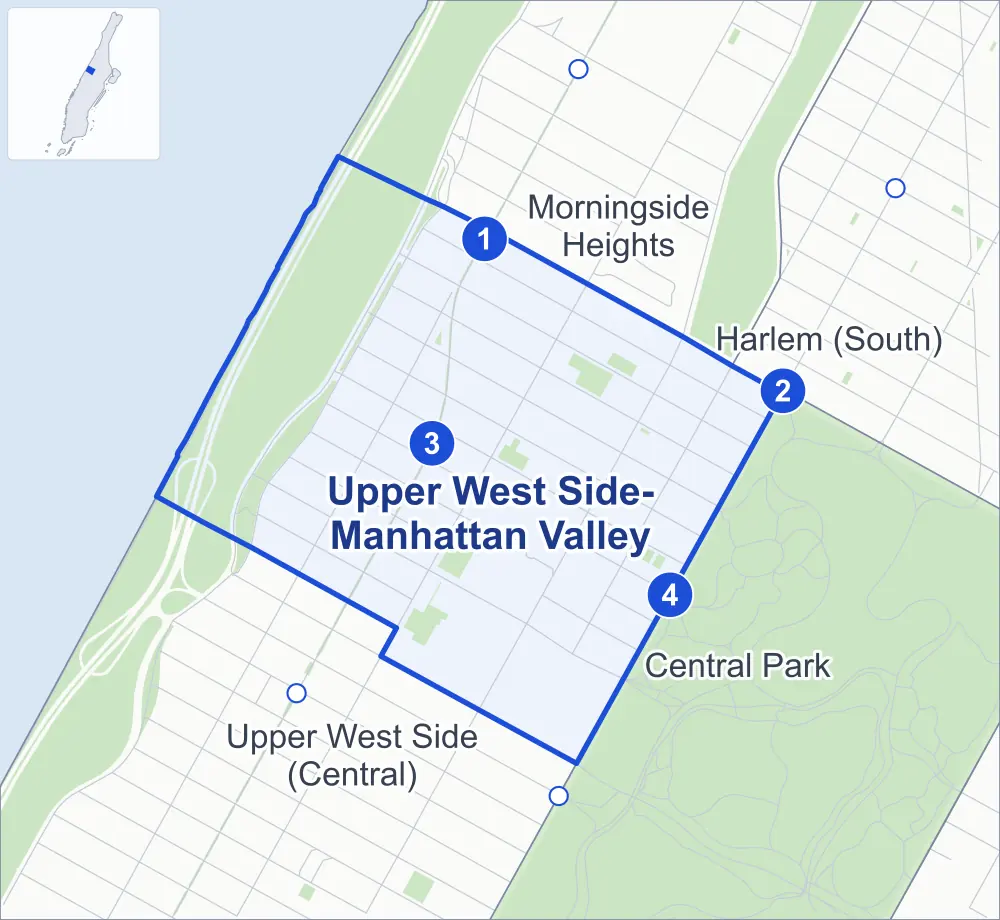
- Upper West Side-Manhattan Valley
- A neighboring area
- Park
- A station in the list
- Another station
Neighborhood areas and streets: NYC Department of City Planning. Parks: NYC Parks. Stations: MTA.
Neighboring areas
- Morningside Heights north
- Harlem (South) east
- Central Park southeast
- Upper West Side (Central) southwest
Subway stations
- Cathedral Pkwy (110 St) lines 1
- Cathedral Pkwy (110 St) lines B C
- 103 St lines 1
- 103 St lines B C
Getting around
Four subway stations and buses on 11 routes stop in or at the edge of Upper West Side-Manhattan Valley.
- 4 subway stations
- 11 local bus routes
Local bus routes
- M3
- M4
- M5
- M7
- M10
- M11
- M60-SBS
- M96
- M104
- M106
- M116
Safety record
Between 2021 and 2025, its corners averaged fewer police-reported crashes than the average Manhattan corner.
- 842 police-reported crashes at its corners
- 10.9 a corner, on average
- 13.4 the average Manhattan corner
Signal or safety changes on City record, at 61 of its corners
- Leading pedestrian intervals
- 40
- Accessible pedestrian signals
- 23
- Barnes Dance all-way crossings
- 16
- Enhanced crossings
- 4
- Turn calming
- 2
- Safety Improvement Projects
- 1
Camera tickets
In 2025 its corners had more school-zone speed camera tickets than red-light or bus-lane tickets.
- 0 red-light camera tickets
- 11,943 school-zone speed camera tickets at three corners
- 0 bus-lane camera tickets
- Most speed tickets
- Central Park West & 97th Street Transverse at West 97th Street, 10,068
People and homes
The 2020 Census counted 51,751 residents in Upper West Side-Manhattan Valley, about 110,100 per square mile.
- 26,533 homes, 2020 Census
- 474 homes added since April 2010, net, by City Planning's count
Half of its 799 residential lots hold buildings from 1910 or earlier, and 91% of them date from before 1940, by the City's tax lot records.
NYCHA developments
NYCHA's Douglass Addition, Douglass I, Douglass II and Rehab Program (Douglass Rehabs) developments lie wholly or partly within Upper West Side-Manhattan Valley, as does one more that NYCHA names by a building's address.
- Douglass Addition
- Within Upper West Side-Manhattan Valley
- Douglass I
- Within Upper West Side-Manhattan Valley
- Douglass II
- Within Upper West Side-Manhattan Valley
- Rehab Program (Douglass Rehabs)
- Within Upper West Side-Manhattan Valley; privately managed
Parks and landmarks
- Parkland
- 57.3 acres of NYC Parks property
- The largest pieces
- Riverside Park (50.8 acres), Frederick Douglass Playground (1.9 acres) and Happy Warrior Playground (1.5 acres)
- Designated landmarks
- The New-York Cancer Hospital, the Horn & Hardart Automat-Cafeteria, the Marseilles Hotel and the Association Residence for Respectable Aged Indigent Females, among others
- Historic districts
- Manhattan Avenue and Riverside-West 105th Street, wholly or partly within Upper West Side-Manhattan Valley
Streets and trees
- Trees
- 3,447 in NYC Parks' records, most often London planetree, thornless honeylocust and pin oak
- Street with the most corners
- Broadway, with 13 of the area's 77
- Height above sea level
- From 51 feet at Riverside Drive & West 98th Street to 116 feet at Columbus Avenue & West 104th Street
- Honorary street names
- 7 at its corners, enacted by local law
Schools and libraries
The City lists eight schools and one library in Upper West Side-Manhattan Valley.
- Public schools
- 6
- Charter and private schools
- 2
- Library
- Bloomingdale Library
Bike share and public art
By the station list of October 3, 2026, 11 bike-share stations stand in Upper West Side-Manhattan Valley. The City's public art inventory lists four works in the area, among them General Franz Sigel (1907), Firemen's Memorial (1913) and Isidor and Ida Straus (1915).
- 11 bike-share stations
- 4 works of public art
Public safety
How complaints are countedIn 2025 the NYPD recorded 490 major felonies at places in Upper West Side-Manhattan Valley.
Recorded by the NYPD at places in Upper West Side-Manhattan Valley
- 442 major felonies in 2024
- 2,036 other felonies, misdemeanors and violations in 2025
In 2025, on the streets along the edge of Upper West Side-Manhattan Valley, the NYPD recorded another 84 major felonies.
- Police precinct
- 24th
From January to June 2026 the NYPD recorded 247 major felonies at places in Upper West Side-Manhattan Valley, against 238 in the same months of 2025.
Sources: the NYPD's Complaint Data Historic, updated April 28, 2026, and Complaint Data Current (Year To Date), updated July 27, 2026, on NYC Open Data. Figures to June 30, 2026.
Street corners
- Amsterdam Avenue & Cathedral Parkway
- Amsterdam Avenue & West 99th Street
- Amsterdam Avenue & West 100th Street
- Amsterdam Avenue & West 101st Street
- Amsterdam Avenue & West 102nd Street
- Amsterdam Avenue & West 103rd Street
- Amsterdam Avenue & West 104th Street
- Amsterdam Avenue & West 105th Street
- Amsterdam Avenue & West 106th Street
- Amsterdam Avenue & West 107th Street
- Amsterdam Avenue & West 108th Street
- Amsterdam Avenue & West 109th Street
- Broadway & Cathedral Parkway
- Broadway & West 99th Street
- Broadway & West 100th Street
- Broadway & West 101st Street
- Broadway & West 102nd Street
- Broadway & West 103rd Street
- Broadway & West 104th Street
- Broadway & West 105th Street
- Broadway & West 106th Street
- Broadway & West 107th Street
- Broadway & West 108th Street
- Broadway & West 109th Street
- Broadway & West End Avenue
- Central Park West & 97th Street Transverse at West 97th Street
- Central Park West & Central Park Great Hill at West 103rd Street
- Central Park West & Central Park Great Hill at West 106th Street
- Central Park West & Frederick Douglass Circle
- Central Park West & West 100th Street
- Central Park West & West 101st Street
- Central Park West & West 102nd Street
- Central Park West & West 104th Street
- Central Park West & West 105th Street
- Central Park West & West 107th Street
- Central Park West & West 108th Street
- Central Park West & West 109th Street
- Columbus Avenue & West 100th Street
- Columbus Avenue & West 103rd Street
- Columbus Avenue & West 104th Street
- Columbus Avenue & West 105th Street
- Columbus Avenue & West 106th Street
- Columbus Avenue & West 107th Street
- Columbus Avenue & West 108th Street
- Columbus Avenue & West 109th Street
- Manhattan Avenue & Cathedral Parkway
- Manhattan Avenue & West 100th Street
- Manhattan Avenue & West 101st Street
- Manhattan Avenue & West 102nd Street
- Manhattan Avenue & West 103rd Street
- Manhattan Avenue & West 104th Street
- Manhattan Avenue & West 105th Street
- Manhattan Avenue & West 106th Street
- Manhattan Avenue & West 107th Street
- Manhattan Avenue & West 108th Street
- Manhattan Avenue & West 109th Street
- Riverside Drive & West 98th Street
- Riverside Drive & West 99th Street
- Riverside Drive & West 100th Street
- Riverside Drive & West 101st Street
- Riverside Drive & West 102nd Street
- Riverside Drive & West 103rd Street
- Riverside Drive & West 104th Street
- Riverside Drive & West 105th Street
- Riverside Drive & West 106th Street
- Riverside Drive & West 107th Street
- Riverside Drive & West 108th Street
- Riverside Drive & West 109th Street
- West End Avenue & West 98th Street
- West End Avenue & West 99th Street
- West End Avenue & West 100th Street
- West End Avenue & West 101st Street
- West End Avenue & West 102nd Street
- West End Avenue & West 103rd Street
- West End Avenue & West 104th Street
- West End Avenue & West 105th Street
- West End Avenue & West 106th Street
How the figures above are measured: Methodology.