Harlem (South)
Neighborhood · Manhattan
Harlem (South) fills the southern half of Central Harlem, from Central Park North at 110th Street up to 125th Street, east of Morningside Park and St. Nicholas Avenue.
- 0.52 square miles
- 47,113 residents, 2020 Census
- 89 street corners
- 6 subway stations
- 15 bus routes
The name goes back to Nieuw Haarlem, a settlement Peter Stuyvesant established in 1658, named after Haarlem in the Netherlands, and speculative building beside Mount Morris Park began in 1878. By World War I much of Harlem was a Black residential and business district, and after the war it became the center of the Harlem Renaissance. The Apollo Theater opened on 125th Street in 1934, and the Mount Morris Park Historic District was designated in 1971.
Sources: Harlem (Wikipedia); Harlem (Encyclopaedia Britannica); Mount Morris Park Historic District Designation Report (LP-0452) (NYC Landmarks Preservation Commission); Apollo History (Apollo Theater).
Harlem (South) borders six areas, and Adam Clayton Powell Jr Boulevard holds more of its corners than any other street, 18 of 89.
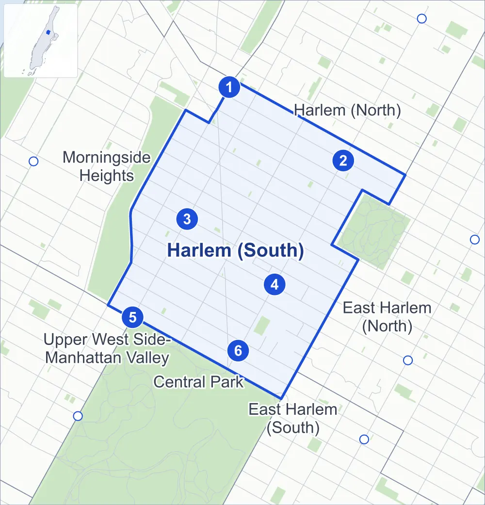
- Harlem (South)
- A neighboring area
- Park
- A station in the list
- Another station
Neighborhood areas and streets: NYC Department of City Planning. Parks: NYC Parks. Stations: MTA.
Neighboring areas
- Harlem (North) northeast
- East Harlem (North) east
- Central Park south
- East Harlem (South) south
- Upper West Side-Manhattan Valley southwest
- Morningside Heights northwest
Subway stations
- 125 St lines A B C D accessible
- 125 St lines 2 3
- 116 St lines B C
- 116 St lines 2 3
- Cathedral Pkwy (110 St) lines B C
- 110 St-Malcolm X Plaza lines 2 3
Getting around
Six subway stations and buses on 15 routes stop in or at the edge of Harlem (South).
- 6 subway stations
- 1 of them listed by the MTA as fully accessible
- 12 local bus routes
- 3 express bus routes
Local bus routes
- M1
- M2
- M3
- M4
- M7
- M10
- M60-SBS
- M100
- M101
- M102
- M116
- M125
Express bus routes
- BxM2
- BxM3
- BxM4
Safety record
Between 2021 and 2025, its corners averaged more police-reported crashes than the average Manhattan corner.
- 1,535 police-reported crashes at its corners
- 17.2 a corner, on average
- 13.4 the average Manhattan corner
Signal or safety changes on City record, at 65 of its corners
- Leading pedestrian intervals
- 56
- Accessible pedestrian signals
- 17
- Turn calming
- 6
- Barnes Dance all-way crossings
- 5
- Safety Improvement Projects
- 3
Camera tickets
In 2025 its corners had more bus-lane camera tickets than school-zone speed or red-light tickets.
- 0 red-light camera tickets
- 2,345 school-zone speed camera tickets at five corners
- 6,376 bus-lane camera tickets at two corners
- Most speed tickets
- St Nicholas Avenue & West 116th Street, 657
- Most bus-lane tickets
- West 125th Street & Adam Clayton Powell Jr Boulevard, 3,723
People and homes
The 2020 Census counted 47,113 residents in Harlem (South), about 90,600 per square mile.
- 22,076 homes, 2020 Census
- 2,346 homes added since April 2010, net, by City Planning's count
Half of its 1,650 residential lots hold buildings from 1901 or earlier, and 89% of them date from before 1940, by the City's tax lot records.
NYCHA development
NYCHA's King Towers development lies wholly or partly within Harlem (South).
Parks and landmarks
- Parkland
- 2.1 acres of NYC Parks property
- The largest piece
- Martin Luther King, Jr. Playground (1.1 acres)
- Designated landmarks
- The Mount Olive Fire Baptized Holiness Church, the Hotel Cecil & Minton's Playhouse, the Graham Court Apartments and the New York Public Library's 115th Street Branch, among others
- Historic district
- Mount Morris Park Historic District, wholly or partly within Harlem (South)
Streets and trees
- Trees
- 2,715 in NYC Parks' records, most often thornless honeylocust, Callery pear and London planetree
- Street with the most corners
- Adam Clayton Powell Jr Boulevard, with 18 of the area's 89
- Height above sea level
- From 16 feet at Central Park North & Frawley Circle to 52 feet at Cathedral Parkway & Frederick Douglass Circle
- Honorary street names
- 23 at its corners, enacted by local law
Schools and libraries
The City lists 24 schools and two libraries in Harlem (South).
- Public schools
- 9
- Charter and private schools
- 15
- Libraries
- Harlem Library and Harry Belafonte 115th Street Library
Bike share and public art
By the station list of October 3, 2026, 13 bike-share stations stand in Harlem (South). The City's public art inventory lists three works in the area: Brigadier General Winfield Scott Hancock (1891), Lafayette and Washington (1900) and Harriet Tubman Memorial (2008).
- 13 bike-share stations
- 3 works of public art
Public safety
How complaints are countedIn 2025 the NYPD recorded 728 major felonies at places in Harlem (South).
Recorded by the NYPD at places in Harlem (South)
- 880 major felonies in 2024 152 fewer in 2025
- 3,555 other felonies, misdemeanors and violations in 2025
In 2025, on the streets along the edge of Harlem (South), the NYPD recorded another 224 major felonies. Counting the streets along its edge, in 2025 the NYPD recorded 20.2 major felonies for every thousand residents the 2020 Census counted in Harlem (South).
- Police precinct
- 28th
From January to June 2026 the NYPD recorded 308 major felonies at places in Harlem (South), against 323 in the same months of 2025.
Sources: the NYPD's Complaint Data Historic, updated April 28, 2026, and Complaint Data Current (Year To Date), updated July 27, 2026, on NYC Open Data. Figures to June 30, 2026.
Street corners
- 5th Avenue & 112th Street
- 5th Avenue & 115th Street
- 5th Avenue & 117th Street
- 5th Avenue & 118th Street
- Adam Clayton Powell Jr Boulevard & Central Park North at Central Park Entrance Powell Boulevard
- Adam Clayton Powell Jr Boulevard & Central Park North at Central Park Exit Powell Boulevard
- Adam Clayton Powell Jr Boulevard & West 111th Street
- Adam Clayton Powell Jr Boulevard & West 112th Street
- Adam Clayton Powell Jr Boulevard & West 113th Street
- Adam Clayton Powell Jr Boulevard & West 114th Street
- Adam Clayton Powell Jr Boulevard & West 115th Street
- Adam Clayton Powell Jr Boulevard & West 116th Street
- Adam Clayton Powell Jr Boulevard & West 117th Street
- Adam Clayton Powell Jr Boulevard & West 118th Street
- Adam Clayton Powell Jr Boulevard & West 119th Street
- Adam Clayton Powell Jr Boulevard & West 121st Street
- Adam Clayton Powell Jr Boulevard & West 122nd Street
- Adam Clayton Powell Jr Boulevard & West 123rd Street
- Adam Clayton Powell Jr Boulevard & West 124th Street
- Adam Clayton Powell Jr Boulevard & West 126th Street
- Cathedral Parkway & Frederick Douglass Circle
- Central Park North & Frawley Circle
- Central Park North & Frederick Douglass Circle
- Frederick Douglass Boulevard & Frederick Douglass Circle
- Frederick Douglass Boulevard & West 111th Street
- Frederick Douglass Boulevard & West 112th Street
- Frederick Douglass Boulevard & West 113th Street
- Frederick Douglass Boulevard & West 114th Street
- Frederick Douglass Boulevard & West 115th Street
- Frederick Douglass Boulevard & West 116th Street
- Frederick Douglass Boulevard & West 117th Street
- Frederick Douglass Boulevard & West 118th Street
- Frederick Douglass Boulevard & West 119th Street
- Frederick Douglass Boulevard & West 120th Street
- Frederick Douglass Boulevard & West 121st Street
- Frederick Douglass Boulevard & West 122nd Street
- Frederick Douglass Boulevard & West 123rd Street
- Frederick Douglass Boulevard & West 124th Street
- Lenox Avenue & Central Park North
- Lenox Avenue & West 111th Street
- Lenox Avenue & West 112th Street
- Lenox Avenue & West 113th Street
- Lenox Avenue & West 114th Street
- Lenox Avenue & West 115th Street
- Lenox Avenue & West 116th Street
- Lenox Avenue & West 117th Street
- Lenox Avenue & West 118th Street
- Lenox Avenue & West 119th Street
- Lenox Avenue & West 121st Street
- Lenox Avenue & West 122nd Street
- Lenox Avenue & West 123rd Street
- Lenox Avenue & West 124th Street
- Manhattan Avenue & Morningside Avenue
- Manhattan Avenue & West 114th Street
- Manhattan Avenue & West 115th Street
- Manhattan Avenue & West 116th Street
- Manhattan Avenue & West 117th Street
- Manhattan Avenue & West 118th Street
- Manhattan Avenue & West 119th Street
- Manhattan Avenue & West 121st Street
- Morningside Avenue & West 116th Street
- Morningside Avenue & West 119th Street
- Morningside Avenue & West 121st Street
- St Nicholas Avenue & Frederick Douglass Boulevard
- St Nicholas Avenue & Manhattan Avenue
- St Nicholas Avenue & West 111th Street
- St Nicholas Avenue & West 112th Street
- St Nicholas Avenue & West 113th Street
- St Nicholas Avenue & West 114th Street
- St Nicholas Avenue & West 115th Street
- St Nicholas Avenue & West 116th Street
- St Nicholas Avenue & West 117th Street
- St Nicholas Avenue & West 118th Street
- St Nicholas Avenue & West 119th Street
- St Nicholas Avenue & West 120th Street
- St Nicholas Avenue & West 121st Street
- St Nicholas Avenue & West 122nd Street
- St Nicholas Avenue & West 123rd Street
- St Nicholas Avenue & West 125th Street
- West 120th Street & Adam Clayton Powell Jr Boulevard
- West 120th Street & Lenox Avenue
- West 120th Street & Manhattan Avenue
- West 120th Street & Morningside Avenue
- West 120th Street & Mount Morris Park West
- West 122nd Street & Manhattan Avenue
- West 124th Street & Mount Morris Park West
- West 125th Street & Adam Clayton Powell Jr Boulevard
- West 125th Street & Frederick Douglass Boulevard
- West 125th Street & Lenox Avenue
How the figures above are measured: Methodology.