East Harlem (South)
Neighborhood · Manhattan
East Harlem (South) runs from 96th Street to about 110th Street between Fifth Avenue and the East River, the lower half of the neighborhood also known as El Barrio.
- 0.60 square miles
- 59,814 residents, 2020 Census
- 113 street corners
- 4 subway stations
- 19 bus routes
An elevated line was built to Harlem in 1879 and 1880, and after World War I Puerto Rican and other Latin American migrants built a community in East Harlem's western blocks. Mount Sinai Hospital stands here, and along Fifth Avenue are the Museum of the City of New York, founded in 1923 and housed since 1932 in a Georgian Colonial Revival building, and El Museo del Barrio, founded in 1969 for Puerto Rican and Latin American art and culture.
Sources: East Harlem (Wikipedia); About the Museum (Museum of the City of New York); History & Mission (El Museo del Barrio).
East Harlem (South) borders five areas, and Lexington Avenue holds more of its corners than any other street, 17 of 113.
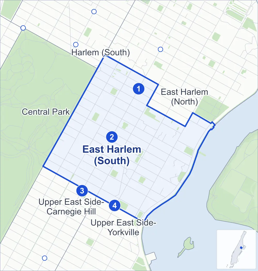
- East Harlem (South)
- A neighboring area
- Park
- A station in the list
- Another station
Neighborhood areas and streets: NYC Department of City Planning. Parks: NYC Parks. Stations: MTA.
Neighboring areas
- Harlem (South) north
- East Harlem (North) northeast
- Upper East Side-Yorkville south
- Upper East Side-Carnegie Hill southwest
- Central Park northwest
Subway stations
- 110 St lines 6
- 103 St lines 6
- 96 St lines 6
- 96 St lines Q accessible
Getting around
Four subway stations and buses on 19 routes stop in or at the edge of East Harlem (South).
- 4 subway stations
- 1 of them listed by the MTA as fully accessible
- 12 local bus routes
- 7 express bus routes
Local bus routes
- M1
- M2
- M3
- M4
- M15
- M15-SBS
- M96
- M98
- M101
- M102
- M103
- M106
Express bus routes
- BxM1
- BxM2
- BxM3
- BxM4
- BxM7
- BxM10
- BxM11
Safety record
Between 2021 and 2025, its corners averaged more police-reported crashes than the average Manhattan corner.
- 2,418 police-reported crashes at its corners
- 21.4 a corner, on average
- 13.4 the average Manhattan corner
- 6 corners with a clean record
Signal or safety changes on City record, at 92 of its corners
- Leading pedestrian intervals
- 72
- Accessible pedestrian signals
- 28
- Barnes Dance all-way crossings
- 19
- Turn calming
- 16
- Safety Improvement Projects
- 2
Camera tickets
In 2025 its corners had more school-zone speed camera tickets than bus-lane or red-light tickets.
- 32 red-light camera tickets at one corner
- 6,214 school-zone speed camera tickets at two corners
- 3,853 bus-lane camera tickets at two corners
- Most red-light tickets
- Park Avenue & East 106th Street, 32
- Most speed tickets
- 2nd Avenue & East 96th Street, 5,329
- Most bus-lane tickets
- 1st Avenue & East 106th Street, 3,330
People and homes
The 2020 Census counted 59,814 residents in East Harlem (South), about 99,700 per square mile.
- 26,386 homes, 2020 Census
- 3,880 homes added since April 2010, net, by City Planning's count
Half of its 703 residential lots hold buildings from 1910 or earlier, and 83% of them date from before 1940, by the City's tax lot records.
NYCHA developments
NYCHA's Carver, Clinton, East River, Lehman Village, Lexington, Washington and Wilson developments lie wholly or partly within East Harlem (South).
Parks and landmarks
- Parkland
- 16.2 acres of NYC Parks property
- The largest pieces
- East River Esplanade (3.4 acres), Poor Richard's Playground (1.6 acres) and Marx Brothers Playground (1.5 acres)
- Designated landmarks
- The Regina Angelorum, Public School 72, the Fire Engine Company No. 53 and Saint Cecilia's Church, among others
Streets and trees
- Trees
- 2,391 in NYC Parks' records, most often thornless honeylocust, London planetree and Japanese zelkova
- Street with the most corners
- Lexington Avenue, with 17 of the area's 113
- Height above sea level
- From 5 feet at FDR Drive & East 106th Street to 73 feet at 5th Avenue & East 97th Street
- Honorary street names
- 29 at its corners, enacted by local law
Schools and libraries
The City lists 37 schools and one library in East Harlem (South).
- Public schools
- 16
- Charter and private schools
- 21
- Library
- Aguilar Library
Bike share
By the station list of October 3, 2026, 16 bike-share stations stand in East Harlem (South).
- 16 bike-share stations
Public safety
How complaints are countedIn 2025 the NYPD recorded 911 major felonies at places in East Harlem (South).
Recorded by the NYPD at places in East Harlem (South)
- 970 major felonies in 2024
- 3,567 other felonies, misdemeanors and violations in 2025
In 2025, on the streets along the edge of East Harlem (South), the NYPD recorded another 141 major felonies. Counting the streets along its edge, in 2025 the NYPD recorded 17.6 major felonies for every thousand residents the 2020 Census counted in East Harlem (South).
- Police precinct
- 23rd
From January to June 2026 the NYPD recorded 371 major felonies at places in East Harlem (South), against 451 in the same months of 2025.
Sources: the NYPD's Complaint Data Historic, updated April 28, 2026, and Complaint Data Current (Year To Date), updated July 27, 2026, on NYC Open Data. Figures to June 30, 2026.
Street corners
- 1st Avenue & East 96th Street
- 1st Avenue & East 97th Street
- 1st Avenue & East 99th Street
- 1st Avenue & East 100th Street
- 1st Avenue & East 101st Street
- 1st Avenue & East 102nd Street
- 1st Avenue & East 103rd Street
- 1st Avenue & East 104th Street
- 1st Avenue & East 105th Street
- 1st Avenue & East 106th Street
- 1st Avenue & East 107th Street
- 1st Avenue & East 108th Street
- 1st Avenue & East 110th Street
- 2nd Avenue & East 96th Street
- 2nd Avenue & East 97th Street
- 2nd Avenue & East 99th Street
- 2nd Avenue & East 100th Street
- 2nd Avenue & East 101st Street
- 2nd Avenue & East 102nd Street
- 2nd Avenue & East 103rd Street
- 2nd Avenue & East 104th Street
- 2nd Avenue & East 105th Street
- 2nd Avenue & East 106th Street
- 2nd Avenue & East 108th Street
- 3rd Avenue & East 97th Street
- 3rd Avenue & East 98th Street
- 3rd Avenue & East 99th Street
- 3rd Avenue & East 100th Street
- 3rd Avenue & East 101st Street
- 3rd Avenue & East 102nd Street
- 3rd Avenue & East 103rd Street
- 3rd Avenue & East 104th Street
- 3rd Avenue & East 105th Street
- 3rd Avenue & East 106th Street
- 3rd Avenue & East 107th Street
- 3rd Avenue & East 108th Street
- 3rd Avenue & East 109th Street
- 3rd Avenue & East 110th Street
- 5th Avenue & 111th Street
- 5th Avenue & East 97th Street
- 5th Avenue & East 98th Street
- 5th Avenue & East 101st Street
- 5th Avenue & East 102nd Street
- 5th Avenue & East 103rd Street
- 5th Avenue & East 104th Street
- 5th Avenue & East 105th Street
- 5th Avenue & East 106th Street
- 5th Avenue & East 107th Street
- 5th Avenue & East 108th Street
- 5th Avenue & East 109th Street
- 5th Avenue & East Meadow Path (north-east)
- 5th Avenue & East Meadow Path (south-west)
- 5th Avenue & Frawley Circle
- 5th Avenue & Gustave L Levy Place
- Bobby Wagner Walk & East 103rd Street Footbridge
- Bobby Wagner Walk & East 111th Street Pedestrian Overpass
- East 97th Street & Pedestrian Path
- East 99th Street & Pedestrian Path
- East 102nd Street & Pedestrian Path
- East 110th Street & A New Street
- East 110th Street & Frawley Circle
- East 111th Street & A New Street
- FDR Drive & East 97th Street
- FDR Drive & East 99th Street
- FDR Drive & East 100th Street
- FDR Drive & East 102nd Street
- FDR Drive & East 103rd Street Footbridge
- FDR Drive & East 106th Street
- FDR Drive & East 107th Street
- FDR Drive & East 110th Street
- Lexington Avenue & East 96th Street
- Lexington Avenue & East 97th Street
- Lexington Avenue & East 98th Street
- Lexington Avenue & East 99th Street
- Lexington Avenue & East 100th Street
- Lexington Avenue & East 101st Street
- Lexington Avenue & East 102nd Street
- Lexington Avenue & East 103rd Street
- Lexington Avenue & East 104th Street
- Lexington Avenue & East 105th Street
- Lexington Avenue & East 106th Street
- Lexington Avenue & East 107th Street
- Lexington Avenue & East 108th Street
- Lexington Avenue & East 109th Street
- Lexington Avenue & East 110th Street
- Lexington Avenue & East 111th Street
- Lexington Avenue & East 112th Street
- Madison Avenue & East 97th Street
- Madison Avenue & East 98th Street
- Madison Avenue & East 99th Street
- Madison Avenue & East 101st Street
- Madison Avenue & East 102nd Street
- Madison Avenue & East 103rd Street
- Madison Avenue & East 104th Street
- Madison Avenue & East 105th Street
- Madison Avenue & East 106th Street
- Madison Avenue & East 107th Street
- Madison Avenue & East 108th Street
- Madison Avenue & East 109th Street
- Madison Avenue & East 110th Street
- Madison Avenue & East 111th Street
- Madison Avenue & East 112th Street
- Park Avenue & East 97th Street
- Park Avenue & East 102nd Street
- Park Avenue & East 103rd Street
- Park Avenue & East 104th Street
- Park Avenue & East 105th Street
- Park Avenue & East 106th Street
- Park Avenue & East 107th Street
- Park Avenue & East 108th Street
- Park Avenue & East 109th Street
- Park Avenue & East 110th Street
- Park Avenue & East 111th Street
How the figures above are measured: Methodology.