East Harlem (North)
Neighborhood · Manhattan
East Harlem (North) stretches from about 110th Street to the Harlem River between Fifth Avenue and the East River, covering the upper part of East Harlem.
- 0.94 square miles
- 64,655 residents, 2020 Census
- 176 street corners
- 2 subway stations
- 21 bus routes
The first Italian immigrants arrived in East Harlem in 1878, and it became the first part of Manhattan to be called Little Italy; Thomas Jefferson Park opened on First Avenue in 1905, and its pool followed in 1936. Landmarks include the Romanesque Revival Harlem Courthouse, built from 1891 to 1893 on East 121st Street, and Marcus Garvey Park on the area's western edge, where a 47-foot cast-iron fire watchtower was erected in 1856.
Sources: East Harlem (Wikipedia); Thomas Jefferson Park (NYC Parks); The Harlem Courthouse, 170 East 121st Street (LP-0297, August 2, 1967) (NYC Landmarks Preservation Commission); Marcus Garvey Park (NYC Parks).
East Harlem (North) borders four areas, and Harlem River Drive holds more of its corners than any other street, 31 of 176.
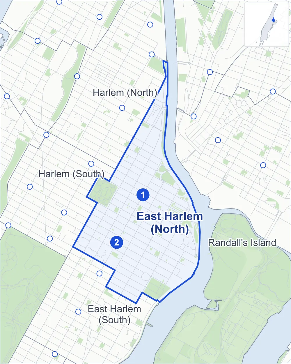
- East Harlem (North)
- A neighboring area
- Park
- A station in the list
- Another station
Neighborhood areas and streets: NYC Department of City Planning. Parks: NYC Parks. Stations: MTA.
Neighboring areas
- Harlem (North) north
- Randall's Island east
- East Harlem (South) southwest
- Harlem (South) west
Subway stations
- 125 St lines 4 5 6 accessible
- 116 St lines 6
Getting around
Two subway stations and buses on 21 routes stop in or at the edge of East Harlem (North).
- 2 subway stations
- 1 of them listed by the MTA as fully accessible
- 13 local bus routes
- 8 express bus routes
Local bus routes
- Bx33
- M1
- M15
- M15-SBS
- M35
- M60-SBS
- M98
- M101
- M102
- M103
- M116
- M125
- T102
Express bus routes
- BxM2
- BxM3
- BxM4
- BxM6
- BxM7
- BxM8
- BxM9
- BxM10
Safety record
Between 2021 and 2025, its corners averaged more police-reported crashes than the average Manhattan corner.
- 3,458 police-reported crashes at its corners
- 19.6 a corner, on average
- 13.4 the average Manhattan corner
- 29 corners with a clean record
Signal or safety changes on City record, at 108 of its corners
- Leading pedestrian intervals
- 96
- Turn calming
- 20
- Accessible pedestrian signals
- 17
- Barnes Dance all-way crossings
- 8
Camera tickets
In 2025 its corners had more school-zone speed camera tickets than bus-lane or red-light tickets.
- 298 red-light camera tickets at one corner
- 6,408 school-zone speed camera tickets at ten corners
- 3,693 bus-lane camera tickets at four corners
- Most red-light tickets
- Madison Avenue Bridge & Madison Avenue, 298
- Most speed tickets
- 5th Avenue & 135th Street, 2,139
- Most bus-lane tickets
- 5th Avenue & 125th Street, 1,905
People and homes
The 2020 Census counted 64,655 residents in East Harlem (North), about 68,800 per square mile.
- 28,324 homes, 2020 Census
- 3,635 homes added since April 2010, net, by City Planning's count
Half of its 1,466 residential lots hold buildings from 1910 or earlier, and 76% of them date from before 1940, by the City's tax lot records.
NYCHA developments
NYCHA's Jefferson, Johnson, Lincoln, Taft and Wagner developments lie wholly or partly within East Harlem (North).
Parks and landmarks
- Parkland
- 60.6 acres of NYC Parks property
- The largest pieces
- Marcus Garvey Park (19.7 acres), Thomas Jefferson Park (13.2 acres) and Harlem River Park (5.9 acres)
- Designated landmarks
- The New York Public Library's 125th Street Branch, St. Paul Roman Catholic Church, the Fire Hook and Ladder Company No. 14 and the Mount Morris Bank Building, among others
Streets and trees
- Trees
- 4,553 in NYC Parks' records, most often thornless honeylocust, London planetree and pin oak
- Street with the most corners
- Harlem River Drive, with 31 of the area's 176
- Height above sea level
- From 7 feet at 1st Avenue & East 117th Street to 36 feet at Madison Avenue & East 117th Street
- Honorary street names
- 31 at its corners, enacted by local law
Schools and libraries
The City lists 34 schools and one library in East Harlem (North).
- Public schools
- 20
- Charter and private schools
- 14
- Library
- 125th Street Library
Bike share and public art
By the station list of October 3, 2026, 26 bike-share stations stand in East Harlem (North). The City's public art inventory lists six works in the area, among them Senator Robert F. Wagner (1959), Growth (1985) and Crack Is Wack (1986).
- 26 bike-share stations
- 6 works of public art
Public safety
How complaints are countedIn 2025 the NYPD recorded 1,232 major felonies at places in East Harlem (North).
Recorded by the NYPD at places in East Harlem (North)
- 1,371 major felonies in 2024 139 fewer in 2025
- 5,319 other felonies, misdemeanors and violations in 2025
In 2025, on the streets along the edge of East Harlem (North), the NYPD recorded another 213 major felonies. Counting the streets along its edge, in 2025 the NYPD recorded 22.3 major felonies for every thousand residents the 2020 Census counted in East Harlem (North).
- Police precincts
- 25th (most of the area), 23rd, 28th, 32nd
From January to June 2026 the NYPD recorded 478 major felonies at places in East Harlem (North), against 609 in the same months of 2025.
Sources: the NYPD's Complaint Data Historic, updated April 28, 2026, and Complaint Data Current (Year To Date), updated July 27, 2026, on NYC Open Data. Figures to June 30, 2026.
Street corners
- 1st Avenue & East 109th Street
- 1st Avenue & East 111th Street
- 1st Avenue & East 112th Street
- 1st Avenue & East 114th Street
- 1st Avenue & East 115th Street
- 1st Avenue & East 116th Street
- 1st Avenue & East 117th Street
- 1st Avenue & East 118th Street
- 1st Avenue & East 119th Street
- 1st Avenue & East 120th Street
- 1st Avenue & East 124th Street
- 1st Avenue & East 125th Street
- 1st Avenue & East 126th Street
- 1st Avenue & Paladino Avenue
- 1st Avenue & Thomas Jefferson Park Path
- 1st Avenue & Willis Avenue Bridge Bike Path
- 2nd Avenue & East 109th Street
- 2nd Avenue & East 110th Street
- 2nd Avenue & East 111th Street
- 2nd Avenue & East 112th Street
- 2nd Avenue & East 113th Street
- 2nd Avenue & East 115th Street
- 2nd Avenue & East 116th Street
- 2nd Avenue & East 117th Street
- 2nd Avenue & East 118th Street
- 2nd Avenue & East 119th Street
- 2nd Avenue & East 120th Street
- 2nd Avenue & East 121st Street
- 2nd Avenue & East 122nd Street
- 2nd Avenue & East 123rd Street
- 2nd Avenue & East 124th Street
- 2nd Avenue & East 124th Street at RFK Bridge
- 2nd Avenue & East 125th Street
- 2nd Avenue & East 126th Street
- 2nd Avenue & East 127th Street
- 2nd Avenue & East 128th Street
- 2nd Avenue & Harlem River Drive
- 3rd Avenue & 3rd Avenue-East 128th Street Pedestrian Overpass
- 3rd Avenue & East 111th Street
- 3rd Avenue & East 112th Street
- 3rd Avenue & East 115th Street
- 3rd Avenue & East 116th Street
- 3rd Avenue & East 117th Street
- 3rd Avenue & East 118th Street
- 3rd Avenue & East 119th Street
- 3rd Avenue & East 120th Street
- 3rd Avenue & East 121st Street
- 3rd Avenue & East 122nd Street
- 3rd Avenue & East 123rd Street
- 3rd Avenue & East 124th Street
- 3rd Avenue & East 125th Street
- 3rd Avenue & East 126th Street
- 3rd Avenue & East 127th Street
- 3rd Avenue & East 128th Street
- 3rd Avenue Bridge & East 128th Street
- 3rd Avenue Bridge & East 129th Street
- 3rd Avenue Bridge & Harlem River Drive
- 3rd Avenue Bridge Pedestrian and Bike Path & 3rd Avenue-East 128th Street Pedestrian Overpass
- 5th Avenue & 116th Street
- 5th Avenue & 119th Street
- 5th Avenue & 120th Street
- 5th Avenue & 124th Street
- 5th Avenue & 125th Street
- 5th Avenue & 126th Street
- 5th Avenue & 128th Street
- 5th Avenue & 129th Street
- 5th Avenue & 130th Street
- 5th Avenue & 135th Street
- 5th Avenue & 139th Street
- 5th Avenue & West 141st Street
- Bobby Wagner Walk & East 120th Street Pedestrian Overpass
- East 114th Street & Thomas Jefferson Park Path
- East 115th Street & Pleasant Avenue
- East 116th Street & FDR Drive
- East 116th Street & Pleasant Avenue
- East 117th Street & Pleasant Avenue
- East 118th Street & Pleasant Avenue
- East 119th Street & Pleasant Avenue
- East 120th Street & Paladino Avenue
- East 120th Street & Pleasant Avenue
- East 120th Street & Sylvan Place
- East 121st Street & Sylvan Court
- East 124th Street & RFK Bridge
- East 125th Street & RFK Bridge
- East 126th Street & Harlem River Drive
- East 127th Street & Harlem River Drive
- East 127th Street & Harlem River Drive (Exit 19)
- East 128th Street & 3rd Avenue-East 128th Street Pedestrian Overpass
- East 135th Street & Harlem River Drive
- FDR Drive & East 111th Street Pedestrian Overpass
- FDR Drive & East 120th Street Pedestrian Overpass
- FDR Drive & Harlem River Drive
- FDR Drive & Harlem River Drive at RFK Bridge
- Harlem River Drive & 3rd Avenue Bridge
- Harlem River Drive & 3rd Avenue Bridge Pedestrian and Bike Path
- Harlem River Drive & 5th Avenue at Pedestrian Overpass
- Harlem River Drive & 5th Avenue at West 142nd Street
- Harlem River Drive & 145th Street Bridge Pedestrian and Bike Path
- Harlem River Drive & East 139th Street
- Harlem River Drive & FDR Drive
- Harlem River Drive & FDR Drive (Exit 17)
- Harlem River Drive & Madison Avenue
- Harlem River Drive & Park Avenue
- Harlem River Drive & RFK Bridge
- Harlem River Drive & RFK Bridge (E 124 and 125th Street)
- Harlem River Drive & RFK Bridge (FDR and Harlem River Drive)
- Harlem River Drive & RFK Bridge (FDR Drive, north)
- Harlem River Drive & RFK Bridge (FDR Drive, south)
- Harlem River Drive & RFK Bridge Pedestrian and Bike Path
- Harlem River Drive & West 142nd Street Pedestrian Opas
- Harlem River Drive & Willis Avenue Bridge
- Lexington Avenue & East 115th Street
- Lexington Avenue & East 116th Street
- Lexington Avenue & East 117th Street
- Lexington Avenue & East 118th Street
- Lexington Avenue & East 119th Street
- Lexington Avenue & East 120th Street
- Lexington Avenue & East 121st Street
- Lexington Avenue & East 122nd Street
- Lexington Avenue & East 123rd Street
- Lexington Avenue & East 124th Street
- Lexington Avenue & East 125th Street
- Lexington Avenue & East 126th Street
- Lexington Avenue & East 127th Street
- Lexington Avenue & East 128th Street
- Lexington Avenue & East 129th Street
- Lexington Avenue & East 130th Street
- Lexington Avenue & East 131st Street
- Madison Avenue & East 115th Street
- Madison Avenue & East 116th Street
- Madison Avenue & East 117th Street
- Madison Avenue & East 118th Street
- Madison Avenue & East 119th Street
- Madison Avenue & East 120th Street
- Madison Avenue & East 121st Street
- Madison Avenue & East 122nd Street
- Madison Avenue & East 123rd Street
- Madison Avenue & East 124th Street
- Madison Avenue & East 125th Street
- Madison Avenue & East 126th Street
- Madison Avenue & East 127th Street
- Madison Avenue & East 128th Street
- Madison Avenue & East 129th Street
- Madison Avenue & East 130th Street
- Madison Avenue & East 131st Street
- Madison Avenue & East 132nd Street
- Madison Avenue & East 135th Street
- Madison Avenue Bridge & Madison Avenue
- Park Avenue & East 112th Street
- Park Avenue & East 115th Street
- Park Avenue & East 116th Street
- Park Avenue & East 117th Street
- Park Avenue & East 118th Street
- Park Avenue & East 119th Street
- Park Avenue & East 120th Street
- Park Avenue & East 121st Street
- Park Avenue & East 122nd Street
- Park Avenue & East 123rd Street
- Park Avenue & East 124th Street
- Park Avenue & East 125th Street
- Park Avenue & East 126th Street
- Park Avenue & East 127th Street
- Park Avenue & East 128th Street
- Park Avenue & East 129th Street
- Park Avenue & East 130th Street
- Park Avenue & East 131st Street
- Park Avenue & East 132nd Street
- Park Avenue & Harlem River Drive
- Pedestrian Overpass & West 142nd Street Pedestrian Opas
- Pleasant Avenue & East 114th Street
- RFK Bridge & RFK Bridge Pedestrian and Bike Path
- West 121st Street & Mount Morris Park West
- West 122nd Street & Mount Morris Park West
- West 123rd Street & Mount Morris Park West
- Willis Avenue Bridge & 1st Avenue
- Willis Avenue Bridge & 1st Avenue at East 125th Street
How the figures above are measured: Methodology.