Harlem (North)
Neighborhood · Manhattan
Harlem (North) takes in the northern half of Central Harlem, reaching up to 155th Street between Fifth Avenue and St. Nicholas and Edgecombe Avenues.
- 0.85 square miles
- 83,327 residents, 2020 Census
- 128 street corners
- 6 subway stations
- 10 bus routes
Its landmarks include the King Model Houses, four rows commissioned in 1891 on West 138th and 139th Streets that became known as Strivers' Row in the 1920s and 1930s, and the Harlem River Houses, finished in 1937 as the city's first federally funded, built and owned housing project. The New York Public Library's Schomburg Center for Research in Black Culture traces its start to a department of Black literature and history that opened at the 135th Street branch library in 1925.
Sources: Harlem (Wikipedia); St. Nicholas Historic District, Borough of Manhattan (LP-0322, March 16, 1967) (NYC Landmarks Preservation Commission); Harlem River Houses, 151st to 153rd Streets, Macombs Place to Harlem River Drive (LP-0894, 1975) (NYC Landmarks Preservation Commission); Schomburg's Library - Arturo (Arthur) Schomburg Research Guide (New York Public Library).
Harlem (North) borders five areas, and Frederick Douglass Boulevard holds more of its corners than any other street, 33 of 128.
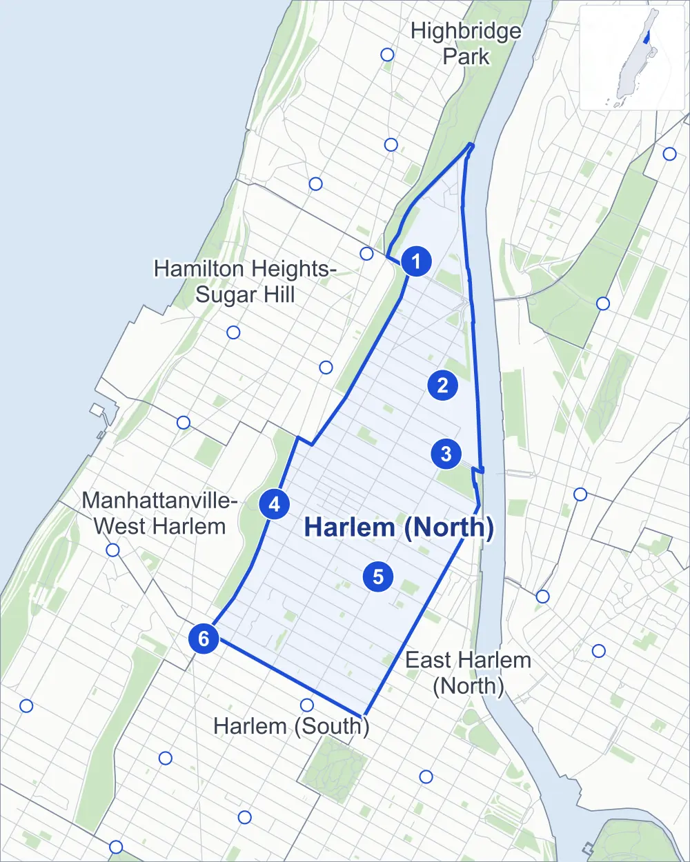
- Harlem (North)
- A neighboring area
- Park
- A station in the list
- Another station
Neighborhood areas and streets: NYC Department of City Planning. Parks: NYC Parks. Stations: MTA.
Neighboring areas
- Hamilton Heights-Sugar Hill north
- Highbridge Park north
- East Harlem (North) southeast
- Manhattanville-West Harlem southwest
- Harlem (South) southwest
Subway stations
- 155 St lines B D
- Harlem-148 St lines 3 accessible
- 145 St lines 3
- 135 St lines B C
- 135 St lines 2 3 accessible
- 125 St lines A B C D accessible
Getting around
Six subway stations and buses on ten routes stop in or at the edge of Harlem (North).
- 6 subway stations
- 3 of them listed by the MTA as fully accessible
- 10 local bus routes
Local bus routes
- Bx6
- Bx19
- Bx33
- BX92
- M1
- M2
- M3
- M7
- M10
- M102
Safety record
Between 2021 and 2025, its corners averaged more police-reported crashes than the average Manhattan corner.
- 2,706 police-reported crashes at its corners
- 21.1 a corner, on average
- 13.4 the average Manhattan corner
- 6 corners with a clean record
Signal or safety changes on City record, at 90 of its corners
- Leading pedestrian intervals
- 68
- Accessible pedestrian signals
- 36
- Barnes Dance all-way crossings
- 17
- Turn calming
- 5
- Safety Improvement Projects
- 2
Camera tickets
In 2025 its corners had more school-zone speed camera tickets than red-light or bus-lane tickets.
- 0 red-light camera tickets
- 6,039 school-zone speed camera tickets at five corners
- 0 bus-lane camera tickets
- Most speed tickets
- Adam Clayton Powell Jr Boulevard & West 145th Street, 3,138
People and homes
The 2020 Census counted 83,327 residents in Harlem (North), about 98,000 per square mile.
- 39,553 homes, 2020 Census
- 2,673 homes added since April 2010, net, by City Planning's count
Half of its 2,012 residential lots hold buildings from 1910 or earlier, and 89% of them date from before 1940, by the City's tax lot records.
NYCHA developments
NYCHA's Drew-Hamilton, Polo Grounds Towers, Rangel and Saint Nicholas developments lie wholly or partly within Harlem (North).
Parks and landmarks
- Parkland
- 25.4 acres of NYC Parks property
- The largest pieces
- Brigadier General Charles Young Playground (6.6 acres), Holcombe Rucker Park (3 acres) and Frederick Johnson Playground (2.5 acres)
- Designated landmarks
- The Harlem River Houses; the Dunbar Apartments; the Abyssinian Baptist Church, Community House; and the Harlem YMCA, among others
- Historic districts
- Central Harlem – West 130th-132nd Streets and St. Nicholas, wholly or partly within Harlem (North)
Streets and trees
- Trees
- 4,085 in NYC Parks' records, most often thornless honeylocust, London planetree and Callery pear
- Street with the most corners
- Frederick Douglass Boulevard, with 33 of the area's 128
- Height above sea level
- From 7 feet at 5th Avenue & West 143rd Street to 43 feet at St Nicholas Avenue & West 140th Street
- Honorary street names
- 22 at its corners, enacted by local law
Schools and libraries
The City lists 28 schools and three libraries in Harlem (North).
- Public schools
- 15
- Charter and private schools
- 13
- Libraries
- Countee Cullen Library, Macomb's Bridge Library and Schomburg Center for Research in Black Culture
Bike share and public art
By the station list of October 3, 2026, 26 bike-share stations stand in Harlem (North). The City's public art inventory lists three works in the area: Frederick Johnson Memorial (1971), Tree of Hope III (1972) and Bill "Bojangles" Robinson Mural (1992).
- 26 bike-share stations
- 3 works of public art
Public safety
How complaints are countedIn 2025 the NYPD recorded 1,215 major felonies at places in Harlem (North).
Recorded by the NYPD at places in Harlem (North)
- 1,231 major felonies in 2024
- 5,264 other felonies, misdemeanors and violations in 2025
In 2025, on the streets along the edge of Harlem (North), the NYPD recorded another 184 major felonies. Counting the streets along its edge, in 2025 the NYPD recorded 16.8 major felonies for every thousand residents the 2020 Census counted in Harlem (North).
- Police precincts
- 32nd (most of the area), 28th
From January to June 2026 the NYPD recorded 603 major felonies at places in Harlem (North), against 595 in the same months of 2025.
Sources: the NYPD's Complaint Data Historic, updated April 28, 2026, and Complaint Data Current (Year To Date), updated July 27, 2026, on NYC Open Data. Figures to June 30, 2026.
Street corners
- 5th Avenue & 127th Street
- 5th Avenue & 131st Street
- 5th Avenue & 132nd Street
- 5th Avenue & 138th Street
- 5th Avenue & West 137th Street
- 5th Avenue & West 143rd Street
- Adam Clayton Powell Jr Boulevard & Macombs Dam Bridge Pedestrian Path
- Adam Clayton Powell Jr Boulevard & Macombs Place
- Adam Clayton Powell Jr Boulevard & West 127th Street
- Adam Clayton Powell Jr Boulevard & West 128th Street
- Adam Clayton Powell Jr Boulevard & West 129th Street
- Adam Clayton Powell Jr Boulevard & West 130th Street
- Adam Clayton Powell Jr Boulevard & West 131st Street
- Adam Clayton Powell Jr Boulevard & West 132nd Street
- Adam Clayton Powell Jr Boulevard & West 133rd Street
- Adam Clayton Powell Jr Boulevard & West 134th Street
- Adam Clayton Powell Jr Boulevard & West 135th Street
- Adam Clayton Powell Jr Boulevard & West 136th Street
- Adam Clayton Powell Jr Boulevard & West 137th Street
- Adam Clayton Powell Jr Boulevard & West 138th Street
- Adam Clayton Powell Jr Boulevard & West 139th Street
- Adam Clayton Powell Jr Boulevard & West 140th Street
- Adam Clayton Powell Jr Boulevard & West 141st Street
- Adam Clayton Powell Jr Boulevard & West 142nd Street
- Adam Clayton Powell Jr Boulevard & West 143rd Street
- Adam Clayton Powell Jr Boulevard & West 144th Street
- Adam Clayton Powell Jr Boulevard & West 145th Street
- Adam Clayton Powell Jr Boulevard & West 146th Street
- Adam Clayton Powell Jr Boulevard & West 147th Street
- Adam Clayton Powell Jr Boulevard & West 148th Street
- Adam Clayton Powell Jr Boulevard & West 149th Street
- Adam Clayton Powell Jr Boulevard & West 150th Street
- Adam Clayton Powell Jr Boulevard & West 151st Street
- Adam Clayton Powell Jr Boulevard & West 152nd Street
- Adam Clayton Powell Jr Boulevard & West 153rd Street
- Adam Clayton Powell Jr Boulevard & West 155th Street
- Adam Clayton Powell Jr Boulevard & West 155th Street at Macombs Place
- Bradhurst Avenue & West 146th Street
- Bradhurst Avenue & West 147th Street
- Bradhurst Avenue & West 148th Street
- Bradhurst Avenue & West 153rd Street
- Edgecombe Avenue & West 135th Street
- Edgecombe Avenue & West 136th Street
- Edgecombe Avenue & West 137th Street
- Edgecombe Avenue & West 138th Street
- Edgecombe Avenue & West 139th Street
- Edgecombe Avenue & West 140th Street
- Edgecombe Avenue & West 141st Street
- Frederick Douglass Boulevard & Harlem River Drive
- Frederick Douglass Boulevard & West 126th Street
- Frederick Douglass Boulevard & West 127th Street
- Frederick Douglass Boulevard & West 128th Street
- Frederick Douglass Boulevard & West 129th Street
- Frederick Douglass Boulevard & West 130th Street
- Frederick Douglass Boulevard & West 131st Street
- Frederick Douglass Boulevard & West 132nd Street
- Frederick Douglass Boulevard & West 133rd Street
- Frederick Douglass Boulevard & West 134th Street
- Frederick Douglass Boulevard & West 135th Street
- Frederick Douglass Boulevard & West 136th Street
- Frederick Douglass Boulevard & West 137th Street
- Frederick Douglass Boulevard & West 138th Street
- Frederick Douglass Boulevard & West 139th Street
- Frederick Douglass Boulevard & West 140th Street
- Frederick Douglass Boulevard & West 141st Street
- Frederick Douglass Boulevard & West 142nd Street
- Frederick Douglass Boulevard & West 143rd Street
- Frederick Douglass Boulevard & West 144th Street
- Frederick Douglass Boulevard & West 145th Street
- Frederick Douglass Boulevard & West 146th Street
- Frederick Douglass Boulevard & West 147th Street
- Frederick Douglass Boulevard & West 148th Street
- Frederick Douglass Boulevard & West 149th Street
- Frederick Douglass Boulevard & West 150th Street
- Frederick Douglass Boulevard & West 150th Street at Macombs Place
- Frederick Douglass Boulevard & West 151st Street
- Frederick Douglass Boulevard & West 152nd Street
- Frederick Douglass Boulevard & West 153rd Street
- Frederick Douglass Boulevard & West 154th Street
- Frederick Douglass Boulevard & West 155th Street
- Harlem River Drive & 145th Street Bridge
- Harlem River Drive & Frederick Douglass Boulevard
- Harlem River Drive & Harlem River Driveway (north-east)
- Harlem River Drive & Harlem River Driveway (south-west)
- Harlem River Drive & West 155th Street
- Harlem River Driveway & Harlem River Drive
- Lenox Avenue & West 126th Street
- Lenox Avenue & West 127th Street
- Lenox Avenue & West 128th Street
- Lenox Avenue & West 129th Street
- Lenox Avenue & West 130th Street
- Lenox Avenue & West 131st Street
- Lenox Avenue & West 132nd Street
- Lenox Avenue & West 133rd Street
- Lenox Avenue & West 134th Street
- Lenox Avenue & West 135th Street
- Lenox Avenue & West 136th Street
- Lenox Avenue & West 139th Street
- Lenox Avenue & West 140th Street
- Lenox Avenue & West 141st Street
- Lenox Avenue & West 142nd Street
- Lenox Avenue & West 143rd Street
- Lenox Avenue & West 144th Street
- Macombs Place & West 154th Street
- Madison Avenue Bridge & 5th Avenue
- St Nicholas Avenue & West 127th Street
- St Nicholas Avenue & West 128th Street
- St Nicholas Avenue & West 129th Street
- St Nicholas Avenue & West 130th Street
- St Nicholas Avenue & West 138th Street
- St Nicholas Avenue & West 140th Street
- West 134th Street & Lenox Terrace Place
- West 135th Street & Lenox Terrace Place
- West 137th Street & Lenox Avenue
- West 138th Street & Lenox Avenue
- West 139th Street & Pedestrian Path
- West 142nd Street & Chisum Place
- West 145th Street & Bradhurst Avenue
- West 145th Street & Lenox Avenue
- West 146th Street & Esplanade Gardens Plaza
- West 147th Street & Esplanade Gardens Plaza
- West 151st Street & Bradhurst Avenue
- West 151st Street & Macombs Place
- West 152nd Street & Macombs Place
- West 153rd Street & Macombs Dam Bridge Pedestrian Path
- West 153rd Street & Macombs Place
- West 155th Street & Bradhurst Avenue
- West 155th Street & Macombs Dam Bridge Pedestrian Path
How the figures above are measured: Methodology.