Hamilton Heights-Sugar Hill
Neighborhood · Manhattan
Hamilton Heights-Sugar Hill occupies the northern end of West Harlem, reaching from the Hudson River toward Edgecombe Avenue and up to 155th Street.
- 0.57 square miles
- 49,410 residents, 2020 Census
- 102 street corners
- 4 subway stations
- 11 bus routes
Alexander Hamilton bought land here in 1799 and completed his country house, the Grange, in 1802; rowhouses arrived from the mid-1880s, and apartment houses followed the opening of the IRT subway in 1904. In the mid-1920s the area became known as Sugar Hill, a name suggesting a sweet and prosperous life, and in the 1930s and 1940s many Black professionals in law, medicine, business and the arts made their homes here. Several historic districts, the first designated in 1974, now protect its streets.
Sources: The District (Manhattan Community Board 9); Hamilton Heights/Sugar Hill Historic District Designation Report (LP-2064) (NYC Landmarks Preservation Commission); History & Culture - Hamilton Grange National Memorial (National Park Service); Hamilton Heights/Sugar Hill Historic District and Extension (Historic Districts Council).
Hamilton Heights-Sugar Hill borders three areas, and Amsterdam Avenue and Riverside Drive hold more of its corners than any other street, 17 each of 102.
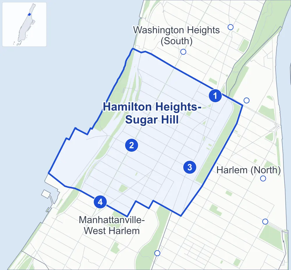
- Hamilton Heights-Sugar Hill
- A neighboring area
- Park
- A station in the list
- Another station
Neighborhood areas and streets: NYC Department of City Planning. Parks: NYC Parks. Stations: MTA.
Neighboring areas
- Washington Heights (South) northeast
- Harlem (North) east
- Manhattanville-West Harlem southwest
Subway stations
- 155 St lines C
- 145 St lines 1
- 145 St lines A B C D
- 137 St-City College lines 1
Getting around
Four subway stations and buses on 11 routes stop in or at the edge of Hamilton Heights-Sugar Hill.
- 4 subway stations
- 11 local bus routes
Local bus routes
- Bx6
- Bx6-SBS
- Bx19
- M2
- M3
- M4
- M5
- M11
- M100
- M101
- T204
Safety record
Between 2021 and 2025, its corners averaged more police-reported crashes than the average Manhattan corner.
- 1,542 police-reported crashes at its corners
- 15.1 a corner, on average
- 13.4 the average Manhattan corner
- 2 corners with a clean record
Signal or safety changes on City record, at 43 of its corners
- Leading pedestrian intervals
- 33
- Accessible pedestrian signals
- 12
- Barnes Dance all-way crossings
- 6
- Turn calming
- 4
- Enhanced crossings
- 2
Camera tickets
In 2025 its corners had more school-zone speed camera tickets than red-light or bus-lane tickets.
- 0 red-light camera tickets
- 17,339 school-zone speed camera tickets at five corners
- 0 bus-lane camera tickets
- Most speed tickets
- Harlem River Driveway & West 155th Street, 9,805
People and homes
The 2020 Census counted 49,410 residents in Hamilton Heights-Sugar Hill, about 86,700 per square mile.
- 20,990 homes, 2020 Census
- 915 homes added since April 2010, net, by City Planning's count
Half of its 1,441 residential lots hold buildings from 1907 or earlier, and 97% of them date from before 1940, by the City's tax lot records.
Parks and landmarks
- Parkland
- 42.5 acres of NYC Parks property
- The largest pieces
- Recreational Area (17.5 acres), Jackie Robinson Park (13 acres) and Riverside Park (9.5 acres)
- Designated landmarks
- The Beaumont Apartments, the Hamilton Theater, the New York Public Library's Hamilton Grange Branch and the Jackie Robinson Play Center Bandshell, among others
- Historic districts
- Hamilton Heights, Hamilton Heights/Sugar Hill, Hamilton Heights/Sugar Hill Extension, Hamilton Heights/Sugar Hill Northeast and Hamilton Heights/Sugar Hill Northwest, wholly or partly within Hamilton Heights-Sugar Hill
Streets and trees
- Trees
- 3,685 in NYC Parks' records, most often pin oak, thornless honeylocust and London planetree
- Street with the most corners
- Amsterdam Avenue, with 17 of the area's 102
- Height above sea level
- From 19 feet at West 152nd Street & Bradhurst Avenue to 149 feet at Amsterdam Avenue & West 139th Street
- Honorary street names
- 9 at its corners, enacted by local law
Schools and libraries
The City lists seven schools and one library in Hamilton Heights-Sugar Hill.
- Public schools
- 3
- Charter and private schools
- 4
- Library
- Hamilton Grange Library
Bike share and public art
By the station list of October 3, 2026, 18 bike-share stations stand in Hamilton Heights-Sugar Hill. The City's public art inventory lists three works in the area: Hooper Fountain (1894), The Totally Kid Carousel (1998) and Ralph Ellison Memorial (2003).
- 18 bike-share stations
- 3 works of public art
Public safety
How complaints are countedIn 2025 the NYPD recorded 576 major felonies at places in Hamilton Heights-Sugar Hill.
Recorded by the NYPD at places in Hamilton Heights-Sugar Hill
- 656 major felonies in 2024 80 fewer in 2025
- 2,296 other felonies, misdemeanors and violations in 2025
In 2025, on the streets along the edge of Hamilton Heights-Sugar Hill, the NYPD recorded another 123 major felonies. Counting the streets along its edge, in 2025 the NYPD recorded 14.1 major felonies for every thousand residents the 2020 Census counted in Hamilton Heights-Sugar Hill.
- Police precinct
- 30th
From January to June 2026 the NYPD recorded 279 major felonies at places in Hamilton Heights-Sugar Hill, against 302 in the same months of 2025.
Sources: the NYPD's Complaint Data Historic, updated April 28, 2026, and Complaint Data Current (Year To Date), updated July 27, 2026, on NYC Open Data. Figures to June 30, 2026.
Street corners
- 12th Avenue & West 138th Street
- Amsterdam Avenue & West 139th Street
- Amsterdam Avenue & West 140th Street
- Amsterdam Avenue & West 141st Street
- Amsterdam Avenue & West 142nd Street
- Amsterdam Avenue & West 143rd Street
- Amsterdam Avenue & West 144th Street
- Amsterdam Avenue & West 145th Street
- Amsterdam Avenue & West 146th Street
- Amsterdam Avenue & West 147th Street
- Amsterdam Avenue & West 148th Street
- Amsterdam Avenue & West 149th Street
- Amsterdam Avenue & West 150th Street
- Amsterdam Avenue & West 151st Street
- Amsterdam Avenue & West 152nd Street
- Amsterdam Avenue & West 153rd Street
- Amsterdam Avenue & West 154th Street
- Amsterdam Avenue & West 155th Street
- Bradhurst Avenue & West 149th Street
- Bradhurst Avenue & West 150th Street
- Bradhurst Avenue & West 154th Street
- Broadway & West 138th Street
- Broadway & West 139th Street
- Broadway & West 140th Street
- Broadway & West 141st Street
- Broadway & West 142nd Street
- Broadway & West 143rd Street
- Broadway & West 144th Street
- Broadway & West 145th Street
- Broadway & West 146th Street
- Broadway & West 147th Street
- Broadway & West 148th Street
- Broadway & West 149th Street
- Broadway & West 150th Street
- Broadway & West 151st Street
- Broadway & West 152nd Street
- Broadway & West 153rd Street
- Convent Avenue & West 141st Street
- Convent Avenue & West 142nd Street
- Convent Avenue & West 143rd Street
- Convent Avenue & West 144th Street
- Convent Avenue & West 145th Street
- Convent Avenue & West 146th Street
- Convent Avenue & West 147th Street
- Convent Avenue & West 148th Street
- Convent Avenue & West 149th Street
- Convent Avenue & West 150th Street
- Convent Avenue & West 151st Street
- Convent Avenue & West 152nd Street
- Edgecombe Avenue & St Nicholas Place
- Edgecombe Avenue & West 142nd Street
- Edgecombe Avenue & West 142nd Street at Bradhurst Avenue
- Edgecombe Avenue & West 145th Street
- Edgecombe Avenue & West 150th Street
- Edgecombe Avenue & West 155th Street
- Harlem River Driveway & West 155th Street
- Henry Hudson Parkway & Pedestrian Overpass (east)
- Henry Hudson Parkway & Pedestrian Overpass (west)
- Henry Hudson Parkway & Pedestrian Underpass
- Henry Hudson Parkway & West 145th Street
- Henry Hudson Parkway & West 151st Street Pedestrian Overpass
- Riverside Drive & West 138th Street
- Riverside Drive & West 139th Street
- Riverside Drive & West 140th Street
- Riverside Drive & West 141st Street
- Riverside Drive & West 142nd Street
- Riverside Drive & West 143rd Street
- Riverside Drive & West 144th Street
- Riverside Drive & West 145th Street
- Riverside Drive & West 146th Street
- Riverside Drive & West 147th Street
- Riverside Drive & West 148th Street
- Riverside Drive & West 149th Street
- Riverside Drive & West 150th Street
- Riverside Drive & West 151st Street
- Riverside Drive & West 151st Street Pedestrian Overpass
- Riverside Drive & West 152nd Street
- Riverside Drive & West 153rd Street
- St Nicholas Avenue & Donnellon Square
- St Nicholas Avenue & West 145th Street
- St Nicholas Avenue & West 146th Street
- St Nicholas Avenue & West 147th Street
- St Nicholas Avenue & West 148th Street
- St Nicholas Avenue & West 149th Street
- St Nicholas Avenue & West 150th Street
- St Nicholas Avenue & West 151st Street
- St Nicholas Avenue & West 152nd Street
- St Nicholas Avenue & West 153rd Street
- St Nicholas Avenue & West 154th Street
- West 139th Street & Hamilton Place
- West 140th Street & Hamilton Place
- West 141st Street & Hamilton Place
- West 141st Street & Hamilton Terrace
- West 142nd Street & Hamilton Place
- West 143rd Street & Bradhurst Avenue
- West 143rd Street & Hamilton Place
- West 144th Street & Bradhurst Avenue
- West 150th Street & St Nicholas Place
- West 151st Street & St Nicholas Place
- West 152nd Street & Bradhurst Avenue
- West 152nd Street & St Nicholas Place
- West 153rd Street & St Nicholas Place
How the figures above are measured: Methodology.