Washington Heights (South)
Neighborhood · Manhattan
Washington Heights (South) occupies the lower part of Washington Heights, from 155th Street north to about 177th Street west of Broadway and 180th Street east of it, between the Hudson River and Highbridge Park.
- 0.75 square miles
- 72,037 residents, 2020 Census
- 172 street corners
- 5 subway stations
- 16 bus routes
The neighborhood is named for Fort Washington, the Continental Army fort built on Manhattan's highest ground during the Revolution, and dense apartment blocks came only after the IRT subway was extended north. Its landmarks include the Morris-Jumel Mansion, built in 1765, used by George Washington as a headquarters and now Manhattan's oldest surviving house, and Audubon Terrace near Broadway at 155th Street, built for cultural institutions between 1904 and 1930.
Sources: Washington Heights, Manhattan (Wikipedia); About (Morris-Jumel Mansion); Audubon Terrace (Wikipedia); Highbridge Park (NYC Parks).
Washington Heights (South) borders three areas, and Amsterdam Avenue and St Nicholas Avenue hold more of its corners than any other street, 27 each of 172.
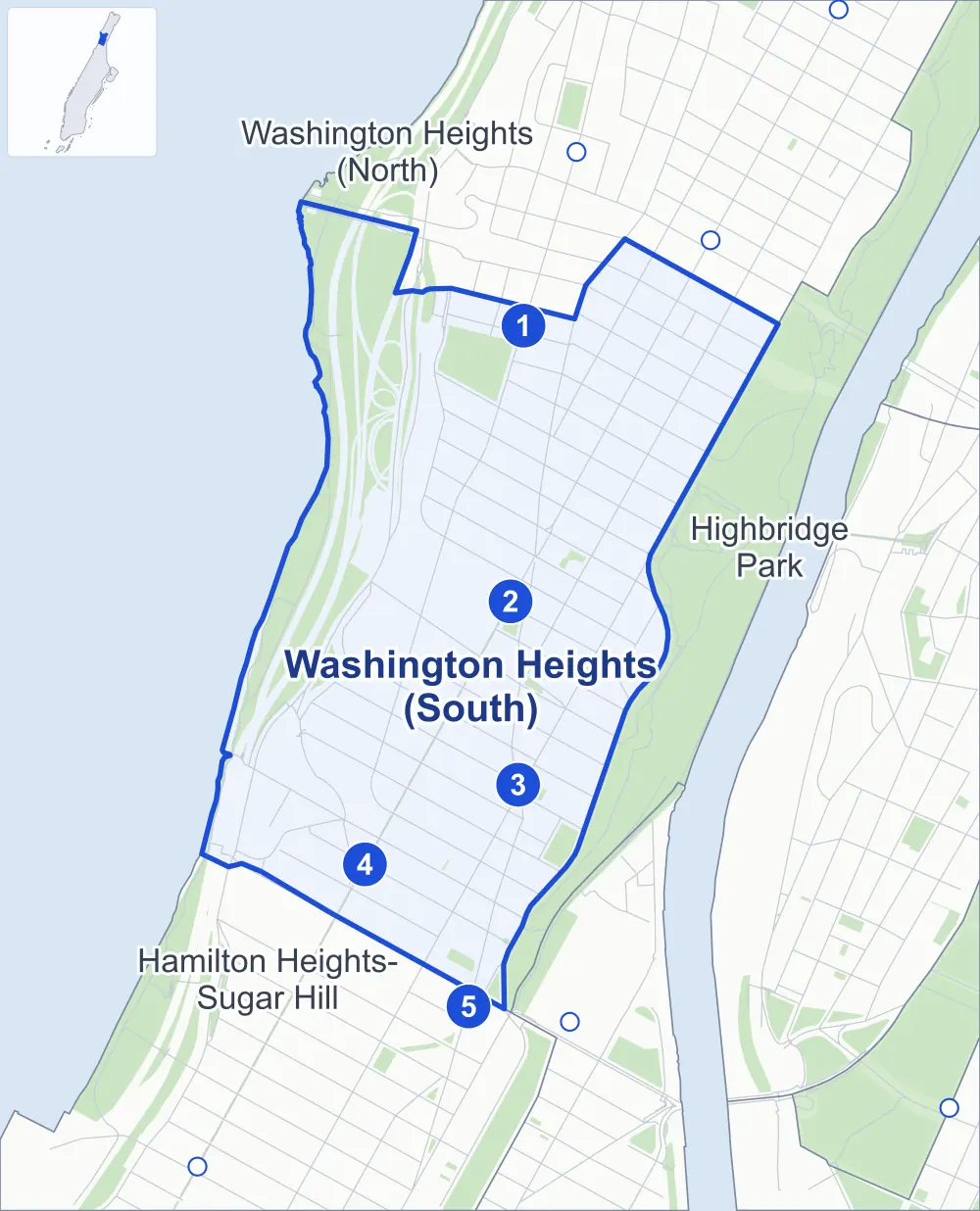
- Washington Heights (South)
- A neighboring area
- Park
- A station in the list
- Another station
Neighborhood areas and streets: NYC Department of City Planning. Parks: NYC Parks. Stations: MTA.
Neighboring areas
- Washington Heights (North) north
- Highbridge Park southeast
- Hamilton Heights-Sugar Hill south
Subway stations
- 175 St lines A accessible
- 168 St / 168 St-Washington Hts lines 1 A C
- 163 St-Amsterdam Av lines C
- 157 St lines 1
- 155 St lines C
Getting around
Five subway stations and buses on 16 routes stop in or at the edge of Washington Heights (South).
- 5 subway stations
- 1 of them listed by the MTA as fully accessible
- 16 local bus routes
Local bus routes
- Bx3
- Bx6
- Bx6-SBS
- Bx7
- Bx11
- Bx13
- Bx35
- Bx36
- M2
- M3
- M4
- M5
- M98
- M100
- M101
- T204
Safety record
Between 2021 and 2025, its corners averaged fewer police-reported crashes than the average Manhattan corner.
- 2,098 police-reported crashes at its corners
- 12.2 a corner, on average
- 13.4 the average Manhattan corner
- 15 corners with a clean record
Signal or safety changes on City record, at 69 of its corners
- Leading pedestrian intervals
- 47
- Accessible pedestrian signals
- 20
- Turn calming
- 11
- Barnes Dance all-way crossings
- 6
- Enhanced crossings
- 4
- Safety Improvement Projects
- 4
Camera tickets
In 2025 its corners had more school-zone speed camera tickets than red-light or bus-lane tickets.
- 0 red-light camera tickets
- 3,653 school-zone speed camera tickets at six corners
- 0 bus-lane camera tickets
- Most speed tickets
- Broadway & West 155th Street, 1,100
People and homes
The 2020 Census counted 72,037 residents in Washington Heights (South), about 96,000 per square mile.
- 28,457 homes, 2020 Census
- 565 homes added since April 2010, net, by City Planning's count
Half of its 996 residential lots hold buildings from 1910 or earlier, and 95% of them date from before 1940, by the City's tax lot records.
Parks and landmarks
- Parkland
- 64.1 acres of NYC Parks property
- The largest pieces
- Fort Washington Park (53.3 acres), J. Hood Wright Park (6.7 acres) and Roger Morris Park (1.6 acres)
- Designated landmarks
- The Fort Washington Presbyterian Church, 555 Edgecombe Avenue Apartments, the United Palace and the Fire Engine Company No. 84 and Hook & Ladder Company No. 34
- Historic districts
- Audubon Park, Audubon Terrace and Jumel Terrace, wholly or partly within Washington Heights (South)
Streets and trees
- Trees
- 4,030 in NYC Parks' records, most often thornless honeylocust, pin oak and London planetree
- Street with the most corners
- Amsterdam Avenue, with 27 of the area's 172
- Height above sea level
- From 10 feet at Henry Hudson Parkway & West 155th Street Pedestrian Underpass to 211 feet at Broadway & West 173rd Street
- Honorary street names
- 27 at its corners, enacted by local law
Schools and libraries
The City lists 20 schools and two libraries in Washington Heights (South).
- Public schools
- 15
- Charter and private schools
- 5
- Libraries
- Fort Washington Library and Washington Heights Library
Bike share and public art
By the station list of October 3, 2026, 21 bike-share stations stand in Washington Heights (South). The City's public art inventory lists three works in the area: Washington Heights-Inwood War Memorial (1922), 3000 A.D. Diffusion Piece (1974) and The Source (2015).
- 21 bike-share stations
- 3 works of public art
Public safety
How complaints are countedIn 2025 the NYPD recorded 875 major felonies at places in Washington Heights (South).
Recorded by the NYPD at places in Washington Heights (South)
- 869 major felonies in 2024
- 3,232 other felonies, misdemeanors and violations in 2025
In 2025, on the streets along the edge of Washington Heights (South), the NYPD recorded another 106 major felonies. Counting the streets along its edge, in 2025 the NYPD recorded 13.6 major felonies for every thousand residents the 2020 Census counted in Washington Heights (South).
- Police precincts
- 33rd (most of the area), 34th
From January to June 2026 the NYPD recorded 407 major felonies at places in Washington Heights (South), against 411 in the same months of 2025.
Sources: the NYPD's Complaint Data Historic, updated April 28, 2026, and Complaint Data Current (Year To Date), updated July 27, 2026, on NYC Open Data. Figures to June 30, 2026.
Street corners
- Amsterdam Avenue & Edgecombe Avenue
- Amsterdam Avenue & Harlem River Drive
- Amsterdam Avenue & St Nicholas Avenue
- Amsterdam Avenue & West 156th Street
- Amsterdam Avenue & West 157th Street
- Amsterdam Avenue & West 158th Street
- Amsterdam Avenue & West 159th Street
- Amsterdam Avenue & West 160th Street
- Amsterdam Avenue & West 161st Street
- Amsterdam Avenue & West 163rd Street
- Amsterdam Avenue & West 164th Street
- Amsterdam Avenue & West 165th Street
- Amsterdam Avenue & West 166th Street
- Amsterdam Avenue & West 167th Street
- Amsterdam Avenue & West 168th Street
- Amsterdam Avenue & West 169th Street
- Amsterdam Avenue & West 170th Street
- Amsterdam Avenue & West 172nd Street
- Amsterdam Avenue & West 173rd Street
- Amsterdam Avenue & West 174th Street
- Amsterdam Avenue & West 175th Street
- Amsterdam Avenue & West 176th Street
- Amsterdam Avenue & West 177th Street
- Amsterdam Avenue & West 178th Street
- Amsterdam Avenue & West 179th Street
- Audubon Avenue & West 165th Street
- Audubon Avenue & West 166th Street
- Audubon Avenue & West 167th Street
- Audubon Avenue & West 168th Street
- Audubon Avenue & West 169th Street
- Audubon Avenue & West 170th Street
- Audubon Avenue & West 171st Street
- Audubon Avenue & West 172nd Street
- Audubon Avenue & West 173rd Street
- Audubon Avenue & West 174th Street
- Audubon Avenue & West 175th Street
- Audubon Avenue & West 176th Street
- Audubon Avenue & West 177th Street
- Audubon Avenue & West 178th Street
- Audubon Avenue & West 179th Street
- Broadway & Fort Washington Avenue
- Broadway & St Nicholas Avenue
- Broadway & West 155th Street
- Broadway & West 156th Street
- Broadway & West 157th Street
- Broadway & West 158th Street
- Broadway & West 160th Street
- Broadway & West 161st Street
- Broadway & West 162nd Street
- Broadway & West 163rd Street
- Broadway & West 164th Street
- Broadway & West 165th Street
- Broadway & West 166th Street
- Broadway & West 168th Street
- Broadway & West 170th Street
- Broadway & West 171st Street
- Broadway & West 172nd Street
- Broadway & West 173rd Street
- Broadway & West 174th Street
- Broadway & West 175th Street
- Broadway & West 176th Street
- Broadway & West 178th Street
- Connector To Cross Bronx Expressway & Amsterdam Avenue
- Cross Bronx Expressway & Amsterdam Avenue
- Cross Bronx Expressway & Audubon Avenue
- Cross Bronx Expressway & Broadway
- Cross Bronx Expressway & Henry Hudson Parkway at West 176th Street Pedestrian Overpass
- Cross Bronx Expressway & St Nicholas Avenue
- Cross Bronx Expressway & Wadsworth Avenue
- Cross Bronx Expressway & West 178-179th Street Pedestrian Overpass
- Edgecombe Avenue & Jumel Place
- Edgecombe Avenue & West 157th Street
- Edgecombe Avenue & West 158th Street
- Edgecombe Avenue & West 159th Street
- Edgecombe Avenue & West 160th Street
- Edgecombe Avenue & West 162nd Street
- Edgecombe Avenue & West 163rd Street
- Edgecombe Avenue & West 164th Street
- Edgecombe Avenue & West 165th Street
- Edgecombe Avenue & West 166th Street
- Edgecombe Avenue & West 167th Street
- Edgecombe Avenue & West 170th Street
- Fort Washington Avenue & West 160th Street
- Fort Washington Avenue & West 161st Street
- Fort Washington Avenue & West 162nd Street
- Fort Washington Avenue & West 163rd Street
- Fort Washington Avenue & West 164th Street
- Fort Washington Avenue & West 165th Street
- Fort Washington Avenue & West 168th Street
- Fort Washington Avenue & West 169th Street
- Fort Washington Avenue & West 170th Street
- Fort Washington Avenue & West 171st Street
- Fort Washington Avenue & West 172nd Street
- Fort Washington Avenue & West 173rd Street
- Fort Washington Avenue & West 174th Street
- Fort Washington Avenue & West 175th Street
- Fort Washington Avenue & West 176th Street
- Haven Avenue & West 169th Street
- Haven Avenue & West 170th Street
- Haven Avenue & West 171st Street
- Haven Avenue & West 172nd Street
- Haven Avenue & West 176th Street Pedestrian Overpass (north)
- Haven Avenue & West 176th Street Pedestrian Overpass (south)
- Haven Avenue & West 177th Street
- Henry Hudson Parkway & Cross Bronx Expressway (north-east)
- Henry Hudson Parkway & Cross Bronx Expressway (south-west)
- Henry Hudson Parkway & West 155th Street Pedestrian Underpass
- Henry Hudson Parkway & West 155th Street Pedestrian Underpass (Exit 13)
- Henry Hudson Parkway & West 155th Street Pedestrian Underpass (West 158th Street)
- Henry Hudson Parkway & West 158th Street
- Henry Hudson Parkway & West 158th Street at West 158th Street Pedestrian Underpass
- Henry Hudson Parkway & West 158th Street Pedestrian Underpass
- Jumel Place & West 167th Street
- Jumel Terrace & Sylvan Terrace
- Pinehurst Avenue & West 177th Street
- Riverside Drive & Cross Bronx Expressway (north)
- Riverside Drive & Cross Bronx Expressway (south)
- Riverside Drive & Cross Bronx Expressway at Henry Hudson Parkway (north)
- Riverside Drive & Cross Bronx Expressway at Henry Hudson Parkway (south)
- Riverside Drive & George Washington Bridge Entrance Upper Level
- Riverside Drive & Henry Hudson Parkway (Exit 14N)
- Riverside Drive & Henry Hudson Parkway (north)
- Riverside Drive & Henry Hudson Parkway (south)
- Riverside Drive & West 157th Street
- Riverside Drive & West 158th Street
- Riverside Drive & West 160th Street
- Riverside Drive & West 161st Street
- Riverside Drive & West 162nd Street
- Riverside Drive & West 163rd Street
- Riverside Drive & West 165th Street
- St Nicholas Avenue & Sylvan Terrace
- St Nicholas Avenue & West 155th Street
- St Nicholas Avenue & West 157th Street
- St Nicholas Avenue & West 158th Street
- St Nicholas Avenue & West 159th Street
- St Nicholas Avenue & West 160th Street
- St Nicholas Avenue & West 161st Street
- St Nicholas Avenue & West 162nd Street
- St Nicholas Avenue & West 163rd Street
- St Nicholas Avenue & West 164th Street
- St Nicholas Avenue & West 165th Street
- St Nicholas Avenue & West 166th Street
- St Nicholas Avenue & West 167th Street
- St Nicholas Avenue & West 168th Street
- St Nicholas Avenue & West 170th Street
- St Nicholas Avenue & West 171st Street
- St Nicholas Avenue & West 172nd Street
- St Nicholas Avenue & West 173rd Street
- St Nicholas Avenue & West 174th Street
- St Nicholas Avenue & West 175th Street
- St Nicholas Avenue & West 176th Street
- St Nicholas Avenue & West 177th Street
- St Nicholas Avenue & West 178th Street
- St Nicholas Avenue & West 179th Street
- Wadsworth Avenue & West 173rd Street
- Wadsworth Avenue & West 174th Street
- Wadsworth Avenue & West 175th Street
- Wadsworth Avenue & West 176th Street
- Wadsworth Avenue & West 177th Street
- Wadsworth Avenue & West 178th Street
- Wadsworth Avenue & West 179th Street
- West 155th Street & West 155th Street Pedestrian Underpass
- West 157th Street & Edward M Morgan Place
- West 160th Street & Jumel Terrace
- West 162nd Street & Jumel Terrace
- West 168th Street & Haven Avenue
- West 168th Street & Jumel Place
- West 173rd Street & Haven Avenue
- West 176th Street & Haven Avenue
- West 176th Street & South Pinehurst Avenue
- West 178th Street & West 178-179th Street Pedestrian Overpass
- West 179th Street & West 178-179th Street Pedestrian Overpass
How the figures above are measured: Methodology.