Upper East Side-Carnegie Hill
Neighborhood · Manhattan
Upper East Side-Carnegie Hill runs east from Central Park and reaches north through Carnegie Hill to 96th Street.
- 0.72 square miles
- 62,410 residents, 2020 Census
- 175 street corners
- 6 subway stations
- 29 bus routes
Carnegie Hill is named for the mansion Andrew Carnegie built in the early 1900s at Fifth Avenue and 91st Street, now the Cooper Hewitt, Smithsonian Design Museum, and its historic district was designated in 1974. The neighborhood also holds the Jewish Museum and Frank Lloyd Wright's Guggenheim Museum, which opened on Fifth Avenue in 1959 and in 2019 joined a UNESCO World Heritage listing of eight of his buildings. Farther south on Fifth Avenue, the Frick Collection stands on the former site of the Lenox Library.
Sources: Carnegie Hill (Wikipedia); The 20th-Century Architecture of Frank Lloyd Wright (UNESCO World Heritage Centre); Lenox Hill, Manhattan (Wikipedia).
Upper East Side-Carnegie Hill borders six areas, and Madison Avenue holds more of its corners than any other street, 38 of 175.
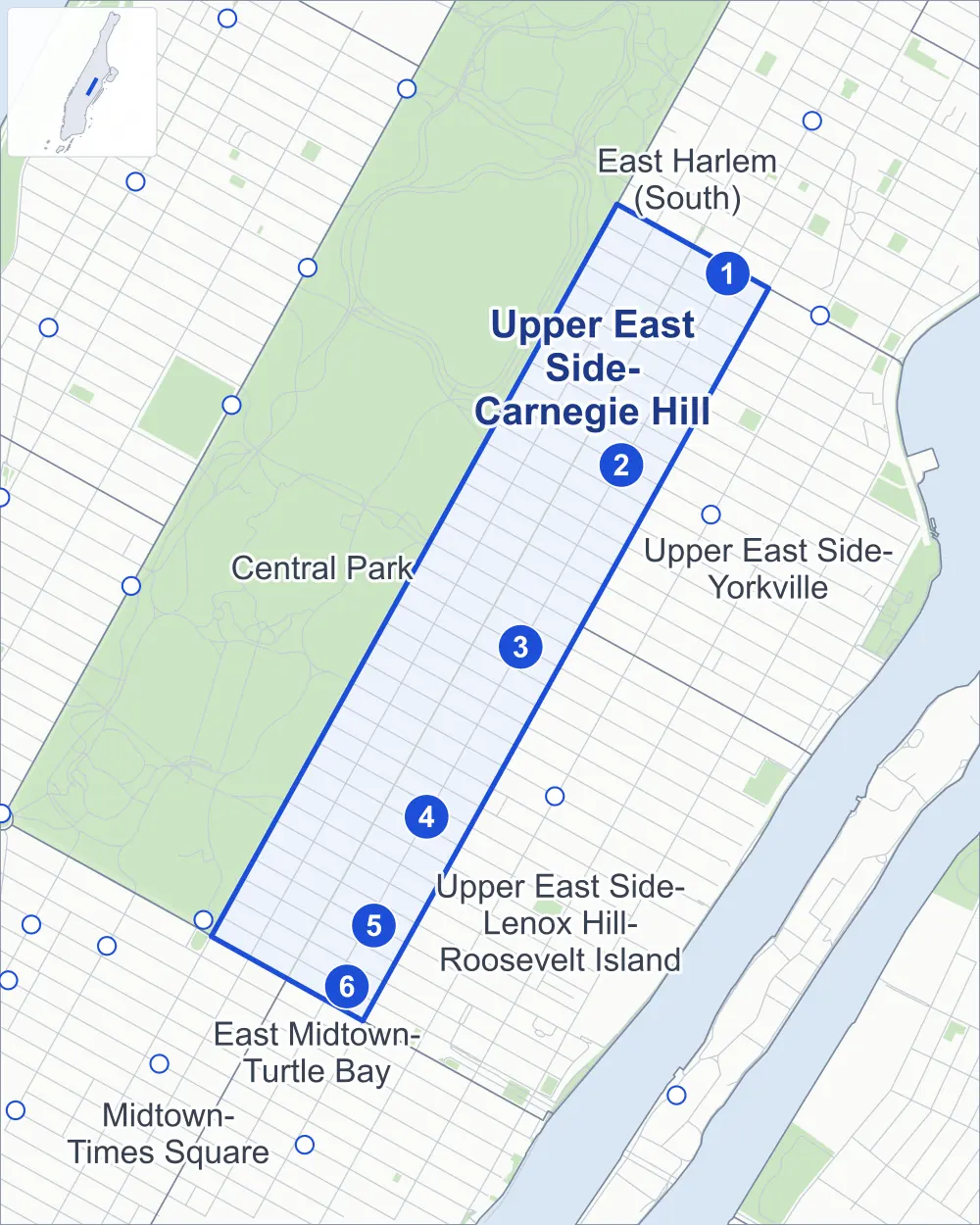
- Upper East Side-Carnegie Hill
- A neighboring area
- Park
- A station in the list
- Another station
Neighborhood areas and streets: NYC Department of City Planning. Parks: NYC Parks. Stations: MTA.
Neighboring areas
- Upper East Side-Yorkville northeast
- East Harlem (South) northeast
- Upper East Side-Lenox Hill-Roosevelt Island south
- East Midtown-Turtle Bay southwest
- Midtown-Times Square southwest
- Central Park northwest
Subway stations
- 96 St lines 6
- 86 St lines 4 5 6
- 77 St lines 6
- 68 St-Hunter College lines 6 accessible
- Lexington Av/63 St lines M Q accessible
- 59 St / Lexington Av/59 St lines 4 5 6 N R W
Getting around
Six subway stations and buses on 29 routes stop in or at the edge of Upper East Side-Carnegie Hill.
- 6 subway stations
- 2 of them listed by the MTA as fully accessible
- 15 local bus routes
- 14 express bus routes
Local bus routes
- M1
- M2
- M3
- M4
- M66
- M72
- M79-SBS
- M86-SBS
- M96
- M98
- M101
- M102
- M103
- M106
- Q32
Express bus routes
- BxM1
- BxM2
- BxM3
- BxM4
- BxM6
- BxM7
- BxM8
- BxM9
- BxM10
- BxM11
- QM2
- QM20
- SIM23
- SIM24
Safety record
Between 2021 and 2025, its corners averaged fewer police-reported crashes than the average Manhattan corner.
- 1,932 police-reported crashes at its corners
- 11.0 a corner, on average
- 13.4 the average Manhattan corner
Signal or safety changes on City record, at 172 of its corners
- Leading pedestrian intervals
- 155
- Accessible pedestrian signals
- 52
- Turn calming
- 20
- Barnes Dance all-way crossings
- 13
- Safety Improvement Projects
- 4
Camera tickets
In 2025 its corners had more school-zone speed camera tickets than bus-lane or red-light tickets.
- 981 red-light camera tickets at one corner
- 15,531 school-zone speed camera tickets at 12 corners
- 9,592 bus-lane camera tickets at five corners
- Most red-light tickets
- Madison Avenue & East 96th Street, 981
- Most speed tickets
- Park Avenue & East 68th Street, 4,344
- Most bus-lane tickets
- Lexington Avenue & East 75th Street, 3,610
People and homes
The 2020 Census counted 62,410 residents in Upper East Side-Carnegie Hill, about 86,700 per square mile.
- 37,551 homes, 2020 Census
Half of its 2,249 residential lots hold buildings from 1905 or earlier, and 90% of them date from before 1940, by the City's tax lot records.
Parks and landmarks
- Parkland
- 0.8 acre of Samuel Seabury Playground, as NYC Parks maps it within Upper East Side-Carnegie Hill
- Designated landmarks
- The Regis High School, the George Rives Residence, the Squadron "A" Armory and the Clarence Dillion House, among others
- Historic districts
- Expanded Carnegie Hill, Hardenbergh/Rhinelander, Metropolitan Museum, Park Avenue and Upper East Side, wholly or partly within Upper East Side-Carnegie Hill
Streets and trees
- Trees
- 4,112 in NYC Parks' records, most often thornless honeylocust, maidenhair tree and Callery pear
- Street with the most corners
- Madison Avenue, with 38 of the area's 175
- Height above sea level
- From 43 feet at 3rd Avenue & East 96th Street to 117 feet at Park Avenue & East 93rd Street
- Honorary street names
- 5 at its corners, enacted by local law
Schools and libraries
The City lists 33 schools and one library in Upper East Side-Carnegie Hill.
- Public schools
- 4
- Charter and private schools
- 29
- Library
- 96th Street Library
Bike share and public art
By the station list of October 3, 2026, 17 bike-share stations stand in Upper East Side-Carnegie Hill. The City's public art inventory lists one work in the area: Night Presence IV (1973).
- 17 bike-share stations
- 1 work of public art
Public safety
How complaints are countedIn 2025 the NYPD recorded 704 major felonies at places in Upper East Side-Carnegie Hill.
Recorded by the NYPD at places in Upper East Side-Carnegie Hill
- 796 major felonies in 2024 92 fewer in 2025
- 1,437 other felonies, misdemeanors and violations in 2025
In 2025, on the streets along the edge of Upper East Side-Carnegie Hill, the NYPD recorded another 424 major felonies. Counting the streets along its edge, in 2025 the NYPD recorded 18.1 major felonies for every thousand residents the 2020 Census counted in Upper East Side-Carnegie Hill.
- Police precinct
- 19th
From January to June 2026 the NYPD recorded 289 major felonies at places in Upper East Side-Carnegie Hill, against 381 in the same months of 2025.
Sources: the NYPD's Complaint Data Historic, updated April 28, 2026, and Complaint Data Current (Year To Date), updated July 27, 2026, on NYC Open Data. Figures to June 30, 2026.
Street corners
- 3rd Avenue & East 60th Street
- 3rd Avenue & East 61st Street
- 3rd Avenue & East 64th Street
- 3rd Avenue & East 66th Street
- 3rd Avenue & East 68th Street
- 3rd Avenue & East 69th Street
- 3rd Avenue & East 71st Street
- 3rd Avenue & East 72nd Street
- 3rd Avenue & East 73rd Street
- 3rd Avenue & East 74th Street
- 3rd Avenue & East 77th Street
- 3rd Avenue & East 78th Street
- 3rd Avenue & East 79th Street
- 3rd Avenue & East 80th Street
- 3rd Avenue & East 83rd Street
- 3rd Avenue & East 84th Street
- 3rd Avenue & East 85th Street
- 3rd Avenue & East 86th Street
- 3rd Avenue & East 87th Street
- 3rd Avenue & East 89th Street
- 3rd Avenue & East 90th Street
- 3rd Avenue & East 91st Street
- 3rd Avenue & East 93rd Street
- 3rd Avenue & East 94th Street
- 3rd Avenue & East 95th Street
- 3rd Avenue & East 96th Street
- 5th Avenue & 65th Street Transverse at East 65th Street
- 5th Avenue & 65th Street Transverse at East 66th Street
- 5th Avenue & 79th Street Transverse
- 5th Avenue & East 60th Street
- 5th Avenue & East 61st Street
- 5th Avenue & East 62nd Street
- 5th Avenue & East 63rd Street
- 5th Avenue & East 64th Street
- 5th Avenue & East 67th Street
- 5th Avenue & East 68th Street
- 5th Avenue & East 69th Street
- 5th Avenue & East 70th Street
- 5th Avenue & East 71st Street
- 5th Avenue & East 72nd Street
- 5th Avenue & East 73rd Street
- 5th Avenue & East 74th Street
- 5th Avenue & East 75th Street
- 5th Avenue & East 76th Street
- 5th Avenue & East 77th Street
- 5th Avenue & East 78th Street
- 5th Avenue & East 80th Street
- 5th Avenue & East 81st Street
- 5th Avenue & East 82nd Street
- 5th Avenue & East 83rd Street
- 5th Avenue & East 84th Street
- 5th Avenue & East 85th Street
- 5th Avenue & East 86th Street
- 5th Avenue & East 87th Street
- 5th Avenue & East 88th Street
- 5th Avenue & East 89th Street
- 5th Avenue & East 90th Street
- 5th Avenue & East 91st Street
- 5th Avenue & East 92nd Street
- 5th Avenue & East 93rd Street
- 5th Avenue & East 94th Street
- 5th Avenue & East 95th Street
- 5th Avenue & East 96th Street
- Lexington Avenue & East 59th Street
- Lexington Avenue & East 60th Street
- Lexington Avenue & East 61st Street
- Lexington Avenue & East 62nd Street
- Lexington Avenue & East 63rd Street
- Lexington Avenue & East 64th Street
- Lexington Avenue & East 65th Street
- Lexington Avenue & East 66th Street
- Lexington Avenue & East 67th Street
- Lexington Avenue & East 68th Street
- Lexington Avenue & East 69th Street
- Lexington Avenue & East 70th Street
- Lexington Avenue & East 71st Street
- Lexington Avenue & East 72nd Street
- Lexington Avenue & East 73rd Street
- Lexington Avenue & East 74th Street
- Lexington Avenue & East 75th Street
- Lexington Avenue & East 76th Street
- Lexington Avenue & East 77th Street
- Lexington Avenue & East 78th Street
- Lexington Avenue & East 79th Street
- Lexington Avenue & East 80th Street
- Lexington Avenue & East 81st Street
- Lexington Avenue & East 82nd Street
- Lexington Avenue & East 83rd Street
- Lexington Avenue & East 84th Street
- Lexington Avenue & East 85th Street
- Lexington Avenue & East 86th Street
- Lexington Avenue & East 87th Street
- Lexington Avenue & East 88th Street
- Lexington Avenue & East 89th Street
- Lexington Avenue & East 90th Street
- Lexington Avenue & East 91st Street
- Lexington Avenue & East 92nd Street
- Lexington Avenue & East 93rd Street
- Lexington Avenue & East 94th Street
- Lexington Avenue & East 95th Street
- Madison Avenue & East 59th Street
- Madison Avenue & East 60th Street
- Madison Avenue & East 61st Street
- Madison Avenue & East 62nd Street
- Madison Avenue & East 63rd Street
- Madison Avenue & East 64th Street
- Madison Avenue & East 65th Street
- Madison Avenue & East 66th Street
- Madison Avenue & East 67th Street
- Madison Avenue & East 68th Street
- Madison Avenue & East 69th Street
- Madison Avenue & East 70th Street
- Madison Avenue & East 71st Street
- Madison Avenue & East 72nd Street
- Madison Avenue & East 73rd Street
- Madison Avenue & East 74th Street
- Madison Avenue & East 75th Street
- Madison Avenue & East 76th Street
- Madison Avenue & East 77th Street
- Madison Avenue & East 78th Street
- Madison Avenue & East 79th Street
- Madison Avenue & East 80th Street
- Madison Avenue & East 81st Street
- Madison Avenue & East 82nd Street
- Madison Avenue & East 83rd Street
- Madison Avenue & East 84th Street
- Madison Avenue & East 85th Street
- Madison Avenue & East 86th Street
- Madison Avenue & East 87th Street
- Madison Avenue & East 88th Street
- Madison Avenue & East 89th Street
- Madison Avenue & East 90th Street
- Madison Avenue & East 91st Street
- Madison Avenue & East 92nd Street
- Madison Avenue & East 93rd Street
- Madison Avenue & East 94th Street
- Madison Avenue & East 95th Street
- Madison Avenue & East 96th Street
- Park Avenue & East 60th Street
- Park Avenue & East 61st Street
- Park Avenue & East 62nd Street
- Park Avenue & East 63rd Street
- Park Avenue & East 64th Street
- Park Avenue & East 65th Street
- Park Avenue & East 66th Street
- Park Avenue & East 67th Street
- Park Avenue & East 68th Street
- Park Avenue & East 69th Street
- Park Avenue & East 70th Street
- Park Avenue & East 71st Street
- Park Avenue & East 72nd Street
- Park Avenue & East 73rd Street
- Park Avenue & East 74th Street
- Park Avenue & East 75th Street
- Park Avenue & East 76th Street
- Park Avenue & East 77th Street
- Park Avenue & East 78th Street
- Park Avenue & East 79th Street
- Park Avenue & East 80th Street
- Park Avenue & East 81st Street
- Park Avenue & East 82nd Street
- Park Avenue & East 83rd Street
- Park Avenue & East 84th Street
- Park Avenue & East 85th Street
- Park Avenue & East 86th Street
- Park Avenue & East 87th Street
- Park Avenue & East 88th Street
- Park Avenue & East 89th Street
- Park Avenue & East 90th Street
- Park Avenue & East 91st Street
- Park Avenue & East 92nd Street
- Park Avenue & East 93rd Street
- Park Avenue & East 94th Street
- Park Avenue & East 95th Street
- Park Avenue & East 96th Street
How the figures above are measured: Methodology.